In our last episode we were at Black Rock (it should be Black Rock Point, or something, but isn't) checking out Lone Mountain and the Boss Mine. Before leaving, I managed—with my handy-dandy, relatively new Nikon DSLR with 18-300 mm zoom—to get this shot of the far-away Crescent Dunes solar thermal power plant, which reportedly went online in February.
 |
| The power tower and mirrors of Crescent Dune in front of the San Antonio Mountains. Part of the defunct Hall moly mine can be seen on the far left. The tower is about 18.5 miles distant in this photo. |
As we drifted south from Tonopah, side roads tried to distract us from our goal of reaching Beatty that night. So much to see! So many possibilities! We resisted being drawn astray (resistance is sometimes but not always futile), but upon spotting the first batch of Joshua trees just north of Goldfied, we gave in and pulled over to take a look.
It turns out that we pulled over only to take photos of a tree I had photographed in 2010 and posted about here.
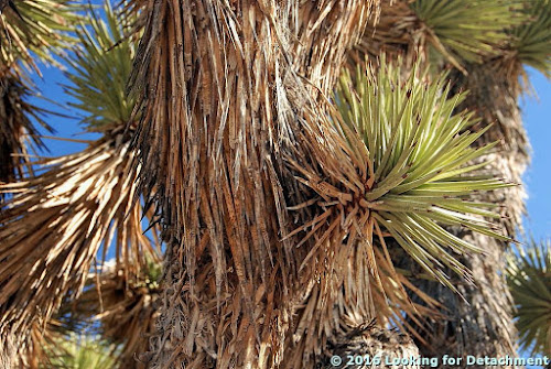
Several views of my favorite Joshua tree:
 |
| Relatively close view of the large-ish Joshua tree we stopped for. |
 |
| A closer view. |
 |
| Unbranched yucca with Lone Mountain on the horizon. |
 |
| A closer view of the leaves of the non-branched tree. |
 |
| The entirety of the Joshua tree from the first two photos. Lone Mountain is on the left (NW); the hill going into Tonopah is over there on the right (N). |
There was a weak to moderate desert pavement across the area, and we hunted around for ventifacts. Not sure if these two rocks qualify, but they do show typical varnish:
 |
| The varnished rocks are probably probably volcanic. |
 |
| More Joshua trees against the backdrop of the volcanic mesas to the west. |
 |
| Stonewall Mountain is partly in and partly outside Nellis, so it's possible I'll get up to the west side someday, to look at those brightly colored volcanic rocks. |
 |
| Sunlit alluvial fan rills, shadows on the colorful mountains, and Joshua trees. |
Related Posts (in order of posting):
Death Valley, "Super" Blooms, Turtlebacks, and Detachments
Death Valley Trip, Part 2: More of the Badwater Turtleback Fault
Death Valley Trip, Part 3: Northward, and over Daylight Pass
Death Valley Trip, Getting There: Wave Clouds beyond the Sierra
Death Valley Trip, Getting There: A Hike to Pleistocene Shorelines
Death Valley Trip, Getting There: Walker Lake, Road Stories, A Bit about Copper, and Some Folds near Luning
Death Valley Trip, Getting There: A Jeep Trail, Folds and Cartoons of Folds, Even More Folds, and Boundary Peak
Death Valley Trip, Getting There: Highway 95, Redlich, Columbus Salt Marsh, and Another View of Boundary Peak
Death Valley Trip, Getting There: Coaldale, Black Rock, Lone Mountain, and the Boss Mine

No comments:
Post a Comment