
Okay, so
yesterday's post was really a lead in and good excuse to get to one of exploration's finest perquisites, that of being able to wander around old mining districts and check out everything left behind by previous operations, sometimes going back to the late 1800's.
The miscellaneous piles of junk and still-standing or semi-standing parts of mills and old buildings that I found at the mouth of Ophir Canyon is supposedly part of the old Warfield-Ophir group of claims (any current claims may have different names by now), according to Kleinhampl and Ziony, 1984. The area was worked for tungsten (and molybdenum?) in the past, with the most recent mining efforts possibly being from
the mid-1970's, but reports and locations are unclear.
The main part of the Ophir or Twin River silver-tungsten-gold mining district, at the old townsite of
Ophir, AKA Toiyabe City, is farther up the canyon and is also well worth visiting.
 This appears to be a
 fly wheel flat pulley, possibly from a crusher. If anyone can identify this equipment more completely, please let me know. I just like the shapes and colors, and didn't spend a lot of time - this time - looking for manufacturers' names and dates.
 Yellow-painted meal framework and grating, with pipes and wires.
 And old dump truck or haul truck, filled with rock. Is it scheelite ore?
 A nicely colorful metal roof on an otherwise falling down shack. Photos of this cabin from about 2002, when it was still standing, along with photos of the entire equipment setup, can be seen here, near the bottom of their webpage.
 Falling down cabin, with the metal roof being much sturdier than the rest of the building. A low part of the Toquima Range can be seen in the background: Moore's Creek to Dry Canyon to Road Canyon (or Charnock Pass) - a scenic, volcanic-rock ridden way into Monitor Valley.
 Here's a view of the northern and central Northumberland caldera, which erupted the Northumberland Tuff about 32 million years ago. Also seen in the view is the area in which I stayed out all night once, just south (right) of Wildcat Peak, the pointed peak on the horizon, and the tuff of Hoodoo Canyon, a bit to the north (left) of that peak.
 Another view of the central part of the Northumberland caldera, through more metal frameworks.
 I've retreated now to my parking area, near the creek seen in yesterday's post, giving yet another view of the central and northern part of the Northumberland caldera, across the vast expanse of Big Smoky Valley.
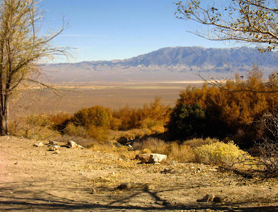 And here, on a ledge where possibly some old buildings once stood, one can see across the valley to the southeast, getting a good view of Mt. Jefferson, which at 11,941 feet is essentially the third highest mountain in Nevada. Mt. Jefferson consists primarily of a huge pile of Tertiary volcanic rocks, mostly moderately to strongly welded ash-flow tuffs, including the tuff of Mt. Jefferson, which erupted from Mt. Jefferson caldera about 26.7 million years ago. Much more detail about the calderas in and around Mt. Jefferson is discussed here.
Mt. Jefferson is a great place to hike up, if you can stand the elevations, and even if you can't. The top, which is not accessible by vehicles, is almost surreal somehow - or maybe I was oxygen starved. It's mostly flat, with little hills of tuff. The Alta Toquima archaeological site sits up there at about 11,000 feet, above tree line.
 Driving away from Ophir Canyon, I had a great view of the Round Mountain gold mine to the southwest. Round Mountain has been in operation since
 the early 1980's 1977.
References:
Kleinhample and Ziony, 1984, Mineral resources of northern Nye County, Nevada, NBMG Bulletin 99B.
McKee, E.H., 1974, Northumberland caldera and Northumberland tuff, in Guidebook to the geology of four Tertiary volcanic centers in central Nevada: Nevada Bureau of Mines and Geology
Report 19, p. 35-41.
Thomas, D.H., 1982. The 1981 Alta Toquima Village Project: a preliminary report. Desert Res. Inst. Soc. Sci. Cent. Tech. Rep. 27.


