Showing posts with label rant. Show all posts

Tuesday, February 7, 2017

From the Road: Talus Stripes and Shorelines along the Truckee River

Talus, shorelines, and fall colors.
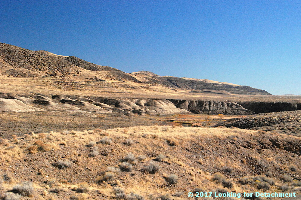
It was a late fall day, and I stopped along Route 447 to see if I could get close to some of the brilliantly colored trees along the Truckee River a few miles north of Wadsworth. I didn't end up finding a good spot for pics of fall colors—other than maybe this one taken down near the Numana Hatchery—but I did find lots of wonderful talus stripes and some Lake Lahontan shorelines.

At two stops a little farther to the north, at and near the junction of 447 with Chicken Road and at the Historic Marker 448 pullout, I grabbed a hodgepodge of photos.
Looking SSE from the historic marker pullout.
These two photos look south-southeastward along the Truckee River toward distant Fernley. A good portion of the river in this area runs parallel or sub-parallel to Walker Lane strike-slip faults. Wadsworth Amphitheater, which shows up in the Google Earth images we'll see in a minute, is not visible from any of our photo sites; it's an amphitheater-shaped topographic feature cut into Lake Lahontan sediments right along the east bank of the Truckee, beyond the dark basaltic hills on the right side of these two photos (east side of the Truckee).
I love the lone Cottonwood in this photo.
I went ahead and drew a few lines on Google Earth, then I rotated the resulting images to two different orientations so we could see a little more of the terrain. Be sure to check the north arrow in the upper right! The linears I drew are parallel or sub-parallel to the trend of the Walker Lane. You might be able to pick out a few more in the images (or go to Google Earth and looking around a bit).

The Walker Lane—on Google Earth (G.E.)and on other aerial representations such as air photos—shows up best at very small scales; that is, if we zoom way out and observe the area from way above, we can see the trend of the Walker Lane better than if we zoom way in, like we've done here. Nevertheless, individual strike-slip faults have been identified throughout the Walker Lane, and a few of these occur right in this area.
The A is centered on Wadsworth Amphitheater. The purple camera icon shows the location of the first photo.
The next G.E. image zooms in to the area we can see in the photos. I've got all three photo locations turned on, the A for Wadsworth Amphitheater, and my drawn-in linears. These linears aren't necessarily faults, although I'm pretty sure the one on the far left is. Unfortunately, because I currently have a very lousy internet setup (thanks Frontier!), I can't load very many research web pages. Google works well—and Blogger is a Google product—so I can blog even with 25 to 100% packet loss (it's 50% this very moment). And because Google Earth is a Google product, it's working for me also! (But I can't routinely access my non-Google email.)

Back to the faults and linears. I do know from personal experience that Walker Lane structures pass through the Lake Lahontan sediments in the area where the Truckee is running in a particularly linear fashion. I know this from some work I did a long time ago with J.O. Davis, who was studying Lake Lahontan and using tephra beds to date various aspects of the stratigraphy. The two linears or faults in the lower right of the image cross through the area where I've seen older Lake Lahontan sediments faulted and highly contorted by the major structures that pass through the area. I can't say that my particular linears are right on the major structures, and I can see other possible lineaments.

UPDATE 3Feb2017: I now have good internet back, and I've been able to compare my "map" to a geologic map of the area (Bell, Garside, and House, 2005). My linear passing through the hatchery location (below) is spot on for their most prominent fault, which was mapped as a dominantly extensional fault.
A zoomed in G.E. view of the area.
Not sure why, but I prefer to spell amphitheater with an "re" at the end: amphitheatre. I also have a hard time sticking the first "h" into the word!

I sure wish Frontier was a better internet service provider! (I never had this kind of semi-routine trouble with AT&T in eastern and northern Nevada; their every-day speeds were faster, and service was (generally) provided more quickly.

Back to the photos! 😊
Horizontal Lahontan shorelines and vertical basaltic talus stripes.
Some of the same talus stripes in Google Earth.
This photo shows a juxtaposition of talus stripes, faint shorelines, and layered Lahontan sediments.
On this trip, I focused mostly on trying to get good photos of the talus, because that's really what caught my eye. I later noticed that a few shots showed the Lake Lahontan sediments fairly well.
White, gray, greenish gray, and pinkish layers of the Eetza Alloformation.
While driving through the area, I'd been assuming that the prominently exposed white units were part of the Sehoo Alloformation. I was wrong! The Sehoo is barely identifiable in this zoomed in photo, and it's the older Eetza that is most conspicuous. In fact, the Sehoo here is mapped as gravelly beach deposits, so it mostly comprises the dark gray or brownish gray layered deposits above the whitish units.

Note: I usually use "formation" when talking about the subdivisions within the Lake Lahontan section, but "alloformation" is technically correct. In explanation, Bell et al (2005) say this, "Lake Lahontan and related subaerial deposits were considered lithostratigraphic units in the early studies of Morrison and were designated as formations. With the revision of the North American Stratigraphic Code in 1983, new allostratigraphic and pedostratigraphic unit definitions were added which allowed the definition of time-transgressive, lithology-independent rock units and soils."
Qsm = middle member of the Sehoo Alloformation; Qe = Eetza Alloformation.
After taking all these photos, it was time to move on, so I looked to the north, in the direction I'd be heading.
What I saw was more talus, more shorelines, and more Lahontan sediments. (And some fall colors.)
Selected Reference:
Bell, J.W., Garside, L.J., and House, P.K., 2005, Geologic map of the Wadsworth Quadrangle, Washoe County, Nevada: Nevada Bur Mines and Geology Map 153.

Thursday, March 31, 2011

New Blog Viewing Formats

Blogger (i.e. Google) has created some new ways of viewing Blogger blogs, this first one being the Mosaic view of LFD, which shows posts roughly in time order from left to right, and then down the page apparently forever or as long as your browser can stand adding pictures and information. If you put your cursor over one of the blocks, like I've done over the Where it All Began II block, that enlarges; clicking takes you to a white-background version of the post. This is the Flipcard view: moving your cursor around will cause the smaller postblocks to flip (see fourth block from the left, top row); clicking gets you to a similar white-background version of the chosen post. These first two viewing options are the best, IMO. The Snapshot view isn't too bad: it shows all the pictures I've uploaded to the blog, but doesn't show posts without photos. Not so good, or best for true photo blogs, although it appears to make copying photos a little too easy, and my copyright statement isn't shown anywhere in any of these new views. Nor can my own personal blog sidebar be reached via any of these views. The Timeslide view isn't too bad, but is a little confusing as to actual timeline, presenting more of a general timeline. Some of the views, including Flipcard, Snapshot, and Timeline, move sideways to show you the white-background view of my blog. I find the sideways motion annoying and potentially migraine triggering. This Sidebar view is nearly useless in my opinion. Stick to my artistically formatted blog instead of this. It is, however, fairly fast in showing a blog post, which comes up just to the right of the post list.

These views can [no longer] be reached by adding "/view" without the quotes to the end of my blog URL. [Though you can try views on other Blogger blogs that haven't turned the option off like I just did.] You won't be able to reach them in IE unless you switch to Windows 7 and download IE 9. I didn't find them at all viable in Firefox, mostly way too slow. They are designed — surprise! — to work in Chrome: designed by Google to work in Google's browser. [And as noted by Chris Rowan in the comments, they work in Safari.]

For now [no longer - see update info below], these new views will be available here at LFD. I can turn off the new views in my formatting settings, but haven't decided whether or not to do that. I might like to choose one or two or three views to be available, but as of now, it's all or none. I think the views are interesting, but they take away from my own personal formatting and make everything look a little like a Picasa photo album (surprise, again). Only the first one, Mosaic, looks at all artistic to me.

/semi-rant

UPDATE 1April2011: These views are now turned off and are no longer available. I can't pick and choose, it's all or nothing, so therefore nada.

Wednesday, October 13, 2010

A Million Things and DonorsChoose

There is a lot going on around the geoblogosphere (and more than that) and it has been harder for me to post during this most recent round of 10 hour days than I remember it being back when I started blogging. Maybe my posts were much simpler then, just a photo or two, some update about the weather, a link or two, and move on.
First, before I get distracted, let me point you to what I think is one of the most important things going on this week and into next month: Anne Jefferson and Chris Rowan of Highly Allochthonous are sponsoring their annual Earth Science DonorsChoose Challenge, which brings earth science tools, projects, and supplies to students and classrooms in need of your support. Go to their giving page, where you will find several projects worth funding, as well as links to other Earth Science giving pages including one by Maitri of Maitri's VatulBlog. As a bonus, HP is matching the first $50,000 raised during the Science Bloggers for the Schools challenge, this week through November 9th. So, get to it!

Also, it's National Fossil Day, and Anne has a great post up about the John Day Fossil Beds National Monument in Oregon, which I visited very briefly this summer, and reported on equally as briefly. :)

Back to my rant: I get home after 10 hours at work, sometime between 5:10 and 5:30, and I've been doing that now for almost an entire month. After getting home, I might read a little online, have dinner, then maybe I'll have time to watch a Stargate Universe episode with MOH if he's not working nights. Then, after dinner, maybe I'll hang out online just a little more via mobile after getting ready for bed, or maybe I'll read. (Currently I'm reading - very slowly I might add - Roads: Driving America's Great Highways by Larry McMurtry).

In the morning, my alarm goes off at 4:30, I snooze it until as late as 5:00, make coffee, have coffee while reading blogs and news until maybe 6:00, at which time if I'm actually editing an already written post I might push it until 6:10 or so, then I get ready very quickly so I can be out the door at 6:40.

I think about blogging, not constantly, but often. I think about my many blog ideas, am in the midst of a few things already started, have Wedges to think about, and other stories in progress from earlier this year or last - and I bog down, or give up, or something - because the truth is, it just doesn't seem like there is that much time in the day.

I have access to a computer at work (not my computer, which would be much, much faster), but have not felt at all comfortable writing anything, even during coffee breaks or lunch. Instead, a couple-three of us get together and yak about things: work things, geological things, world of finance things, other things. One thing different than a couple years ago: I share a large room (a coreshed) with one or two other geo-types and don't have an office space to myself.

Then, on breaks between work periods, at least during these last 30 days, I've had a drive-to-meeting and drive-back-from-meeting break (two days); one whole day off, half of which was spent doing laundry; and a field-trip break (three days, all on the road). What I mean is, on breaks, I tend to be going somewhere, maybe because I'm not really traveling for work at the moment. During these various trips, I sometimes end up in a place without a good or easy-to-use internet connection, at least for a short time, or - as during the breaks over this last month - I end up in places where socializing and hanging out with other geos talking about old times, geology, the mining business, good stories, and other things takes precedence over all but the most cursory checking of things online via mobile in the late evening.

So, what this all boils down to, is that you - all my readers - are not getting many posts from me. And I don't see much to do about that right now!

Thursday, July 29, 2010

Whence the GeoBlogosphere

David Bressan and Michael Welland are co-hosting this month's Accretionary Wedge, which goes meta and asks questions about the Geoblogosphere and geoblogging. Where is the geoblogosphere going? Can geoblogging impact society? What is the purpose of geoblogging? Without going into a long rant about why I blog, which I've probably never done but which has been included in more than one blog and geoblog survey, I'll ramble into a few possibly related topics.

First off, when I speak of the Geoblogosphere, I include geologists, geophysicists, and other geoscientists who are blogging. Some of the bloggers in this larger Geoblogospheric group don't always blog about geology or geosciences, some do all or most of the time, some do occasionally to even rarely. This wide range of types of blogging — informal, formal, science-related, more personal — is really one of the things I like and enjoy about the Geoblogosphere as it is today and as it has been over the past couple-few years that I've been reading and blogging. I personally derive value from reading from a wide range of topics, and also in knowing — and sometimes even meeting — bloggers from many backgrounds, regions, and countries. For good summaries of geoblogging and the geoblogosphere see Active Margin, Clastic Detritus and Research at a Snail's Pace. I would also like to point out that Kim Hannula, Anne Jefferson, Suzanne Franks, and Pat Campbell studied women-in-science blogs (this blog is part of the Geoblogosphere and is also one of the many women-in-science blogs), and found that a diversity of blog types and topics is valuable to women. Their results were presented as a paper at the 2009 GSA Annual Meeting in Portland, Oregon, and are reported online here.

The Geoblogosphere as I know it consists of a broader range of geoscientists than the smaller, more restricted group I meet and know through professional and alumni associations.

The number of geobloggers seems to have increased greatly in the last year or so, at least judging by the number of feeds at AllGeo — and at Geoblogosphere News, which I don't follow as closely, but which aggregates a wide range of geoblogs. My sidebar GeoBlogosphere links also reflect this increase, though I list inactive to relatively inactive geoblogs, and have kept links to original blogs when a geoblogger has moved to a new site. What is inactive? Well, that's a matter of perception, and I've considered putting inactive geoblog links into another category, but haven't done that yet. Having them all there in my sidebar, listed alphabetically, is pleasing to me. I certainly don't have them all, especially on the palaeontology side of things — there are a huge number of palaeo blogs.

What does the Geoblogosphere do? We generally have strong to loose overlapping and intermingling groups of blog writers, who comment on each other's blogs, who sometimes meet here and there, who send each other information, who support each other in sometimes tangible and often intangible ways. Some geobloggers write about their research and the research of others. Some write about geology in a way that can interest both geologists and non-geologists. Some write more personal items and things not completely related to geoscience or work in the geosciences. Some are now writing articles for geo-magazines, or have written one or two magazine articles — which came about at least in part from our exposure at the 2009 GSA Annual Meeting in Portland.

Should the Geoblogosphere join together in a joint project of some kind? I'm not really sure what sort of thing that might be or who would coordinate it. I do know that several geobloggers have recently been involved in protesting the proposed removal of serpentinite as a state rock in California (see an incomplete list here). This geoblogging-tweeting-mediacontacting-letterwriting protest has been a way to (hopefully) increase people's understand about some geologic issues and terminology, and it arose naturally, without plan.

Possibly we in the Geoblogosphere are more civil than some bloggers in other parts of the science blogosphere. Possibly we used this general civility to our advantage with the above-mentioned serpentinite issue, an issue which was brought to our attention initially by Andrew Alden and Garry Hayes, and which was then carried on by many bloggers, including some outside our usual circle of geoblogs, many geotweeters and others on Twitter, and which was finally taken up by the MSM, who were contacted by @geotripper (Garry Hayes) and @westcenter (Jon Christensen). Would we garner more attention for this issue by loud shouting? Who knows? The activism aspect of geoblogging is described in more detail by Jim Repka.

Should the Geoblogosphere do more things like this? I don't know. I really hate the word "should."

Should we as a group promote ourselves somehow? I'm not really sure, other than the ways in which we promote currently, which is individually and also collectively as a group with a presence both in the blogosphere and on twitter.

Are blogs private business or public affairs? In musing on this question, I have to lean toward the idea that any given blog is what the blogger (author) wants and deems it to be, that there isn't and shouldn't be any one model of blogging or of geoblogging. Within this general topic, I have to say that I don't really like the idea of prior restraint (of topics or of blogging in general) by employers, but realize that many of the non-academic bloggers like myself have some kinds of blogging restrictions, either self or other imposed.

Are geoblogs a business, as in money-making business? Well, so far for me, no. For others, maybe some. I have recently and tentatively added a few Amazon Affiliate links to a small number of older posts, and am considering other types of advertising. What I have added so far is not a pay-per-click type of program; I would only get paid if someone clicks through and actually buys something. I'm not really sure how I feel about this small experiment; I'd love to get paid enough to quit my day job.

Where are we going? Into the future!

This post is a submission for The Accretionary Wedge #26 being hosted by David Bressan at History of Geology (he also blogs at Cryology and Company) and Michael Welland at Through the Sandglass.

Friday, July 2, 2010

Recent Road Trip on 8A: Agoraphobia?

water
Water in the desert at 12:30 pm: Seyler Reservoir, looking north up Big Smoky Valley.

I took a road trip last week, south into Big Smoky Valley (MSRMaps), in order to grab a few photos from areas I visited in 1976 while on my thesis hunt.

I started fairly early in the morning while the weather was surprisingly cool — though the day warmed towards summer as the road dropped elevation to the south. I stopped for lunch at Carver's Station (sometimes called Carver's, or even Carvers), after making a brief run up Kingston Canyon to look at a cabin I used to stay in way back when. (It's still there, a different color, but still there.)

The trek from the Peavine Campground turnoff to the Pole Line Road, and then back again, on varying types of dirt roads — all the while making assorted turnarounds to check things out and to, well, turn around — took about two hours. (See my Pole Line to Belmont post for the route.)
mirage3
Mirage in Big Smoky Valley, looking north from about San Antone Ranch, at 2:30 pm.

I had started out the day feeling anxious, agitated, or rushed — though sometimes merely intent and interested — and I went in and out of these various phases as I zoomed down Big Smoky Valley, actually achieving nearly laid-back feelings during lunch repasting. I kept thinking that the agitation and anxiety might be echoing the way I felt back then, back in '76, when I took off down roads I'd never seen before and went to places I'd only heard of.
smoky
Big, wide Big Smoky Valley looking north, also at about 2:30 pm.

I'm not sure why I was feeling that way last week while driving roads I'd been on and going to places I'd been to (although some places I hadn't seen in a couple or three decades). It felt a little like overdrive, like I had decided to try to get it all done in one day, therefore I had a deadline and had to rush to meet it. It also felt like agoraphobia: the wide, open, bright blue sky getting larger and brighter the farther south I went and the longer I stayed on the road. I'm sure that banging up and down and across bright beige, washboardy to nearly washed out roads didn't really help matters. I barely stopped anywhere for photos; took most of them on the run.
toiyabe1
A closer view of the east side of the southern Toiyabe Range.

I realized later that I'm better off going somewhere — some place, a pre-identified, pre-chosen place — arriving there in the mid to late afternoon or early evening, getting a room (yes, that's right, a motel room, not a camp spot for my truck). Settling in calms me down from any overdrive or hyper-roadness I've accumulated while being wired for driving; I can walk around, get some dinner, have a beer (or not, as the case may be), sit in an air-conditioned room (rather than running through the summery desert and steppe in a hot, non-AC truck), and chill. That way, the next morning I can calmly — after breakfast, and after getting some lunch fixings — get in my truck and drive to a few specified (or even impromptu) areas or roads or towns or whathaveyou.
toiyabe2
The same mountains at about 4:30 pm, from just north of the Manhattan turnoff.

Anyway, the glaring, not-yet summer-hot sun can be a detractor while trying to remain calm in desert conditions, and wide-open spaces can be counteracted by spending a couple days indoors doing paperwork or staring at a wall. They can also be relieved by days spent in amongst trees, even those as small as found in a typical piñon-juniper forest. Tall trees are even better. Tall trees and cool water.
ranch
A cool-looking ranch on the range-front at Pablo Canyon.

Hmm... what am I doing here? Well, it would be a 16-hour round trip and about $120 in gas just to escape to the lake for the weekend. Or, it could be a similarly long round trip and about $??? in an airplane to get away to that cool north country known as Alaska.

(Oh. And on the way back, before even making it to Carver's Station, the battery gauge started reading lower, and lower, and lower, and... )

Sunday, October 5, 2008

Mapping Upside Down?

Recently I've had the frustrating experience of looking at stratigraphy that has been divided into upside-down units.

Well, that's not exactly the case. This is what I mean. In geology it's fairly common to divide major rock units or formations into sub-units, especially when dealing with large scale maps that show a lot of detail. Sometimes the units or sub-units are formal parts of the stratigraphy of a formation; sometimes they are informal units made up by people working in an area where detailed stratigraphy isn't broadly recognized.

When dividing a section or formation into units or sub-units, it is standard practice for geologists to number the units from the bottom up, that is, with smaller numbers at the bottom or older parts of the sections and larger numbers at the top or younger parts of the section*.

For example, I might start mapping some large section of limestone in Nevada, maybe one that is fairly similar throughout but not entirely, and maybe one that hasn't previously been divided into subunits. Or maybe I'm working in some volcanic terrane where units and even major formations haven't been subdivided at all, but I need some way to distinguish rock formations and type on my map, especially so I might be able, then, to figure out the structure.

I'd start at the bottom of some hill, presuming that the section is right side up with youngest on top and the oldest on the bottom, and I'd call the first unit, Unit 1. (Not very original, but it works.) So the first unit, a light gray, cliff-forming, sandy limestone is Unit 1. The next identifiable rock formation I run across as I walk up the hill is a buff-weathering, slope-forming shaly limestone. I call that Unit 2. Unit 2 is younger than Unit 1. That's the way it is. We number things from the bottom up. Unit 3, above Unit 2, just happens to be a gray, cliff-forming sandy limestone almost identical to Unit 1, but Unit 3 has a few scattered brachiopod fossils in it, and Unit 1 doesn't. And so it goes, all the way up the hill - and down the next hill if need be - and all the way across the area, going from older to younger, with the unit numbers getting larger and larger.

The frustrating thing I've had to deal with recently is a particular rock formation that has two already-described stratigraphic sections. One is a section with numbers for the sub-units; one section has letters for the sub-units. Both the numbering and lettering systems are upside down. I can choose from using a numbered section that starts at the top of the formation with Unit 1 and works it's way down-section into older rocks with Unit 2 on top of Unit 3, on top of Unit 4, on top of Unit 5, and so on into however many subunits this rock formation has. Or I can choose a lettered section that starts with Unit A at the top, older than the Unit B beneath it, which is on top of Unit C, on top of Unit D, and so on to Unit Z. (I kid you not about the Z.)

I have a somewhat difficult time keeping track of numbers that start at the bottom of some formation with Unit 8 and work their way up-section, younger, often uphill (not always) to Unit 1. I find it almost impossible to start at the bottom of the formation with Unit Z and work my way up-section into younger rocks, often uphill, with Unit Y on top of Unit Z, with Unit X on top of Unit Y, and so on.

Perhaps the obvious the thing is to start at the top of the section, in this particular case and work downward into older rocks - and that's fine, until I have to start thinking about the rocks I just looked at. I keep having to say the alphabet over and over again, sometimes near the beginning, sometimes in the middle somewhere, and sometimes near the end, just to keep track of these upside-down letters.

At least they are upside down to me, even though the stratigraphy is right side up.

Maybe these numbered and lettered measured sections were from some area where it turned out that the formation in question was upside down when they described the section. Maybe. Then, maybe, when they started at the bottom of the hill and measured there way up, they started with 1 or A, which turned out to be the youngest unit of the formation because everything was overturned sometime back in the Paleozoic (a long, long time ago - more than 250 million years ago!). Well, maybe.

*Geologic convention is to number or letter units from oldest to youngest because the first layer deposited will then be called Unit 1 (or A). It was the first, it is the oldest, in a right-side up section it will be on the bottom or underneath all later and younger units.

NOTE: The section in question was described using letters A through W, with A at the bottom of what turned out to be an upside-down section (a section overturned by a regional-scale fold). Read a little more here and here.

Updated on 17Jun16.

Monday, September 15, 2008

Speaking of Alaska: A Rant

Speaking of Alaska

...and Palin
...and Palin
...and McCain
...and McCain
...and Palin&McCain
...and yada yada

Some recent reports from the Geo/Blogosphere (above), mostly about Palin and McCain, have rightfully noted that some McCain/Palin ads and statements have been inaccurate to smelly. I won't at all try to get into (or link to) sites and comment forums that are basically about, "I hate Palin." Those types of statements seem, to me, not much different from earlier, "I hate Hillary" statements - mostly being made by men against women, although certainly not entirely. IMHO, to hate someone you haven't met is absurd and ridiculous - I don't care who it is.

Just for the record, because I have read some truly outrageous and untrue things, here are two on-line sites reporting accurately about the rumors (and bullshit) being spread around the internet about Sarah Palin, who hails from Wasilla, Alaska, just a little bit north of Anchorage.

Where, exactly, these many internet rumors have been coming from (except for one or two sources cited at FactCheck.org), is unclear. Perhaps people have taken Alaska news reports, not read them entirely all the way through, or taken things out of context, and then just enlarged upon and exaggerated these partial quotes or mis-quotes. Who knows? Who cares?

BTW, it's worth reading FactCheck.org - they seem to be a sort of impartial - as far as I can tell - MythBusters sort of outfit.

It does seem apparent, however, that people on both sides of our almost-completely two-party system, have been dissing and sliming the Other Side (whichever side that is to you or them). In some cases, perhaps this over-enthusiastic to inaccurate reporting by both sides is happening to increase readership (one inherent problem with media in general: TV, newspapers, online news webpages, and blogs). The mis-representation of facts by both Democrats and Republicans (although typical of most election years) doesn't bode well for the attempts by Either Side in gaining the so-called undecided or independent vote. I may never vote Democratic or Republican again in my life as the result of this overall fuzzy to slimy campaign. [And Obama isn't clean, either.]

NOTE: As an American, I reserve the right to vote for whomever I please, without revealing who those whomevers might be.

UPDATE: And here's some strange news!

Wednesday, July 23, 2008

Volcanoes Accused of Evil Intent

Talk about anthropomorphism, volcanoes have now been labeled as evil by a certain non-geo blogger. Twice!

Bloggers of the geoblogosphere - Maria, The Volcanism Blog, and Chris Rowan - have come to the defense of the otherwise defenseless volcanoes of the world. After all, someone's gotta do it. Who's ever heard of a volcano hiring a lawyer? No need for that, though: we've got the geoblogosphere to the rescue!

It's all a question of balance, though. Without volcanoes, we would have no life. Without life we would have no extinctions. Without life, we would have no humans to bitch about volcanoes and extinctions. On and on, yada yada yada...

All I can say is:
Volcanoes of the World Unite! Don't put up with all this maligning of your no doubt pure intent!

Thursday, June 19, 2008

Tree Planting: You don't know what you got til it's gone.

Caption: Forests cover nearly a third of the Earth's landmass. Falling into three categories -- tropical, temperate and boreal -- the forest types each have differing influences on local, regional and global climate.
Credit: Nicolle Rager Fuller, National Science Foundation
Usage Restrictions: None
Related news release: If a Tree Falls in the Forest, and No One Is Around to Hear It, Does Climate Change?
Image from Eureka Alert
Press Release: see
Eureka Alert for one version.

Second Image from Wikipedia

I first read about this Science article at Olelog, who explains it all pretty well, I think, and provides a few more links.

According to the article - I, who live in the temperate zone, with our house at the lake in Sierra Nevada forest and our little house in the Nevada outback in upland steppe (sagebrush zone to pinon-juniper zone), should not plant trees, but rather should strip trees and bushes, possibly either to plant wheat (winter wheat? native wheatgrass?) or to plant cement or white river rock! [These are my extrapolations, not specific statements in any of the above links.]

I think not. I will go xeriscape in places like Reno. I will not, however, cut down temperate-zone trees in order to xeriscape or plant native grasses. The effect I've noticed of having a lawn with plants and trees in desert towns like Reno is the following: green grass (not native grass that turns brown by late spring) will cool your house in the summer considerably. Cement and white river rocks around your house will heat your house in the summer considerably (the winter heating effect can be desirable, but there are other ways to achieve that goal, such as windows in all the right places).

I won't do it. MOH and I have been growing spruce trees for the last several years; I'm not about to kill them now.

Just a rant or reaction, mostly. But my interpretation, although extreme, really does suggest that stripping and not replanting forests would stop, negate, or at least slow global warming. If that is the case, then global warming in and of itself could have the effect of counteracting global warming when the temperate tree line moves north, creating grasslands across the temperate zone. (Of course, in that case, we will still have to go cut down the boreal forests!)

On another minor issue, the Science abstract uses the following phrase: "...the low albedo of boreal forests is a positive climate forcing." Why the (fairly) recent jargony use of "forcing," which now permeates the climate change literature, or at least the online literature. One could simply say: "...the low albedo of boreal forests has a positive effect on climate." OR: "...the low albedo of boreal forests increases overall global temperatures." Forcing used to be a verb. Now it's used as a noun and an adjective. Yikes, is what I say! Oh, well. I'm not in that field. I'm not going to change that usage. But it sounds jargony to me, and it sounds non-specific, also. Is a "positive climate forcing" equal to something that raises temperature, or is it merely something that has a "definite" effect rather than a "positive" effect (the latter presumably being an increase in temperature)?

I guess my only real point here is that I'm not cutting trees in my area (or in Alaska, either, for that matter) for the sake of counteracting global warming based on this Science article. I guess Johnny Appleseed should have been shot for his efforts, although try telling that to the people of Paradise, CA (for some reason, there are persistent local legends that Johnny Appleseed made it that far west!).

They took all the trees
Put 'em in a tree museum
And they charged the people
A dollar and a half just to see 'em

Don't it always seem to go
That you don't know what you've got
Till it's gone
They paved paradise
And put up a parking lot

Big Yellow Taxi (as written and sung by Joni Mitchell)
© 1966-69 Siquomb Publishing Co. BMI

Thursday, May 22, 2008

Long Day: TGITh (Thursday?)

I'm on the downswing of many days in the field - so it's Thursday for me (after Wednesday hump day whenever that was) and Thursday for real.

It seems like it's been a rough day at work, although most of the day really was fairly routine and not so unusual. I think the roughness has had to do with the fact that 1) it's probably my 17th day here at work and 2) I seemed to be rather sound sensitive most of the day, which is usually related to an oncoming migraine. And then, 3) at the end of the day, some disagreements arose, more or less from another part of our little world - and it all seemed either 1) a little overdone or 2) a little over-dramatic. But then, I was probably 3) a little over-sensitive.

One thing became clear from this discussion: as a geologist, one interpretation I make routinely is the rock type! You'd think that rock type would be a factual piece of information, but it's actually an interpretation, especially before geochemistry or whole rock chemistry has been done, and especially before any petrography (microscopic thin-section work) has been done. For example, if I say a rock is a limestone or a shale, that's actually my best interpretation of what I'm looking at. If I, on the other hand, say this rock is a very fine-grained, light gray rock that fizzes "like crazy" (or maybe I add that it's made of 100% calcite) - that's a description. The rock might not be a limestone. It could be a strongly carbonate-altered sandstone! Or something else entirely!

Another interpretation, one that is highly suspect in the particular area I work in (and in or near many mines and old mining districts), is the rock formation. Is this the Navajo Sandstone or the Redwall Limestone? Now, you would think that I should be able to tell those two formations apart (for example), but in this area they are both at least a little hydrothermally altered, if not strongly altered. The only outcrops of these formations are unaltered versions of the supposedly same highly altered formations as intercepted at depth in drill holes. So, both rock type and rock formation are interpretations! I suppose this really doesn't or shouldn't come as a surprise, but today the concept really sank in.

As for the migraine, I think I feel better having typed all this stuff out [and also for now - later - having edited most of it away!].