Continuing on toward central Oregon [this leg of the journey goes from Jarbidge, Nevada, to Baker City, Oregon, through the Snake River Plain], we awoke early in Jarbidge (NOT!), and took our leave of the town. Before leaving, though, we got a tour of the Red Dog Saloon, which is only open in winter.
 Bar and cafe operations in Jarbidge, NV, are divided between the Outdoor Inn in summer and the Red Dog Saloon in winter. The reason for switching from one venue to the other is that the Red Dog is smaller and is therefore easier to heat during the cold, snowy winter months.
Here are a few other Red Dogs I've been to: Red Dog Saloon, Juneau, AK; Red Dog Saloon, Virginia City, NV; Red Dog Depot, Redmond, OR; and it seems like I'm missing one somewhere.
UPDATE 8Dec2013: Finally found the other Red Dog Saloon I've been to, located as always in Needles, CA. And here's one I've not visited.
 Besides a few scattered Mormon crickets — which for some unknown reason were located mostly on the Idaho side of the road from Jarbidge to the Jarbidge Forks — we came across this rattlesnake hiding in the shade, looking to get run over. We promptly swerved while skidding to a halt.
 I shot a few pictures of the snake coiling and poised to strike, but most of them came out blurry. The reason it was taking such a striking attitude? MOH was pushing it off the road with a stick, so it might not get run over or shot by anyone.
 It finally did make it into the rocks by the roadside; we figured it might just come back out onto the nice, flat road where it would be in danger again, but don't know what went down after we left.
 These are steep, roadside cliffs in the Cougar Point Tuff about half way between Jarbidge and the Jarbidge Forks (cliff location Google Maps), still south of the Idaho border in Nevada.
Photo: Cliff in the rhyolitic Cougar Point Tuff.
You can read a little about the Cougar Point Tuff here (Bonnichsen, 1991), and also in the my Day 2 trip report, where I show a couple close-up photos.
 We had a hard time getting through this part of the canyon. Hoodoos kept popping up, especially above (and also below) a relatively thin and crudely columnar-jointed unit in the Cougar Point Tuff. We pulled into this pullout and to take pictures of these hoodoos...
 ...hoodoos that include this natural arch.
Photo: The Jarbidge Forks.
We finally made it, slowly but surely, to the Jarbidge Forks, which is in Idaho. The East Fork of the Jarbidge River, center and foreground of the photo, comes into the Jarbidge River, left part of the photo, and they both continue downstream to the right (north) as the Jarbidge River. We had been driving downstream along the Jarbidge River; now, for a relatively short distance, we would follow the East Fork upstream to Murphy's Hot Springs.

Photo: Some wild jointing and fracturing in the Dorsey Creek Rhyolite.
This is the Dorsey Creek Rhyolite at the Jarbidge Forks. It falls into the voluminous silicic lava flow category and erupted about 8 million years ago from sources within the Bruneau-Jarbidge eruptive center, which was centered downstream (north) of this Jarbidge Forks location. According to Bonnichsen, 1991, the Dorsey Creek Rhyolite is more than 650 feet thick in Jarbidge Canyon.
 In this photo, also taken from the Jarbidge Forks, you can see some nice flow folding in the Dorsey Creek Rhyolite. Some of the flow foliation or folding in this large-volume rhyolite flow is similar to compaction or flow foliation present in densely welded to rheomorphic parts of the Cougar Point Tuff (photos in the Day 2 trip report). Distinguishing large-volume rhyolite flows from rheomorphic tuffs can be difficult.
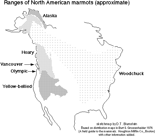
 While driving through Murphy's Hot Springs, ID, we spotted this marmot, likely to be a yellow-bellied marmot, Marmota flaviventris, according to this distribution map.
 And then we took the grade out of the canyon of the East Fork of the Jarbidge River, getting a nice view of the canyon with the Jarbidge Mountains in the background. That's all Cougar Point Tuff in the canyon walls (Bonnichsen, 1991).
 The rest of our trip on the third day was fairly uneventful saving one more crossing of Salmon Falls Creek at across the one-lane Salmon Falls Dam...
 ...and a nice view of the Thousand Springs area near Wendell, Idaho, just before we crossed the Snake River on old Highway 30 (MSRMaps).
 According to this sign, a lava flow — or more than one? — changed the "geologic structure" of the area, resulting in formation of the many springs.
"Over thousands of years, volcanic activity repeatedly spread lava over the Snake River Plain, slowly forcing the river southward in a great curve. Successive channels of the river and its tributaries were filled with spongy lava, and became both reservoirs and underground conduits, gathering water from far to the northeast. Torrents from one or more of these buried channels burst forth on the opposite canyon wall."I can't vouch for this description, but it sounds plausible, if somewhat general.
 Many hours passed as we drove west to northwest on I-84; we finally came to Baker City, Oregon, and settled into a motel. We then immediately walked over to Barley Brown's Brew Pub. We both had the WFO IPA (Wide *Freaking* Open) and had a taste of the Hot Blonde, which is brewed with jalapeño peppers and went well with the south-of-the-border–style Ceasar salad I had. Highly recommened! Their beers as of more than a year ago.
Trip report to be continued...
Some References:
Bonnichsen, Bill, 1982, The Bruneau-Jarbidge Eruptive Center, Southwestern Idaho, in Bill Bonnichsen, and Roy M. Breckenridge, eds, Cenozoic Geology of Idaho: Idaho Geological Survey Bulletin B-26. p. 237-254.
Bonnichsen, Bill, 1991, Geology of Scenic Jarbidge Canyon Near Murphy Hot Springs, Idaho: Idaho Geological Survey, GeoNote 16, 2 pp.
Bonnichsen, Bill and Jenks, M.D., 1990, Geologic map of the Jarbidge River Wilderness Study Area, Owyhee County, Idaho: U.S. Geological Survey, Map MF-2127, scale 1:50000.
Cathey, Henrietta E, and Nash, Barbara P., 2004, The Cougar Point Tuff: Implications for Thermochemical Zonation and Longevity of High-Temperature, Large-Volume Silicic Magmas of the Miocene Yellowstone Hotspot: Journal of Petrology, v. 45, no. 1, p. 27-58.
Henry, C. D., and Wolff, J. A., 1992, Distinguishing strongly rheomorphic tuffs from extensive silicic lavas: Bulletin of Volcanology, v. 54, no. 3, p. 171-186 (links to abstract).
Starkel, W. A., Bonnichsen, B., Godchaux, M., Boroughs, S., and Wolff, J., 2006,
Far-Travelled High-Grade Ignimbrites or Widespread Generation of Low-d18O Magma? The Problem of the West Bennett Hills, Snake River Plain, ID: American Geophysical Union, Fall Meeting 2006, abstract #V51D-1704.