 One year ago today, the Chinese elm trees on our side street were green and growing. They were cut down last fall, an act of our small town that made me sad for weeks every time I looked out the door. They will grow back as bushes, from the stumps, but may never be the same.
Sunday, May 31, 2009
One Year Ago Today: Elm Trees
One year ago today, the Chinese elm trees on our side street were green and growing. They were cut down last fall, an act of our small town that made me sad for weeks every time I looked out the door. They will grow back as bushes, from the stumps, but may never be the same.Saturday, May 30, 2009
Springtime in the Egan Range
 This is what spring looks like, in a good year, in what some call the "high desert," above 6400 feet in eastern Nevada. (I've heard the term "high desert" applied to Barstow, CA, at below 3000 feet elevation, so I'm quite leery of using it.)
This winter wasn't particularly cold, nor was it particularly wet. The monsoon, however, moved into the area a little early, in May rather than in June or July, and April's official rainfall was above average. I won't get into the technicalities of whether eastern Nevada qualifies as arid or semi-arid, though back when I went to school in the Paleocene, I was taught that much of Nevada is semi-arid steppe rather than arid desert.
 Looking south towards Hercules Gap. The dark things in the background and into the mountains are piñon pine and juniper trees.
 Orange, yellow, and minor red Indian paintbrush, and many other kinds of wildflowers.
 Lupine, of the purple-yellow variety, with mountain mahogany bushes.
 Lupine just east of Piscovitch Summit.
 Looking west towards the Butte Mountains.
 An old cabin.
 Looking northeast, down a side road, back towards the Eagan Range.
 Flowers!
 These pictures were all taken on May 29 in the Egan Range of eastern Nevada. All photos were taken between about 6400 and 7600 feet in elevation, from Hercules Gap to Piscevitch Summit to the junction of Thirty Mile with Highway 50.
This post is a submission to the Carnival of the Arid #5, which is hosted at Coyote Crossing by Chris Clarke.
UPDATE: For other views of the Great Basin Desert in spring to summer, see these two June posts from Wheeler Peak: Wheeler Peak Photos Sets, Spring and Summer 2006-2009 and Friday Field Photos: Tarn It! The elevation is higher, spring comes later, and summer is relatively short.
Friday, May 29, 2009
Field Trip Day 2: Pinson Pit Overview
 After lunch, the two field trip buses took us from Getchell down to Pinson. All 79 of us (more or less) then stood near the edge of the Pinson CX pit and looked in, while a guy who acted like the safety guy went around trying to get us to back away from the edge. Prior to this pit overview, we viewed some posters and examined some nice-looking, high-grade drill core.
The stitched-together photo above looks mostly west: southwest to slightly north of west from left to right. Miscellaneous equipment and things in the pit are related to currently suspended underground development and exploration, and possibly to ongoing dewatering.
 Above, a closer view looking at the north part of the CX pit. The mine dump in the upper right part of the photo is a dump from some old tungsten workings. The upper benches of the pit on the northwest side (right) are in unconsolidated alluvium.
 And this is what it looks like on the next to bottom bench of the CX pit: a geology field trip invasion. Geologists on this kind of field trips do a lot of talking and, for some reason, seem to want to examine rocks when the buses are trying to leave!
 And why did we go down there, besides the fact that it was there? To look at rocks and to argue over features like this one, above: was the feature caused by soft-sediment deformation or by post-lithification structural deformation? Keep in mind that these rocks are Cambrian or Ordovician, that they were around during two orogenies during the Palaeozoic, have been intruded and contact-metamorphosed during the Cretaceous, and were mineralized and subjected to Basin-and-Range extension during the Tertiary. The immediate pit area is cut by so many faults that developing and maintaining the underground workings has been difficult to say the least. Geologists on the trip did not reach an agreement about the origin of the deformation seen at Pinson. Some agreed that the answer might be both: soft-sed and structural.
Scale for that last photo is unclear, but the plants are probably very small ones (smaller than my hand).
Tuesday, May 26, 2009
Field Trip Day 2: Getchell Pit
 Continuing with some recent posts showing photos of a field trip to the Humboldt Range and Osgood Mountains of northwestern to north-central Nevada, here's a stitched together photo of the Getchell pit, a scenic place that we stopped for lunch.
The pit follows the Getchell Fault zone, which overall strikes north-south to NNW and dips about 50 degrees to the northeast in the mine area. Timing of motion on the Getchell Fault is complex to unknown, with sub-horizontal slickensides overprinted by steeply dipping slicks. Gold has been mined primarily from sedimentary rocks of the Cambrian Preble and Ordovician Comus Formations in both the hangingwall and footwall of the fault.
 Dark-colored rocks are mostly unoxidized, strongly carbonaceous sedimentary rocks in the footwall of the Getchell Fault; the light-colored gooey-looking mass in the hangingwall of the fault is oxidized granodiorite that is flowing slowly into the pit.
 This relatively smooth surface in the southern part of the pit shows the fault relatively well. The rocks are probably granodiorite in the footwall of the fault, but I won't swear to it, because we didn't get to check it out. I can imagine that I see sub-horizontal lines in this photo (slickensides?), but again, I don't really know for sure; the sub-vertical lines are probably drip lines from runoff but could conceivably include slickensides.
Reference:
Marlowe, K. E., Wood, K. Y., Loranger, R., Martin, D., Pinguely, R., and Reynolds, M., 2009, Geology, mineralization and exploration of the Getchell and Pinson deposits, Humboldt County, Nevada in Ressel, M. W. (ed.), 2009 Spring Field Trip Guidebook: Diverse Gold Deposits of the Osgood Mountains and Humboldt Range, North-Central Nevada: Geol. Soc. Nevada Special Pub. 49, p.51-61.
Monday, May 25, 2009
Field Trip Day 1: Getting There
Just a few more photos from the western Nevada field trip I went on earlier this month: driving to Reno on Highway 50, then on the bus from Reno to Winnemucca on I-80.
 Wonderful spring flowers just east of Bob Scott Summit, looking south toward some of the snow-capped peaks in the Toquima Range, including Mt. Jefferson, the sixth highest peak in Nevada (sometimes called third).
 Here, I'm headed straight for a large dust storm, which was south of the highway at Fallon, so I missed going through it.
 I'm on the bus, now, passing by one potential thesis area from long ago, on my way to the area I studied. This is Rocky Canyon of the Humboldt Range, with the white cliffs being part of a granitic stock.
Saturday, May 23, 2009
Update from the Lake: Some Birds
I was recently at our lake house for several days, longer than I've been there for - a year? More? While there, I spent a lot of time outdoors, watching birds, doing yardwork, and walking. One thing I noticed: it's finally spring at the lake, as evidenced by robins, which were out hopping around, chirping and singing.
 Robin, standing on a piece of basalt in our front yard.
 White-headed woodpecker going after something in one of our Ponderosa pine trees.
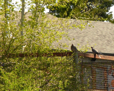
 Hawk or falcon flying overhead, don't know what kind... Do you?
 Band-tailed pigeons that just flew down from a tree to land on someone's deck. I saw one in our yard briefly, as it was leaving.
 House wren hopping about in the front yard. The wren is a very small bird, hardly stands still, is very difficult to photograph. It was very busy checking out everything, including a bird house way too big for it, some small potted evergreen trees, and some hens and chicks.
 Barn swallow on a wire above the cedar walk area. They were flying around, darting quickly in the air, and it was only possible for me to get reasonable photos when they stopped flying. This is the first time I've seen them hanging around in such large numbers.
 A bird in a fir tree, apparently trying to hide from me. Probably a Steller's jay.
 And our tree swallows! Here's a female checking out one of our bird houses.
 The male of the pair, popping his head out of the same nesting box. When they hang on the edge of the hole with their feet and pop their heads out like this, we call them "porpoises" and call the act "porpoising." [Kind of silly, we are sometimes!]
 The same female standing on the box. I don't think they actually nested here, but this may be the same pair that was later building a nest in a bird house in the front yard.
I also saw several other types of birds, including vultures, juncos, chickadees, blackbirds, cowbirds, and a pair of quail.
 Robin, standing on a piece of basalt in our front yard.
 White-headed woodpecker going after something in one of our Ponderosa pine trees.
 Hawk or falcon flying overhead, don't know what kind... Do you?
 Band-tailed pigeons that just flew down from a tree to land on someone's deck. I saw one in our yard briefly, as it was leaving.
 House wren hopping about in the front yard. The wren is a very small bird, hardly stands still, is very difficult to photograph. It was very busy checking out everything, including a bird house way too big for it, some small potted evergreen trees, and some hens and chicks.
 Barn swallow on a wire above the cedar walk area. They were flying around, darting quickly in the air, and it was only possible for me to get reasonable photos when they stopped flying. This is the first time I've seen them hanging around in such large numbers.
 A bird in a fir tree, apparently trying to hide from me. Probably a Steller's jay.
 And our tree swallows! Here's a female checking out one of our bird houses.
 The male of the pair, popping his head out of the same nesting box. When they hang on the edge of the hole with their feet and pop their heads out like this, we call them "porpoises" and call the act "porpoising." [Kind of silly, we are sometimes!]
 The same female standing on the box. I don't think they actually nested here, but this may be the same pair that was later building a nest in a bird house in the front yard.
I also saw several other types of birds, including vultures, juncos, chickadees, blackbirds, cowbirds, and a pair of quail.
Friday, May 22, 2009
Friday Field Photos
 For today's Friday Photos, first we have the above stitched-together photo of the Getchell Mine area (MSRMaps location), looking southwest to west towards the northern part of the Osgood Mountains. I was on a recent geology field trip to the area when I took these photos.
 A head-frame in the distance near the main Getchell mine buildings. Getchell is about 9 kilometers (5.5 miles) north of Pinson.
 And in the foreground, a northeast-trending fault in the Turquoise or Turquoise Ridge pit. Too bad the field trip didn't take us into this pit to look at the fault!
Wednesday, May 20, 2009
Two Years Ago Today: Drilling Inside the Pit

 A couple photos from an early morning visit to an exploration drill rig inside an active mine. The sun was just coming up over the east wall of the pit, about to blind us. Mud on the bench floor is from a water truck passthrough to keep dust under control.
 The pit was busy, as pits often are, with haul trucks going back and forth from the shovel, just in front of the rig. The driller was being annoying because I said to keep drilling. (Hey, it's his job!)
Tuesday, May 19, 2009
Thesis Area Mined!
The Pinson adit, from whence came jasperoid hand samples for my thesis, no longer exists - it was located in the northwest portion of what is now the A Pit of the Pinson Mine, near the bridge area between the A and CX Pits.
 North is up in this air-photo image from a recent field trip to Barrick's Pinson Mine; the scale bar is 1000 feet. This digital photo of the paper image shown on the field trip contains some minor distortion due to operator error (mine!). The air-photo appears to be identical to what you can see on Google Earth, with one exception: Google Earth wraps the air-photo image over older topography, which looks strange when you try to view the existing pits using an oblique angle.
The shed or old barn where the samples were stored is likewise no longer in existence. It was located in the main drainage - Granite Creek - north of the combined A and B Pits, possibly about where the trees or shrubs in the creek are still present. In this MSRMaps map, the shed was located about where the old road crossed Granite Creek. The Pinson Pit in the MSRMaps image is the original, 1980's A Pit [from a map dated 7/1/1988 according to my original link]; the smaller-than-now A Pit is where the adit was located. The adit was put in by the Cordex I Syndicate in the early 1970's, prior to my sample collecting in 1976.
While collecting samples, I stayed at the home of Fred and Dorothy Barnes on the site of the then inactive Getchell Mine, in a house that is probably not there anymore. In order to call their house, you had to get an operator to ring Getchell #1 or Getchell #2. From outside Nevada, one of the last states using toll stations or ring downs (into at least the mid 1980's - or early 1990's?), you had to tell the operator to put you through to a Nevada operator. Out-of-state operators generally didn't believe numbers such as Midas #2 and Coaldale #1 still existed, and would insist that you give them an area code and a 7-digit phone number.
Tuesday, May 12, 2009
Hummingbird Moth
These photos of a white-lined sphinx moth, or hummingbird moth - Hyles lineata - were taken right along Highway 95, between Goldfield and Beatty, Nevada, on our recent trip to the Mojave Desert via Titus Canyon. I didn't mark the exact location of these photos, but the elevation is about 4700 feet.
We were lucky to have fairly low temps throughout our 5-day trip - which is good, because my truck doesn't have air-conditioning. Low, in this case, means anything under 95 to 100° F.
 We stopped because of the wildflowers, which were spectacular in places, even though we missed the main show. The moth was sipping evening nectar from some Prince's plume: Stanleya pinnata.
 And here's the moth! When first seeing these moths, one is often inclined to think they are small hummingbirds. They hover just like hummingbirds, make a humming or buzzing sound while flying, and dart around very quickly.
 The wings are brightly colored, though it's difficult to get them to sit still long enough for perfect photos!
 As you can see, they hover over the target flower, and suck nectar through a long proboscis, which is essentially a tubular tongue.
 Their wings are usually just a blur, and in this photo the proboscis is coiled.
Photos: May 1, 2009.
Monday, May 11, 2009
A Twit Wordle
 Here's a Wordle of all my tweets so far on twitter. The Wordle was made at Wordle.com, which used a Tweet Cloud made by TweetStats. I'll just give you the home pages so you can create your own Tweet Wordles, if you want to, rather than linking to my stats. As usual, you can play around with colors and fonts, and generally waste as many hours as you'd like!
These are the sorts of things I do when I don't feel the pressing need to do other things! And these are the sorts of reasons I'm behind on blog reading, blog writing, commenting, and even downloading photos from my camera! Oh, well...
Thursday, May 7, 2009
Tweeting the Eureka Quartzite

Eureka Quartzite, with cave, on a hill above Ely, NV
A Geological Conversation, on Twitter, about the Eureka Quartzite (April):
aboutgeology: @sfoxx OK, why is the Eureka Qtzite such a familiar name? What's it signify? 7:02 PM
sfoxx: @aboutgeology It's an unusual siliclastic break in the middle of the Ordovician in an otherwise carbonate depositional environment. Eustacy. 7:03 PM
sfoxx: @aboutgeology Actually, it's a very nice marker horizon, a very pretty rock, and quite widespread in central and eastern Nevada! 7:04 PM
sfoxx: @aboutgeology Have you written about the Eureka Qtzite? 7:06 PM
clasticdetritus: @sfoxx @aboutgeology re Eureka Qtzt - and an extremely important stratigraphic marker in the region too, if I remember correctly 7:07 PM
clasticdetritus: @aboutgeology @sfoxx re Eureka -- doh, sfoxx, you just said that before I did ... need to read other tweets before tweeting 7:08 PM
sfoxx: @clasticdetritus @aboutgeology Very important. And I've been reading it may have correlations into Mexico, and even on the east coast 7:10 PM
sfoxx: @clasticdetritus Oh, well! :) 7:10 PM
sfoxx: @clasticdetritus There have been a bunch of conodont studies in the rx above and below the Oe; it seems to be bounded by unconformities. 7:13 PM
rschott: @sfoxx Just how metamorphosed is the Eureka Quartzite? Is it truly a quartzite or just a quartz arenite? Maybe even friable? 7:16 PM
sfoxx: @rschott It's totally non-friable, except maybe in places near the bottom, though I've never seen it that way. May be an orthoqtzite. 7:32 PM
aboutgeology: So it's a big, clean quartzite in the middle of a fat Ordovician carbonate sequence. A pulse of stored sand? What's its provenance? 7:33 PM
aboutgeology: With unconforms above and below? Is it involved in thrusting as a coherent block? 7:37 PM
rschott: @aboutgeology @sfoxx Any idea when it was metamorphosed? Are the carbonates above and below it marbles? Gotta collect me some! Roadtrip! 7:37 PM
sfoxx: @aboutgeology @rschott I read just now that the source is the Peace River Arch in B.C. http://tr.im/iH8m 7:38 PM
sfoxx: @rschott @aboutgeology Gee Whiz! Yes, come get some. It should be in the upper plate of the Roberts Mountain thrust. Below overlap sequence. 7:40 PM
rschott: @sfoxx @aboutgeology A-ha, I figured George Gehrels would have done some detrital zircon work on it. Neat stuff! 7:41 PM
sfoxx: @rschott @aboutgeology When? Ortho - soon after depn? Un/dis conformities are regional, not always obvious in otcp. (I didn't notice!) 7:42 PM
aboutgeology: @sfoxx That talk says no, the Peace R Arch zircs are supplemented by local zircs in Idaho and NMex. 7:42 PM
aboutgeology: Ordovician paleogeography: http://tinyurl.com/ctg5dq 7:44 PM
sfoxx: A very nice rock, you all-everyone-should have some. The Oe above my house here is almost completely bx'd and changes thickness rapidly. 7:45 PM
sfoxx: @aboutgeology So it has a source to the north, but then local sources as well 7:46 PM
aboutgeology: @sfoxx Do you have a photo up of the Oe? 7:48 PM
sfoxx: @aboutgeology Oh, okay, they were finding new evidence from the long-standing Peace R Arch idea. 7:48 PM
aboutgeology: @sfoxx So the zircs point to a regional, Cordilleran pulse of unroofing, not just one Canadian arch? 7:50 PM
sfoxx: I have a couple pics of the Oe @aboutgeology @rschott This one: http://tr.im/icoX And this old one, mostly a fault: http://tr.im/iHac 7:52 PM
aboutgeology: Aha, not orogeny but eustasy given East US equivs: http://tinyurl.com/ch3tkk 7:53 PM
aboutgeology: @sfoxx Pretty pix! A clean, massive qtzt. Is it distinctive in hand specimen? 7:55 PM
sfoxx: @aboutgeology Exactly, which is why there may be a correlation to other siliclastics on the east coast, although I don't have the ref handy. 7:56 PM
sfoxx: @aboutgeology It's generally distinctive from the Prospect Mtn Qtzite in being much cleaner, lighter. And there aren't v. many others. 7:58 PM
sfoxx: @aboutgeology Actually, that last abstract you cited was the ref I was thinking of! 8:00 PM
sfoxx: I have some great photos of the type section, type area of the Eureka Quartzite! It's right on Highway 50 west of Eureka a ways. 8:02 PM
sfoxx: @aboutgeology The Oe rt above our house has an interesting arch in it, from erosion along the intersection of high&low angle fault-joints 8:17 PM
aboutgeology: @sfoxx No wonder there's no type section, it was named in 1883: Geolex - http://tinyurl.com/dhhvym 8:20 PM
sfoxx: @aboutgeology It had a broad type area, which was redefined to Lone Mountain in 1956 by Nolan [no, by Kirk in 1933]. I think that's the defacto "type section." 8:23 PM
sfoxx: Nolan et al, 1956: http://pubs.er.usgs.gov/usgspubs/pp/pp276 8:25 PM
clasticdetritus: @rschott @aboutgeology @sfoxx re Oe -- dang, you guys did some serious tweetsearch ... I need to catch up! 8:34 PM
sfoxx: @clasticdetritus Tweetsearch, I like that. I had been doing some research off and on during the day, @aboutgeology does research v. fast! 8:37 PM
rschott: @aboutgeology @sfoxx @clasticdetritus The Eureka Quartzite discussion is a prime example of how Twitter can be genuinely useful for geology. 8:37 PM
sfoxx: @rschott Tweetsearch, @clasticdetritus called it! 8:39 PM
Reference:
Kirk, Edwin, 1933, The Eureka quartzite of the Great Basin region: Am. Jour. Sci, 5th ser., v. 26, p. 27-44.
The GeoTweeters:
@aboutgeology
@clasticdetritus
@rschott
@sfoxx
Wednesday, May 6, 2009
Carnival of the Arid #4 is Up! - and Titus Canyon
Chris Clarke posted the fourth Carnival of the Arid over at Coyote Crossing while I was away on a field trip to the Mojave Desert. This fourth edition of CotA is excellent, so please be sure to visit, read, and enjoy.
 Speaking of the desert, here's a photo of a smallish lizard sunning itself on some limestone breccia near an old mining shack at Leadfield, in Titus Canyon, Death Valley, CA. I don't know what kind of lizard this is, but the body couldn't have been more than two inches in length.


 Speaking of the desert, here's a photo of a smallish lizard sunning itself on some limestone breccia near an old mining shack at Leadfield, in Titus Canyon, Death Valley, CA. I don't know what kind of lizard this is, but the body couldn't have been more than two inches in length.
Cambrian limestone beds forming the walls of Titus Canyon.
As for Titus Canyon, here are two quick photos taken not far below Leadfield. The first photo, above, was taken just above the location where Ron Schott created this QTVR image/photo. In fact, some of the same beds are visible in both the photo above and in his image!
The canyon narrows after entering Titus Canyon proper.
This second photo, taken a little ways downstream of the first photo, shows the general demeanor of the canyon before it narrows and becomes more of a slot canyon.The Titus Canyon road is a one-way rocky and washboardy dirt road into Death Valley. Pulling over and passing other vehicles is not possible in some places, which is why it's a one-way road. We decided that much of it could be driven by the Prius (very slowly), but one or two parts require higher clearance than most small cars manage to muster. I recommend a high-clearance vehicle (I scraped once when diverted by the spectacular scenery), and 4WD isn't a bad thing, either.
Subscribe to:
Posts (Atom)