A River Runs through It [link to download], ESW 2016, E-59 NBMG: Truckee River Reno to Pyramid Lake
1915 Pleasant Valley earthquake centennial field trip guidebook: A public field trip to visit the largest earthquake in Nevada's history [link to download] E-58 NBMG: 50 miles south of Winnemucca
Fire and Ice—Geology of the Mount Rose quadrangle, Lake Tahoe, and the Carson Range [link to download pdf], ESW 2015, E-57 NBMG: Galena Creek Visitor Center to Incline Village
Carson Rocks! A Sesquicentennial Celebration of some of our Capital City's Geological High Points [link to download pdf], ESW 2014, E-56 NBMG: around Carson City
Geo- and Eco-Mapping around DRI (The Great Altered Rock Walking Tour) [link download pdf], 2014, E-55, NBMG: around DRI.
Mapping the Geology around the Desert Research Institute and Truckee Meadows Community College [pdf], ESW 2013, E-53, NBMG: around DRI.
"Tuff All Over": Exploring Faulted Volcanic Terrain in the Painted Hills, Virginia Mountains, West of Pyramid Lake [pdf], ESW 2012, E-52, NBMG: near Pyramid Lake.
"Life's a Beach": In Search of Ancient Shorelines and Volcanoes in the Grimes Point and Lahontan Mountains Area [pdf], ESW 2011, E-51, NBMG: near Fallon.
Geo-tripping in Nevada [pdf], NBMG map guide to many or most of the NBMG field trip guides in Nevada through E-50.
In search of Tufa, Tuff, and Tough Rocks [link to download pdf], ESW 2010, E-50, NBMG: stops are east of Pyramid Lake; trip guide includes Reno to Pyramid Lake, Pyramid Lake to Wadsworth, Pyramid Lake to Brady's Hot Springs, Brady's Hot Springs to Reno.
Digging Deeper into the Comstock [link to download pdf], ESW 2009, E-48, NBMG: Reno to Gold Hill.
No Child Left Inside: A field trip for Families and Rockhounds [link to download pdf], ESW 2008, E-47, NBMG: stops are near Fallon, east of Fallon, north of Fallon, and in the Truckee River Canyon along I-80; road guide runs from Reno to east of Fallon, Fallon to Trinity (junction of I-80 and 95), and Trinity to Reno.
Taking the Pulse of the Earth [link to download pdf], ESW 2007, E-46, NBMG: south of Reno (Slide Mountain, Steamboat, and Virginia Foothills; the latter two not available to public).
Rockin' Along the River [link to download pdf], ESW 2006, E-45 NMBG: Truckee River Verdi to Wadsworth
The great Highway 50 rock tour [link to download], ESW 2005, E-44 NBMG: Fallon to Middlegate
The Frenchman lake frolic [link to download], ESW 2004, E-43 NBMG: Frenchman Lake area, California, west of NV-CA border.
Get out, stay out, and stay alive [link to download], ESW 2003, E-42 NBMG: north of Reno towards Pyramid Lake.
In search of "the right tuff" but you can just "take it for granite" [link to download], ESW 2002, E-41 NBMG: north of Reno and to the west toward northern end of Red Rock Road.
Fossils and Ancient Lakes [link to download pdf], ESW 2001 field trip #2, E-40, NBMG: fossils near Nightingale.
Peavine Peak: Geology, plants, and mining history [link to download], ESW 2001 field trip #1, E-39, NBMG: Peavine.
Exploring east of the summit: A field trip guide to Steamboat Springs, Lake Tahoe, and the Comstock area [link to download pdf], ESW 2000, E-38 NBMG: Steamboat Springs, Lake Tahoe, Comstock.
Geology along America's loneliest highway [link to download pdf], ESW 2000 E-37 NBMG: Carson to Sand Mountain.
What's shakin' in the neighborhood? -- Road log [link to download pdf], ESW 1999 field trip #2, E-34 NBMG: Reno, Mt. Rose fan/pediment, to Genoa fault scarp.
Turbulent times in the Truckee Meadows [link to download pdf], ESW 1999 field trip #1, E-33 NBMG: UNR to Verdi to Crystal Peak Mine.
Ancient lakes and volcanoes near Fallon: Field trip for families and rockhounds [link to download pdf], ESW 1998, E-28 NBMG: Fallon, Grimes Point, Soda Lake.
Link to NBMG's entire Educational series; most (all?) are available to download.
INQUA 2003 - Elko to Reno, Wadsworth Amp, Lone Mtn hwy 50, Reheis - no viewing online at Google books
Geothermal energy helps power Nevada | Elko Daily Free Press - Brady's Hot Spring, Beowawe, and "Hot Hole" in Elko
The Stories Behind I-80s Exit Sign Names - Part 1 | Backyard Traveler by Rich Moreno - various info about signs and areas, e.g., Nightingale and Brady's Hot Springs
Touring California and Nevada hot springs | Matt C. Bischoff - Brady's Hot Springs reaches 209*F (and other tidbits)
Showing posts with label links. Show all posts
Showing posts with label links. Show all posts
Friday, March 23, 2018


Sunday, November 27, 2016
Links: Here Are a Few, But Great, Great Basin and Great Basin Divide Links

Quaternary stratigraphic, hydrologic, and climatic history of the Great Basin, with emphasis on Lakes Lahontan, Bonneville, and Tecopa - Morrison, cited in the first ref, said the area of the GB "exceeds 500,000 square kilometers" ; this source is not available online, is part of DNAG - this volume.
The Great Basin: A Natural Prehistory - Grayson, at Amazon. (and here's a Google Book preview.) A better map of the GB. Grayson discounts having the Salton Sea in the Great Basin on page 11. His map, page 12, also ends the Great Basin in Pahranagat Lake, as justified below (Witt etal, 2008):
Jonathan D.S. Witt, Doug L. Threloff, and Paul D.N. Hebert -
Genetic zoogeography of the Hyalella azteca species complex in the Great Basin: Rapid rates of molecular diversification in desert springs:
Geological Society of America Special Papers, 2008, 439, p. 103-114, doi:10.1130/2008.2439(05). Page 104 (clip from Google Books):

Late Cenozoic Drainage History of the Southwestern Great Basin and Lower Colorado River Region: Geologic and Biotic Perspectives -
edited by Marith C. Reheis, Robert Hershler and David M. Miller).
Fishes of the Great Basin - a Google Books preview - shows the White River above the lower end of Pahranagat Valley as in Great Basin.
 |
| Google Earth image of the West with a lot of lines. The Great Basin divide according to me is in magenta, wrapping around the Great Basin. Note the two possibilities at Pahranagat Lake, and no Salton Sea. |
The Jarbidge Mining District, 1923 - mentions the GBD.
Location:
The Great Basin, USA
Sunday, November 20, 2016
Links: The Sump, Nevada

While trying to figure out if The Sump would be a stop along the way or the way back (it wasn't), I collected a few links. Most of the links show only one picture from the place; a few show more. I'll leave it to you to do more investigation (and visitation, I hope!). The links are listed rather randomly. Links about the fossils, in particular, are at the bottom.
The "Sump"—Strange Name but Amazing Place - Backyard Traveler by Richard Moreno
The Sump, Esmeralda County, Nevada - Eastern Mojave Vegetation (schweich.com)
The Sump Canyon paradise - Terry's World (Terry Wright, geologist)
The Sump (Esmeralda County, Nevada) - Weekend Wanderluster
The Fossils:
Hardy, F.C., and Bonde, J., 2015, Stomping Around the Sump: Miocene Pygmy Gomphothere from Esmeralda County, Nevada [also here], in Pennell, W.M., and Garside, L.J., eds., New Concepts and Discoveries: GSN 2015 Symposium Proceedings: Geological Society of Nevada, p. 929-937.
Sand and Bone - a photo slide show (in color): "Go along with a band of UNLV researchers as they uncover the skull of an extinct elephant-like creature that once roamed Esmeralda County."
Photo Essay: In the Footsteps of the Elephant - VegasSeven (really nice B&W photos)
Sunday, November 13, 2016
Links: Auriferous Gravels in CA
 |
| Here are a few links about the Au-bearing gravels of the California foothills and Sierra Nevada. (It's time to get this out of my drafts folder.) |
Garside, Larry J., Henry, Christopher D., Faulds, James E., and Hinz, Nicholas H., 2005, The Upper Reaches of the Sierra Nevada Auriferous Gold Channels, California and Nevada, in Rhoden, H.N., Steininger, R.C., and Vikre, P. G., eds., Geological Society of Nevada Symposium 2005: Window to the World, Reno, Nevada, May 2005, p. 209-236.
Yeend, W.E., 1974, Gold-bearing gravel of the ancestral Yuba River, Sierra Nevada, California: U.S. Geological Survey Prof. Paper 772, 44 p., Plate 1 and Plate 2.
Friday, January 29, 2016
Links: Pumice and Pumicite

Chesterman, C.W., 1956, Pumice, pumicite, and volcanic cinders in California and Technology of pumice, pumicite, and volcanic cinders [pdf; text]: CDMG Bulletin 174, 119 p.
Presley, G.C., 2006, Pumice, pumicite, and volcanic cinder, in Kogel, J.E., Trivedi, N.C., Barker, J.M., and Krukowski, S.T., eds., Industrial rocks and minerals (7th ed.): Littleton, CO, Society for Mining, Metallurgy, and Exploration, Inc., p. 743–754.
Pumice and Pumicite Statistics and Information - USGS links and reports.
What is the fate of the pumice rafts? (2012) - at Eruptions.
Pumice flows (down the page), a type of pyroclastic flow - at SDSU.
Pumice - at MEC.
Pumice - at Minerals Zone.
Pumice - at Sandatlas.
Pumice - at Volcano Discovery.
Tuesday, November 24, 2015
Views from Glass Mountain

Above, my rock hammer is in front of blocks of relatively light-colored, vesiculated, rhyolite obsidian (AKA pumice, but in this case it's pumiceous flow-rock, not tephra).
Before I get to a few views of the area, I'll go into the geology just a little:
 |
| Julie Donnelly-Nolan points to her map of the Glass Mountain dacite-rhyolite flow, Siskiyou County, CA. |
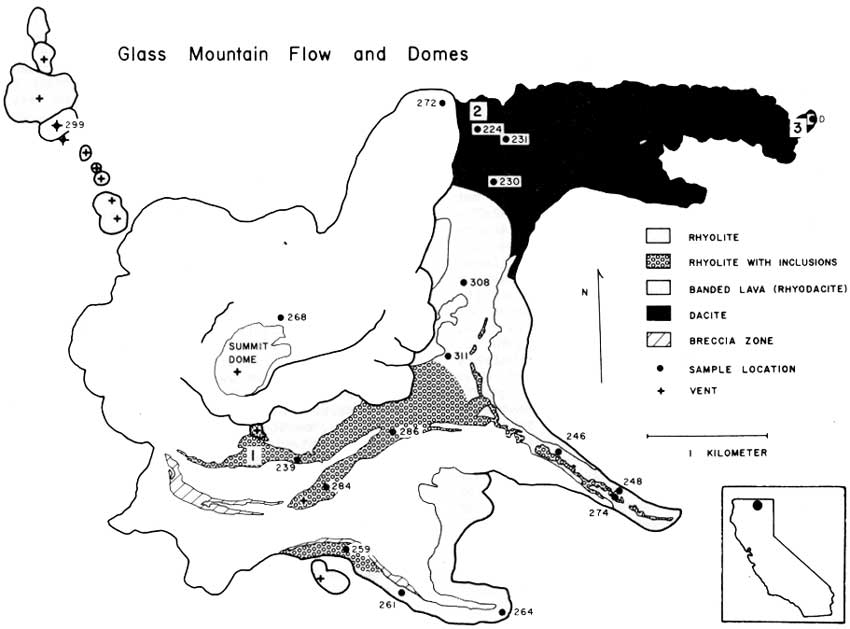
As you can see below in a rotated version of the map, the Glass Mountain dacite-rhyolite flow "consists of three dacitic eastern lobes which grade westward to rhyolite and are overlain by rhyolite lobes" (Donnelly-Nolan et al., 1981, and in Coyner, 2015). Well, maybe not all of that is obvious at first glance, but read on.
 |
| Map showing the silica content of different parts of the Glass Mountain dacite-rhyolite flow (Donnelly-Nolan, unpublished). North is up. |
On the map, the highest silica parts of the flow, the rhyolite, are in orange; the parts of the flow with lowest silica content, the dacite, are in purple; the areas with silica content in between rhyolite and dacite, essentially rhyodacite, are in red. NOTE: Though by many classification schemes the silica content of rhyolite is about 68 or 69% and higher (the USGS appears to be using two different cutoffs), and the silica content of dacite ranges from about 63-68% or 69%; TAS diagrams show dacite compositions as high as 72-75% (depending on what version of TAS one happens to choose; here's one; TAS explained here and here; and a lot more about the classification of igneous rocks—including all kinds of diagrams, references, and a flow chart—can be perused here). Rhyodacite is a term generally used for rock composisitons between rhyolite and dacite (USGS, OSU), rather than a specific field in most classification systems.
The colorful map (I love color!) shows that the lithologic composition of the overall flow, which is thought to have erupted during the course of several or many days or weeks rather than over several months or years, is quite variable. The complexities of magma mixing and eruption to produce this variability are described by Eichelberger (1975, 1981). Basically, it's complicated: first, basalt intrudes a rhyolite magma chamber; then mixing creates rhyodacite and dacite, which float to the top of the chamber in his eruption scenario; eruption, triggered by the mixing, produces dacite, then rhyodacite, then rhyolite.
Below, I decided to see what kind of map I would come up with going mostly by color and topographic expression of the flows (with a lot of help from Julie's map).
 |
| Google Earth image of the Glass Mountain dacite-rhyolite flow. |
 |
| Here, I've delineated the dark areas with purple lines, the light, viscous, and some banded areas with orange lines, and the in between areas with red lines. |
 |
| I've added some colorful fill to facilitate comparison to the geologic map. |
 |
| Here's the rotated map again (and it's skewed). |
Well, that was really a kind of long aside, almost like a post within a post!
Besides hanging around the map and hefting large rocks, the view from the east side of the rhyolite flow (see our location below the post) was good—not great simply because of the low-hanging clouds that hadn't lifted.
 |
| Photo looking south. |
 |
| Photo looking nearly due east. |
Oh, and btw, the Glass Mountain flow erupted about 900 years ago: it has a calibrated radiocarbon age of 890 BP (Donnelly-Nolan et al., 2007).
 |
| With the blocky rocks of the dacite flow lobe in the foreground, we look northeasterly in this photo. That's probably Double Head Mountain just left of center; the north edge of Timber Mountain is on the far right. |
A Few References:
A Web Browser Flow Chart for the Classification of Igneous Rocks - a lot of info (largely from Le Bas and Streckeisen, 1999, and other related sources), and a flow chart
Tephra and Volcaniclastic Rocks - good overall classification scheme, though it doesn't reference any primary sources, and allows agglutinate to occur only in basaltic rocks
Coyner, Alan (ed.), 2015, Geological Society of Nevada 2015 fall field trip guidebook: Geology of the Far Northwestern Great Basin: Quartz Mountain gold deposit, Oregon, and Lava Beds National Monument and Glass Mountain Pumice Deposit, California [for sale here, but not yet listed]: Geological Society of Nevada, Special Publication No. 60, 71 p.
Donnelly-Nolan, J. M., 2010, Geologic map of Medicine Lake Volcano, Northern California: U.S. Geological Survey Scientific Investigations Map 2927, scale 1:50,000, Sheet 1 and Sheet 2, Pamphlet to accompany the map, 48p.
Donnelly-Nolan, J.M., Ciancanelli, E.V., Eichelberger, J.C., Fink, J.H., Heiken, Grant, 1981, Roadlog for field trip to Medicine Lake Highland. in Johnson, D., and Donnelly-Nolan, J., eds., Guides to some volcanic terranes in Washington, Idaho, Oregon, and northern California: U.S. Geological Survey Circular 838, p. 141–149.
Donnelly-Nolan, J. M., Nathenson, M., Champion, D. E., Ramsey, D. W., Lowenstern, J. B. & Ewert, J. W., 2007, Volcano hazards assessment for Medicine Lake Volcano, Northern California: U.S.Geological Survey Scientific Investigations Report, 2007-5174-A, 26 p
Eichelberger, J.C., 1975, Origin of andesite and dacite: Evidence of mixing at Glass Mountain in California and at other circum-Pacific volcanoes: Geological Society America Bulletin 86, v. 10, p 1381-1391.
Eichelberger, J.C., 1981, Mechanism of magma mixing at Glass Mountain, Medicine Lake Highland volcano, California, in Johnson, D., and Donnelly-Nolan, J., eds., Guides to some volcanic terranes in Washington, Idaho, Oregon, and northern California: U.S. Geological Survey Circular 838, p. 183-189.
jpg of lava chemistry figure (Eichelberger, 1981)
Hildreth, Wes, 1981, David Alexander Johnston, 1949-1980, in Johnson, D., and Donnelly-Nolan, J., eds., Guides to some volcanic terranes in Washington, Idaho, Oregon, and northern California: U.S. Geological Survey Circular 838, p. viii-x.
Johnston, D.A., and Donnelly-Nolan, J.M., 1981, Guides to Some Volcanic Terranes in Washington, Idaho, Oregon, and Northern California [pdf version; also here in html]: U.S. Geological Survey Circular 838, 189 p.
Tuesday, November 10, 2015
Links: Field Tests for Gold and Silver (or other Elements or Metals, and Sometimes Minerals)
After reviewing links on my 2009 blowpipe tests post (spurred on by this recent comment on another post), I decided to do a little more research concerning field tests for gold, silver, and other metals (primarily; some of these links are for minerals in general, though I haven't included links for the usual hardness, scratch, and other well-known tests and characteristics). The articles and books listed below may include information about blow-pipe tests (B) or info about other types of tests (O). Some include general gold, silver, and other metal or mineral prospecting information (P), many include information about other metals or elements besides gold and silver (ME), a few include info about minerals, not just elements (M), and a couple are more unknown in their coverage because they are not available in full online (U). I've listed them by year.
Merritt, W.H., 1911, Field Testing for Gold and Silver: A Practical Manual for Prospectors and Miners: Crosby Lockwood and Son, London. (B, O, P)
Osborn, H.S. and Von Bernewitz, M.W., 1920, Prospector's Field Book and Guide: Henry Cary Baird & Co., Inc., New York. (B, O, P, ME, M)
Davison, E. H., 1937. Field tests for minerals [snippet view only]. London: Chapman & Hall. (M, U)
Fansett, G.R., 1940, Field Tests for the Common Metals: Arizona Bureau of Mines Bull. 147. (B, O, P, ME)
Stevens, R. E., and Carton, M. K., 1948, Simple field test for distinguishing minerals by abrasion pH: American Mineralogist, v.33, p. 31-50. (O, M)
Roseveare, G.H., 1966, Field Tests for the Common Mineral Elements: Arizona Bureau of Mines Bull 175. [this appears to be a reprint or update of ABM Bulletin 147 linked above] (B, O, P, ME)
Franke, W.A., (no date, prob 1990s), Quick assays in mineral identification, A guide to experiments for mineral collectors and geoscientists in field work. Published online. (B, O, ME)
Pray, R.E., 2006, How to Prospect for Silver Field Tests You Can Use to Detect the Hidden Metal [abs only, or subscription required]: ICMJ's Prospecting and Mining Journal (P, U)
Basic Field Tests for Gold and Various other Metals - at Nevada Outback Gems (O, P, ME)
And of course there now is portable or handheld xrf. This is my favorite model (although I've used only two models from one manufacturer).
Merritt, W.H., 1911, Field Testing for Gold and Silver: A Practical Manual for Prospectors and Miners: Crosby Lockwood and Son, London. (B, O, P)
Osborn, H.S. and Von Bernewitz, M.W., 1920, Prospector's Field Book and Guide: Henry Cary Baird & Co., Inc., New York. (B, O, P, ME, M)
Davison, E. H., 1937. Field tests for minerals [snippet view only]. London: Chapman & Hall. (M, U)
Fansett, G.R., 1940, Field Tests for the Common Metals: Arizona Bureau of Mines Bull. 147. (B, O, P, ME)
Stevens, R. E., and Carton, M. K., 1948, Simple field test for distinguishing minerals by abrasion pH: American Mineralogist, v.33, p. 31-50. (O, M)
Roseveare, G.H., 1966, Field Tests for the Common Mineral Elements: Arizona Bureau of Mines Bull 175. [this appears to be a reprint or update of ABM Bulletin 147 linked above] (B, O, P, ME)
Franke, W.A., (no date, prob 1990s), Quick assays in mineral identification, A guide to experiments for mineral collectors and geoscientists in field work. Published online. (B, O, ME)
Pray, R.E., 2006, How to Prospect for Silver Field Tests You Can Use to Detect the Hidden Metal [abs only, or subscription required]: ICMJ's Prospecting and Mining Journal (P, U)
Basic Field Tests for Gold and Various other Metals - at Nevada Outback Gems (O, P, ME)
And of course there now is portable or handheld xrf. This is my favorite model (although I've used only two models from one manufacturer).
Thursday, November 5, 2015
Links: Nevada Highway 8A
 |
| 8A sign taken by yours truly in 2015 |
Photos:
"Jim Stolpa" (1993) - photo of "of NV Road 8A where Jim Stolpa..." by Acey Harper Pictures on Getty Images
"NV-8A East - Nevada State Line" - Flickr photo taken Oct 2006, by Zach
"NV-8A East - Travel At Your Own Risk" - Flickr photo taken Oct 2006, by Zach
Trip & Pics Part Two - Antelope, Wild Horses, Ruby Pipeline, Remote Nevada (2011) - mention and pics of 8A (and the Stolpas) in a travel blog post
Steep and Rocky's Black Rock Desert Ride (2012) - mention and pic(s) of 8A on page 2 at Adventure Rider (motorcycle trips)
"Route 8A Near Vya, Nevada" - Flickr photo taken Nov 2013, by Ken Lund
"Route 8A Near Massacre Lake and Vya, Nevada" - Flickr photo taken Nov 2013, by Ken Lund
Various Links for 8A in NW Nevada:
Gateway Communities - Cedarville, via 8A, is the "western gateway to the High Rock country"
Camping, BLM California - Applegate Field Office - directions using 8A
Nevada RV Parks & Campgrounds - The Happy Camper Club - directions to Old Yella Dog Ranch via 8A
U.S. 395 route in CA - Facebook post - mentions 8A at the CA-NV stateline
Sherriff's Office investigates fatal accident in northern Washoe County - This is Reno - occurred on S.R. 8A
Lost fire update at Inciweb - NV S.R. 34 closed at S.R. 8A
News about the Lost fire at YubaNet.com - updates on NV S.R. 34 and 8A
Nevada State Route 8A at Rediff - "Former State Route 8A...signs remain...still de facto connects SR 140 with California."
Nevada lawmakers avoid tax fairness issue - mention of routes 8A and 34
Google Groups discussion about Highway 140 - mention of 8A
Various Links for 8A in Central Nevada:
District Attorney Presses for Charges in Slaying Case - archive from 1955; mention of 8A north of Carvers in Big Smoky Valley
Nevada State Journal article (1963) - "The 65 mile project will run east from Tonopah to State Route 8A junction."
Placer Gold Deposits of Nevada - USGS Bull 1356 (1973) - p. 36, 42, 62, 65: access to prospects/properties near Battle Mountain and Tonopah
A History of Smoky Valley, Nevada (1997) - see Chapter 20, about Carvers
Growing Up in Central Nevada 1941-1959 (2010) - mention of 8A in a memoir
Various Real Estate Listings on 8A:
Several near Vya (listed as Gerlach)
Near or in Battle Mountain
NOTE: There are more of these; particular listings may not remain active!
Stolpa Links mentioning 8A:
Family Rescued After Being Lost in Snow for a Week : Storm: Soldier walks for help after leaving his wife and baby in a cave. All three are in good condition. - LATimes, January 7, 1993
Family Survives Western Storms After Spending 4 Snowbound Days In Cave - Chicago Tribune, January 7, 1993
Travelers On 'Road To Nowhere' Wonder How Family Survived - Orlando Sentinel, January 10, 1993
Stranded family recounts ordeal - The Baltimore Sun, January 8, 1993
Staying Alive: Stranded Nine Days in a Snowy Nevada Wasteland, a Brave Young Family Survives on Faith, Love, Grit—and a Little Basic Training - People.com, February 8, 1993
The travails of a treacherous trip - Tahoe Daily Tribune, December 13, 2004
I should not be alive… (2006) - Blog post at Mrudulat's Blog
Inspiring True Stories Of Survival. - 2008 forum at Stormfront.org
The Stolpa family, marooned east of Vya, 1993 - 2011 forum at Wander The West
Anyone Remember this Story? - 2012 forum at Houzz
Soldier walks for help after leaving his wife and baby in a cave - July 22, 2014 blog post on tttracy's blog
Santa Cruz Sentinel article (1993) - "It began to seem like the end of the world for the Stolpa family when no other vehicles appeared on Washoe County road 8A."
Stolpa Truck Location kmz location on 8A, Google Earth
NOTE: Many dead links (11Jun22)
Monday, June 1, 2015
The Beginning of an El Niño Trip: North-Central and Western Nevada
An El Niño has supposedly set in (starting when, exactly, I'm not sure). And if precipitation continues to be anything like it has been during the last several weeks, I hope it's here for the the long haul, that is, into the winter.
March 2015 ENSO discussion: El Niño is here
NOAA, March 5th.
Scientists Suggest a Strong El Nino Is Possible. Why Should You Care?
The Weather Channel, May 14th.
El Nino Delivers Drought-Busting but Flooding Rain to Texas; California May be Next
AccuWeather.com, May 19th.
With El Niño likely, what climate impacts are favored for this summer?
NOAA, May 28th.
 |
| Rain shower in the northern part of the East Range near Winnemucca, NV, looking SW. Photo taken May 17th, 12:03 pm. The highest, roundish mass on the left is probably Dun Glen Peak. |
 |
| Rain showers in the Eugene Mountains to the east of the East Range, looking west. Photo taken May 17th, 12:10 pm. |
 |
| The low hills of the southern Pah Rah Range, as seen from the JA Nugget, looking NE. Photo taken May 17th, 4:35 pm. |
NOAA, March 5th.
Scientists Suggest a Strong El Nino Is Possible. Why Should You Care?
The Weather Channel, May 14th.
El Nino Delivers Drought-Busting but Flooding Rain to Texas; California May be Next
AccuWeather.com, May 19th.
With El Niño likely, what climate impacts are favored for this summer?
NOAA, May 28th.
Monday, January 12, 2015
2014 Top Ten Posts at LFD...
...and, like last year and the year before, a few more. And to quote paraphrase myself from last year:
January:

February:
March:

April:
.JPG)
May:

June:

July:

August:

September:
October:

November:

December:

And so, the top 10 posts, plus 14 extra, along with a few pretty pictures:Because of the vagaries of stat reporting (in this case, by Google Analytics), I'm listing both the top ten posts for the year (in large font, with respective Top Ten number), and the toptwoone or two posts for every month (non-ten-rated posts are in a smaller font).
January:
- De-Icing at the Anchorage Airport #5
- Where in the West: Dean and Burke Channels; Thunder Mountain and Tzeetsaytsul Peak, B.C. #6
February:
- New Snow in North-Central Nevada (my only post for February!!)
March:
April:
May:
June:
July:
August:
September:
October:
November:
December:
Thursday, December 4, 2014
Links: Lamoille Canyon Geology
Geologic Map of the Ruby Mountains, Nevada - USGS Map I-1136 (Howard, Kistler, Snoke, and Willden, 1979)
Geologic Map of the Lamoille Quadrangle, Elko County, Nevada - NBMG Map 125 (Howard, 2000)
Geology of the Lamoille Quadrangle, Elko County, Nevada - text for Map 125 (Howard, 2000)
Lamoille canyon nappe in the Ruby Mountains metamorphic core complex, Nevada - GSA, Cordilleran Section, DNAG, Centennial Field Guide, v. 1 (Howard, 1987)
New investigations of Pleistocene glacial and pluvial records in northeastern Nevada; Day 3: Elko to Logan: The Lamoille Type Locality and Lamoille Canyon (p. 20-24) - in Geologic Field Trips to the Basin and Range, Rocky Mountains, Snake River Plain, and Terranes of the U.S. Cordillera; GSA Field Guide 21 (Munroe and Laabs, 2011)
Geologic Map of the Lamoille Quadrangle, Elko County, Nevada - NBMG Map 125 (Howard, 2000)
Geology of the Lamoille Quadrangle, Elko County, Nevada - text for Map 125 (Howard, 2000)
Lamoille canyon nappe in the Ruby Mountains metamorphic core complex, Nevada - GSA, Cordilleran Section, DNAG, Centennial Field Guide, v. 1 (Howard, 1987)
New investigations of Pleistocene glacial and pluvial records in northeastern Nevada; Day 3: Elko to Logan: The Lamoille Type Locality and Lamoille Canyon (p. 20-24) - in Geologic Field Trips to the Basin and Range, Rocky Mountains, Snake River Plain, and Terranes of the U.S. Cordillera; GSA Field Guide 21 (Munroe and Laabs, 2011)
Location:
Lamoille Canyon, NV, USA
Monday, November 17, 2014
Links: Headwaters of the Susan River and Lassen Volcanic National Park
Geologic Map of Lassen Volcanic National Park and Vicinity, California:
main page at USGS
Geologic Map of Lassen Volcanic National Park and Vicinity, California:
Sheet 1, geologic map
Geologic Map of Lassen Volcanic National Park and Vicinity, California:
Sheet 2, correlation chart
Geologic Map of Lassen Volcanic National Park and Vicinity, California:
Sheet 3, figures
Geologic Map of Lassen Volcanic National Park and Vicinity, California:
pamphlet (write up of the geology)
Susan River (Wikipedia)
Susan River Area Rapid Watershed Assessment (USDA NRCS)
Bizz Johnson Trail and Susan River (BLM)
Bizz Johnson Trail and Susan River (Friends of the River)
Great Basin (NPS)
Great Basin (Wikipedia)
Ishi, Thousand Lakes & Caribou Wilderness (order the wilderness map)
main page at USGS
Geologic Map of Lassen Volcanic National Park and Vicinity, California:
Sheet 1, geologic map
Geologic Map of Lassen Volcanic National Park and Vicinity, California:
Sheet 2, correlation chart
Geologic Map of Lassen Volcanic National Park and Vicinity, California:
Sheet 3, figures
Geologic Map of Lassen Volcanic National Park and Vicinity, California:
pamphlet (write up of the geology)
Susan River (Wikipedia)
Susan River Area Rapid Watershed Assessment (USDA NRCS)
Bizz Johnson Trail and Susan River (BLM)
Bizz Johnson Trail and Susan River (Friends of the River)
Great Basin (NPS)
Great Basin (Wikipedia)
Ishi, Thousand Lakes & Caribou Wilderness (order the wilderness map)
Monday, January 13, 2014
2013 Top Posts at LFD
...and, like last year, a few more. And to quote myself from last year:
I've done the same this year, except that in 2013 there were so few posts during the last three months of the year, that I've only listed one each for October, November, and December.
And so, the top 10 posts, plus 14 extra:
January:
February:
March:
April:
May:
June:
July:
August:
September:
October:
November:
December:
Because of the vagaries of stat reporting (in this case, by Google Analytics), I'm listing both the top ten posts for the year (in large font, with respective Top Ten number), and the top two posts for every month (non-ten-rated posts are in a smaller font).
And so, the top 10 posts, plus 14 extra:
January:
February:
March:
April:
- Accretionary Wedge #56: Landscapes as seen by a Geologist #2
- Things You Find in the Field: Dikes and Drill Holes
May:
June:
July:
August:
September:
- Across the West and Back Day 2: Pequop Summit to West Wendover
- Across the West and Back Day 2: Across the Salt Lake Desert
October:
November:
December:
Monday, October 14, 2013
Earth Science Week 2013

Earth Science Week, organized yearly since 1998 by AGI, began yesterday. This year's theme, "Mapping Our World," is designed to highlight "the many exciting uses of maps and mapping technologies in the geosciences."
For my small part this year, I noticed a map at ESW that shows links to a Google Maps map showing earth science organizations for each state. The one for Nevada, for example, can be seen here.
I went a little bit farther and added each organization and location on the map (generated originally by user ESW, Earth Science Week) to a map of my own, to which I added a few other organizations. That map is embedded below.
View Nevada Geological Organizations in a larger map
I was working on this post last week, when at some point my computer or browser or both went into overload or freezing mode, and I had to reboot, somehow losing the draft of the post in the process. I had added only a few Nevada geological organizations to my embedded map; all the ones I added consist entirely of statewide and chapter meeting places of the Geological Society of Nevada.
The GSN website has a large number of geological links — to state, U.S., Canadian, and other foreign geological surveys, to various professional organizations, and to various State of Nevada departments and divisions. You will also find many other geological links, including several for the USGS. I had started to add the location of the USGS Nevada district office to my map, when I realized my small but increasingly time consuming project had been put in jeopardy by the U.S. government #shutdown. I couldn't find out where the district office in Nevada is located! (The district office referred to may be the USGS Nevada Water Science Center office in Carson City rather than a geologic field office, not sure.) Instead of the website linked to at this URL, I got the main USGS page and the following announcement:
 |
| Current USGS main page, retrieved 14Oct2013. |
Location:
Nevada, USA
Monday, September 16, 2013
A few Ruby Mountains Links
Because a certain local organization will be having a fall rendezvous in the Ruby Mountains the last weekend of the month, I'm posting a few relevant links for all bash-goers to ponder while sitting around the campfire or while hiking the trails (or arm-waving from below).
Geology of the Lamoille Canyon:
http://www.nbmg.unr.edu/dox/m125text.pdf (the text)
http://www.nbmg.unr.edu/dox/m125plate.pdf (the map)
Passive Seismic Imaging of Ruby Mountains Core Complex
“Nice” (gneiss) Rocks at Island Lake on the side of Lamoille Canyon in the Ruby Mountains Elko County, Nevada
Hiking the Ruby Mountains
Backpacking in the Ruby Mountains
Ruby Mountains at Peakbagger
Ruby Mountains at Travel Nevada
Ruby Mountains at Wikipedia
Geology of the Lamoille Canyon:
http://www.nbmg.unr.edu/dox/m125text.pdf (the text)
http://www.nbmg.unr.edu/dox/m125plate.pdf (the map)
Passive Seismic Imaging of Ruby Mountains Core Complex
“Nice” (gneiss) Rocks at Island Lake on the side of Lamoille Canyon in the Ruby Mountains Elko County, Nevada
Hiking the Ruby Mountains
Backpacking in the Ruby Mountains
Ruby Mountains at Peakbagger
Ruby Mountains at Travel Nevada
Ruby Mountains at Wikipedia
Location:
Ruby Mountains, Nevada, USA
Tuesday, January 1, 2013
2012 Top 10 Posts at LFD...
...and a few more.
Because of the vagaries of stat reporting (in this case, by Google Analytics), I'm listing the both the top ten posts for the year (in large font, with respective Top Ten number), and the top two posts for every month (non-ten-rated posts are in a smaller font). One reason for going on to listing the top two posts per month (or four posts in one particularly popular month, February), is that post ratings for the last few months of every year, as indicated by stats, are not as reliable as post ratings for earlier in the year (ratings are not static and change as time goes on).
As usual, the year started out with a bang. Some of the tapering of top posts (and certainly all of the tapering of my number of posts per month) resulted from me not having as much time to blog starting in mid-March or so; some of the apparent tapering of top posts is a result of the way stats accrue per post, with the last three months of 2012 garnering zero Top Ten posts so far, but maybe one or two of those posts will actually make it into the Top Ten by the middle of next year. Also, FWIW, I have noticed quite a drop in blog hits over the last two months, starting with NaNoWriMo, when presumably everyone was writing, and perhaps fewer people were reading.
And so, here are the Top Ten posts, with a few extras so that each month shows at least the top two posts for that month, giving us a total of 26 posts.
January
A Soak at Spencer Hot Springs #5
Stop Censorship Header | Stop SOPA Links #7
February
De Re Metallica #1
South of Center: Potts Ranch #3
Top Ten Reasons I love detachment faults / core complexes #4
ENE of Center: Breccia at Devils Gate #8
March
Goodbye... #10
Backroads: Too Cold to Change a Flat, and other Considerations
April
SW to SWxS of Center: West Northumberland Canyon
Views from Winnemucca Mountain
May
Wedge #45: Geological Pilgrimage
Busy Days!
June
American 101 Geo-Sites Meme #9
Field Book Scribbles
July
Geo-beers: Gimme an Icky #2
Two Spots on the Humboldt River
August
Smoke in the Black Rock & Smoke Creek Deserts
Pinnacles above Midas
September
Mud Pot at Sulphur Works #6
Views of Lassen
October
Geologic Map Day
Accretionary Wedge #50: The Fire at Field Camp
November
V is for Vein
Friday Photo: Dumortierite
December
Rock Walls at the Champion Mine Lower Workings
Dumortierite at the Champion Mine, Nevada
Because of the vagaries of stat reporting (in this case, by Google Analytics), I'm listing the both the top ten posts for the year (in large font, with respective Top Ten number), and the top two posts for every month (non-ten-rated posts are in a smaller font). One reason for going on to listing the top two posts per month (or four posts in one particularly popular month, February), is that post ratings for the last few months of every year, as indicated by stats, are not as reliable as post ratings for earlier in the year (ratings are not static and change as time goes on).
As usual, the year started out with a bang. Some of the tapering of top posts (and certainly all of the tapering of my number of posts per month) resulted from me not having as much time to blog starting in mid-March or so; some of the apparent tapering of top posts is a result of the way stats accrue per post, with the last three months of 2012 garnering zero Top Ten posts so far, but maybe one or two of those posts will actually make it into the Top Ten by the middle of next year. Also, FWIW, I have noticed quite a drop in blog hits over the last two months, starting with NaNoWriMo, when presumably everyone was writing, and perhaps fewer people were reading.
And so, here are the Top Ten posts, with a few extras so that each month shows at least the top two posts for that month, giving us a total of 26 posts.
January
A Soak at Spencer Hot Springs #5
Stop Censorship Header | Stop SOPA Links #7
February
De Re Metallica #1
South of Center: Potts Ranch #3
Top Ten Reasons I love detachment faults / core complexes #4
ENE of Center: Breccia at Devils Gate #8
March
Goodbye... #10
Backroads: Too Cold to Change a Flat, and other Considerations
April
SW to SWxS of Center: West Northumberland Canyon
Views from Winnemucca Mountain
May
Wedge #45: Geological Pilgrimage
Busy Days!
June
American 101 Geo-Sites Meme #9
Field Book Scribbles
July
Geo-beers: Gimme an Icky #2
Two Spots on the Humboldt River
August
Smoke in the Black Rock & Smoke Creek Deserts
Pinnacles above Midas
September
Mud Pot at Sulphur Works #6
Views of Lassen
October
Geologic Map Day
Accretionary Wedge #50: The Fire at Field Camp
November
V is for Vein
Friday Photo: Dumortierite
December
Rock Walls at the Champion Mine Lower Workings
Dumortierite at the Champion Mine, Nevada
Thursday, November 29, 2012
Sites Worth Exploring
I've added a few sites and blogs to my sidebar, mostly in the "Other" category but also in the "Roads and Highways" category:
NoeHill
NoeHill in The West
NoeHill in Nevada
Geology on US Interstate 80
Check them out!
NoeHill
NoeHill in The West
NoeHill in Nevada
CALIFORNIA BLOG
Geology on US Interstate 80
westernviews.us
Mountains, Deserts and Glaciers
Check them out!
Location:
The West
Monday, September 10, 2012
Rock Color Links
Here are a few links I find useful in comparing RGB, HEX, and UCL or Munsell colors, though these don't all match the original Rock Color Chart, which is no longer available. The new Rock Color Chart colors do not match the old chart completely, and is organized in a way that I find difficult for real world use.
Geological ROCK-COLOR CHART - online pdf version (new)
The original - no longer available, though QCQA says, "Discontinued...Check with us later," and "Usually ships within 24 hours" — NOT.
RGB Chart & Multi Tool: HEX, RGB, Munsell.
Universal Color Language, Level 3: Munsell and HEX.
NBS/ISCC Color System: Munsell and HEX
Color Theory: Completed Munsell Color Charts - Gnomicon blog - 5R page.
http://colors.bravo9.com/nbs-iscc-rc-rock-color-chart/swatch/: This site is *still* down (permanently?), and my notes don't tell me what it was.
More About Colors:
Color-Name Dictionaries
Robert Krimen > Color-Library
Also:
The Michel-Lévy Interference Color Chart - although the colors look a little washed out
Geological ROCK-COLOR CHART - online pdf version (new)
The original - no longer available, though QCQA says, "Discontinued...Check with us later," and "Usually ships within 24 hours" — NOT.
RGB Chart & Multi Tool: HEX, RGB, Munsell.
Universal Color Language, Level 3: Munsell and HEX.
NBS/ISCC Color System: Munsell and HEX
Color Theory: Completed Munsell Color Charts - Gnomicon blog - 5R page.
http://colors.bravo9.com/nbs-iscc-rc-rock-color-chart/swatch/: This site is *still* down (permanently?), and my notes don't tell me what it was.
More About Colors:
Color-Name Dictionaries
Robert Krimen > Color-Library
Also:
The Michel-Lévy Interference Color Chart - although the colors look a little washed out
Saturday, February 18, 2012
Mirage Links
This post at Earth Science Picture of the Day (EPOD) got me started.
Mirage - Wikipedia
An Introduction to Mirages - Andrew Young at SDSU: links, explanations, and many more pages
Mirages & Refraction - Atmospheric Optics
Superior Mirage - NSIDC
Inferior Mirage - Polar Image
Highway Mirage - EPOD
Green Flash - Atmospheric Optics: also see the subsections
An Introduction to Green Flashes - Andrew Young at SDSU: links, explanations, and many more pages
Green Flashes at a Glance - Andrew Young at SDSU: a few basics
Green-flash Fallacies and Misconceptions - Andrew Young at SDSU
Pictures of Green Flashes - Andrew Young at SDSU: links to pictures and much more
Green Flash Simulations - Andrew Young at SDSU: links to the simulations are near the bottom of the page under What's available
Mirage here at LFD
Mirage - Wikipedia
An Introduction to Mirages - Andrew Young at SDSU: links, explanations, and many more pages
Mirages & Refraction - Atmospheric Optics
Superior Mirage - NSIDC
Inferior Mirage - Polar Image
Highway Mirage - EPOD
Green Flash - Atmospheric Optics: also see the subsections
An Introduction to Green Flashes - Andrew Young at SDSU: links, explanations, and many more pages
Green Flashes at a Glance - Andrew Young at SDSU: a few basics
Green-flash Fallacies and Misconceptions - Andrew Young at SDSU
Pictures of Green Flashes - Andrew Young at SDSU: links to pictures and much more
Green Flash Simulations - Andrew Young at SDSU: links to the simulations are near the bottom of the page under What's available
Mirage here at LFD
Subscribe to:
Posts (Atom)