Showing posts with label Yerington. Show all posts

Friday, April 10, 2009

One Year Ago Today: A Field Lizard

One year ago today, while out mapping some scrabbly slopes near Yerington, I came across this lizard, sunning itself on some skarn.
Still sunning.
Now running.

This lizard has yellow feet, a black-white-black neck band, brown and black bands on its back with white spots, and brown spots on its tail. If anyone knows what kind of lizard this is, please post in the comments. Thanks!

Thursday, May 1, 2008

Yerington, Day 2+3: Mapping

hills Day 2: The second day started out mostly clear with some high clouds. We started off in the Albite Hills - below our soon-to-be mapping spot, the presently inactive, McArthur Mine open pit (now an active exploration deposit). In the lower hills, we looked diligently for some sphene and rutile in the bleached Bear quartz monzonite and examined a prospect trench that had good showings of some copper oxides.
alteration map
Alteration map of the McArthur Mine area.
trench
Prospect trench in the Albite Hills.

We soon drove to the upper bench of the McArthur Mine - we were there to learn the detailed mapping method called "The Anaconda Method." The Anaconda Method was designed by Anaconda geologists in the 1960's. It's a very specific and detailed form of mine mapping, designed in part for mapping porphyry copper deposits, which can imaprt a lot of information on one sheet of paper. It can be used for underground, open-pit mines, trenches, and roadcuts, and can be adapted for any type of deposit or area. I could find very little reference to this particular method online; we were given a 1997 handout printed by Marco T. Einaudi of Stanford, entitled Mapping Altered and Mineralized Rocks: An Introduction to the "Anaconda Method." The handout is as detailed as the method!

The upper bench: one vertical, felsic Tertiary dike on the left; several dipping, mafic Jurassic dikes, especially on the right.
Detail of one of the mafic dikes, which has soaked up a lot of copper oxides.

Each person mapped a 100 meter length of bench face at 1 cm = 2 m, with a 100-meter tape strung out along the bottom of the bench face. Mapping, as in underground mapping, is done at waist high, or some similar arbitrary height.
Mapping on the lower bench.

By the end of the day, standing in front of the bright, reflective bench face, the sun had become quite warm - almost hot - warm enough that I retreated to the vans in the afternoon to find some shade.

Day 3: Mapping is done for the day, and geos have gathered at van #1 for the afternoon wrap-up and discussion. Questions:

  1. How much sulfide and copper was in the rock originally and how much is there now?
  2. Where did the copper oxides [and carbonates and other non-sulfide copper] come from?
  3. What were the fluids like, and how can we tell?

Some answers were forthcoming upon discussion, and my field notes are quite messy!

map
An example of a map made by the Anaconda Method. Each tick mark on the northeasterly line (north is up) is 1 meter. Meters are marked at 5-meter increments (5, 10, 15...)

Related posts:

Saturday, April 26, 2008

Yerington: Day 1, Pt 3: Sodic-Calcic Et Al

It's hard to believe I'm still on the first day - but I think it's just a matter of being a photophile and not having as much time as I'd like.

Hand points to the part of the Ann-Mason fault block that we started in.

From the Bluestone Mine, we took the vans north to a hill where we were able to examine some intrusive contacts within the Yerington batholith and also some sodic-calcic alteration. The alteration types we spent much of the day looking at were obscure to almost cryptic (or at least it seemed that way to me!).

At Stop 3 of Day 1 [Stop 2 in the guidebook referenced below], we saw the deepest exposure of the Yerington batholith. (The batholith consists of three major intrusive bodies: the oldest, the McLeod Hill quartz monzodiorite; the second, the Bear quartz monzonite, and the youngest, the Luhr Hill granite and related granite porphyry dikes.) The most noticeable and impressive thing about the quartz monzodiorite at this exposure were the large epidote "splotches" - replacements following tiny fractures. The epidote splotches have bleached selvages where the original K-feldspar, biotite, and magnetite are gone, replaced by or altered to plagioclase (albite), amphibole, epidote, and sphene.

Epidote splotches in quartz monzodiorite.


Some relative age relationships between different kinds of alteration features.


The age relationships between the different alteration features, including early endoskarn and later sodic-calcic alteration were a little hard to keep track of, and some of the key veinlets were narrow to cryptic. In the above photo, an early greenish amphibole-diopside veinlet (endoskarn) is cut by a dike. The dike also cuts epidote splotches and associated bleaching (sodic-calcic alteration), so the dike is probably related to the late granite intrusions.

Sodic-calcic bleaching of quartz monzodiorite.


The sodic-calcic alteration, above, has gone outward from narrow fractures and veinlets. This type of alteration is thought to be related to non-magmatic brine fluids, which were drawn into the edges of the magmatic-hydrothermal system. Sodic-calcic alteration is often related to IOCG deposits, examples of which are some magnetite skarns found around the edges of the large Yerington porphyry copper system.

Granite porphyry on the right, with chilled margin, intruding quartz monzodiorite.


Luhr Hill granite on the left, with chilled and foliated margin, intrudes quartz monzodiorite.


Ann-Mason deposit in the wind.

Onward we went, through the day here and there, as it got windier and windier, finally coming to the not-in-production (too deep) Ann-Mason porphyry copper deposit, to the west of the Luhr Hill cupola and main mass of granite porphyry dikes, upward in the system with west being "Jurassic Up." And we found: more sodic-calcic alteration and some tourmaline breccia.


Finally, we reached the culmination of the day, an antelope seen while heading back to Yerington.


Main Reference:

Dilles, J. H., Proffett, J., and Einaudi, M. T., 2000, Field trip day two: Magmatic and hydrothermal features of the Yerington Batholith with emphasis on the porphyry Cu-(Mo) deposit in the Ann-Mason area, in Thompson, T. B., ed., Society of Economic Geologists Guidebook, 32, p. 67-89.

Chuck has posted another IOCG link. Check it out!

Thursday, April 17, 2008

Yerington Day 1, Pt 2: The Singatse Fault

Well, here we are at the Bluestone Mine, looking off the to northwest, toward Yerington - more or less. The view is mostly of Mason Valley, with Yerington possibly visible to the left in the middle distance, and the Desert Mountains forming the horizon in the far distance.

At the Bluestone Mine, we first examine one of the 2nd-generation low-angle normal faults, seen in the prospect face above the orange-vested, bending-over, back-to-us geologist. This 2nd-generation fault overall dips about 30 degrees, although here the apparent dip is closer to 45 degrees. In this photo, it's a sharp fault, and you can almost see dip-slip slickensides just a little above and to the left of aforementioned geologist. This second-generation fault cuts first-generation normal faults, like the Singatse Fault. See earlier post. (Also for more references.)


After scrambling around on a hillside or two looking at some sodic-calcic alteration minerals and some intrusive contacts (future post), we finally get to a viewpoint where, looking south, we can see the Bluestone Mine and the main 2nd-generation fault, which is marked by the color change between the brownish, mineralized, hangingwall rocks and the whitish, intrusive, footwall rocks - and approximately marked by a yellow line someone inserted into the photo.
Singatse Fault:
After even more scrambling around hillsides, up and down, over and beyond, we came to our lunch stop and the Singatse Fault, one of the major 1st-generation low-angle normal faults, which can be seen above in a trench made just to expose the fault. Here, the Singatse Fault juxtaposes sheared quartz-sericite-pyrite-altered intrusive rocks of the Yerington batholith in the hangingwall against shattered Luhr Hill Granite in the footwall (both are Jurassic in age). I dug around in this exposure, but couldn't find any good sense-of-motion indicators - the pieces just crumble and fall apart.


The Singatse Fault runs up the canyon to the west, where it can be seen in old drill roads to the north, marked by a color contrast between the reddish Tertiary volcanic and sedimentary rocks above (hangingwall) and the whitish Jurassic intrusive rocks below (footwall).


Here, someone had conveniently dug out another example of the Singatse Fault, and had equally conveniently placed a flagged rock hammer on the contact. By the time we reached this spot, which is on a pass exposed to the elements, the wind was blowing hard enough to knock small people over, and everyone had huddled into the small pit where the fault was exposed for cover.
Coming soon: sodic-calcic alteration and some intrusive contacts. Also, we'll see the Tertiary unconformity and possibly one more example of the Singatste Fault.


Tuesday, April 15, 2008

Yerington Day 1

Day 1 of the field trip was an overview of the Yerington mining district, a touring day of driving here and there along with a couple moderately long (or steep) hikes. We started at Weed Heights, just above the old Anaconda open-pit, the dumps of which are visible from the town of Yerington. We had a round of introductions - geologists present were largely from outside the United States, most were from Canada but countries included Mongolia, Italy, Sweden, Mexico, a few South American countries, and one American living in Australia and working in southern Africa. Several languages were spoken, the dominant ones being English, Spanish, and French. We had one or two students on the trip (or more?), several relatively young geologists working mostly in Canada, and a number of older geologists. The day was cool and partly cloudy, and every time we stopped, we got out a set of maps, cross-sections, and diagrams and had mini-lectures standing in front of one of the vans, which was used as a magnetic bulletin board.

Weed Heights Post Office:

Weed Heights
Yerington pit, with ducks swimming in the non-acidic, non-copper-colored blue-green water (acidic water with a lot of copper in it is often a deep or bright blue-green):

open pit
Our fearless leaders, Dick Tosdal and John Dilles:


leaders
Anaconda mined the deposit from 1951 through 1978. A brief history and summary on the tires below (enlarge as needed):


legendThe field trip was very interesting, both geologically and with regard to scenery, plant life, and wildlife. Geologically speaking, the field trip could be called, "Detached or Not: the 200% Extension of a Major Porphyry Copper Center in Western Nevada." This is the area mapped first by Proffett and Proffett, by Proffett and Dilles, and by Dilles, Proffett, and Einaudi, and also by others.

map


Normal faults, which are now dipping 20 degrees in most places, but which initiated at 60 degrees or more, have essentially cut the district and the porphyry copper system into large and thick tectonic slices. One can now view the Jurassic porphyry system essentially in cross-section by looking at it on a map after turning the north arrow to point to the right. "Jurassic Up," the direction that was up in Jurassic time, is then at the top of the map - west - with the now tilted Tertiary unconformity that eroded the upper, shallower part of the porphyry system sitting on top of the older rocks in what amounts to a cross-sectional view. The porphyry dikes, which in actuality strike east-west and dip about 30 degrees to the north, will - after rotation of the geologic map as I just described above - appear to be vertical, as if in cross-section.


cross-section In the upper (real) cross-section, you can see the major low-angle normal faults that have cut the Jurassic through Tertiary into thick slices and tilted the entire section. Apparently, if these faults sole downward into any kind of regional detachment fault or fault system, it has not been discovered and is probably too deep to be found, if present. That is, no brittle-ductile contact zone - such as is found in major core complexes like the one in the Snake Range of eastern Nevada (see banner photo), or the Ruby Mountains near Elko, Nevada - is known or has been recognized. The lower (real) cross-section shows a fold affecting Triassic to Jurassic sedimentary (and volcanic) formations, probably folded in Jurassic time prior to intrusion of the Yerington batholith (if my f.t. notes serve me correctly).


map
The area visited during day one is thoroughly covered by the enlarged geologic map shown above, with north up and the larger squares equal to about one mile (a township section). Below, I've rotated the map so that north is to the right and west is up. I've labeled the Singatse Fault in yellow, one of the major low-angle normal faults; the Tertiary unconformity is in turquoise in two places in the upper, western part of the map; a cupola of the Yerington batholith, also in turquoise, is in the lower, eastern part of the map; and the approximate axis of the fold is in dark blue near the left or southern part of the map. Porphyry dikes cut through the center of the map in a mostly westerly direction (WNW). They come out of and intrude the cupola of the batholith and then cut through other plutons of the batholith complex, which are in a kind of beige color.


rotated map

With the rotation of this map so that "Jurassic Up" is located to the top of the map, one is now viewing the area in a cross-sectional fashion, except for the various normal faults that have sliced things up. The anticline is now seen as a mostly upright fold; the dikes shoot "upward" out of the cupola and into the rest of the porphyry system; and the Tertiary unconformity, which has an erosional conglomerate or breccia sitting on top of it, that overlain be Tertiary volcanic rocks, is now seen to overlie the entire mass of pre-Tertiary rocks. It's not a perfect "cross-section" that one looks at in this fashion, but it shows the main elements very well.

The Tertiary faults that tilted the Tertiary and older rocks began about 14 to 15 million years ago. Prior to Tertiary tilting, Jurassic tilting of the porphyry system and older rocks had amounted to about 20 degrees. Tertiary tilting took place on three sets of normal faults, all of which can be seen in the upper (real) cross-section. The earliest set, about 14 to 15 Ma, are the ones now dipping about 20 degrees, like the Singatse fault. The second set of normal faults were active from about 12 to 9 million years ago, cutting and tilting the earlier set of normal faults. The third set of normal faults, amounting to the Basin and Range faults of this area, became active about 7 to 8 Ma. These faults cut all previous faults, and have added somewhat to the tilting of the faults and strata of the area. Tertiary faults have tilted section and all units about 60 to 70 degrees, resulting in a total tilting of about 80 to 90 degrees since the Jurassic.

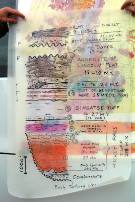
Just for all you volcanology fans, I've included a cartoon of the Tertiary volcanic section below.
Tertiary section


Some references:

Dilles, J. H., 1983, The petrology and geochemistry of the Yerington batholith and the Ann-Mason porphyry copper deposit, western Nevada, Stanford Ph.D dissertation.

Dilles, J.H., 1987, The petrology of the Yerington batholith, Nevada: Evidence for the evolution of porphyry copper ore fluids: Econ. Geol., v. 82, p. 1750-1789. Econ. Geol. online.

Dilles, J.H., and Einaudi, M.T., 1992, Wall-rock alteration and hydrothermal flow paths about the Ann-Mason porphyry copper deposit, Nevada--A 6- km vertical reconstruction: Econ. Geol., v. 87, p. 1963-2001.

Dilles, J. H., Proffett, J., and Einaudi, M. T., 2000, Field trip day two: Magmatic and hydrothermal features of the Yerington Batholith with emphasis on the porphyry Cu-(Mo) deposit in the Ann-Mason area, in Thompson, T. B., ed., Society of Economic Geologists Guidebook, 32, p. 67-89.

Dilles, J.H., Proffett, J. and Einaudi, M. T., 2005, Magmatic and Hydrothermal Features of The Yerington Batholith with Emphasis on the Porphyry Cu(-Mo) Deposit in the Ann-Mason Area, in Geological Society of Nevada, 2005 Symposium Field Trip, Guidebook 9 Porphyry Deposits of the Great Basin.

Dilles, J.H., Solomon, G.C., Taylor, H.P., Jr., and Einaudi, M.T., 1992, Oxygen and hydrogen isotopes characteristics of hydrothermal alteration at the Ann-Mason porphyry copper deposit, Yerington, Nevada: Econ. Geol., v. 87, p. 44-63.

Dilles, J.H., and Wright, J.E., 1988, The chronology of early Mesozoic arc magmatism in the Yerington district, Nevada, and its regional implications: Geol. Soc. America Bull., v. 100, p. 644-652.

Proffett, J.M., 1977, Cenozoic geology of the Yerington district, Nevada, and implications for the nature and origin of basin and range faulting: Geol. Soc. America Bull., v. 88, p. 247-266.

Proffett, J.M., and Dilles, J.H., 1984, Geologic map of the Yerington district, Nevada: Nevada Bur. Mines Geology, Map 77.

Proffett, J.M., and Dilles, J.H., 1991, Middle Jurassic volcanic rocks of the Artesia Lake and Fulstone Spring sequences, Buckskin Range: Geol. Soc. Nevada, Field trip 16 guidebook compendium, v. 2, p. 1031-1036.

Proffett, John M., and Dilles, John H., in press 2006, Lower Mesozoic sedimentary and volcanic rocks of the Yerington region, Nevada, and their regional context: Geol. Soc Amer Spec Paper, editors, John Shervais and Jim Wright.

Proffett, J.M., Jr., and Proffett, B.H., 1976, Stratigraphy of the Tertiary ash-flow tuffs in the Yerington district, Nevada: Nevada Bureau of Mines and Geology Report 27, 28 p.


Monday, April 14, 2008

Recent Travel Continued

I recently traveled to Yerington, Nevada, in order to participate in a geological short course on mapping porphyry copper deposits and alteration types related to the deposits. The mining district in question is the huge area of the Yerington porphyry copper deposits, related skarn deposits, and related possible IOCG deposits (Iron-Oxide Copper Gold).

This short course was put on by a group called MDRU, and was led by geologists John Dilles and Richard Tosdal. The course was excellent.I traveled to the course by way of some back roads or side trips. I drove these side roads so I could take some photos for future use. I turned south from Highway 50 at Middlegate Junction (the location of Middlegate Station, a great place to get burgers and fries), then took Nevada Route 361 down to Gabbs.
361
The turnoff from Highway 50 to S.R. 361 at Middlegate Junction.
Gabbs is the site of a long-standing magnesite mine, now operated by Premier Chemicals, LLC, and formerly, for a long time, operated by an outfit called Basic.
magnesite
The magnesite mine at Gabbs.
I drove through Gabbs - north Gabbs and south Gabbs - and took a few photos: of the grocery store, the gas station, the old cafe, which appears to be closed, and a few the houses and signs.
Gabbs
Brucite Street.
I then drove southward to the Pole Line Road, a main dirt road from Gabbs to Tonopah, stopping first at what used to be an old bar and pool hall next to the old Keystone Mini Mart. It was long ago a favorite hangout of many geologists, especially those at Former Mining Company.
Pole Line
Pole Line Road sign.
Then onward I went, turning south onto Pole Line Road. I drove down it a ways, taking various pictures, before I turned around and continued on my journey to Yerington.
Pole Line south
Pole Line northThe Pole Line Road to Tonopah is the site of one of my early geology stories, one about looking for my thesis area, so I needed some photos. These photos, or ones like them, may appear later in stories that I call exploration stories, Highway 8A stories, or Mojave Exploration stories. The stories don't all occur in the Mojave Desert, in fact, many occur in Nevada and some occur in non-desert areas. It was the uniqueness of the Mojave Desert, however, that inspired me to start writing the stories.

Updated 12Feb2016 primarily for formatting.

Monday, January 7, 2008

Where in the West - January

This lake, viewed from the south, is an interior salty lake in the western Cordillera. The mountain and lake are good examples of the horsts and grabens of the Basin and Range. Low-angle normal faults or detachment-style faults are known to occur in this region. The lake is known primarily for it's fishing, and although I've never fished in this lake, I've stayed in the town near it's southern edge many times, looking for gold in the hills to the northeast, east, and southeast. I first drove through this area in 1976 on my way back from looking for a thesis area.

References:
  • John, D.A., Thomason, R.E., and McKee, E.H., 1989, Geology and K-Ar geochronology of the Paradise Peak mine and the relationship of pre-Basin and Range extension to early Miocene precious-metal mineralization in west-central Nevada: Economic Geology, v.84, p. 631-649.
  • Best, M.G., and Christiansen, E.H., 1991, Limited extension during peak Tertiary volcanism, Great Basin of Nevada and Utah: Journal of Geophysical Research, v. 96, p. 13,509–13,528.
  • Dilles, J.H., and Gans, P.B., 1995, The chronology of Cenozoic volcanism and deformation in the Yerington area, western Basin and Range and Walker Lane: Geological Society of America Bulletin, v. 107, p. 474–486.