Showing posts with label ocean. Show all posts

Friday, March 7, 2014

A Where in the West Revisited: Rose Spit, B.C.

Flying back from Alaska on yet another recent trip, I was able to spot Rose Spit, which featured as a Where in the West challenge back in October of 2010. The shape of the northeastern tip of Graham Island — an island in the Haida Gwaii, or Queen Charlotte Islands, off of the coast of British Columbia up near Prince Rupert — always fascinates me.
The northern portion of Graham Island, with Rose Spit on the left below the wing, and Maset Sound in the upper right.
Maset Sound is a narrow, river-like entrance into the larger, saltwater body of water known as Maslet Inlet, which is somewhat visible beneath the clouds hovering over the central part of the island.
The waves around the spit were reflecting in a bright, yellowish glare from the mid-day sun.
A closer view of the convoluted shape of Rose Spit and its associated small islands.
A view of the spit, with a few of the small islands off its tip.
Related Posts:
Where in the West: October 2010
Where in the West: Rose Spit, B.C., Canada

Thursday, September 1, 2011

Homer Spit: Birds and Boats and Coal and Things (AK2011 Day 8)

The Homer Spit, with Coal Point at the end of the spit and Coal Bay near the beginning. From MSRMaps
After leaving the little lunch spot, we passed this (faux) lighthouse indicating that we were progressing on to Homer Spit, where Alaska Route 1, the Sterling Highway, comes to an end.
View of the Kenai Mountains across Kachemak Bay.

It was still rainy as we entered the spit, and powerfully windy. Here and there, we could see signs of campers on the west beach, their tents and gear tied down and heavily weighted against the wind.
Homer Spit is a bustling tourist stop, with places to eat, places sign up for and go out on halibut charters, places to buy touristy things, along with motels, hotels, condos, and B&Bs, not to mention at least a couple scattered bars and saloons. Over the many years of visits to Homer Spit, I've stopped here or there a couple times, mostly for suitable Alaskan lunches of halibut or such, but I haven't usually spent much time on the oft crowded boardwalks.
What I like to do is go directly to the end of the road and park overlooking the beach that wraps around the tip of the spit. (Google Street View of wet, potholed parking area.)

My mom and I were the only ones venturesome enough this time to walk down to the wet and windy beach.
After a storm, or almost anytime the wind isn't blowing as hard as it was, the beach is a great place to find shells and other things. Here I've found lots of rocks, mostly graywacke, and not so many shells. There is one black lump of a rock just above my foot, which might be coal. I'll get to that after a bit.
The beach is a good place to watch the waves, and to look at boats and birds.
Birds...
...and boats...
...and lots of birds, mostly gulls.
Down near the piers, you can sometimes find starfish frolicking in the waves or hanging out on the piers themselves. I've never seen this, but have found tiny living ones washed up onshore.
After not finding any starfish, I notice the coal once again.
Coal washes up on Homer Spit from a variety of sources, including some nearby seams of sub-bituminous coal to lignite found in bluffs cut into Tertiary sediments along the north side of Kachemak Bay. In fact, the Homer area was known for its coal resources long before the town was named in 1896 for con man Homer Pennock, who unsuccessfully promoted gold mining in the area for about a year before hightailing it off to the Klondike. Homer residents still come to the beaches after storms to collect coal to burn.

I leave the coal on the beach, and my mom and I retreat hastily to a drier environment: the car. We head back up the spit.
Here's a famous saloon I've never managed to stop in!
And we say goodbye to Homer Spit, Coal Bay, and Kachemak Bay. I wonder if the low, dark bluffs on the left expose low-grade coal beds.

Monday, August 29, 2011

A Rainy Trip to Homer / No Augustine: AK2011 Day 8

The 8th day started out cloudy, and gradually turned rainy. Here we're heading down to Homer, having already passed Clam Gulch, and having just passed Ninilchik. As we drove by, I was thinking maybe we'd stop at Ninilchik or the beach on the way back, though we hadn't gotten an early start, and I didn't know how rainy the day would turn.
Not much farther on, we pulled over to look at the view across Cook Inlet (in the far distance in this wide angle shot) and to look at the lupines and cow parsnip, which were also blooming alongside fireweed.
It is at about this spot that one might hope for a view of Augustine looking south down and across Cook Inlet. Augustine is an island volcano that last erupted in 2006. Check out these much better images (ha!) at AVO. Augustine (sometimes called St. Augustine or Mount St. Augustine but shown as Augustine Volcano on topo maps) is officially a stratovolcano, one with a central dome and flow complex or cluster; it's part of the Aleutian volcanic arc, and it's the most active volcano in the Cook Inlet area (location map at AVO).
Ah, yes. We arrived at this famous sign, which doesn't mention Homer as a "quaint little drinking village with a small fishing problem," supposedly seen locally on bumper stickers.
Despite the fall-like weather (even for an Alaskan summer), we manage to get this view of the Kenai Mountains across Kachemak Bay. The glacier in the upper left is a small glacier coming out near the Doroshin Glacier (not visible farther left or in the clouds). It probably has a name, but not on topo maps available to me (MSRMaps location).
Before a late lunch, we stopped briefly at the Alaska Islands & Oceans Visitor Center, which has some interesting wildlife and ocean displays and a nice little gift shop, where I bought art notecards of two puffins and four ravens.
The Visitor Center parking lot overlooks a small mud flat just below Beluga Lake (MSRMaps location).
That's Grace Ridge, tucked behind Sadie Cove and in front of Tutka Bay, across the flats and across Kachemak Bay.
By the time we finally stopped for lunch, the rain had become a downpour. Sitting outside was out of the question, although at least one brave (or crazy?) soul was out in the weather.
I had to take a picture of this "Local Organic Wi-Fi" sign, which I noticed when we were leaving the organic lunch joint.

A Couple Augustine References:
Power, J.A., Coombs, M.L., and Freymueller, J.T., eds., 2010, The 2006 eruption of Augustine Volcano, Alaska: U.S. Geological Survey Professional Paper 1769, 667 p., 1 plate, scale 1:20,000, and data files.

AND (part of above) Section 2: The Geology of the 2006 Eruption.

Related Posts:
Wordless Wednesday: I Love the Color of the Water

Record Reds

Down to the Kenai: AK2011 Day 4

At the Cabin: AK2011 Day 4

Fishing for Reds and Other Miscellany (including a Volcano): AK2011 Days 5-7

Wordless Wednesday: Seen at Homer

Friday, October 8, 2010

Where in the West: Rose Spit, B.C., Canada

Rose Spit, with North Beach to the right and East Beach to the left.

The October Where in the West location was won by Ron Schott (no Schott rule was invoked) for finding Rose Spit, which forms the northeasternmost tip of Graham Island in the Queen Charlotte Islands of British Columbia, Canada, about 35 km NE of Massett. The area can be viewed anytime the weather is clear and anytime one happens to get on the wrong side of the plane from Anchorage to Seattle (the right or west side), which MOH and I did about a year and a half ago, while returning from the start of the Iditarod.
The linear, north-trending East Beach in the foreground, with North Beach's beach ridges beyond and to the west.

Howard won the geology portion of WITW by noting the beach, spit, beach ridges, salt marshes or brackish lagoons between the beach ridges. I can't swear to the nature of the water between the beach ridges, but brackish to salty seems likely. Howard raised the question of whether the beach ridges are actually cheniers, which are beach ridges deposited on tidal mud flats or "on an alluvial plain of silt, clay, or peat on prograding deltas or coastal plains." I haven't found any information about what the sand ridges at Rose Spit are deposited on, so will have to go with beach ridge for now.
Also seen at Rose Spit:
"dissipative beaches backed by prograding foredunes on North Beach; reflective cuspate cobble beaches with a sandy low tide terrace on NW Rose Spit; and multiple-barred beaches backed by migrating foredunes and parabolic dunes on East Beach."
Pictures of these features — and much, much more — can be seen here, on page 3 and 4 of the pdf.

And from Overview of Geologic Hazards to Offshore Petroleum Development – British Columbia Continental Shelf:
"Megaripples, sand waves and sand ridges are particularly important in the vicinity of Rose Spit and Rose Bar at the northeast corner of Dogfish Bank. These features are the result of storm-driven sand motion on the shelf under the influence of topographic steering of tidal and wind-driven currents. In this area amplitudes of the sand waves and sand ridges can exceed 6 m. "
"The eastern coastline of Graham Island is largely dominated by a thick sequence of unconsolidated glacial outwash deposits capped locally by Holocene dunes. These sediments are retreating rapidly, with the eroded sediments being swept northwards towards Rose Spit. While average erosion rates apear to be about 1 m per year, retreat is highly episodic; in 1992-1993, for example, 11 m of land was lost at Cape Fife and 1.5 m was lost in a 24-hour period at the same site in 1994. Numerous, ephemeral shore-attached bars are associated with the high rates of longshore drift along eastern Graham Island. "
View Rose Spit at Flash Earth.

Some References:
Bornhold, B., and Harper, J., 2002, Overview of Geologic Hazards to Offshore Petroleum Development - British Columbia Continental Shelf, in BC Offshore Hydrocarbon Development, Report of the Scientific Review Panel (January 2002), Appendix 11.

Otvos, E., 2005, Cheniers, in M. Schwartz (Ed.), Encyclopedia of Coastal Science: Springer, p. 233-235.

Walker, I.J., and Barrie, J.V., 2006, Geomorphology and sea-level rise on one of Canada’s most ‘sensitive’ coasts: Northeast Graham Island, British Columbia: Journal of Coastal Research, SI 39.

Wednesday, October 8, 2008

Finally Some Fish: AK2008 Day 3

other boat As I noted in an earlier post about this Alaskan saga, it was hard to get photos showing the height of the rollers, as they called the waves out there in Cook Inlet. The photo above, of a relatively nearby fishing boat, is what we probably looked like as we rolled up and down, and as we got about the business of fishing.

BTW, I don't know if halibut fishing qualifies as an actual Alaskan Experience, in capital letters. I'd have to ask an Alaskan about that. I know that any bear encounter in Alaska qualifies. Fortunately, I haven't had any of those, except when inside a vehicle (and while Outside Alaska on the Alcan). And those were black bears, anyway, not giant grizzlies (a nice black bear picture here at Geotripper). In Alaska, I've only had encounters with grizzly tracks and grizzly scat.
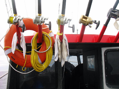
poles Back to fishing. First, you get down these huge fishing poles - or, rather, the deckhand working up there for the summer gets down the huge fishing poles - and then you jam them into some pole-holder-thingies on the sides of the boat. You don't hold the poles. The poles and fish are too large for that, and if you got a fish on while holding a pole, you'd soon lose both pole and fish. (At least that's how we did it - I can't tell for sure about the guys in the blue boat above.)
fishing stuff Before putting the poles in place, the deckhand has gotten them all rigged up with the appropriate gear. He puts a smallish fish on each line for bait, then you reel it down until the bait is sitting on the bottom, however far down that happens to be. I, personally, couldn't tell when the bait reached the bottom.

After awhile, in fact immediately, you will get a halibut on the line. The captain or deckhand says, "You've got one on!" Then you are supposed to let it eat and swallow the bait completely, without letting it take too long. You are not supposed to reel too soon to set the hook, as in regular river-type fishing; the halibut is supposed to set the hook itself. If you reel in too soon, you won't have a fish. If it nibbles awhile and you reel in too late, you won't have a fish. I totally could not get the hang of this! So by the time they would say to reel in, it would be too late. Or, thinking that I had it figured out, finally, I'd go ahead and reel in, then the captain (especially, the deckhand was more patient or pragmatical) would act all exasperated and go help someone else. Eventually, though, with the help of the deckhand, I finally pulled in two halibut. But give me silver salmon, any day!

We all caught our limit of two. That was eight 20-30 pound halibut for our group of four (MOH, my parents, and myself). We spent from about 10:30 am AKDT to about 12:10 pm AKDT catching our fish. So, that's get there: 1.5 hours; fishing: 1.5 hours; and then, head back.
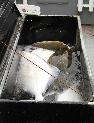
fish in box As you are catching the fish, the deckhand is putting them in a large metal box in the center of the back deck.
water on fish When fishing is all wrapped up and when things are all put away, the deckhand spends some time throwing water around to clean things up, including putting a bunch of water all over the halibut, to keep them cold.
Here, above, we have turned around in order to pull up the anchor, so we can hightail it back to shore.
Ah, shore. Does it look familiar? Well, it looked quite familiar to us, lighthouse and everything. With all the rollers pushing us from behind, it took us a lot less time to get back, from about 12:10 pm AKDT to 1:00 pm AKDT: about 1.5 hours going out v. less than 1 hour coming back in.
Seagulls, boats, and boatmen await our arrival on the beach at Deep Creek.
Land! I'm standing on it! No more rolling around!
As we come in, another one goes out.
Here are a couple views of the fish we caught. Big halibut strung up on this post would touch the ground. We caught a bunch of "chickens" - small, but good-eating halibut.
A second look at the white side of our halibut with captain for scale.
Our three largest fish, maybe 30-pounders or so.
And then we're done! So we drive north on the Seward Highway toward Kenai, stopping at the first coffee place, called Electric Beach Tanning & Espresso.
Then, after a long afternoon of cutting and processing fish, we have some beer in the evening, one of my favorites: Alaskan IPA.

Wednesday, October 1, 2008

On the Boat: AK2008 Day 3

1 There we were, finally on the boat. I thought the boat was rather small, expecting something larger with side decks you could walk around on, maybe something like this. Instead, there was the inside and the outside - cabin and back deck.
2 So, what do you do on the boat once you get there? Well, for one thing, you hightail it away from shore, generally keeping the sea-cliff at Deep Creek in your sights behind you for a very long time, as it gets smaller and smaller, and harder and harder to see.
3 You can sit inside the cabin, pondering this sign posted on the oh-so-tiny bathroom (which has just enough room to stand in while the boat goes back and forth, up and down).4 And while inside, you can watch the spray from the rolling waves splash against the cabin windows.
5 And you can peak out the cabin door, standing up while watching the waves, the wake, and the spray.
6 If you are quite brave, you can actually stand on the deck, but not too far back, never away from the cabin door, and always holding onto something. I found that location to be disconcerting and mostly just wedged myself inside the door, while MOH ventured out onto the deck. The parental types, more familiar with this boat-ocean thing, sat inside the cabin the whole time.
7We were in the water at 9:10 AKDT, and about a half hour later, we could no longer see the details of the coastline behind us, as we still hightailed it farther and farther out.
8 Birds, mostly gulls, came to follow the wake in anticipation of all the fish we were going to catch.
9 I'd tell you the names of the mountains, but I never figured out exactly where we were. Some of the mountains in these photos, the ones to the west of us, might be the Kenai Mountains down near Homer. I don't think we got as far south as Kodiak Island (in less than 1.5 hours!), and we never saw Augustine Volcano, which was probably to the south or southwest.
10 Flotsam and jetsam, which the gulls were immensely interested in, appeared now and then, and the lighting beneath the clouds and on the water was beautiful. The sea was rolling with large waves. My parents weren't impressed, but the captain said it was pretty bad. Maybe he said that to try to make us feel better. I tried to get pictures showing the height of the waves, but you can't really see it, nothing out there for scale, I guess. Perhaps if I hadn't rotated most of these photos so the horizon was horizontal; when I took them, I couldn't hold the camera steady relative to the horizon, only relative to the boat, so the horizon was moderately to highly tilted in most original photos.
11 Finally, at about 10:20 AKDT, more than one hour out, we started making the turn to set the anchor, so we could begin our fishing.
12