Showing posts with label carnivals. Show all posts

Saturday, July 20, 2013

AW #58: Beware of the Signs!

Evelyn Mervine at Georneys is holding another Accretionary Wedge carnival (two in a row!), this time it's AW #58: Signs! I was first thinking of some geographic signs along the lines of her original signposts meme, and realized the ones I was thinking of consist of license plates rather than mileage signposts, and that all the ones I have are probably non-digital and currently a bit hard to reach (nevertheless will try to post some when I'm not quite so busy). Instead, I dug up a sign from a trip to Crater Lake a few years back.
Hard to say whether this sign on a very steep part of the west rim of Crater Lake is to warn one away from the danger of the steep slope, or a warning that the mountain (cinder cone or entire caldera?) might blow!
Glacial grooves and striations, field sandal for scale.
Either way, if one persists past the sign in true geological fashion, one will find a great exposure of glacially striated and grooved volcanic rock. Read a little more about the glacial history of Crater Lake here.

Friday, June 21, 2013

Seeing Geology in Patterns

"This month’s Accretionary Wedge topic is “Seeing Geology Everywhere.” Like many geologists, I often see geology in places where there are no rocks. ...

"Do you see geology in unexpected places? Do you often find yourself viewing the world through geology-tinted glasses? Do you have any adorable cat pictures that could be used to illustrate geology?"

     – Evelyn Mervine, Accretionary Wedge #57 call for posts.
Stucco plaster wall texture by Sherrie Thai, some rights reserved.
It began a long time ago: maybe I was about 8 or 10 years old, and I'd stare at the wall next to my bed when trying to sleep. I'd see land masses or continents in the wall texturing, something that perhaps came from my early love of maps and globes, which naturally showed countries and continents. In fact, my brother and I had played a game in the back yard on lazy summer days: while looking up at the afternoon cumulus clouds passing by, we'd name them as though they were foreign or alien land masses of the sky. And then we would play a form of the floor-is-lava game, wherein we'd have to jump from the shadows of the cloud continents in order to not fall out of the sky (because we'd be imagining ourselves on the clouds, not on the ground).

What happens now most commonly, is that I'll be working on some geological problem or project, and I'll start seeing textures or patterns related to certain rocks or maps in floor tiles, walls, trees, clouds, or anything else that happens to resemble some geologic texture or map pattern.
Recently, having spent a lot of time looking at certain hydrothermally altered rocks, I noticed this floor texture that appeared nearly identical to a patchy quartz-sericite alteration style with irregular to wavy chloritic seams.
Enlargement of floor pattern.
Then, while taking photos of clouds the other morning, I noticed this pattern that reminded me of a vein with horsetail structure.
Cloud picture with added lines.
And finally, I often notice a color in the clouds that reminds me of the anomalous Berlin blue birefringence color typical of certain chlorite minerals.

Saturday, April 13, 2013

Accretionary Wedge #56: Landscapes as seen by a Geologist

Accretionary Wedge #56 is all about geologists and photographs, as explained by Andrew Alden, our host:
Once upon a time, you took a picture of something that lots of people photograph. However, because you are a geologist, it didn’t turn out the way it does for most people. Show us that picture, tell us what you see in it, and tell us about the way you take pictures.
I take a lot of photos. I can't begin to tell you how many rolls of film I used to carry with me for simple 3-day field trips back in the day of Kodachrome, but I can easily shoot a hundred or more digital frames in a day, the number being limited only by the number of gigs on my SD card and the percent charge on the two proprietary rechargeable batteries I carry with me: one in the camera, one in my pocket (except for yesterday, when I forgot the extra).

So, I take a lot of photos. I think about how I'm framing them when I'm shooting, about what will look good as a photograph. I think about what I'm seeing, about what the photographs might show myself and others. Mostly I just shoot, as many photos as possible.

I see a lot of landscapes and roadcuts when driving here and there (which is something I do a lot of). Sometimes the landscapes are like nice, wide, almost blank spaces to me, allowing my mind to roam or think non-stressful thoughts not generally related to life or work; other times I really contemplate the landscape and notice the shape of the hills, pediments, basins, and mountains, and I perceive or try to imagine or understand the way the landforms formed and evolved, how the rock formations are guiding the shapes in the land. I see contacts and faults, real and hypothetical, wherever I go.

Consequently, when I take a photograph — almost anywhere unless it is indoors or of people (and sometimes even then) — I am seeing something that isn't necessarily visible to non-geologists, and I see that something in the photo, even when it isn't obvious. The photographs I shoot often already have contacts and fault lines drawn and visible in my mind, and the erosional or depositional remnants of geologic time are jumping out of the scenery and into the frame. The landscapes and rocks are telling me their stories, even from a distance — sometimes they nearly shout their stories, sometimes they almost whisper. Either way, their stories are embedded into my photographs.
A fairly bland landscape photo looking across Rye Patch Reservoir.
In this photo, taken partly for the nice clouds and the inscrutable but interesting shapes of the hills in the lowlands across the reservoir, Majuba Mountain (AKA Majuba Hill) clearly stands out as a resistant, rather roundish knob.


I took no less than 12 photos of this hill as we drove by on our way to catch a plane. The place fascinates me, partly because I've never been there, and in large part because I know it's supposed to be a great mineral collecting site, with ores of copper, tin, uranium, gold, and silver and various minerals including torbernite, cassiterite, and tourmaline (read more here). There is also supposed to be at least five varieties of breccia. The knob is resistant and in the shape it's in because its a complex rhyolitic or granitic plug, and because of the attendant alteration that includes silicification. I see all that when I drive by, and all that shows up in my photo, at least when I look at it. But really, I've never been there, though I've had it on my list of places to visit for a very long time.

My last post shows an example of the contacts I see when I take a photo, and how the contacts can be drawn in at a later time for others to see.

Also, while walking or driving around, I notice landscapes and outcrops, roadcuts and exposures that tell stories of days gone by, days populated with geologists, pickup trucks, drill rigs, beer, dozers and backhoes, ice chests, map cases, and packs full of this and that, including hand samples, white bags filled with rocks or soils for assay, a water bottle or two, a small lunch, waterproof matches in a ziplock bag, an extra jacket or flannel shirt, a small 1st aid kit, and nowadays a SPOT. These things or places and their stories are harder to photograph, but I nevertheless see them almost everywhere I go.

Examples could be endless.

Thursday, October 4, 2012

Accretionary Wedge #50: The Fire at Field Camp

I had been thinking about doing a repost for this wedge—Accretionary Wedge #50: Field Camp/Trip Moments, being hosted by Evelyn Mervine over at Georneys—but realizing that the wedge is supposed to be about *one* fun moment, song, etc, put me into a tiny bit of a quandary  For me, field camp was a long, long time ago. By and large, many of the specifics of my memories of field camp have faded, and some (many?) of the specifics really shouldn't be reported online because they involve other people (plus or minus myself) doing things that shouldn't be reported without the permission of those involved, or shouldn't, perhaps, be reported at all. Not that we were the rowdiest bunch of field camp attendees of all time, or anything; I'm sure we weren't. As for fun field *trip* moments...well, there have been many, and a lot of those fall into the same category of things NSFO (not safe for online). I'll leave you to your imaginations. Or maybe I should just post sometime about shooting and rock throwing contests I've won out in the field...

Back to field camp. One fun or memorable moment or time [there, I've done it: used "fun" as an adjective three times now!] was at our last mapping project in the Swisshelm Mountains of Arizona, helping to fight a range or brush fire that had broken out across part of the map area. It was an exciting thing for a new field geologist to experience; at the same time, there was a certain tension involved: would we succeed? would our map area be ruined? (there were good and bad points to this latter possibility); would we get burned or injured in anyway? For the latter consideration, I think we were mostly in the invincible category at the time and probably didn't think very much about the danger to ourselves or about our overall safety, which was not treated as a huge deal back then the way it is now.

I was mostly involved in shoveling dirt onto hot spots around the edges, and in helping to move water containers to the lines. It was hot and smokey, the visibility was low, and my memory is tinged with orange. Memorable aspects of the day: we joined together in a common cause, we were fed dinner by ranchers also involved in the fire fighting, and the fire was stopped. I'm not sure whether we really cared that much about the range fire, at least not as much as the local ranchers or other fire fighters did, and we made jokes about hoping that the fire would at least burn down the cholla forest located on one of the east-west spurs of the north-south mountain—hoping at long last to be able to map that part of the spur, or to at least be able to walk through the area without massive attacks from stray cholla balls.

No such luck, though. The fire burned through the forest, blackening the cholla and dropping cholla balls all over the area, if anything making the forest more impassable than before.

Afterward, our mapping continued, under what turned out to be more difficult, not less difficult, circumstances: The limestone units and contacts in the upper hills had been reddened and obscured by fire retardant dropped from bombers.

P.S. There is some confusion between jumping cholla and teddy bear cholla, with the former being more likely to grab onto you and being restricted to the deep southwest (California and Arizona deserts), and the latter being somewhat likely to grab onto you and being found as far north as the Gilbert mining district northwest of Tonopah, NV.

This may be a jumping cholla rather than a teddy bear cholla, judging from the pictures shown at the previous USDA links. Keep this video in mind if you ever hear of anyone "flaming" chollas. It might be a case of revenge.

UPDATE 5Oct12: Possibly we stayed here, at Faraway Ranch. The location looks good, the view of the area on Google Maps looks okay, although I can't tell if the buildings are right, and the pond might be gone.

Saturday, June 30, 2012

Field Book Scribbles

Like Short Geologist, I'm unable to post much in the way of what I really write down in my field book, which usually consists of what I do every day (what I worked on or accomplished), who I talk to, phone numbers, ideas, things to do that I shouldn't forget, and other real miscellany. I prefer the kinds of Rite in the Rain® field books that have a grid on one side, title blocks on each page, page numbers, and lots of goodies in the back: these. Because I can't really get into who I've been working for in particular, or when, I've shown a typical title block as mocked up a little: location, date and weather (when a page has notes from more than one day, the rest of the dates and weather go farther down the page), client, and random comments or notes as desired. I don't usually use the scale portion; instead, I draw a scale with diagrams or sketch maps as needed.
On rare occassions, I fill out the table of contents at the beginning of the book. Here's my only "current" example.
I found a few pages here and there that I can photograph to show my general note scribbly-ness. I'm not nearly as neat and exacting as in my early field book years, when I filled them out like I was still in field camp and might get graded at any moment, using neat, small lettering, and very nice drawings. This one is from a field trip up in Alaska. I was obviously concerned about which way some fault or other moved, and am still not sure whether I got it right.
A little drawing of the North Window at Arches National Park, which goes with a photo I haven't digitized, and this watercolor.
Here's a few scribbles from a March, 1998, field trip to the Fort Knox gold mine near Fairbanks, Alaska: "low grade .013-.019 [ounces per ton]." I imagine the "low grade" is lower than that now.
Here's a little (and partial, I'm sure) story about the discovery of the Gold Bar gold mine from a May, 1998, field trip to several gold mines in central Nevada. "Lots of 'smoke' on range front." The underlined "picture rock" indicates that I took a photo and have a rock sample lying around somewhere, probably in a box in the garage.
In the back of my field books, you'll typically find some version of a calendar.
And scattered here and there, you might find doodles taken during some meeting. This one shows a horn of plenty (i.e., ore), on a table??, next to an evergreen tree.
My meeting notes (yes, I generally take meeting notes in my field book so I can find them later), often contain fairly elaborate doodles. Here's a mine adit on a hillside, or maybe it's a hobbit's home.
My field mapping notes, which are small and blurry in this photo by design, are often messier than this, and usually quite succinct.

Oh, and my field books are mine. They don't belong to the company I consult for, unless the company buys field books for me and requires ownership by contract, something I would strongly resist. Companies have a habit of losing things and getting rid of things after projects are over. I don't think I've had to give up any of my field books so far. I *have* left copies of field notes in company files when requested. It's good to know ahead of time that someone will want a copy; that way, I won't accidentally put extraneous notes from one company's business in the middle of pages that will go into a second company's file.

More of my field books can be seen here, at least from the outside.

Submitted to Accretionary Wedge #47: Field Notes.

Thursday, May 3, 2012

Wedge #45: Geological Pilgrimage

Having been provoked by a recent online coversation, I've decided to take a quick moment to post a (late) addition to this month's Accretionary Wedge topic, a geological pilgrimage to "a single place, which is 'geologically' unique, relatively remote, and requires some difficulty to get to.'" I had thought I wouldn't post anything, because I'm not sure of making it anywhere besides, possibly, Midas, Tuscarora, and the Galápagos Islands, all of which I've put off for years, but which are all still on my list. But, taking a page from Ron Schott, I'll post briefly about a place I'd really like to see, though I have no particular plans or prospects of getting there: the South China Karst, also here and here. I don't really know why I find the area fascinating, but here is one video showing some of the lure, with some alluring music:

Friday, February 24, 2012

De Re Metallica

A—Twig. B—Trench.

Prospecting by twig and trench, as shown in one of my favorite books, De Re Metallica by Agricola. Source of image: Wikimedia.

Therefore a miner, since we think he ought to be a good and serious man, should not make use of an enchanted twig, because if he is prudent and skilled in the natural signs, he understands that a forked stick is of no use to him, for as I have said before, there are the natural indications of the veins which he can see for himself without the help of twigs. So if Nature or chance should indicate a locality suitable for mining, the miner should dig his trenches there; if no vein appears he must dig numerous trenches until he discovers an outcrop of a vein.

For a miner must have the greatest skill in his work, that he may know first of all what mountain or hill, what valley or plain, can be prospected most profitably, or what he should leave alone; moreover, he must understand the veins, stringers[1] and seams in the rocks[2]. Then he must be thoroughly familiar with the many and varied species of earths, juices, gems, stones, marbles, rocks, metals, and compounds. He must also have a complete knowledge of the method of making all underground works. Lastly, there are the various systems of assaying substances and of preparing them for smelting; and here again there are many altogether diverse methods.
[1] Fibrae—"fibres." See Note 6, p. 70.

[2] Commissurae saxorum—"rock joints," "seams," or "cracks." Agricola and all of the old authors laid a wholly unwarranted geologic value on these phenomena. See description and footnotes, Book III., pages 43 and 72.
Quotes are from De Re Metallica at Project Gutenburg,
Book II and Book I, respectively.

Read De Re Metallica at Project Gutenburg.
Read De Re Metallica at Internet Archive.

This post has been submitted to Accretionary Wedge #43 at In the Company of Plants and Rocks.

UPDATE: Geologic Illustrations Galore -- Accretionary Wedge #43 is now up!

Saturday, December 31, 2011

Accretionary Wedge #41: One Small Event from Hawai‘i's East Rift Zone

This month's Accretionary Wedge, being hosted by Ron Schott at his Geology Home Companion Blog, is all about the Most Memorable/ Significant Geologic Event That You’ve Directly Experienced. For myself, it often seems as though I'm on the spot shortly after significant events, rather than during them, which isn't entirely a bad thing. One ongoing event that I did witness in part is the eruption of Pu‘u ‘Ō‘ō. Pu‘u ‘Ō‘ō is the active vent in the East Rift Zone of Hawai‘i's Kilauea volcano.

Pu‘u ‘Ō‘ō in May, 1987.

In late May, 1987, I attended the Cordilleran Section meeting of the GSA, which was in Hilo on the Big Island of Hawai‘i during one of Pu‘u ‘Ō‘ō's many eruptions (Episode 48, which lasted from 1986 through 1992 and consisted mostly of lava flows from a new vent, Kūpaianaha, although I don't remember hearing that name in 1987).
A young geologist with bright red Lang Drilling hat and Nikon camera sits on a 1972 pahoehoe flow that cascaded over the Holei Pali (pali = cliff).

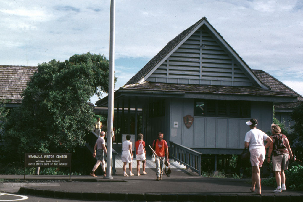
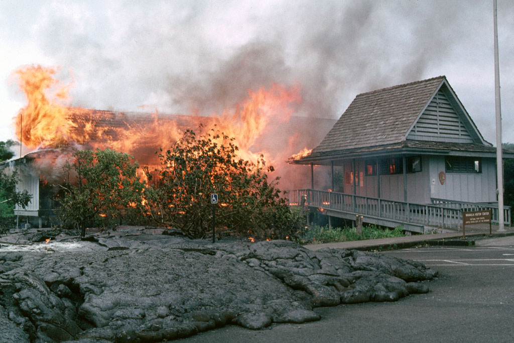
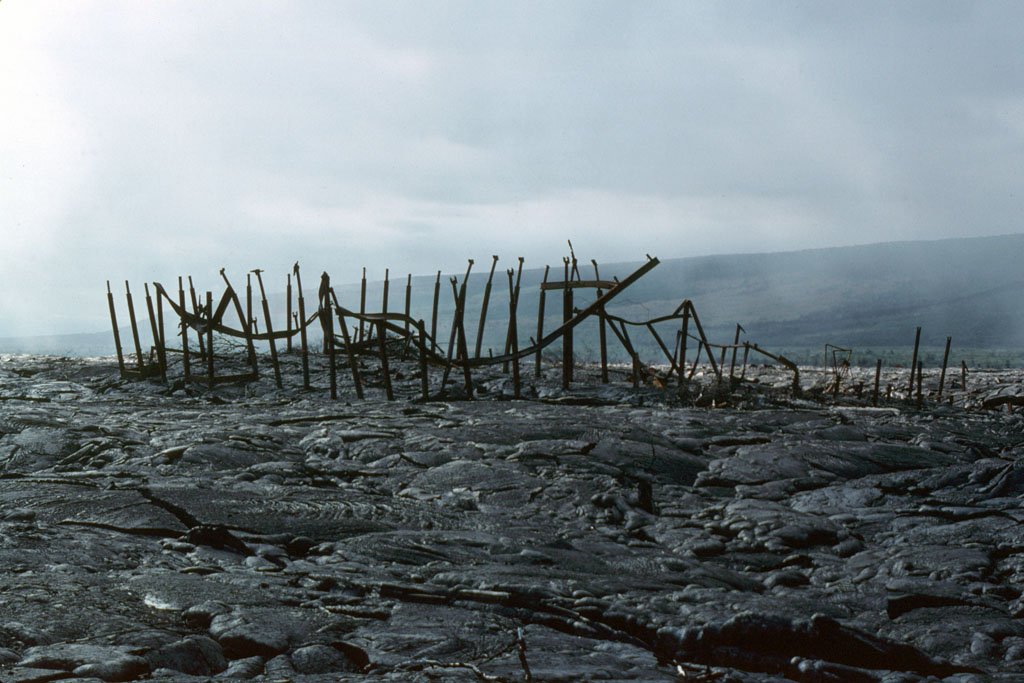
The timing of the GSA meeting in Hilo wasn't bad, although maybe it wasn't perfect, and the volcano-oriented field trip I went on before or after the meeting took us down the Chain of Craters road to the Waha‘ula Visitor Center (USGS TNM 2.0 Viewer location of the Visitor Center near Kupapau Point, showing an old topo map). The Visitor Center was later destroyed by a 1989 flow (before, during, and after photos).

We arrived on the scene in time to see a scene similar to this one from a slightly earlier field trip: the Chain of Craters road blocked just east of the then extant Visitor Center by what was for us a week-old lava flow.
This is the week-old pahoehoe flow, which flowed southeastward from its vent at Kūpaianaha, ultimately making it into the ocean. The lava was still hot, although not molten at the surface. We had been cautioned to bring boots with Vibram® soles. A couple orange hot spots can be seen in the original print of this photo (notably in the dark shadow between the two geologists on the flow, click to enlarge). We were the only ones allowed out on the flow that day, and our trip leaders guided us carefully around (and away from) thinner and more dangerous spots, places that were thought to be more likely to collapse.

Flow activity in the area had begun about six months prior to our visit; even the 6-month-old part of the flow radiated heat and was warm to the touch.
Here, a geologist stands next to one of the open cracks while a stick stuck just below the surface bursts into flames.
My best closeup of hot lava only three feet below the flow surface we were walking on.
In the distance, steam is rising from the week-old lava flow where ocean waves are hitting the flow.

Black sand beaches had already started forming along part of the six-month-old flow. The land surface had been extended oceanward by the flows; we were told that all new land belongs to the state of Hawai‘i. Several of these flows, along with earlier flows of 1983 through 1985 (eruption Episodes 1 through 47, I think), destroyed houses in the area and blocked the road toward Kalapana. Housing and subdivision destruction continued with later parts of Episode 48 (1986-1992) and with even later eruptions. While we were there, some people were still hopeful that roads would be rebuilt. Roads can be built on new flows after about 1 to 1.5 years.
The flows we saw that year are shown here in black, lumped with all the Episode 48 flows erupted from the Kūpaianaha vent (map from Heliker et al, 1998, detailed version here). In 1987, the flows weren't as extensive as shown here, especially on the west side where the Waha‘ula Visitor Center was still intact.

We were quite excited about walking on the flow, and sometime after the field trip a few other geologists and I went around to the eastern side of the flow where a tongue of lava was coming down the hill from above. A couple people ran up to the flowing lava to take a close look. I think we were about a hundred yards below the molten rock, and I kept wondering if unknown lava tubes would unexpectedly spurt lava out closer to us, but nothing quite that exciting happened (thankfully, in my view).

Additional Information:
Summary of Pu‘u ‘Ō‘ō–Kupaianaha Eruption, 1983 to present at HVO.

Heliker, C.C., Mangan, M.T., Mattox, T.N., and Kauahikaua, J.P., 1998, The Pu‘u ‘Ō‘ō - Kūpaianaha Eruption of Kīlauea, November 1991–February 1994: Field Data and Flow Maps: U.S. Geological Survey Open-File Report 98-103 Version 1.1.

Heliker, Christina, Swanson, D.A., and Takahashi, T.J., 2003, editors, The Pu‘u ‘Ō‘ō-Kūpaianaha Eruption of Kīlauea Volcano, Hawai‘i: The First 20 Years: U.S. Geological Survey Professional Paper 1676.

Takahashi, T.J., Abston, C.C., and Heliker, Christina, 1995, Images of Kilauea East Rift Zone Eruption, 1983-1993: U.S. Geological Survey Digital Data Series DDS-24.

A Couple More Maps:

Map of flows from Pu‘u ‘Ō‘ō: April 30, 2008.
HVO source here.

Kīlauea East Rift Zone Eruption Map: December 27, 2011.
HVO source here.

UPDATE: List of AW#41 participants.

Updated 2Jun2016, minor link revision.

Thursday, September 29, 2011

Accretionary Wedge #38: Back to School and Beyond

This month's Accretionary Wedge theme, as described by Anne Jefferson at Highly Allochthonous, our host, is "Back to School." The theme is fairly broad, with topics or questions for geology students, geology professors and geoscience teachers in general, industry folks like myself, and all geoscience enthusiasts.

First of all, I'd like to encourage everyone who gets into geology to follow your own path, wherever it may take you. If you are the sort of person who likes to plan things out ahead, do so; if you like to follow your nose, do that and don't look back.

Some people have asked me what industry needs or wants. I can only attempt to speak for the mining and minerals exploration industry, and can't speak at all for the petroleum or environmental side of things. What we "need" in the mining industry isn't necessarily anything a student of geology can plan on. Things change. If you want to aim in our direction, do get into it for your love of geology, your love of minerals and ore deposits, and your love of discovery. Discovery is what we do. Or, get into it for the wonderful opportunities to study complex structure that you will find at every mine and prospect. Structural preparation is often integral to the formation of ore deposits.

These questions,
If you are outside academia… what needs do you see for the rising generation of geoscientists? What skills and concepts are essential? Are there skillsets that we aren’t doing a good job of imparting on students? How important are things like communication and quantitative skills versus specific knowledge about rocks/water/maps? If you could go to a group of undergraduate geosciences majors and give them advice, what would you tell them? What would you tell their professors?
made me think of a few things. So follow a few random thoughts.

  • First, I don't know where geology in general is heading, what kinds of geologists will be needed in the future, or in what numbers. For mineral exploration geology, I do think that in the forseeable future a background in mineralogy and petrology will still be needed, along with increased need for experience in certain types of computer programs (various GIS and modeling programs). Some of these programs can only be learned on the job or through short courses.

  • Field experience is valuable, and will hopefully remain so, otherwise we will end up with a generation of modelers who have never looked at what they are modeling, something a sane world should not want. Although I've seen hints of this type of thing happening here and there and every now and then, senior-type geologists have been, so far, stepping in to keep things on track.

  • The need for good communication skills can never be understated. Today, a lot of on-the-job communication is done by cell phone and email, but knowing how to write a good report, long or short, is quite valuable, a skill that is often overlooked by geologists, a skill that could often be improved upon. At the very least, you will have to be able to communicate to management — people who are not always geologists — why you need the money, why your recommendations for next year should be funded. This communication will often be both written and verbal, the latter being given to groups in slide presentations.

    When I taught Op Min and Petrography/Petrology (including all or most of the basics of the non-lab portions of those classes), my co-T.A. and I required "Rock Reports" about rocks and their accompanying thin sections, mostly to let students practise their writing, and to help them realize they would most likely have to write similar short, descriptive to interpretive reports or memos on the job. We graded down for misspellings of rock and mineral names, and we graded down for left out mandatory rock-report sections (I don't remember what format we used). Spelling is now easier, perhaps, because of Word and Google; good sentence construction is corrected only approximately and often incorrectly by Word.

    A thesis is a good place to get some practice writing in the standard scientific format. I recommend seeking out someone who will give good editorial feedback.

  • Another thing that comes to mind is all the black box type of data collection and data creation tools that are available now, including portable XRFs. These devices in particular remind me of the tricorders used on Star Trek. Point the thing at a rock, and it will tell you all you need to know.

    Well, maybe. It will tell you something. Will it tell you how much gold is in the rock? Probably not, or at least not unless you can already see the gold, or unless the gold is present in ore-grade amounts. (1 ppm Au is often ore grade; cutoff grades at heap leach mines can go as low as 0.003 to 0.005 ounces per ton, which is about 0.10 to 0.17 ppm gold, way below any XRF detection limit I've seen so far.)

    Anyway, the point I'm working towards is that a good geologist will not be out in the field just collecting numbers with any type of device or black box, although we certainly do that with portable XRF devices, PIMAs and TerraSpecs, and various types of geophysical surveys. A good geologist will need to know when the numbers don't make any sense and why. And you will need to know what those numbers mean and what you might do with them.

    For example, if you are going to believe a tricorder that tells you you've just discovered the next Mother Lode, but you don't know how to recognize common and less common associations — minerals such as fuchsite, types of structures including veins, faults, and suture zones, and general and more specific rock types such as greenstone and grey ore — you might be disappointed when chemical (real) assays come back. You will sometimes be disappointed looking for new ore deposits, anyway, but relying on any kind of black box with no way of evaluating the results it hands you is a sure guarantee of disappointment.

  • So, I say, learn the basics, which include rocks and minerals, and learn basic field mapping skills. Especially learn how to find out things you don't know. Ask questions, try to find answers. Learn to be an observer of all things, and learn to look for things that are unusual, things that might seem out of place but are there anyway, and things that might be there but are obscure or hidden by other more obvious features, textures, or structures. Becoming a keen, trained observer will hold you in good stead through your entire geological career, and in life, no matter where you might go.

    UPDATE: Accretionary Wedge #38 is now up at Highly Allochthonous!
  • Thursday, August 25, 2011

    Accretionary Wedge #37: Geology that makes you sweaty and warm.

    Lockwood has come up with a sexy topic for this month's Accretionary Wedge — yes, you guessed it (or already knew): Sexy Geology. For the record, Lockwood has defined "sexy" as:
    I mean geology that makes your heart race, your pupils dilate. Rocks and exposures that make you feel woozy and warm. Structures and concepts that make your skin alternately sweaty and covered with goosebumps. Places you've visited, read about, or seen photos of that make you feel weak-kneed, and induce a pit in your stomach.
    I'm in a bit of a rush these days it seems, and so I'm just going to post a couple photos of some geology that always turns me on, and two links to related posts from earlier this year.
    Beds and bedding are always of interest to geologists; cross-bedding is best.

    Related Posts:
    Cross-Bedded
    More Cross Bedding

    Also see Callan's recent post.
    Photos are of the Jurassic Navajo Sandstone in Zion National Park, on Utah route 9, the Zion–Mount Carmel Highway, a few miles east of the Canyon Overlook Trailhead.

    UPDATE: Accretionary Wedge #37, Sexy Geology, is now up at Outside the Interzone!

    Thursday, July 14, 2011

    Left Behind: Pink Point

    It's rare that I haven't brought too much back from the field, rather than too little, so I had to think hard about the question for this month's Accretionary Wedge:
    What do you regret leaving behind at a geological locality?
    and I'm not sure that what and where I left this one thing qualifies as terribly geological.

    One day, while in the middle of our 1978 helicopter camp in Hot Creek Canyon (camp #3, not yet blogged), I was let off by the helicopter in the early morning on the top of a drainage — a fairly typical thing for days when the helicopter was in camp. That particular morning, there was no good place near the top of the drainage to be let out, and so the pilot put one skid on a rock outcrop jutting 10 or 20 feet up in the air, a rocky mass all surrounded by dense juniper and piñon. He told me to hop out on the downhill side. (We hadn't really gotten any hover-exit training the way Indiana Meg did; our pilot seemingly expected us to know everything he learned over his many years in Vietnam and Alaska.)

    I looked, and sure enough it was somehow possible; after I threw my pack into the brush below me, I managed to get myself onto the skid. Maybe it was only 5 feet down, but it was the hairiest "landing" save one other that I can recall.

    The rest of the day was somewhat standard save for three things.

    (1) I found a large pink projectile point in the middle of the drainage I was walking down, a drainage that had obviously seen some flooding in the last 1 to 5 years. The point was possibly made of Ivanhoe "chert" (more precisely opalite or silicified tuff) from the Tosawihi Quarries of northern Nevada, a large series of rock quarries made by ancient to nearly present-day native Americans in the Ivanhoe mercury-gold district north of Battle Mountain. I had been trained by my archaeological contacts to leave things like this in place, but I debated a long time before complying and moving downstream. GPS didn't exist back then, so I carefully spotted the location on my 7.5' topo map, planning to report the location later to the NAS or BLM. The problem with this approach is that the point was an anomaly: it was probably washed downstream in the most recent flash flood and would probably end up being buried by the next. I should have picked it up, marked the location on the map, and turned it in to a museum or some other appropriate outfit.

    That's the thing I regret leaving in the field.

    (2) A second fairly unusual thing happened that day when I nearly stepped on a rattlesnake. It was by no means the first rattler I'd seen that summer, but it was the closest I had come to one without being warned. I was walking rather quickly downhill through some trees, having bypassed part of the drainage because of dense vegetation. I stepped, and in mid-step I saw the rattlesnake just as it saw me. I sidled rapidly to the right while it slithered rapidly to the left. It had absolutely no interest in making a stand, which is what I've found to be the case in most of my rattlesnake encounters. Needless to say my adrenalin shot up.

    (3) Later that day, after having walked and sampled the entire drainage down to the range front, I picked out a likely helicopter landing spot on the upper part of the alluvial fan. The sun was hot. The willows, or some other large, clumpy masses of sticks with minimal leaves, were not casting any shadows worth using, and trees were lacking. I took my flannel shirt (worn in early morning when the temperatures were sometimes chilly) out of my backpack, placed it half over a sagebrush and half over my head and face, and lay down under the shade I had just created.

    I think that the only reason I recall the last bit is because of the three earlier unusual events and because it was possibly the first time I created shade in the desert that way. The trunk of a juniper tree would have been most welcome.

    ---

    For the record, I also regret leaving behind one or two boxes of jasperoid from my thesis area in the yard or shed of a house I moved away from in 1979 or 1980. As far as I know, samples of that jasperoid no longer exist, certainly there are no more outcrops of it.

    Related Posts:
    A Few Rules of the Desert
    The Caliente Series & Caliente Camp Series

    Friday, June 24, 2011

    A Favorite Word: Detachment

    While working every day for the past 17 or 18 days, whatever, I've been thinking on and off about what my favorite geological word might be, while also writing up an internal report that includes a large number of definitions. I was having a hard time writing anything at all for the blog, being thoroughly overloaded by words and definitions, and couldn't focus well on more words, favorite or otherwise.

    Finally, though, I thought of one! (Well, actually I though of two others, but I won't digress... ha! Oh, and at least two other great words have already been used: mylonite and welded tuff.)

    The word: Detachment, more specifically Detachment Fault. The entire post envisioned a couple nights ago, "Detachment: See header photo." (That's the one up there, above this blog post.)

    I have gone a little beyond that short, terse post, but won't really get into a definition, which would involve a low-angle normal fault of regional extent, probably created by, or during a period of, what is sometimes known as "extreme extension."

    Official AGI definition for detachment fault.

    Detachment Fault: a good geological mystery book.

    A number of Detachment Quotes.

    My posts labeled "detachment" (there are only 20 so far, including this one).

    Detachment fault on Facebook (it has no friends!)
    The Northern Snake Range décollement or detachment fault as seen from Great Basin National Park.

    This post has been submitted to Accretionary Wedge #35: What's Your Favorite Geology Word?

    Thursday, May 26, 2011

    Some Thoughts on Weirdness, and A Picture (or Two) (or Three)

    I've been thinking about the idea of weird geology, ever since Dana at En Tequila Es Verdad introduced the topic for Accretionary Wedge #34 — I haven't been thinking about it long and hard, mind you, because I've been busy writing geo things at work, using up both my writing and thinking capabilitites. I wrote a little, thought a bit; then, after thinking some more, I thought I’d finish up this morning at the laundromat, but it tuns out they don’t have wi-fi, which is one thing I find not only entirely weird, but just a little bit irritating.

    I have a few thoughts about geological weirdness, the biggest of which is that after all these many years (however long it’s been), I am no longer as surprised by the things rocks can do as when I was first starting to map as part of my job back in the late 1970’s. Back then, I learned an important lesson that has stuck with me over the years, which is: if the rocks are doing something you don’t think is possible or which you have never heard of or read about, look again. Have another geologist come check out your contacts and the nature of whatever weirdness you think you spotted, and brainstorm some ideas. Chances are, you have run across something merely unusual but not impossible. You will have to go with whatever the rocks are telling you that they did on their way to becoming whatever thing they are now.

    Volcanic rocks, inside or outside the Huge Caldera settings sometimes known as "Supervolcanoes," can do some particularly unexpected things. When anywhere near them, learn to expect the unexpected and to throw out preconceived notions as soon as it becomes clear that you need to (which isn’t all the time, admittedly). Apply this way of thinking to other, non-volcanic settings. Over the years, expecting the unexpected will serve you well.

    Other places to expect particular geologic weirdness are 1) anywhere in the Basin and Range province and 2) any time you are anywhere near a metamorphic core complex or where you suspect that you are in detachment or extreme extension terrane. I’ve found tilted Precambrian rocks above a 50-foot thick, crumbly, weakly mineralized mesobreccia of gneissic rocks, all sitting on top of tilted Tertiary sediments that included soft, punky lake beds. Possibly this unusual tectonic stratigraphy of very-much-older over very-much-younger was not produced by extreme extension, possibly the Precambrian was thrust over the middle to late Tertiary via a thrusting method related to left-lateral strike-slip faulting along the Garlock Fault. Who knows? We never drilled deep enough to find out what lay beneath the tilted Tertiary rocks beneath the tilted Precambrian rocks.

    As for weird today, I'll just leave you with these pictures of a giant breccia (breccia in the foreground, breccia in the background). We were driving into the slot-canyon portion of Titus Canyon, a one-way dirt route into Death Valley from just south of Beatty. We drove around a curve in the road, suddenly coming face to face with a megabreccia. I slammed on the brakes (not that I was driving very fast to begin with).
    The same angular rock fragments from the first photo can be seen in this second photo, this time without anyone for scale. The breccia extends at least 35 to 40 feet up the wall.
    In reading up on this breccia, I found more than one explanation, including more than one kind of sedimentary origin to vaguely cited tectonic causes. Anyone have any ideas?

    For a picture with better scale, go here.

    Too bad I didn’t get a picture of myself standing in front of this magnificent megabreccia!

    Related Posts:
    Carnival of the Arid #4 is Up! - and Titus Canyon
    Things You Find in the Field: Leadfield

    UPDATE: Accretionary Wedge #34: Weird Geology is now up at En Tequila Es Verdad.

    UPDATE II:The Encore to the #34 Wedge is now up! (The first Wedge to come in two pieces.)

    Sunday, April 17, 2011

    Rocks and Stones

    For a long time, when I was young, I really wanted to someday have a stone house to live in, and I think that thought started somewhere between our home in northern Virginia and the National Zoo in downtown D.C. I vaguely recall that we drove by a particular stone house while going to the zoo, or to other places downtown, and it became my favorite, something I aspired to live in someday "when I grew up." As for pictures, because I didn't spot anything while driving around here locally, perhaps my stone house or cottage would look something like Moore's Station, or maybe it would look something like this hobbit home.

    Sell Art Online My original stone cottage was made of large, gray, roundish stones of unknown rock type, and it had large stone steps leading up to it. I can't say for sure whether ivy grew on the walls, but tall, thick trees partly hid it from view, making it appear mysterious and even more enticing. It was in the middle of a city where I would no longer want to live, and probably wasn't as colorful as this painting.

    After moving back to the west, I gradually learned to stop wanting to live in such a building because I consider Nevada to be earthquake country, with stone and brick houses just sitting there waiting to fall down in some next future earthquake similar to whatever one created the nice fault scarp on the eastern range front of the Carson Range near Genoa.


    Old buildings like this one at Pritchard's Station, made of ash-flow tuff and sitting out in the middle of nowhere, are probably as close as I will come to having a stone cottage or cabin, though we would like to have slate or other stone siding on lower exterior walls when we build, maybe some slate walkways through garden areas, and it's always possible we'll have some slate as part of the floor near an entryway.

    In the meantime, I realized this morning that I prefer to have most of my rocks outside, and that our building plans are pretty vague. Also, my few indoor rocks are messily and non-photogenically lying scattered through the house, and my yard rocks are out in the mud, currently getting re-covered by the latest snow shower (a relatively miniscule thing compared to the snow dump of April 7th and 8th).
    I also realized that we have all the rocks we want on the hill above our house, along the roadside as we drive to work, and everywhere we go out in the field.

    Written April 13th and submitted to the April 2011 Accretionary Wedge at Geological Musings in the Taconic Mountains.

    Wednesday, January 26, 2011

    How to Make Coffee Strandlines or Rhythmites

    Once upon a time, MOH and I left suddenly for an unexpected trip of unknown time duration, and I failed to empty all the coffee cups. Upon arriving back, having been gone most of 14 days, I tentatively looked in my cup expecting to find terrible mold, instead finding these lines of coffee deposited around the side of the cup.

    "Varves!" I exclaimed, "Except they aren't from yearly deposits, they're from daily deposits!"

    I've reflected a little, and asked a few close-at-hand sources, and decided these aren't really varves — and they probably aren't really rhythmites, either — for the simple reason that varves and rhythmites would be layers, of concentrated coffee in this case, that would have been deposited in the bottom of the cup. Instead, these must be more akin to strandlines — or shorelines around a coffee lake, in this case — as suggested by @GeoTheoBO. Other suggestions for what to call these deposits were Stratified Caffineite (@CGKings317), rhythmites (@alexbirtwisle), and my favorite, "Jarves" from "Java-varves" (@Dhunterauthor). Everyone else is welcome to jump into this discussion and naming exercise in the comments.
    Prior to deciding that these were really the results of daily evaporation of coffee, I did count the rings. There are 13, with a possible incipient 14th one near the bottom representing the partial 14th day during which we arrived back in time to check the cup. The lines I've drawn above are based not just on the locally fuzzy record shown in that one photo, but on the three photos I took documenting the entire stratigraphic record around the entire inner part of the cup.
    Here are the final determinations. A few of the days are a little fuzzy and the lines have been brought in from the side, just like you might have to do when correlating deposits out in the field. Most day's deposits are light toward the bottom and darken upward, possibly reflecting something having to do with diurnal temperature and humidity variations. To be honest, I don't really know when the darkest portion of each day's ring forms, whether at night, during the day, or at some other time. The cup was sitting on the kitchen counter in the sunlight of the window the entire time we were gone; evaporation would presumably have been strongest during the daylight hours, possibly resulting in the lower, lighter colored part of the layer. Any other thoughts?

    This post has been submitted to the Bake-Sale Accretionary Wedge (AW#30), though no baking was involved.

    UPDATE: Accretionary Wedge #30: the Bake Sale is now up at Mountain Beltway. It's a very yummy Wedge, I might add.

    Tuesday, November 30, 2010

    I Can See For Miles...

    ...and miles...
    ...and miles...

    That's basically what I like best about the geology of the area I live in (Nevada in general, the Basin and Range even more broadly), and as I've probably mentioned before, I moved west primarily to get away from what I perceived as an overabundance of biology over geology (see Dana's AW#29 post for more on biology v. geology). I also moved west to return to the general area I grew up in. I've stayed here ever since, except for a brief sojourn in that northern state known as Alaska (Yes, it's a state. Some people Outside — here in the Lower 48 — don't actually know that.)

    And so begins my short but sweet post for Accretionary Wedge #29 (almost too late for an entry due to winter weather, winter un-wellness, and winter work), a Wedge which is being hosted this month by Ann at Ann's Musings on Geology & Other Things. The questions? "What Geological features about the area you call 'home' do you love? and what do you not like?"
    I love the mountains. (Note the trees and above-tree-line alpine terrain, a sometimes underated or underexplored feature of the Basin and Range.)
    I love the valleys. (Note the hot springs in the foreground, a nice and warm geologic feature of the Basin and Range.)
    I love viewing the mountains from the valleys. (Note the prominent range-front fault, one of the many fascinating geologic features of the Basin and Range).
    I love viewing the mountains and valleys from the tops of mountains whenever possible. (Note that you are looking at the south end of one of those huge Nevada-style, mid-Tertiary calderas to the left of Mount Jefferson, the third highest mountain in Nevada, and also that you are looking at the place where that green helicopter pilot left me out all night many years ago in mid-October. Brr.)
    If there's anything about the geology of Nevada and the Basin and Range that I don't like, it's that there is just too much of it for me to see it all!
    This post has been brought to you by the Basin and Range of Nevada, Idaho, Washington, Oregon, California, and Arizona (primarily Nevada in this particular case). Basin and Range also occurs in Mexico, and I've seen a patch of it up in the Yukon (with Artemisia!). [And I forgot Utah!] More on the Basin and Range here. More on the range-front fault shown above here.
    Basin and Range! Yeah!!