A River Runs through It [link to download], ESW 2016, E-59 NBMG: Truckee River Reno to Pyramid Lake
1915 Pleasant Valley earthquake centennial field trip guidebook: A public field trip to visit the largest earthquake in Nevada's history [link to download] E-58 NBMG: 50 miles south of Winnemucca
Fire and Ice—Geology of the Mount Rose quadrangle, Lake Tahoe, and the Carson Range [link to download pdf], ESW 2015, E-57 NBMG: Galena Creek Visitor Center to Incline Village
Carson Rocks! A Sesquicentennial Celebration of some of our Capital City's Geological High Points [link to download pdf], ESW 2014, E-56 NBMG: around Carson City
Geo- and Eco-Mapping around DRI (The Great Altered Rock Walking Tour) [link download pdf], 2014, E-55, NBMG: around DRI.
Mapping the Geology around the Desert Research Institute and Truckee Meadows Community College [pdf], ESW 2013, E-53, NBMG: around DRI.
"Tuff All Over": Exploring Faulted Volcanic Terrain in the Painted Hills, Virginia Mountains, West of Pyramid Lake [pdf], ESW 2012, E-52, NBMG: near Pyramid Lake.
"Life's a Beach": In Search of Ancient Shorelines and Volcanoes in the Grimes Point and Lahontan Mountains Area [pdf], ESW 2011, E-51, NBMG: near Fallon.
Geo-tripping in Nevada [pdf], NBMG map guide to many or most of the NBMG field trip guides in Nevada through E-50.
In search of Tufa, Tuff, and Tough Rocks [link to download pdf], ESW 2010, E-50, NBMG: stops are east of Pyramid Lake; trip guide includes Reno to Pyramid Lake, Pyramid Lake to Wadsworth, Pyramid Lake to Brady's Hot Springs, Brady's Hot Springs to Reno.
Digging Deeper into the Comstock [link to download pdf], ESW 2009, E-48, NBMG: Reno to Gold Hill.
No Child Left Inside: A field trip for Families and Rockhounds [link to download pdf], ESW 2008, E-47, NBMG: stops are near Fallon, east of Fallon, north of Fallon, and in the Truckee River Canyon along I-80; road guide runs from Reno to east of Fallon, Fallon to Trinity (junction of I-80 and 95), and Trinity to Reno.
Taking the Pulse of the Earth [link to download pdf], ESW 2007, E-46, NBMG: south of Reno (Slide Mountain, Steamboat, and Virginia Foothills; the latter two not available to public).
Rockin' Along the River [link to download pdf], ESW 2006, E-45 NMBG: Truckee River Verdi to Wadsworth
The great Highway 50 rock tour [link to download], ESW 2005, E-44 NBMG: Fallon to Middlegate
The Frenchman lake frolic [link to download], ESW 2004, E-43 NBMG: Frenchman Lake area, California, west of NV-CA border.
Get out, stay out, and stay alive [link to download], ESW 2003, E-42 NBMG: north of Reno towards Pyramid Lake.
In search of "the right tuff" but you can just "take it for granite" [link to download], ESW 2002, E-41 NBMG: north of Reno and to the west toward northern end of Red Rock Road.
Fossils and Ancient Lakes [link to download pdf], ESW 2001 field trip #2, E-40, NBMG: fossils near Nightingale.
Peavine Peak: Geology, plants, and mining history [link to download], ESW 2001 field trip #1, E-39, NBMG: Peavine.
Exploring east of the summit: A field trip guide to Steamboat Springs, Lake Tahoe, and the Comstock area [link to download pdf], ESW 2000, E-38 NBMG: Steamboat Springs, Lake Tahoe, Comstock.
Geology along America's loneliest highway [link to download pdf], ESW 2000 E-37 NBMG: Carson to Sand Mountain.
What's shakin' in the neighborhood? -- Road log [link to download pdf], ESW 1999 field trip #2, E-34 NBMG: Reno, Mt. Rose fan/pediment, to Genoa fault scarp.
Turbulent times in the Truckee Meadows [link to download pdf], ESW 1999 field trip #1, E-33 NBMG: UNR to Verdi to Crystal Peak Mine.
Ancient lakes and volcanoes near Fallon: Field trip for families and rockhounds [link to download pdf], ESW 1998, E-28 NBMG: Fallon, Grimes Point, Soda Lake.
Link to NBMG's entire Educational series; most (all?) are available to download.
INQUA 2003 - Elko to Reno, Wadsworth Amp, Lone Mtn hwy 50, Reheis - no viewing online at Google books
Geothermal energy helps power Nevada | Elko Daily Free Press - Brady's Hot Spring, Beowawe, and "Hot Hole" in Elko
The Stories Behind I-80s Exit Sign Names - Part 1 | Backyard Traveler by Rich Moreno - various info about signs and areas, e.g., Nightingale and Brady's Hot Springs
Touring California and Nevada hot springs | Matt C. Bischoff - Brady's Hot Springs reaches 209*F (and other tidbits)
Showing posts with label faults. Show all posts
Showing posts with label faults. Show all posts
Friday, March 23, 2018


Tuesday, February 7, 2017
From the Road: Talus Stripes and Shorelines along the Truckee River
 |
| Talus, shorelines, and fall colors. |
At two stops a little farther to the north, at and near the junction of 447 with Chicken Road and at the Historic Marker 448 pullout, I grabbed a hodgepodge of photos.
 |
| Looking SSE from the historic marker pullout. |
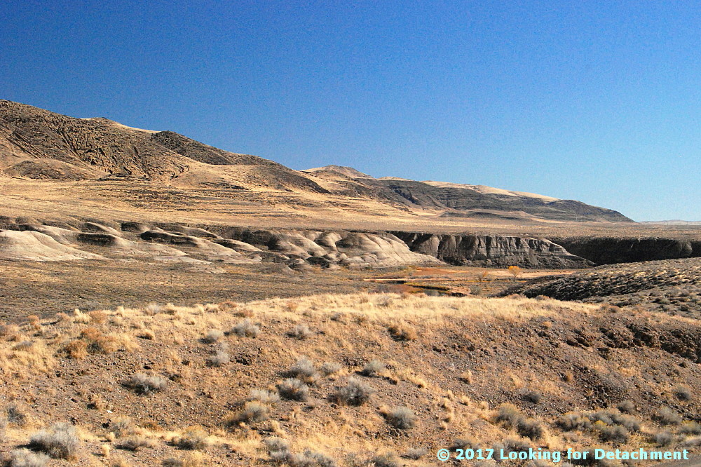 |
| I love the lone Cottonwood in this photo. |
The Walker Lane—on Google Earth (G.E.)and on other aerial representations such as air photos—shows up best at very small scales; that is, if we zoom way out and observe the area from way above, we can see the trend of the Walker Lane better than if we zoom way in, like we've done here. Nevertheless, individual strike-slip faults have been identified throughout the Walker Lane, and a few of these occur right in this area.
 |
| The A is centered on Wadsworth Amphitheater. The purple camera icon shows the location of the first photo. |
Back to the faults and linears. I do know from personal experience that Walker Lane structures pass through the Lake Lahontan sediments in the area where the Truckee is running in a particularly linear fashion. I know this from some work I did a long time ago with J.O. Davis, who was studying Lake Lahontan and using tephra beds to date various aspects of the stratigraphy. The two linears or faults in the lower right of the image cross through the area where I've seen older Lake Lahontan sediments faulted and highly contorted by the major structures that pass through the area. I can't say that my particular linears are right on the major structures, and I can see other possible lineaments.
UPDATE 3Feb2017: I now have good internet back, and I've been able to compare my "map" to a geologic map of the area (Bell, Garside, and House, 2005). My linear passing through the hatchery location (below) is spot on for their most prominent fault, which was mapped as a dominantly extensional fault.
 |
| A zoomed in G.E. view of the area. |
I sure wish Frontier was a better internet service provider! (I never had this kind of semi-routine trouble with AT&T in eastern and northern Nevada; their every-day speeds were faster, and service was (generally) provided more quickly.
Back to the photos! 😊
 |
| Horizontal Lahontan shorelines and vertical basaltic talus stripes. |
 |
| Some of the same talus stripes in Google Earth. |
 |
| This photo shows a juxtaposition of talus stripes, faint shorelines, and layered Lahontan sediments. |
 |
| White, gray, greenish gray, and pinkish layers of the Eetza Alloformation. |
Note: I usually use "formation" when talking about the subdivisions within the Lake Lahontan section, but "alloformation" is technically correct. In explanation, Bell et al (2005) say this, "Lake Lahontan and related subaerial deposits were considered lithostratigraphic units in the early studies of Morrison and were designated as formations. With the revision of the North American Stratigraphic Code in 1983, new allostratigraphic and pedostratigraphic unit definitions were added which allowed the definition of time-transgressive, lithology-independent rock units and soils."
 |
| Qsm = middle member of the Sehoo Alloformation; Qe = Eetza Alloformation. |
 |
| What I saw was more talus, more shorelines, and more Lahontan sediments. (And some fall colors.) |
Bell, J.W., Garside, L.J., and House, P.K., 2005, Geologic map of the Wadsworth Quadrangle, Washoe County, Nevada: Nevada Bur Mines and Geology Map 153.
Monday, November 28, 2016
The Left-Lateral Strike-Slip Garlock Fault Near Highway 395

 |
| I've drawn the Garlock fault with a thick blue line, and a secondary strand (air-photo linear) with a thinner blue line. |
The haze was thick and the day overcast, and it looked like the photos I was taking would be fairly lousy, but MS Photos was surprisingly able to revive the dark, lackluster originals (I usually don't rely on the Photos app, but in this case it worked better than my other free programs).
After crossing the fault on 395, I took the road toward Goler Heights and Garlock. (Goler Gulch in the El Paso Mountains at Goler Heights is unrelated to Goler Wash in the Panamint Range at the edge of Death Valley National Park.)
 |
| Looking west along the southern range front of the El Paso Mountains toward Goler Heights. |

 |
| We're now back near the junction of the Goler Road with Highway 395, looking to the northeast. |
 |
| The Garlock Fault proper is out of view beyond the low hills. |
 |
| Google Earth image with a blue line I added using the "Path" function. |
 |
| The same image with more scribbles. |
The fault has offset two drainages in a left-lateral sense; that is, the south side of the fault, moving to the northeast (right) has brought in a ridge that has blocked the dry wash in the center of the image, forcing it to flow to the northeast to get around the ridge. That ridge is labeled "shutter ridge," which is the term for a ridge that blocks a drainage in this fashion along any strike-slip fault, whether it's right lateral, like the San Andreas, or left lateral like the Garlock. A second drainage way off in the upper right corner of the image has been blocked and offset in the same fashion. That drainage appears to have two shutter ridges, one that is north of the main trace of the fault, and another that looks like it's south of the main trace (at least the way the main trace has been drawn; we can see by drawing in just a few air-photo linears that there may be a few complications, and faults often meander around a bit).
I got back onto Highway 395 and continued south toward my destination, figuring that I could get a photo looking back toward the Garlock from somewhere up near the turn-off to Randsburg. I finally found a pullout on the east side of the highway; it offered me a four-wheeling opportunity to drive a very narrow, rocky road to the top of a small hill. The photos I took from there looked really lackluster, so I didn't spend a lot of time trying to get a really good panorama. Consequently, the two photos I've stitched together below do meet up on the horizon, but they are way off in the foreground, primarily because I ended up moving to keep the dirt road I was on out of the picture. We can, nevertheless see where the Garlock and a couple parallel strands or linears are located.
 |
| Stitched photo. The center of the photo is looking just west of north. |
 |
| The same photo with a few labels. |
 |
| Looking northeast from Goler Heights along the Garlock Fault. |
Tuesday, November 22, 2016
Titus Canyon: The Klare Spring Breccia


In fact, here are some of my ideas about the placement of the upper strand (or multiple upper strands?) of the TCFZ.
 |
| An image from Google Earth approximating the first photos. |

 |
| Angular fragments of the Carrara Formation are healed by travertine. |

 |
| Looking up canyon past Klare Spring. |
 |
| The same view with some geologic labels, including a few question marks. |
And so, we've left Klare Spring, and will continue our way down the canyon...
Related Posts:
The Approach to Titus Canyon: Tan Mountain
The Approach to Titus Canyon: Up and over White Pass
The Approach to Titus Canyon: To Red Pass
The Approach to Titus Canyon: Just Below Red Pass
A Hike at Red Pass, Titus Canyon Road, Death Valley, CA
Titus Canyon Road: A Little History and a Few Maps
Down into Titus Canyon: We Leave Red Pass Behind (Finally!)
Scribbles
Titus Canyon: The Upper Part of Lost Canyon
Leadfield: Scams with a Side of Geology
Leadfield: Views from Old Mine Buildings
Leadfield: Geology...and a Cactus...on the Way Back to the Parking Area
Almost Titus Canyon: Is This a Fold? And... Apparent Dip with Post-it® Notes
Titus Canyon: The TCFZ, the FCFZ, and a few Other Faults
Titus Canyon: Another Look at the Titus Canyon Fault and A Scramble
Titus Canyon: We Make Our Way Toward Klare Spring
Location:
Klare Spring, California, USA
Thursday, November 10, 2016
Titus Canyon: We Make Our Way Toward Klare Spring

Our first photo set looks back to the east. You do remember that last time, before we stopped for our little

The cliffs on the side of the road are captivating in that they look iron stained and possibly brecciated. I think they make a great backdrop to a photo that's very similar to the first one, but which was taken on a green spring day in early May, 2009. The creosote was in bloom, and so were some cacti and other wildflowers.
 |
| I'm not sure what rock formation is exposed in this almost-always shadowed cliff. It might be Carrara, as labeled, or it might be Bonanza King. |
 |
| Here we are, a little to the north of the last spot, along an old wash channel paralleling the road, still looking to the east. |
 |
| The same photo with geologic labeling by moi. (H/t to Dana Hunter for the "moi.") |
Looking back to the first photo set, there’s a huge alluvial fan coming off the higher cliffs south of the road. On our most recent trip through the canyon in early 2016, I became fascinated by the massive alluvial fans within this part of the Grapevine Mountains. It looked like one hell of a lot of erosion to me—and probably all taking place fairly rapidly and fairly recently when the Grapevine Mountains were uplifted radically in the late late Cenozoic—and so I took a number of photos of fans, some that looked active, like this one, and others that looked older.
 |
| A steep side canyon area south of the road has filled with coarse alluvial debris, forming an alluvial fan complex. |
 |
| A closer view of part of the alluvial fan. |
 |
| A Google Earth image of the fan complex. North is not up! The magenta line on the right is the main strand of the TCFZ (extrapolated); the magenta line on the left is possibly the lower strand in this area. |
 |
| A reddish color in alluvium is often indicative of an older age. Rocks above the fan are all Bonanza King Formation. |
 |
| Google Earth image of our second fan complex; magenta lines are related to my idea(s) of the TCFZ. |
 |
| A little bit of alluvial air-photo mapping. |
I then turned to the west, zooming in to see what I thought might be some reddish talus, possibly small alluvial fans, high on the slope.
 |
| Reddish talus high on the slope below dark gray and reddish outcrops of the Bonanza King Formation. |
 |
| Here is my best guess of the geology, taken from Niemi (2012) and Google Earth air-photo interpretation. |
Meanwhile, back on the lower slopes:
 |
| Bloomin’ cactus! |
 |
| These leafy green plants were everywhere. |
 |
| Barrel cactus, yellow wildflowers, and ephedra (the olive green plant behind the barrel clump). |
 |
| Here’s another view of the same plants, with dolomite of the Bonanza King Formation as a backdrop. The ledge on the left might be the location of the upper strand of the TCFZ, just above Klare Spring. |
Related Posts:
The Approach to Titus Canyon: Tan Mountain
The Approach to Titus Canyon: Up and over White Pass
The Approach to Titus Canyon: To Red Pass
The Approach to Titus Canyon: Just Below Red Pass
A Hike at Red Pass, Titus Canyon Road, Death Valley, CA
Titus Canyon Road: A Little History and a Few Maps
Down into Titus Canyon: We Leave Red Pass Behind (Finally!)
Scribbles
Titus Canyon: The Upper Part of Lost Canyon
Leadfield: Scams with a Side of Geology
Leadfield: Views from Old Mine Buildings
Leadfield: Geology...and a Cactus...on the Way Back to the Parking Area
Almost Titus Canyon: Is This a Fold? And... Apparent Dip with Post-it® Notes
Titus Canyon: The TCFZ, the FCFZ, and a few Other Faults
Titus Canyon: Another Look at the Titus Canyon Fault and A Scramble
Monday, October 31, 2016
From the Road: Whipple Mountains
 |
| Savahia Peak in the Whipple Mountains, with cholla. |
 |
| And here's a cartoon of the geology. |
Tuesday, October 18, 2016
Titus Canyon: Another Look at the Titus Canyon Fault and A Scramble
In late February of this year, MOH and I were intent on getting down the Titus Canyon road to see the superbloom in Death Valley, which was going great guns down near Badwater. We nevertheless stopped for a hike not far downstream from the photo in my last post.
Before hiking some really steep cliffs on the north canyon wall, I looked to the south to grab a few geological photos, not realizing that besides the nice example of dipping beds, I was seeing a good example of one splay of the Titus Canyon fault zone (TCFZ).
In the labeled view below, we see the approximate line of one splay of the TCFZ. It has crossed the wash left of the photo (and in front of us in last week’s photo); it goes up, over, and back behind the foreground rocks (the arrow pointing the way); and it eventually wraps around to hook up with the low-angle fault on the more distant, shadowed hill. This interpretation of the location of a main splay of the TCFZ is from Reynolds, as seen in Lengner and Troxel (2008), and is also an extrapolation from Niemi’s 2012 map.
Disclaimers: My placement of the fault is approximate, the foreground part of the fault might be modified by a high-angle normal fault, and the cliff and hills labeled Єz may include some faulted-in Єc.
The rocks above the nicely bedded section on the right (Єc) look chaotically fractured and possibly brecciated. I read somewhere that the Fe-oxide staining of the rocks is typical of the damage zone along the fault. An unpublished map that was available from NPS in 2016, has a mélange unit devoted to certain parts of the TCFZ damage zone. That unit (TfxT; description no longer available) is reported to be particularly pronounced along the westernmost portion of the TCFZ.
MOH and I had stopped at this particular point in order to go on a smallish hike—well, we actually stopped to investigate a dry waterfall, and that investigation turned into a scramble (probably Class 3).
It turns out that this is a decent location to view the Titus Canyon fault.
And now, for a little map comparison, before we scramble up the slickrock.
My interpretation of the location of the TCFZ north of the canyon is based largely on a single photo in Lengner and Troxel (2008; their Figure 6.17, p. 114).
How do these maps line up?
I’ve corrected a bit of Niemi’s map where I think the labeling and coloring of a portion of Bonanza King Formation (his Єpb, my Єb) and Titus Canyon Formation (EOgtc) was accidentally switched. The overlay is not perfect: The programs I used (Word and Paint) are really not designed for precision. Nevertheless, we see some correlation between the two maps. Interestingly, the place where the two maps show the most divergence is right where Lengner and Troxel have their photo (where my magenta line does a lot of contortions). As far as ground checking of this TCFZ-modified Єb-Єc contact, it’s difficult to impossible to walk up to the fault in most places—at least not without using real climbing techniques or hanging oneself out of a helicopter on a rope!
Now we’ll get on with our hike!
We've now walked over to the base of the waterfall, where...we find some water!
This is as high as I got on this dry falls. MOH went up higher, probably to the TCFZ. I didn’t know there was a fault up there, or I might have been tempted to try to climb higher, even though I was about at the edge of my free-climbing competence. I scrambled back down and eventually found myself overlooking the first waterhole.
Right after taking this photo, I was maneuvering across a jutting portion of tear-a-pants limestone when I lost all but one point of contact and tumbled down toward the overhang above the pothole. I managed to recover on a smallish ledge. I was okay, but it really was close. That’s probably the last bit of free-climbing I’ll do! The DSLR fell also, hitting the rock I landed on, and somehow, it was also okay! (I was surprised. Possibly this is a testimony to Nikon.)
Our next stop will be a little farther downstream, closer to Klare Spring.
A Few References:
Lengner, K., and Troxel, B.W., 2008, Death Valley's Titus Canyon & Leadfield ghost town: Deep Enough Press, 175 p.
National Park Service (NPS) Geologic Resources Inventory (GRI) program, 20141114, Unpublished Digital Geologic Map of Death Valley National Park and Vicinity, California and Nevada (NPS, GRD, GRI, DEVA, DEVA digital map) [not available online - this link has info] adapted from a U.S. Geological Survey Scientific Investigations Map by Workman, J.B., Menges, C.M., Fridrich, C.J., Thompson, R.A. (2014).
Niemi, N.A., 2012, Geologic Map of the Central Grapevine Mountains, Inyo County, California, and Esmeralda and Nye Counties, Nevada [not available online]: Nevada, Geological Society of America Digital Maps and Charts Series, DMC12, 1:48,000, 28 p. text.
Reynolds, M.W., 1969, Stratigraphy and structural geology of the Titus andTitanothere canyons area, Death Valley, California: Berkeley, University of California, Ph.D dissertation, 310 p.
Reynolds, M.W., 1974, Geology of the Grapevine Mountains, Death Valley,California; a summary, in Death Valley region, California and Nevada, Geological Society of America Cordilleran Section, Field Trip 1 Guidebook: Death Valley Publishing Company, Shoshone, California, p. 91-97 [reprinted here].
Location map
Related Posts:
The Approach to Titus Canyon: Tan Mountain
The Approach to Titus Canyon: Up and over White Pass
The Approach to Titus Canyon: To Red Pass
The Approach to Titus Canyon: Just Below Red Pass
A Hike at Red Pass, Titus Canyon Road, Death Valley, CA
Titus Canyon Road: A Little History and a Few Maps
Down into Titus Canyon: We Leave Red Pass Behind (Finally!)
Scribbles
Titus Canyon: The Upper Part of Lost Canyon
Leadfield: Scams with a Side of Geology
Leadfield: Views from Old Mine Buildings
Leadfield: Geology...and a Cactus...on the Way Back to the Parking Area
Almost Titus Canyon: Is This a Fold? And... Apparent Dip with Post-it® Notes
Titus Canyon: The TCFZ, the FCFZ, and a few Other Faults
Revised slightly 15Jun2019 for broken or dead links.
 |
| A few wildflowers bloom in front of an orange-brown outcrop of Carrara Formation limestone. |
 |
| Beds on the south wall of the canyon are dipping in a northerly direction. |

 |
| A splay of the younger-on-older TCFZ can be seen here in hachured dark blue. It is placing the younger Bonanza King Formation (Єb) above the older Carrara Formation (Єc) and even older Zabriskie Quartzite (Єz). |
 |
| I’ve zoomed in here, just so we can see the fault exposure a little better. |
MOH and I had stopped at this particular point in order to go on a smallish hike—well, we actually stopped to investigate a dry waterfall, and that investigation turned into a scramble (probably Class 3).
 |
| We’re looking up a side drainage on the steep north side of Titus Canyon. The overexposed white areas are limestone that has been scoured and polished by running water and entrained debris. |
 |
| The Titus Canyon fault places the Bonanza King (Єb) over the Carrara (Єc). It is mostly (or entirely) behind the lower cliffs on the right side of the photo. |
 |
| A bit of Niemi’s map, from Leadfield to Klare Spring. The UTM grid lines are spaced 1 km (1000 m; 3281 ft) apart. |
 |
| A similar bit of Google Earth (GE), uncorrected for any possible skewness in orientation. The TCFZ is in magenta; other normal faults are in blue and dark blue; the Zabriskie Quartzite (Єz) is outlined in red |
How do these maps line up?
 |
| I’ve managed to overlay a transparent version of Niemi’s map on top of the Google Earth image. |
Now we’ll get on with our hike!
 |
| A small pool of water at the base of the lower chute. |
 |
| For scale, I offer a fly on the far right. |
 |
| The fly is sunning itself on polished Carrara Formation, which consists here of blue-gray limestone with orange claystone partings and wavy bedding. |
 |
| I’ve now scrambled up to a ledge and am looking up the Carrara cliff to the jagged outcrops of Bonanza King Formation (Єb) beyond. |
 |
| The faults drawn in are mostly hidden from view by the jutting lower cliff of Carrara Formation (Єc). The TCFZ, in hachured dark blue, is offset by a high-angle normal fault in lighter blue. |
 |
| I love barrel cacti! |
 |
| I’ve now scrambled even higher, to stand below a second polished chute. |
 |
| The third polished chute, even higher, is above a large, dry plunge pool. |
 |
| I stand on a ledge above the first pothole. |
Our next stop will be a little farther downstream, closer to Klare Spring.
A Few References:
Lengner, K., and Troxel, B.W., 2008, Death Valley's Titus Canyon & Leadfield ghost town: Deep Enough Press, 175 p.
National Park Service (NPS) Geologic Resources Inventory (GRI) program, 20141114, Unpublished Digital Geologic Map of Death Valley National Park and Vicinity, California and Nevada (NPS, GRD, GRI, DEVA, DEVA digital map) [not available online - this link has info] adapted from a U.S. Geological Survey Scientific Investigations Map by Workman, J.B., Menges, C.M., Fridrich, C.J., Thompson, R.A. (2014).
Niemi, N.A., 2012, Geologic Map of the Central Grapevine Mountains, Inyo County, California, and Esmeralda and Nye Counties, Nevada [not available online]: Nevada, Geological Society of America Digital Maps and Charts Series, DMC12, 1:48,000, 28 p. text.
Reynolds, M.W., 1969, Stratigraphy and structural geology of the Titus andTitanothere canyons area, Death Valley, California: Berkeley, University of California, Ph.D dissertation, 310 p.
Reynolds, M.W., 1974, Geology of the Grapevine Mountains, Death Valley,California; a summary, in Death Valley region, California and Nevada, Geological Society of America Cordilleran Section, Field Trip 1 Guidebook: Death Valley Publishing Company, Shoshone, California, p. 91-97 [reprinted here].
Related Posts:
The Approach to Titus Canyon: Tan Mountain
The Approach to Titus Canyon: Up and over White Pass
The Approach to Titus Canyon: To Red Pass
The Approach to Titus Canyon: Just Below Red Pass
A Hike at Red Pass, Titus Canyon Road, Death Valley, CA
Titus Canyon Road: A Little History and a Few Maps
Down into Titus Canyon: We Leave Red Pass Behind (Finally!)
Scribbles
Titus Canyon: The Upper Part of Lost Canyon
Leadfield: Scams with a Side of Geology
Leadfield: Views from Old Mine Buildings
Leadfield: Geology...and a Cactus...on the Way Back to the Parking Area
Almost Titus Canyon: Is This a Fold? And... Apparent Dip with Post-it® Notes
Titus Canyon: The TCFZ, the FCFZ, and a few Other Faults
Revised slightly 15Jun2019 for broken or dead links.
Subscribe to:
Posts (Atom)