Showing posts with label 8A. Show all posts

Sunday, June 12, 2022

The northern section of Highway 8A

Signs at the turn-off from westbound 140 to SRs 8A and 34A
Well, I finally did it! I traveled the northern section of Nevada S.R. 8A, which runs from the NV-CA stateline east of Cedarville, CA, to Nevada S.R. 140, the Winnemucca-to-the-Sea Highway. I posted earlier about the west end of northern 8A here, here, and here. The northeast end of northern 8A was covered briefly in this post, which is part of a series about Highway 140. The traverse described in this post was part of a larger loop trip from northern Nevada to northern California, the westbound portion of which is shown in this map (also embedded at the bottom).
Take the left fork to stay on 8A, or the right fork for 34A.
Looking southeast across Echo Creek at Gooch Table.
Volcanic tableland in the foreground. The Pine Forest Range is on the right; the Pueblo Mountains near Denio are on the left.
The sky was overcast for much of the trip, so the photos I got were not as good as they might have been on a bright summer day. Wildflowers were out—not a superbloom but quite persistent and with numerous species—and I saw three pronghorn in the west-central part of the Sheldon National Wildlife Refuge.
One pronghorn barely visible. The south end of Gooch Table is to the left; the hills beyond the pronghorn are northern slopes off Fish Creek Mountain.
As the northern slopes of Fish Creek Mountain came into view, the area started looking familiar, and I wondered if I'd bushwhacked through the mountain mahogany on Fish Creek Mountain during a long-ago deer-hunting adventure. Also, I was now coming into the area where the Stolpas got in trouble in the winter of  '92-93. Beyond the pronghorn in the photo above, more or less just beyond the area between that dark volcanic flow and the mountain-mahogany-covered hills, the land slopes east into the upper drainage of Hell Creek, where Jim and Jennifer took refuge in a small cave approximately two miles east of Blowout Mountain. Hell Creek drains into Virgin Creek, eventually into the area of the Virgin Valley opal mines, where they might have found people, had they been able to continue their long trek through the snow. Instead, Jim walked 40 miles or so to Vya, where he luckily found someone at or near the road maintenance station.
Two pronghorn.
The road, 8A, is wide and graveled, quite smooth over most of its length, though it was decidedly dusty. At the north end, the gravel included oversize rocks that make for a rough ride in places. I had the AC on high and recirculate throughout the dirt portion of my trip (from NV 140  to CA 299) to keep the cabin pressurized; otherwise I was breathing in a lot of dust. Every time I'd stop, the dust would move over me from the rear, and I'd have to wait to take photos. The dust, in the mostly still air, was drafting along with the Jeep in lieu of any wind blowing it to one side or the other. By the way, it's always good to check your air filter after a trip through such volumes of dust, or even during if the silt is particularly nasty.
Mesa at the south end of Fish Creek Table.

And then, having passed from northwestern Humboldt County to northern Washoe County, and having also passed out of the Sheldon National Wildlife Refuge, I finally turned onto a side road for lunch. Lunch was accompanied by a short wildflower walkabout.


Moving on from lunch, I came to the fast, western section of road approaching Vya. Finally, the sun came out.

Looking west toward Vya: The playas of Middle & West Lakes are in the center, with Massacre Lake behind the hill on the right. The dark knob on the left is Painted Point.
The 8A portion of the larger trip, from its junction at the north end with Nevada S.R. 140 to the NV-CA stateline where the road becomes CA 299, took about two and a half hours, including several brief photo stops and a 20-minute lunch stop. Google has one traveling that route (63 miles) at an average speed of 18 mph, whereas my average speed including more than 20 minutes of down time, was 25 mph. Before leaving, I had calculated that Google was giving me a rate of 17 mph just for the 140 to Vya section, but apparently they think the entire 8A section is a drag. In winter, of course, one might not be able to traverse the road at all, what with all that volcanic-derived silt turning to sticky, slippery mud, or the plateau country becoming buried or drifted during any serious snowstorm.
Wildflowers near the junction of 8A and 34 south of Vya.
As mentioned earlier, I've been up in the Sheldon country before, most notably many years ago for black powder deer hunting. We were probably somewhere over in the Fish Creek Mountain – Blowout Mountain area, or perhaps a bit to the south down near Mahogany Mountain.

More about 8A at LFD:

Note: a few photos shown on the map didn't make it to this post.

Tuesday, September 1, 2020

Northumberland via old Highway 8A

Before I get very far into this blog post, I have to say that the Blogger interface, with its recent "upgrade," now sucks due to sudden changes in the way the HTML works. First off, the code for each photo is different than it used to be, such that I have to go back to older posts to duplicate spacing at the top, bottom, and left margins. I mean, I guess if I was 100% prolific with HTML, I wouldn't have to do that, but every time they’ve done one of their upgrades, I’ve had to modify the way I enlarge the photos to the right size, and have to recreate or copy the HTML that controls the way my photos display—and quite frankly I do give a damn!

Back to our trip. As I mentioned earlier, it was hot, so I didn't stop very often on my trip down old Highway 8A (now S.R. 305) from Battle Mountain to Highway 50 near Austin, en route to the Northumberland caldera. I did, however, make a point to stop at an old stone house along the Reese River—possibly the original Walters Ranch, though the USGS map shows the ranch down in the green valley closer to the river.
The old place is holding together fairly well, though it looked a little more rundown than the last time I stopped.
A closer view of the entry area, with quite a bit of carved graffiti.
An old rusty stove sits in the ruins of the old stone house, below the caved-in roof and amidst the partly discombobulated walls (stove = dark patch in lower right of photo).
The roof has slumped more than the last time I stopped, which might have been as long ago as 2012. The meadow beyond—the valley of the Reese River between the Ravenswood mountain range on the west and low hills that lie more or less between the Shoshone and Toiyabe Ranges on the east—is often quite green; here it's looking a tad dried out.

At 12:29 pm, toward the end of my little stop, it was 96°F.
A little farther south I drove past the location where FMOH and I canoed meanders of the Reese River back in 2006. This time, the meanders were choked with dark green sedge and the river was too narrow for a canoe. 

My next stop was Austin, for gas. I prefer to be fully fueled when traveling the back roads of Nevada. After fueling up, it was up and over Austin Summit on Highway 50, then up to Bob Scott Summit, where I stopped briefly for a pit stop and to consider Bob Scott as a campsite. But no, I wanted to keep going. Scattered clouds hovered overhead, and a light sprinkle hit the windshield. At 1:20 pm the temp was 84°F.

Beyond Bob Scott, it was downhill to the turn off on old 8A (now S.R. 376) into Big Smoky Valley. I thought about the old camp on Bowman Creek as a possible camping location, but blew that off. I was shortly at the turnoff to Northumberland Canyon.
In this photo, taken just past the turnoff from pavement, Northumberland Canyon is almost 12 miles across Big Smoky Valley as the crow flies. The mountain range that we're looking at, on the east side of the valley, is the Toquima Range; the singular mountain to the right is Mount Jefferson, third most prominent peak in Nevada. I've been to about 11,400 ft near the North Summit. The South Summit reaches 11,941 ft.
I arrived at the western mouth to West Northumberland Canyon at about 2:30 pm and pulled off on a side road where I had a relatively elevated view of Big Smoky Valley and the Toiyabe Range beyond. A low area in the mountain range (just left of center in the photo above) marks the drainage basin of Kingston Creek. The tiny town of Kingston sits on Kingston Creek, right at the range front. Bunker Hill, the rounded peak right of the low spot, reaches 11,473 feet in elevation.

* * * * *

2:45pm: It's now 92°F. I just walked a short ways up the dirt road behind the Jeep, thinking I'd check the road to the range front, but I gave that up for the heat. Instead, I'm sitting next to the Jeep in a lawn chair, enjoying the view. A few clouds overhead look threatening—possible T-storms. I won't cross the flash-flood prone Northumberland Canyon dry wash until...well, hopefully the clouds will dissipate. The crossing right now would be perfectly fine, but if the canyon floods, I'd be stranded on the other side. A long time ago, there was a road across Big Smoky Valley going back to 8A north of Kingston, providing a possible escape route if stranded; I have no idea if that road exists anymore.

There was a huge wipe out of a flash flood in West and East Northumberland Canyons back in 1979. Heavy barite ore from the small mine on the west side of Northumberland Pass was washed down canyon, as was a USFS truck. Fortunately no one was inside the truck.

Back in 1978, in the reddish hills across the dry wash of West Northumberland Canyon (behind the Jeep in the photo above, or somewhere in the low part of the reddish hills in the photo below) I left a standard Estwing rock hammer leaned against an outcrop of tuff as scale for a photo. I've looked for the hammer a couple times, both before and after the mega flash flood of 1979. I suppose it's part of the drainage, downstream somewhere. But who knows? Maybe it's still there, leaning against the outcrop.
The reddish brown tuff of Hoodoo Canyon, 31.4 Ma, overlies whitish volcanic and volcaniclastic rocks that include Ts6, an air-fall tuff related to the tuff of Hoodoo Canyon, and Ts5, 4, and 3—and possibly Ts2 and 1—which are all intracaldera sediments deposited after the partial collapse of the ~32 Ma Northumberland caldera and before deposition of Ts6.

2:53 pm: I've frequented this valley, these parts, since before 1978. In fact, the first time I camped in the area was up on Pete's Summit in 1976, after seeing the Ordovician graptolites in the Vinini Formation while on a grad school field trip. It's my country, I feel, and if I had a house up here on this pediment, I'd sit outside and stare at the basin, the way I did back in 1979-81 when the company put me up in a small cabin above Kingston. There's usually no no one around for miles, for at least ten to fifteen miles. The view is awesome.

It's 4:27 pm now,
and I've crossed the wash and moved to the site we used to call the Hot Spot, so named for it's anomalous gamma radiation and U3O8 minerals. From the camp I've chosen, I can look northwest toward Kingston Canyon, east into Hoodoo Canyon, and south toward Northumberland Canyon. The wind is coming in from the northwest, and it's 91° F in my little camp. It's five hours to sunset according to the hand method, though at five hours away, the method is grossly inaccurate.

4:51 pm: I'm cracking an All Day IPA. Until the sun is lower, I won't set up camp more than I have already, which is only to remove the ice boxes, the water cooler, and folding chair. I'm somewhat low on ice, and the beer isn't the coldest beer in the world, but it's refreshing. And now the sun has come out from behind those formerly threatening clouds, so I've moved into the shade of the Jeep. A tree would be nice!

* * * * *
As the sun got lower, I drank my cool beers and had a minimalist dinner of chips and dip. The sun finally went behind the clouds hovering over the Toiyabe Range. I watched the sunset colors change, took many photos, marveled at the yellow-orange crepuscular rays, took more photos, and basked in the quietude of the area.
Virga and a cliff of Northumberland Tuff glow reddish orange.

I had another beer or two and took more photos. At some point, the sun went down, but with the Toiyabes in the way and no connection for my cell phone, I could only estimate the time of actual sunset, guessing it to be about 8:05 pm. According to SunCalc, the sun set at 8:10 pm at my campsite. The hand method referenced earlier gave a time of about 9:25 pm—off by almost an hour and a half! (It's more accurate within one to three hours of sunset, especially when there aren't any mountain ranges looming above the true horizon.)

By 8:43 pm, I had my headlamp on, using the red light setting. It was way warm for sleeping, but I didn't check the temperature by turning on the Jeep. Overall, it felt strange to be camped there in the middle of nowhere during the middle of a summer heat wave. And for some reason, I felt creeped out by a long ago memory of a lone mountain lion in the Toquimas, so I didn't want to sleep outside the Jeep, making for a night that was hotter than necessary. Eventually, I slept, albeit restlessly.

Tuesday, August 23, 2016

Tertiary Tuesday: Hoodoos along Old 8A in Northwestern Nevada

Last week we saw some hoodoo-ish rock formations on a hill behind the road maintenance station at Vya. Let's take a closer look:
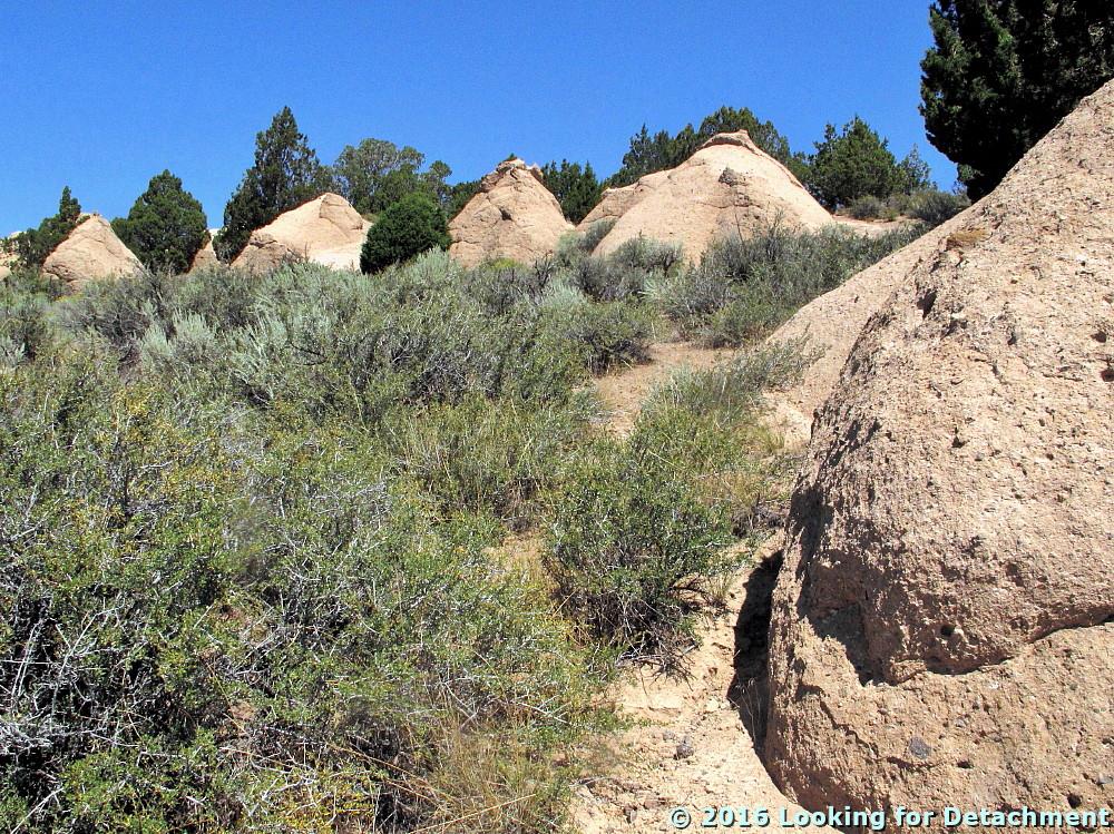
When we zoom in on these particular hoodoos, we see that they are shaped much like the "tent rocks" in the Kasha-Katuwe Tent Rocks National Monument in New Mexico, and though close to the ground, they also look a lot like the hoodoos, tent rocks, and "fairy chimneys" at Cappadocia in Turkey. Notice the softer, pinkish part of the section near the base of the the central and most fully exposed hoodoo, the white caprocks or "tents" all across the hill, and the darker-colored outcrops near the top of the hill. This outcrop pattern of light-colored rock beneath darker rock is typical of many ash-flow sheets in Nevada, and that's what this most likely is: a poorly welded (bottom) to maybe moderately welded (top) ash-flow-tuff cooling unit.

From Vya, as you remember, we drove south then west onto old Highway 8A (now a county road, possibly still called 8A), and started climbing over an unnamed pass through the Hays Canyon Range. MOH and I hoped we would see some of these hoodoos up close, and sure enough, when we rounded a bend one was sticking out right next to the road!
We pulled over quickly and walked up the hill.
These rock formations (above and below) have an incipient tent-rock shape, with a tiny capping of a harder, more weather-resistant layer near the top. I suspect that these budding hoodoos correlate with the "tent" part of the hill we saw near Vya, where more of the geologic section was exposed.

The weathered form above is similar to some shapes one might see in weathered granite. This particular type of shape—gently rounded or sub-spheroidal—is not uncommon in some ash-flow tuff units, hence the name "granite-weathering tuff" for part of at least one regional ash-flow sheet in south-central Nevada.

Let's get closer:
Here's a fairly large, subrounded lithic fragment within the tuff.
Zooming in a bit, we see that the matrix of the tuff is fairly fine-grained, fairly well-sorted, and some grains look sharp and appear to be interlocking.
It would be fairly easy from this one photo (above) to convince oneself that the matrix was pumiceous and glassy.
Here's another view of the rock: Rounded to sub-rounded lithic fragments and white pumice float in a fine-grained matrix.
I'm pointing to one of the white pumice fragments in this enlarged view.
I had a harder time, after looking at this second example of the exposure, convincing myself that this was unwelded or poorly welded pyroclastic flow rock (ash-flow tuff—same diff). The second closeup shows scattered rounded to subangular dark-colored and white lithic fragments and fairly small to fairly large white pumice in a dirt-colored matrix of subrounded, fine-grained pebbles, lithics, or pumice and glassy-looking particles. This photo could be of a reworked tuff or a lithic-rich or lapilli tuff of unknown origin. Are the pale orange, subrounded fragments pebbly lithics or rounded pumice? If pumice, are they primary, deposited in either an air-fall or ash-flow type of environment, or have they been rounded by reworking in some type of fluvial or colluvial environment? (Your thoughts are welcome.) The two photos, the first with the large lithic and the second with the white pumice, were taken within a few feet of each other.

Standing back and looking at the overall mien of the outcrop, I'm going to have to stick with poorly welded ash-flow tuff.
I tried to find out about the geology of the area and found this one geologic map by Egger (2010), a regional map focusing largely on the Warner Range to the west but also including part of the Hays Canyon Range. According to the map and accompanying text (both are available for download here), these hoodoos and rock formations occur in what has been called the Fortynine Tuff by Carmichael et al (2006) in an article I didn't access (paywall).
I noticed (after the fact) a couple intriguing joints within the tuff, including two that might have veins of some sort or slickensides (the upper, center one in shadow, and one just below it and to the right, also in shadow).
Egger references an age of 26.26 ± 0.13 Ma (Egger, 2010; Egger and Miller, 2011) for rock just a little north of this exposure, rock included in the Fortynine Tuff of Carmichael et al (2006) and mapped as unit Tovu by Egger (2010): This tuff is Oligocene in age.

A Few References:
Carmichael, I.S.E., Lange, R.A., Hall, C.M. and Renne, P.R., 2006. Faulted and tilted Pliocene olivine-tholeiite lavas near Alturas, NE California, and their bearing on the uplift of the Warner Range [abs link]: Geological Society of America Bulletin, v. 118, no. 9-10, p. 1196-1211.

Egger, A.E., 2010, Geological history and structural evolution of the Warner Range and Surprise Valley, northwestern margin of the Basin and Range Province [Ph.D. thesis]: Stanford University, 180 p. Plate1.

Egger, A.E., and Miller, E.L., 2011, Evolution of the northwestern margin of the Basin and Range: The geology and extensional history of the Warner Range and environs, northeastern California: Geosphere, v. 7, no. 3, p. 756-773.

Tuesday, August 16, 2016

One Year Ago Today: A Short Trip on Highway 8A in northern Washoe County — and Hoodoos!

A year ago, MOH and I were out on a two-day road trip that was designed to take us to the section of old Nevada S.R. 8A that has long been rumored to still be signed, though it is no longer shown on state road maps as 8A, nor has it been since 1981. To accomplish our goal, we drove north out of Gerlach on old S.R. 34 (now Washoe County C.R. 34). It's about 85 miles from Gerlach to Vya, a small outpost consisting mostly of a Washoe County road department building or two and some private ranches.

Strangely enough, Google Maps won't let me make a connection from Gerlach to about 5 miles north of Gerlach on C.R. 34 without routing me either all the way over to Cedarville, CA, or taking me down an obscure and suspiciously narrow-looking dirt road.
The route above doesn't start in Gerlach, because it can't. The route below, starting in Gerlach, won't go exclusively on C.R. 34, because it won't.
After 3 hours of driving (driving and stopping, driving and stopping), we ended up at this junction with old 8A:
The junction of old S.R. 34 and old S.R. 8A in northern Washoe County.
At this point, we turned right to see what we might find.
An 8A sign, up ahead!
This is actually a "To 8A" sign! It's pretty well marked for a road that no longer exists, I'd say!

A little ways on, around a bend taking us back to the north, we came to another junction, one with several signs.
A small sign forest appears at the junction of conjoined 34+8A and 8A, which turns off to the east.
Here's another "To 8A" sign. Turn east just ahead.
Vya is now shown as being a mile to the north on continuing C.R. 34, and the sign says you will reach Denio or Winnemucca in many miles if you turn right.
The rest of the signs at the second junction are the back side of a yield sign, a BLM sign pointing to unreadable destinations, and a "To 34" sign beyond that.
We turn right, of course, so we will be able to say we drove onto the northern leg of old Highway 8A. Now, what do those signs say?
This is 8A. It's signed. The sign doesn't say it's a county road.
"Road not regularly maintained. Travel at your own risk. Closed during winter."
This warning sign was put in place sometime after the infamous Stolpa incident back in late 1992 – early 1993 (some links here).
There's the jeep, barely on 8A, back at the junction with 34. Oh, and look: hoodoos!
We drove north on C.R. 34 to the maintenance station at Vya. Apparently if we had driven a little farther north, we'd have been at the site of the old town of Vya, now a ghost town.
There's a good batch of hoodoos in volcanic rock on the hillside behind the maintenance station. Don't ever plan on getting gas at Vya! There isn't any!!
Having met our defined goal of reaching the northern portion of old Highway 8A, we turned back to the south. From the junction up ahead (the one we turned east on briefly), to the CA state line, we will be on old 8A, and for a short distance, also on old 34. Highway 34 wasn't even a marked road until sometime after 1939, whereas 8A was on maps as early as 1929 (a few maps and links here).
We head south on 34, which will turn into unmarked 8A (combined with 34) at the junction just ahead.
Now we've rounded that first bend and are back at our first junction. We'll head west on unmarked 8A. There may be hints of hoodoos on the far slope.
Now we've crossed over an unnamed pass in the Hays Canyon Range, and are nearing the NV-CA border.
There was a profusion of sign at the border, but no sign marking 8A going back into Nevada.
We stopped at the stateline to see if the sign that had marked 8A would still be there, but it wasn't. Gravel turned to pavement, old 8A became CA 299, and we drove on down into Surprise Valley, which wasn't looking very green a year ago today.