Showing posts with label majuba. Show all posts

Tuesday, June 20, 2017

High Water Across the West: Rye Patch Dam and the Humboldt Sink

Rye Patch Dam on April 19th. The water in Rye Patch Reservoir is high, but not at the high water mark that can be seen just past the spillway.
I'm moving slowly on this mini-series about the Humboldt River while working essentially 12-hour days and while (hopefully) recovering from some long-lasting bug I caught on the road or out in Elko more than two months ago. Also, my current work schedule of  9 to 10 days in a row gives me 2 to 3 days off that don't involve driving, so my off days tend to be filled with chores and not that much writing. Anyhoo, there I was traveling south on I-80 past the big bend at Humboldt Station, where I had stopped to take a few photos of the water in the Pitt-Taylor Reservoirs, when I decided—rather spontaneously—to drive down to Rye Patch Dam. As you can see from the first photo, the reservoir is high, but not quite to the high water mark.
Rye Patch Reservoir and Majuba Hill.
Here we're looking just west of north across a shallows, and we can see Majuba Hill just right of center in the distance. The main, deeper part of the reservoir is long and linear where it follows a canyon cut by the river into Lake Lahontan sediments.
The same view in June, 2016, from Google Earth.
A few Western Grebes swim in the shallows.
A closer view of one grebe.
I couldn't resist this view of the Humboldt Range.
Snow-capped Star Peak hides behind clouds. The Cordex Pit of the Florida Canyon Mine operations might be barely visible below Star Peak.
After my brief sojourn at the Rye Patch Dam overlook, I proceeded back to the interstate, speeding ever southward and then southwestward as the road made another broad bend near Lovelock. I was shocked at what I saw when I drove past Granite Point.
The Humboldt Sink had water in it!
At first, I thought it might be a mirage, and although these photos don't really do justice to it, it was indeed water, a small lake that has persisted, at least through my last drive by the area a week ago on June 11th.
A closer view of the Humboldt Sink and the West Humboldt Range.
And that's all for now, time for work! I've got a few pictures of even more water from another trip, but I can't promise when I'll get to it!

Tuesday, May 30, 2017

High Water Across the West: The Humboldt River at Winnemucca and Humboldt Station

When I started putting these photos together—while thinking about our last post about the Humboldt River in Carlin Canyon—I somehow (and quite erroneously) figured I could throw a whole bunch of high-water Humboldt River photos together in one blog post. The thing is, I have way too many, from several different localities and a few different days, and I hope to collect a few more before the water ebbs. So for today, we'll stick with these two spots, which I visited while driving I-80 from Elko to Reno on April 19th. The first shot looks westward toward Blue Mountain from the westbound exit onto West Winnemucca Blvd (exit 176).

The flooding in Winnemucca was really quite extensive when I drove through on April 11th (no photos) and then again on the 19th: several backyards and a few basements or first floors of houses near the defunct "Barrick Arms Apartments" were under water. The water had receded incompletely when I saw it last (May 28th).

These first pics show the Humboldt River's floodplain looking more like a marshy lake than it's usual dry self. Water level was slightly lower on April 19th than when I first saw it on the 11th.
Here's a phone-camera panorama, with Blue Mountain way off on the left and Winnemucca Mountain taking up the right half of the photo.
This Google Maps Street View image, a flashback to 2011, shows a more typical appearance of the same panorama, albeit from October rather than spring.
And just because, I've included a picture centered on Winnemucca Mountain. It's a prominent feature and a landmark for miles and miles. If you look closely, you'll see the two-toned "W" painted on its southeastern slope.

On that same day (the 19th), I pulled off I-80 at Humboldt House (exit 138, marked "Humboldt") and drove old Highway 40 back toward Imlay.
I crudely spliced together two or three photos looking northwest across what I thought was Rye Patch Reservoir.
It turns out that the entirety of the water seen in these photos is contained within the Upper and Lower Pitt-Taylor Reservoirs.
Here we see Majuba Hill behind blue water in the Lower Pitt-Taylor Reservoir. The light beige horizontal line between the water and Majuba are bluffs underlain by Lake Lahontan's Sehoo Formation. A narrow part of Rye Patch Reservoir proper runs between us and those bluffs, but we can't really see it, even though the water is running high.
Here we can see both the Lower and Upper Pitt-Taylor Reservoirs. The Lower is closest to us; the Upper is beyond the horizontal pale beige line separating the two bodies of water. The wide upper part of Rye Patch Reservoir lies not far beyond the Upper Pitt-Taylor, hidden from us by some irregular low hills. Off in the distance, we're looking at pointed, snow-covered King Lear Peak, part of the Jackson Mountains. The 8923-foot-high peak (2720 m) is about 45 miles away.

Thursday, December 11, 2014

Twelve Months of LFD 2014

I missed this retrospective meme last year (as I also did in 2011), but here it is, back again, per DrugMonkey:
The rules for this blog meme are quite simple.
-Post the link and first sentence from the first blog entry for each month of the past year. I originally did this meme, after seeing similar posted by Janet Stemwedel and John Lynch. Prior editions include 2012201120102009 and 2008.
Previous takes on this Twelve Month meme at LFD were posted for 2008, 2009, 2010, and 2012. As usual for LFD, I've also added the accompanying first photo of the month, where there was one with the first post of the month, and a gratuitous sign photo for October.

So, here's the year 2014 for LFD:
January:
I'm sitting here inside flight 112--I think--with my phone in airplane mode, wondering if I can create a blog draft that I can save and post later.

February:
We've been having unsettled to stormy weather here in western Nevada for about the last week, with at least light snow accumulating in the mountains, though the south facing slopes have gone back to being mostly bare, even under today's cloudy skies.

March:
Flying back from Alaska on yet another recent trip, I was able to spot Rose Spit, which featured as Where in the West challenge back in October of 2010.

April:
A while back, I started collecting photos of Majuba Hill (AKA Majuba Mountain), partly because I pass by daily on the way to and from work, and also because of it's interesting shape and fascinating geology (which I hope to learn more about on this spring's GSN field trip).

May:
MOH and I will shortly be off on a field trip to a few nearby localities, including Majuba Hill, reportedly a great mineral and rock collecting site, seen here from I-80 looking northwest across Rye Patch Reservoir.

June:
Here are a few photoviews from Majuba Hill, while I get it together to take some rock photos:

July:
A quick report on a canoe trip we took recently:

August:
So, while I wasn't thinking about it, my 1000th post posted, and this is my 1005th! I'm not sure, really, what to say about this — although I'm also sure I'll think of something — other than Yay!!

September:
The sun is about to rise through thick smoke blanketing the
southern Humboldt Range.

October: A colleague of my former (deceased) husband once said, "Archaeologists are the Cowboys of Science."
[He was wrong, btw. Read the post to find out why.]

November:
So there I was, traveling west on I-80 late last week — just after our first rain sans snow (except for at the high elevations of a few mountains east of the Sierra, like the Humboldt and Sonoma Ranges, which top out at 9836 and 9396 feet respectively), and before our most recent larger rain and snowstorm of this past weekend — when I came to the marshes that border the west end of the Fortymile Desert.

December: MOH turned me on to this song just yesterday (I didn't listen to much besides classic rock and country in the 80s).


Sammy Hagar: I Can't Drive 55 (lyrics)
Album: VOA, 1984

Monday, August 25, 2014

Rhyolite Porphyry from Majuba Hill III

GSN field trip Day 2: We've taken a few Majuba Hill samples out of the bag.
We'll now take a look at the farthest right sample, having already seen
Rocks #1 & #2 and Rock #3.
One side shows a weathered surface, with dark brown iron oxides and the copper carbonates malachite and azurite.
I suspect that the reason I picked up this rock was because of the mineralized appearance of the outer surfaces. I probably had no idea this rock would turn out to be yet another sample of rhyolite porphyry when I grabbed it off the dump. Scratching the iron oxide reveals it to be goethite mixed with jarosite — according to the old Bear Creek porphyry copper exploration method matching oxide color to a complex triangle of powdered goethite, hematite, and jarosite with mixes in between. The only partial example I can find of this method online can be seen here.
A fresh surface of the same rock.
Zooming in on the fresh surface, we can see that we indeed have yet another sample of rhyolite porphyry: 
Although the former feldspar phenocrysts are nearly completely gone to black tourmaline needles with a scattering of brown iron oxides (goethite + jarosite) and greenish to blue-green copper minerals, the gray, fresh-looking quartz eyes are clearly recognizable.
What's really interesting about this rock is the white to gray matrix.
The matrix of this current hand sample is considerably more altered than that of our previous sample, Rock #3: The matrix is shot through with tiny tourmaline needles and finely disseminated sericite. Additionally, the tourmalinized feldspar sites within this rock contain only minor copper minerals when compared to the feldspar sites of Rock #3. I was a bit surprised at this lesser amount of copper after spying the obvious blues and greens of copper minerals on the weathered surfaces.

And here's another surface of the rock, one showing a moderate amount of reddish brown iron-oxide (hematite + jarosite), a pale bluish green copper mineral (or combo of minerals), and black tourmaline.
The iron oxides are very fine-grained and powdery, and from a few boxworky textures, I'd say that they at least in part replace former sulfides (probably copper sulfides judging by the color of the iron oxides). Quartz phenocrysts are visible in the light olive gray right hand side of the sample (these are easier to see in person with a hand lens than in this photo because of the shadows in the photo).

And that's the last of our rhyolite porphyry samples, at least of those that haven't been brecciated!

Rhyolite Porphyry from Majuba Hill I
Rhyolite Porphyry from Majuba Hill II
Rhyolite Porphyry from Majuba Hill III (this post)

Wednesday, August 20, 2014

Rhyolite Porphyry from Majuba Hill II

GSN field trip Day 2: we're still at Majuba Hill.
Continuing with our progression from left to right of rhyolite porphyry hand samples, we move on to Rock Number 3, a weakly mineralized version of the tourmalinized porphyry. (Rock 1 and 2 were seen here.)
The feldspar sites in this rock sample contain needles of tourmaline, and powdery white sericite with a soft, blue green copper mineral.
An enlargement of the left part of the same photo.
I'm unclear as to the timing of mineral deposition in the altered, mineralized feldspar sites. Which came first, the tourmaline, the sericite, or the copper minerals (all after the original feldspar phenocrysts)?

The blue, green, and turquoise-colored copper minerals include at least include one spot of azurite, a few spots of possible malachite, and widespread possible chrysocolla — but at Majuba Hill, there are several bluish to greenish copper minerals that might be present (see this mineral list for Majuba Hill), including parnauite and goudeyite, both of which were first identified at Majuba Hill.
Another view of the same rock - this time the right part (turned sideways).
Which came first? I'm still wondering. Maybe we could use some thin sections (not that I have any to offer, sorry).

We'll move on to the highly altered rock on the far right (second photo) in a third episode.

Monday, August 11, 2014

Rhyolite Porphyry from Majuba Hill I

I'm just now getting back to my Majuba Hill series, wherein I'm posting some photos from the spring GSN field trip and some related rock photos. And for those just catching up, the series begins loosely with this first unplanned stop. It then continues with a Keep Out sign, some views of the Middle adit, and some views from the dump at the Middle adit. It then goes on to our first look at the rhyolite porphyry.

What we have today are a few rock specimens — four to start with.
Tourmalinized rhyolite porphyry from Majuba Hill: two fairly "fresh" or unmineralized samples on the left, and two mineralized versions on the right.
The first sample: a weathered surface of tourmalinized rhyolite porphyry. Tourmaline has replaced the feldspar phenocrysts, or filled voids left by the earlier leaching of feldspars, and left only the quartz eyes.
The second sample.
In this second sample, some of the tourmaline in the feldspar sites can be seen to be intergrown with sericite — a very fine-grained, white mica (sericite is usually compositionally the same as muscovite), which in this case formed by hydrothermal alteration.
A second look at the second sample.
The tourmaline mass in the center of this sample contains some reddish brown iron oxides formed after now oxidized and partly leached sulfides. The tourmaline mass below and a little to the right of center shows an example of tourmaline with sericite.

We'll take a look at the next two samples some other day.

Tuesday, July 22, 2014

A Trinket from Majuba Hill

Rhyolite from Majuba Hill, in the shape of Nevada (a pin).
As per this little blurb (above) by the NBMG, tourmaline (the black mineral) has replaced the sanidine and plagioclase feldspar phenocrysts, leaving small blobs and fairly large eyes of translucent and very light gray to faintly yellowish or tan quartz amongst the often large masses of tourmaline. The one tourmaline mass or crystal near the center of Nevada — right about where Kingston Canyon, south of Austin on old Highway 8A, would be — retains the shape of a feldspar, probably a K-feldspar (sanidine).

Surprisingly, not all rhyolite porphyry from Majuba Hill comes in the shape of Nevada.

Wednesday, June 25, 2014

Blogging from the Road

So, I thought I'd once again try blogging from the road, in this case the road to work (I-80, and what better way than with this phone shot of Majuba Hill).

This is a fairly difficult proposition on the phone while traveling in the back seat of a mostly comfortable truck, partly because of the awkwardness of punching out letters on the virtual keypad, partly because I can't really get an accurate preview of the post.

Monday, June 9, 2014

Views from Majuba Hill

Here are a few photoviews from Majuba Hill, while I get it together to take some rock photos:
Wooden structure (trestle and ore bin?) on the mine dump of the Middle adit.
Mindat has a photo showing what the above structure looked like in 1970, although the angle isn't great. At that time, the entrance to the adit was wooden (current view of the adit entrance at my previous post). You can see a good side view of the structure here (photo also from Mindat), as it looked in 1980. According to one source, there may have been a 1000-foot-long tramway leading from this site to an ore bin. I have a couple ideas where this could have run; maybe I'll get a chance to post the ideas later.
View looking off  toward the Humboldt Range.
Looking across an upper part of Rye Patch Reservoir at the Humboldt Range.
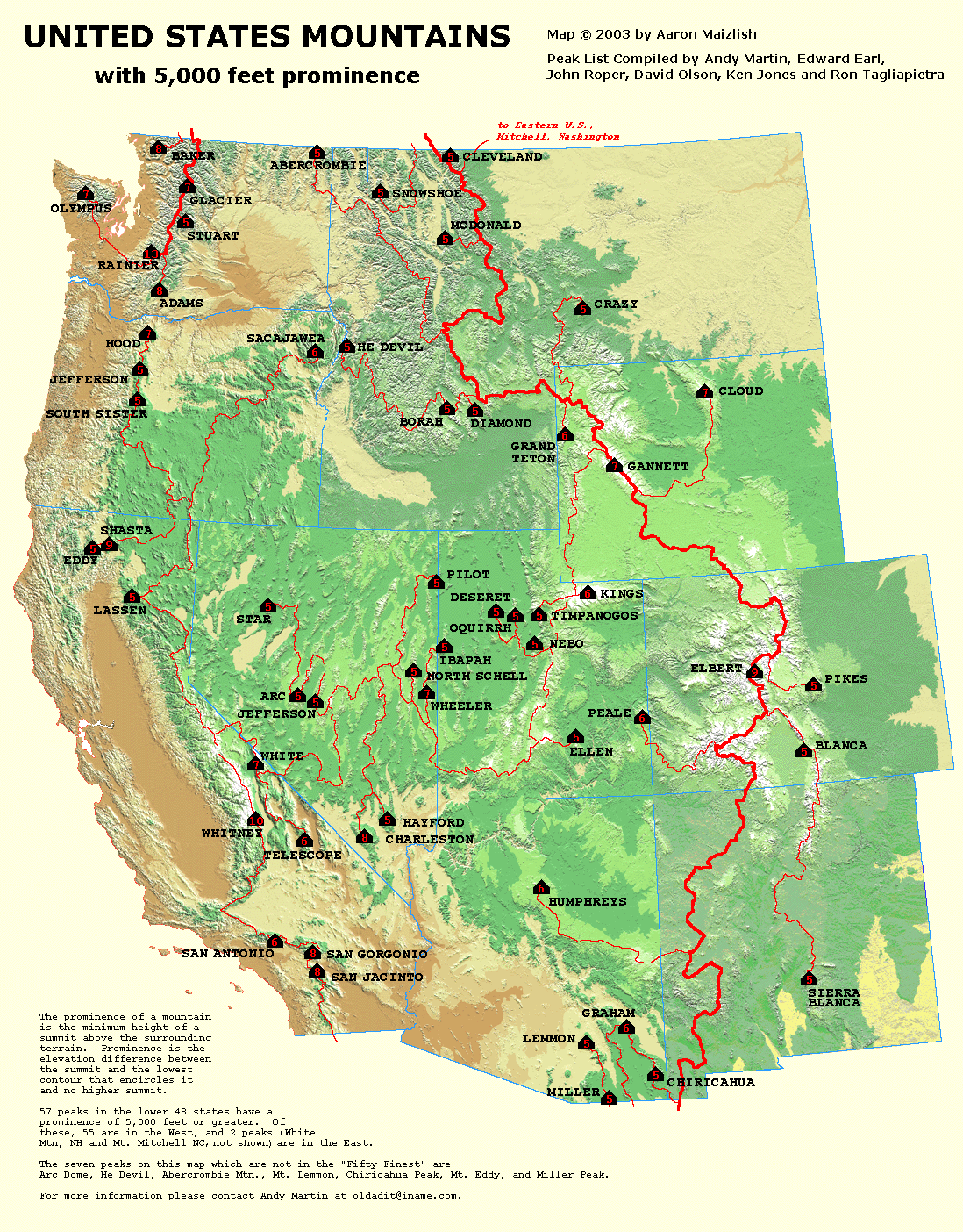
Star Peak, at 9836 ft (2998 m), is the tallest peak in this view. It's the pointy one on the left. Star Peak is one of the 57 peaks in the lower 48 with 5000 feet or more of prominence (prominence explained here with a map of peaks in the west), and it ranks #6 in prominence in Nevada. The round "hill" in the center is 8940 ft, and the seemingly lower hill a little right of center, which is a bit farther in the distance, is an unnamed peak at 9031 ft.

Monday, May 26, 2014

The Middle Adit at Majuba Hill

Our goal on Majuba Hill, while driving up the switchback road past the Keep Out sign, was the Middle adit, which is known by some to be the main entrance to mineral collection sites within the mine.
Here we are, ("we" being a very small portion of the ±80-person-strong field trip) standing around the flat area in front of the Middle adit.
A closer view of the mouth of the Middle adit, overhung by talus, and with old rails heading into the old workings.
There's a nice bit of tourmaline breccia just inside the mouth on the right, but it didn't look like a great place to be hammering, and the breccia wasn't very photogenic.
The entrance to the adit is barricaded and posted, not sure by whom.
I stuck my camera lens inside the metal grating and took a natural light photo. The old rails emerge from a rockfall area and continue into the dark distance.
Another photo, taken with the flash, gets us a tiny bit farther into the mine.
I suspect that had the entrance been open, a few geologists with headlamps (and secondary backup lights) would have ventured in!