Tuesday, July 11, 2017
High Water Across the West: The Truckee River
The first photo was taken at a scenic overlook near Patrick along I-80, looking to the southeast. The river is high between us and the dark brown mass of intrusive dacite that forms a synform known as Giant's Throne (you can read a little about this feature here or purchase the field guide here).
Here (above), from the same location, I zoomed in on the river just south of I-80. The trees were just getting their spring leaves and were bright yellowish green.
After a bit, I pulled off at the westernmost Fernley exit and drove south into Wadsworth, a small town along old highway 40 (which is not signed 40 anywhere in Nevada, afaik). These photos, above and below, were taken at a bridge over the Truckee in the eastern part of Wadsworth.
I zoomed in on the water roiling downstream from a cottonwood tree sitting farther out in the water than usual.
I couldn't resist a photo of this old church. Once upon a time, while in high school or early college, I painted a watercolor of a similar church located back east in northern Virginia. I'm still fascinated by the style — not sure why.
Unlike some other rivers in the west, the Truckee was nowhere near impacting the old highway 40 bridge from below.
The railroad bridge spans the Truckee less than 50 meters away from the highway bridge.
For some reason, this view looking downstream reminded me of swamps in southeast. Maybe it's just the way the trees were sitting out in the river.
While down on the river between the two bridges, I grabbed one more shot of trees out in the river. And after standing there for a few minutes, I remembered I had to get back on the freeway. 😢
All photos were taken on 14May2017. The river is still high.
Tuesday, June 20, 2017
High Water Across the West: Rye Patch Dam and the Humboldt Sink
![]() |
| Rye Patch Dam on April 19th. The water in Rye Patch Reservoir is high, but not at the high water mark that can be seen just past the spillway. |
![]() |
| Rye Patch Reservoir and Majuba Hill. |
![]() |
| The same view in June, 2016, from Google Earth. |
![]() |
| A few Western Grebes swim in the shallows. |
![]() |
| A closer view of one grebe. |
![]() |
| I couldn't resist this view of the Humboldt Range. |
![]() |
| Snow-capped Star Peak hides behind clouds. The Cordex Pit of the Florida Canyon Mine operations might be barely visible below Star Peak. |
![]() |
| The Humboldt Sink had water in it! |
![]() |
| A closer view of the Humboldt Sink and the West Humboldt Range. |
Tuesday, May 30, 2017
High Water Across the West: The Humboldt River at Winnemucca and Humboldt Station
The flooding in Winnemucca was really quite extensive when I drove through on April 11th (no photos) and then again on the 19th: several backyards and a few basements or first floors of houses near the defunct "Barrick Arms Apartments" were under water. The water had receded incompletely when I saw it last (May 28th).
These first pics show the Humboldt River's floodplain looking more like a marshy lake than it's usual dry self. Water level was slightly lower on April 19th than when I first saw it on the 11th.
Here's a phone-camera panorama, with Blue Mountain way off on the left and Winnemucca Mountain taking up the right half of the photo.
And just because, I've included a picture centered on Winnemucca Mountain. It's a prominent feature and a landmark for miles and miles. If you look closely, you'll see the two-toned "W" painted on its southeastern slope.
On that same day (the 19th), I pulled off I-80 at Humboldt House (exit 138, marked "Humboldt") and drove old Highway 40 back toward Imlay.
I crudely spliced together two or three photos looking northwest across what I thought was Rye Patch Reservoir.
It turns out that the entirety of the water seen in these photos is contained within the Upper and Lower Pitt-Taylor Reservoirs.
Here we see Majuba Hill behind blue water in the Lower Pitt-Taylor Reservoir. The light beige horizontal line between the water and Majuba are bluffs underlain by Lake Lahontan's Sehoo Formation. A narrow part of Rye Patch Reservoir proper runs between us and those bluffs, but we can't really see it, even though the water is running high.
Here we can see both the Lower and Upper Pitt-Taylor Reservoirs. The Lower is closest to us; the Upper is beyond the horizontal pale beige line separating the two bodies of water. The wide upper part of Rye Patch Reservoir lies not far beyond the Upper Pitt-Taylor, hidden from us by some irregular low hills. Off in the distance, we're looking at pointed, snow-covered King Lear Peak, part of the Jackson Mountains. The 8923-foot-high peak (2720 m) is about 45 miles away.
Tuesday, May 16, 2017
High Water Across the West: Honey Lake
The lake is beyond full for what has been typical for several years, with bushes drowned around the edges and fences under water. In fact, you can see a bit of a fence or gate in the picture above, near shore, a little right of center. Most of the fenceline is completely under water.
Here's a relatively broad view of the lake taken on April 25th.
I cropped the previous photo so it would closely match the first photo from the 11th.
And this photo matches the second photo from the 11th. If you look closely at the two matching sets, you can see that the water was slightly higher on the 11th, and had gone down a teensy bit by the 25th.
I have several years of pictures of Honey Lake: there are these comparison photos from 2007 through 2011, these few photos from May and June of 2015, and one photo from early March, 2016. Even more photos can be found by searching the blog for "honey" (along with a few from nearby Pyramid Lake). Most of my photos through the years have been taken from the Honey Lake Rest Area).
Sunday, January 3, 2010
The Caliente Series & Caliente Camp Series
The Caliente Camp series: These posts are mostly about a helicopter exploration camp I was part of in 1978, with some accounting of the two 2009 road trips I took to the area to travel down old roads. These stories - Map area in Meadow Valley Wash: about the first area I mapped as a professional geologist, with some geological references.
- Our Camp in Meadow Valley Wash: a little about the first Caliente trip and the 2005 Meadow Valley Wash flood, an introduction to the 1978 helicopter camps in general, and an introduction to the Caliente helicopter camp in particular: camp basics, camp equipment, recon basics.
- Caliente Camp: Some more Exploration: my second visit in 2009 to re-check the old campsite, along with the checking of a couple other nearby areas, looking down the railroad tracks and bridge near the old camp, and photo shots of sand, running water, underbrush, cliffs, and wildlife.
- Caliente Camp Continued: Part 3: camp layout, camp construction, the water and shower system, the helicopter and buzzing of the outhouse or shower.
- Caliente Camp Continued: Part 4: I get unwanted attention from the camp cook and helicopter fuel-truck driver.
- Caliente Camp Continued: Part 5: what the food was like, more about the two camp cooks, and who will be in which camp.
- Caliente Camp: Part 6: A bit of a truck problem in Kane Springs Wash while the helicopter is down for maintenance.
- Caliente Camp Part 7: Getting Stuck in Pennsylvania Canyon: We drive into the canyon while doing truck-assisted exploration - and can't get out!
- Caliente Camp Part 8: Getting out of Pennsylvania Canyon: We get unstuck, and escape!
The Caliente series: These posts are mostly about my 2009 road trips to the Caliente area, although part of the two trips are documented in the Caliente Camp series, and some 1978 stories are told in at least one of the Caliente series posts. The Caliente series includes a couple posts about the geology and rock formations of the area, and other related items like the wildfires that were in progress during my second field trip. These stories - From the Field: Caliente, Nevada: about Caliente, Nevada, the railroad station, a weather station, and smoke from California fires.
- Caliente Smoke Update: the thick smoke in the Caliente area was from the large Station Fire in southern California.
- International Vulture Awareness Day, 2009: photos of a turkey vulture seen near Caliente.
- Smoke from CA Fires as Seen from the Ella Mountain Lookout: photos taken from the Ella Mountain Lookout in the morning and afternoon, the geography of the area, the lookout, and a little bit about getting to the lookout.
- Meadow Valley Wash: Cottonwood Canyon to Elgin: about the Cottonwood Canyon area, about a couple 1978 traverses we did in the area, and pictures of volcanic rocks in the cliff walls of Meadow Valley Wash south of Elgin.
- Meadow Valley Wash: Elgin to the Narrows: driving from Elgin to "the Narrows," the Elgin schoolhouse, a "damaged" dirt road not taken (introduction to Pennsylvania Canyon), "road closed" and "flash flood area" signs, and the south end of the Rainbow Canyon part of Meadow Valley Wash.
- Friday Field Photos: The Narrows: what rock is this? There were no correct guesses
- Meadow Valley Wash: The Narrows: the spectacular ash-flow tuff cliffs at "the Narrows," a deer, and the creek in Meadow Valley Wash, with some geological references.
- Friday Field Photos: Tepee Rocks: the ash-flow tuff making up the rock formation known as Tepee Rocks east of Caliente on the road to Ella Mountain Lookout (whew!), with some geological references.
- Meadow Valley Wash: Up the Canyon to Caliente: driving from "the Narrows" to Caliente, looking for the side road to the 1978 map area of the Caliente Camp series, train tracks and a train, and a beer at the end of the road.
- Pennsylvania Canyon: Getting There: driving the dirt road to the Ella Mountain Lookout, bad roads, on the wrong road, some unusual trees (Gambel oaks), and I'm about to go into Pennsylvania Canyon.
- Pennsylvania Canyon: Into the Canyon: driving into Pennsylvania Canyon over steep, rocky, and sandy roads; a wild horse or four or five; a washout or two; a lunch; and more unusual trees (Ponderosa pines).
- Caliente Camp Part 7: Getting Stuck in Pennsylvania Canyon: How we got stuck in the sand in 1978.
- Caliente Camp Part 8: Getting Out of Pennsylvania Canyon Yes! We did get out!
Last update on 15Oct2012
Friday, December 12, 2008
Friday Field Photo #4
Gateway to Northumberland Canyon; photo looking east.
The entrance to Northumberland Canyon, coming in from Big Smoky Valley in central Nevada, is marked by a sentinel of Northumberland Tuff overlooking a dry wash that was in high flash-flood conditions on August 7, 1979, while I was doing field work in the area.Well, that's a great lead in, but what I really wanted to do was post a field photo before Friday was completely over, and it looks like I've just barely made it. I took the photo a couple weeks ago while out driving around.
The cliff of strongly welded Tertiary ash-flow tuff looks like it may be capped by some black chert, and that would be Ordovician Vinini Formation chert on top of Tertiary ash-flow tuff. If that's what it is, it's pieces of chert and slide blocks the size of trucks, and larger, that slid into the caldera, forming an intracaldera breccia and slide-block formation that we called Unit 1, way back when.
A bit more on that later.
Sunday, September 21, 2008
Summit Lake and Beyond: AK2008 Day 2
...so we went on in, found a place, and sat down. Summit Lake Lodge has good food, good beer, a good atmosphere, and a good view.
Sometimes it's worth stopping at the gift shop at the south end of the parking lot - to get milkshakes, espresso, T-shirts, or other gift-type items.
After lunch, we headed south on Alaska Route 1 to Tern Lake, where the Seward Highway continues south to Seward as Route 9, and the Sterling Highway continues west towards Sterling, Soldotna, Kenai, and Homer as Route 1. Tern Lake is a great place to stop to see wildlife, to stretch your legs, and to get a good view of more mountains and another great U-shaped glacial valley, seen above looking southeast towards Moose Pass.
As you drive away from Tern Lake, to the west and back toward the Sterling Highway, you'll have ample opportunities to stop and examine several metagrawacke roadcuts like the one above, which is cut by a network of quartz veins. In fact, you can't miss seeing the slaty graywacke, even if you don't stop at Tern Lake - there are several good collecting places here and there near the triangular junction of the Sterling and Seward highways.
Suddenly, the parental driver (my dad) took a sharp left turn, and we headed into the woods toward the Tern Lake campground.
A short walk from a little pullout on the dirt road before the camp will take you to Dave's Creek, a good place to view spawned out red salmon.
The red salmon, or sockeyes, are still hanging around, some going barely going upstream, most barely holding their own against the current.
Above, the photo looks back toward Tern Lake at the head of Dave's Creek. Downstream and to the west, Dave's Creek joins Quartz Creek and empties into Kenai Lake near Cooper Landing. It's amazing: all these lakes have creeks and rivers going into them and out of them, and all of them eventually empty into the ocean! (Well, maybe I've been in the Great Basin too long - actually thinking that lakes and oceanward drainage are amazing.)
The road goes on, pointing more-or-less toward Redoubt Volcano, which can't be seen through the clouds on this particular day.
Finally, then, we found the right turn-off from the Sterling Highway, and we made our way on pavement and the dirt to the cabin - seen above in an earlier rendition before it was lifted off the ground after the September 1995 flood, which occurred not long after the painting of this strange picture.Tuesday, July 29, 2008
Flash Flood on Highway 50
As MOH and I were driving over Mt. Airy Summit west of Austin the other day, our first clue that thunderstorms had caused a little flash flooding was the brown, muddy, knocked over bushes on the side of the road.
Our second clue was - lo and behold, some actual mud and wet ground - in Nevada!
Our third clue was that someone had recently been pushing some dirt around, as though the water and sediment had actually flowed across the road.
Ah, and who's been moving the dirt? Yes, there was a little construction activity in progress as we drove slowly through!
Mt. Airy Summit is a broad, almost unnoticeable summit about 15 miles west of Austin, and all the flooding activity had seemingly taken place on the east side of the summit. It didn't look like there was a whole lot of drainage area upstream from the flash-flooded dry washes - some washes on the north side of the highway and some small drainages right along the road.
Mt. Airy Mesa, the hill shown in the photo above, is formed of columnar-jointed ash-flow tuff sitting on some white to light greenish-yellow poorly welded tuff or lake deposits, the latter of which are strongly clayey.
These rocks units are denoted as Tt2 and Ts2 on the Geologic Map of the North-Central Nevada, which are designated as being in the 34 to 17 Ma range. The large square in the map above is a township, about six miles on each side. [Note: this map shows Highway 50 going through Railroad Pass to the south on the road now known as Nevada S.R. 722, formerly known as Route 2, and before that known as Highway 50.]
The drainage area for the flooding seemed small to me, and possibly the clay in the Ts2 unit contributed to runoff. The thunderstorm must have dumped a lot of water really fast in the highlands at least on the north side of the highway, and possibly on the south side. [Note: "dumped", "a lot", and "really fast" are technical terms - well, I mean, I wasn't there when it was raining, and can't find a single thing written about this little flash flood that must have taken place on July 24th.]
If you're working in an area, you can examine flash-flood cuts and deposits like this one when they are fresh. In a year, come back and look again: the dry wash will look much the same, but the bushes will be in better condition. If you come back year after year, you can gradually get an idea of what a dry wash looks like after a certain time has passed, and you will be able to estimate the date of the last flash flood by looking at any dry wash anywhere.
The fact that a particular dry wash flooded within the last year, or hasn't flooded for ten years - using the above estimating method - doesn't really say anything about whether the dry wash is ripe to flood again anytime soon, so don't use that estimate as a guide to whether you are safe from being caught in a flash flood. Some drainages seem a little more prone to flash flooding, and some types of drainage areas are more dangerous to be in during a rainstorm.
It would have been fairly easy to get above the flash-flood at Mt. Airy Summit because very few of the dry washes overflowed their regular stream banks; when they did, the water wasn't very deep - judging from the muddy watermark on the sagebrush maybe a foot or two at most. However, there would have been no way of knowing at the time how long the rain would fall or what size the flash flood would be. So it's a good idea to get to high ground when rain is pouring all around you or when it's falling upstream. Flash floods can run for miles and can carry large boulders or even pickup trucks with them.
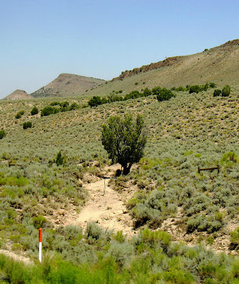
We saw only minimal evidence for other flash flooding between Austin and Fallon, Nevada - above, a little flash flooding had been going on on the west side of Sand Springs Pass, about 25 miles east of Fallon. Location of the photo is near Bench Mark 4372 in the lower left (southwest) part of the linked-to MSRMaps map.
I've only been near one stream when it was in flash-flood mode. Water was roaring down the little stream on the west side of the Virginia Range south of Reno, Nevada. It never rose high enough to overflow the banks, but the sound of boulders smashing against one another was impressive.


