I'm doing the year-end meme wherein I compile the first sentence of the first post of every month. Meme rules are as follows, as per DrugMonkey:
Post the link and first sentence from the first blog entry for each month of the past year.
I also add the first photo from the same first post. Previous takes on this Twelve Month meme at LFD were posted for 2008, 2009, 2010, 2012, 2014, and 2015.
After checking out the southern route to Mineral Ridge while on my 1976 thesis quest, I headed north out of Silver Peak on then Highway 47 (now S.R. 265), carefully measuring the miles to the left-hand turnoff.
From the vantage point of the end of the last post, a little southwest of Luning, Nevada, I turned around and pointed my camera northeast across Soda Spring Valley ... and paused to think back to the late 1980s, when we in the Western District of Former Mining Company had finally taken over exploration of the Walker Lane, which until then had been a mostly unexplored part of the Nevada District.
May:
I'm not sure how I got started on checking different words and concepts on Google Books Ngram Viewer yesterday, although my "History" tab suggests to me that it might have been related to some reading I was doing on science fiction.
I collected this hand sample from the Original Bullfrog mine, Nye County, Nevada, sometime back in the mid to late 1980s when doing recon in the area, then cut and polished it—probably with a company saw and grinding wheel.
We're now about two thirds of the way up the hill toward Red Pass on the Titus Canyon road, a one-way road that runs approximately east to west from Nevada into California, starting not far south of the ghost town of Rhyolite.
There I was, preparing a few photos for posting in the ongoing Death Valley Trip – Titus Canyon series, doing my usual thing of marking up photos in MS Paint (I'm too cheap to buy any real photo programs), when I figured that I must have something around the house that might work better than either dragging the cursor across the screen with my trackpad or dragging my finger across the computer's touch screen.
Now we'll leave the parking area near the Leadfield sign and, as I promised last time, we’ll walk out to what I’ve been referring to as the “far west cabin," although maybe that should really be "far northwest cabin."
When I drove to the area on the south side of the Whipple Mountains where I ended up camping amidst downpours and nearby lightning, I thought I'd grab a few photos of the Colorado River Aqueduct, which passes through just north of CA Highway 62 on its way to the greater L.A. area, but an RVer was camped just beyond the aqueduct overpass, so I blew it off until I left.
I collected this hand sample from the Original Bullfrog mine, Nye County, Nevada, sometime back in the mid to late 1980s when doing recon in the area, then cut and polished it—probably with a company saw and grinding wheel. This specimen is no doubt the best one I still have (a few may have been lost during one or two house moves), although it's been a while since I looked through all my rock boxes. This one photo has already been featured in two earlier posts, here and here.
I've got a few more photos to show you. These zoom in so we can see the size of the shiny ore minerals contained within the rock: v.g. (visible gold) and a silvery-gray silver mineral.
Here's the other side of this same rock.
We'll be focusing in on the lower left.
I've zoomed in here. Can you see the shiny flecks?
Well, it's hard to see them without holding the rock up to the light and waving it back and forth to get the metallic glint, so I've circled the little bits in yellow and light blue (cyan). Yellow is for gold; cyan is for silver.
See them now?
Yes, these are very tiny flecks of native gold and a silver mineral. The silver mineral is probably either acanthite; Ag-bearing tetrahedrite, with Ag substituting for Cu in the solid-solution series with freibergite; or uytenbogaardtite.
Zooming in even farther, we can see the ore minerals without enlarging the photo.
A few of these show up really well.
Next time I get my hands on this sample—I think it's still up in Alaska—I'll see if I can get even better photos.
We're officially on the Titus Canyon leg of our larger Death Valley trip—a round trip odyssey that will take us to and near a number of places. This section of our journey began with the last post, which was centered around Beatty. I’ll be complementing my February photographs with photos from a similar journey MOH and I took back in the late spring of 2009. So, let's get on with it! We'll begin by leaving Beatty.
There are two ways to get to the Titus Canyon road from Beatty. I usually forget that fact because it's generally been years between journeys into the canyon. Consequently, I seem to end up on this route one time, and that route the next time, alternating routes without really thinking about it. Then I wonder why the road, the signs, and the overall lay of the land don't look the same as the last time I passed through the area.
Beatty's main intersection: a 4-way stop.
We went one way in 2009, turning left at Beatty’s main intersection, which kept us on U.S. 95 as we drove east and then south through and out of town. We passed the dirt turnoff to Fluorspar Canyon (might there be some fluorite up there?) and passed into the Amargosa Narrows. Not far beyond the Narrows, we turned right onto the unsigned paved road to the Beatty Airport, which goes by an obscure ghost town, Gold Center. Airport Road turns to dirt beyond the airport.
The Amargosa Narrows: Precambrian Z rocks crop out on the right, left, and straight ahead.
We went the other way this past February, going straight on Nevada S.R. 374, the Daylight Pass road, at the same intersection. This paved road winds through a bit of the Bullfrog Hills, going by Velvet Peak and Paradise Mountain. It then meets up with Airport Road near the Bullfrog pit of the currently inactive Bullfrog open pit gold mine.
The Bullfrog pit, as seen from the dirt portion of Airport Road, looking across a sea of blooming creosote (from the early May trip, 2009).
The Bullfrog gold mine—AKA the Barrick Bullfrog gold mine—was in operation from 1988 or '89 through 1998, when it produced about 2.4 million ounces of gold from two main open pits, the Bullfrog pit and the Montgomery-Shoshone pit, and from at least one related underground project, the North Extension. Discovery of these ore deposits began in 1982 with St. Joe Minerals Corporation (overall history is described in some detail here, here, and here). The exploration property then passed through several companies in quick succession through a series of acquisitions or buyouts, going from St. Joe to Bond Gold Corporation, then to Lac Minerals Ltd (or LAC Minerals Ltd, depending on the year—this company went back and forth with its name several times in a few years), and then to Barrick Gold Corporation.
The deposit is hosted in Tertiary volcanic rocks, mostly ash-flow tuffs that are cited by Castor et al (1989) as being correlative with the Miocene Timber Mountain Tuff, which has age dates ranging from about 10 to about 15 Ma (Geolex). In fact, the host formation was mapped by Maldonado et al (1990) as the Rainier Mesa Member of the Timber Mountain Tuff.
I had a tour of the Bullfrog pit back in the late 1980s or in 1990, while I was working for Former Mining Company. Bond Gold was probably the operator when I was there, and the mine was just called the Bullfrog mine. We learned then that much of the overall low-grade ore is concentrated in veins, breccias, and stockworks, and we thought at the time the deposit would be fairly difficult to make money at. It later surprised me that a large company like Barrick got involved in the mining. (I have no idea how the economics really played out; so much can depend on the up front expenditures a company has made and the price of gold during production.)
The deposit formed near the end of an extreme extensional event that took place in the area between 11.4 and 7.6 Ma (Castor and Weiss, 1992; Weiss et al, 1995; Castor et al, 1999). Although ore is partly hosted in and controlled by structures in the upper plate of the Bullfrog Hills detachment fault, it's not generally considered to be a detachment-related type of ore deposit (although knowledge of detachment faulting and related structural models would be indespensible for making discoveries in the Bullfrog mining district).
A little farther down the Daylight Pass Road, about six miles from the center of Beatty, the Titus Canyon dirt road heads WSW toward the Grapevine Mountains.
Turnoff to the Titus Canyon road.
The Titus Canyon road is a dirt road of variable character, narrow and washboardy in many parts, and entirely one way east to west. It isn't possible to turn around once you get going, and from asphalt to about "Tan Mountain," [name from Panoramio photo no longer available] there are few pullouts. It's possible that one could exit the road in two or more places within this first section, but it's not clear to me that any of these possible exits are really roads.
High clearance 4x4 vehicles are recommended!
Although 4WD is not usually necessary along most sections of the road, high clearance is a must, and 4WD can become necessary at any time (especially during bad weather). I think the road is blocked from the east when bad T-storms or flash flooding are expected, but I'd always want to check the weather to avoid getting stranded during a bad washout, like the kind the Death Valley area experienced in October, 2015.
This is what the October flooding looked like, during and after:
Don't get caught up in one of these!
Somewhere between the Titus Canyon warning sign and the Death Valley sign, you can look off to the north and see some classic Nevada ash-flow tuff formations, in this case tilted moderately along two detachment faults. The visible roads and workings are in the area of the Original Bullfrog mine, a little less than four miles west, as the crow flies, from the Bullfrog open pit.
Tilted volcanic rocks on Bullfrog Mountain (the highest point in the photo), with the Original Bullfrog mine not far left of center.
Wildflowers and creosote are in bloom in this May, 2009 photo. More precise photo and location information can be had by perusing the map near the end of this post.
I got to fooling around, saving this Google Earth image of Bullfrog Mountain from a similar angle as my photo above.
The same Google Earth image with two kmz file overlays.
What fun! Okay, this was so much fun, I went ahead and made the image match my photo more precisely, and then added a few geologic labels.
The photo, again, for comparison with the image below.
Geologic overlay of Google Earth (G.E.) image, labeled.
This is a good part of the Bullfrog Hills in which to see the results of the extreme extension that occurred in the area during the Miocene, although I'm not sure if its possible to actually place a finger on the main (or secondary) detachment surface. For the most part, the detachment faults are shown on the maps as dashed beneath Quaternary cover. In only three areas is either detachment fault mapped in the hills where we might be able to go look at the fault planes, and in only two places are dip measurement shown, and both sites are in the low hills to the east of the photo and images.
As for the rest of the local geology, the mylonitized lower plate Precambrian rocks are easily reconnoitered in the light colored hill on the far left of my photo (lower left of the G.E. geologic image), and the tilted volcanic section is easily walked in the hills above the Original Bullfrog mine. The main volcanic formations, oldest to youngest (west to east, left to right), are as follows: Ts3, mostly sandstone, shale, and conglomerate; Tql, quartz latite lava flows; Tlr, the Lithic Ridge Tuff; Tbt2, bedded tuff; Tcb, the Bullfrog Member of the Crater Flat Tuff; Tbt3, bedded tuff; Tpc, the Tiva Canyon Member of the Paintbrush Tuff; Tbt4, bedded tuff; and Tmr, the Rainier Mesa Member of the Timber Mountain Tuff. The Op on these maps is the Ordovician Pogonip Group, here consisting of limestone only 60m thick. The Zm consists of Late Proterozoic metamorphic rocks that have mid- to late Miocene cooling ages related to the regional extension.
Bullfrog ore.
The lower trenches at the Original Bullfrog mine used to be a great place to stop when driving through the area. (The location dot in the last image shows the site of the original mine, not the lower trenches; the lower trenches are more easily seen in the last photo as the small color anomaly below the location of that dot.) The easily unearthed quartz-amethyst veins contain v.g. and other neat minerals (see this post and next week's post). Much of the mineralized material was mined out in the 1980s (or earlier?), and a bunch of it was placed on a nearby heap leach pad. I doubt that leaching was an efficient way of recovering gold and silver from this ore, and we used to bemoan the placing of all this great specimen material out to leach. Not long after my first introduction to the area, which was probably in about 1986 or a little later, someone—no, I really can't won't say who—came and scraped the leach pad, removing all the rock in order to recover and melt the gold and electrum down for a wedding ring (at least that's the story I've heard). I visited the area most recently on the last day of the last millennium (depending on when we say the millenium started). I camped on one of the drill roads after wandering around the roads, trenches, and prospects. I didn't find much. If you ever happen to stop by the area, remember that you're probably on patented (private) ground, at least up near the original mine site, although I don't remember seeing any signs.
The Death Valley National Park boundary on the Titus Canyon is marked by signs, a fence, and a cattle guard.
Here's where we'll stop our journey today, right at the eastern boundary of Death Valley National Park (as an oldtimer, I keep wanting to call it a National Monument).
On this leg, we will finally make it into Beatty! Yay!!
In our last episode we were at Black Rock (it should be Black Rock Point, or something, but isn't) checking out Lone Mountain and the Boss Mine. Before leaving, I managed—with my handy-dandy, relatively new Nikon DSLR with 18-300 mm zoom—to get this shot of the far-away Crescent Dunessolar thermal power plant, which reportedly went online in February.
The power tower and mirrors of Crescent Dune in front of the San Antonio Mountains. Part of the defunct Hall moly mine can be seen on the far left. The tower is about 18.5 miles distant in this photo.
And then we got back in the Jeep and proceeded down the road toward Tonopah, where we had some coffee and a snack, and went on our way—again.
As we drifted south from Tonopah, side roads tried to distract us from our goal of reaching Beatty that night. So much to see! So many possibilities! We resisted being drawn astray (resistance is sometimes but not always futile), but upon spotting the first batch of Joshua trees just north of Goldfied, we gave in and pulled over to take a look.
It turns out that we pulled over only to take photos of a tree I had photographed in 2010 and posted about here.
Several views of my favorite Joshua tree:
Relatively close view of the large-ish Joshua tree we stopped for.
This particular tree is not far from Highway 95 and is just a skip and a jump down the Silver Peak Road. It might, therefore, be one of the more photographed Joshua trees in Nevada. Here it is on Google Street View.
A closer view.
We were unclear about a few non-branching types of yucca (next two photos), but I think this is probably a young Joshua tree.
A closer view of the leaves of the non-branched tree.
The entirety of the Joshua tree from the first two photos. Lone Mountain is on the left (NW); the hill going into Tonopah is over there on the right (N).
I just noticed the snow-capped range beyond Hasbrouk Peak and the other hills near Tonopah. This is the high part of the Toiyabe Range, including Toiyabe Dome (11,361 ft, 3463 m) and possibly Arc Dome (11,773 ft, 3588 m), which is the highest point in the Toiyabes.
There was a weak to moderate desert pavement across the area, and we hunted around for ventifacts. Not sure if these two rocks qualify, but they do show typical varnish:
The varnished rocks are probably probably volcanic.
More Joshua trees against the backdrop of the volcanic mesas to the west.
We got back on U.S. 95 and headed south, passing through Goldfield, and pulling off the highway just one more time just north of Lida Junction. I looked down a dirt road I'll probably never travel, a road leading mostly into the unexplored Nellis area.
Stonewall Mountain is partly in and partly outside Nellis, so it's possible I'll get up to the west side someday, to look at those brightly colored volcanic rocks.
Sunlit alluvial fan rills, shadows on the colorful mountains, and Joshua trees.
We were ensconced in our Beatty motel room by 4:45 pm. We didn't waste any time before going out to find some food.
The rock itself was on an alluvial fan not far from Walker Lake; it was pointed out to me by MOH, who spotted it on our second-day hike to some Pleistocene shorelines. Although it was lying on a grusy soil amidst large granitic boulders, the rock looks porphyritic. I don't know if it's a porphyritic version of the granitic intrusive rock lying around, or if it's extrusive in origin.
Just north of Silver Peak on S.R. 265 and just downhill from Mineral Ridge, one of Nevada's most accessible basaltic cinder cones rises out of the low alluvial slopes. The photo, taken from the northeast side of Mineral Ridge, where we made our last stop, shows the basalt cinder cone known as "The Crater" sitting in front of a southern bit of the Weepah Hills, the more distant and linear Paymaster Ridge, and the Clayton Valley playa, with its pale turquoise lithium brine fields.
A Google Earth view of The Crater and associated basalt flow rock.
The cinder cone is assymetrical, as are many, with a breached east-facing side, where basalt lava flows erupted and spread downslope toward the Clayton Valley playa.
The cone is right beside S.R. 265, just north of Milepost 4, between Silver Peak and Blair Junction (see the map below).
Access to the cone includes a two-track dirt road on the south side and a pullout on the northwest side.
Click to enlarge this location map, the spliced and labeled Tonopah and Silver Peak 30x60 sheets, courtesy USGS.
I pulled into a flat area on the northwest side of the cinder cone and walked around a little bit, stopping briefly while on my way to elsewhere: In 2010, I was on a loop from Tonopah to the Klondyke mining district to Silver Peak and Mineral Ridge and then back to Tonopah; in 1976, I was leaving Mineral Ridge to go to my next stop in California. Both trips took me past the cinder cone; both trips resulted in my next immediate destination being Blair Junction.
The Crater, looking southeast from its northwestern flank.
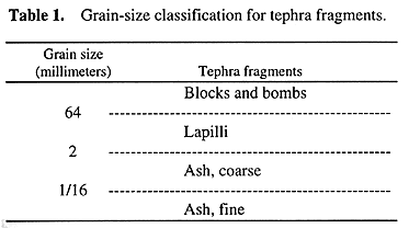
The cinder cone—at least the small chunk I saw—is composed dominantly of basalt blocks and bombs and smaller, lapilli-sized fragments.
A basic grain-size classification scheme for tephra, pyroclastic fragments that were thrown out of volcanoes, courtesy USGS.
Almost all the info on the web about this extinctvolcano is contained in this one article by the Nevada Bureau of Mines and Geology (NBMG). The most detailed geologic map of the cone and area is here, in Figure 3B, along with a good description of the cone on page 9. This latter citation (Hulen, 2008) has the best reference to the only age date I could find:
“...the basalt has been K/Ar-dated at ~400,000 years (J. Witter, pers. comm., 2008), but this age is at odds with the cone’s barely-disturbed morphology. Accordingly, Witter has submitted a sample of basalt flow rock, clearly sourced from the cinder-cone vent (Figure 3B) for more reliable 40Ar/39Ar age-dating.”
All the other references I found state that the cone is about 390,000 years old without providing credit to an original source.
After parking and getting out of the truck, I walked around for a little while, trying to find some good examples of volcanic bombs. Rather than collecting any hand samples, I took a few photos.
Vesicular basalt.
This hand specimen from The Crater doesn’t show any indications that it was molten or semi-molten when it was thrown out of the vent or when it landed on the cone’s slopes—it is therefore considered a block and not a bomb—but it does show the average character of the basalt: dark-colored and with lots of small to medium-sized vesicles. The basalt is reported to contain phenocrysts of feldspar, hornblende, pyroxene, olivine, and magnetite (Price and Price, no date). I readily identified the small, light greenish olivine crystals in the basalt, though I didn’t get any pictures of the phenocrysts.
Volcanic bomb with a ropy or fluted texture.
The bomb is elongate in shape, and one end is wider than the other. Possibly the narrow end was upward when the bomb fell, still viscous, through the sky.
This could be a bit of flow or cooling texture in a basalt lapilli, but I'm not sure.
A large block of basalt with ropy and vesicular texture.
Am I seeing some aerodynamic shaping in this block, and perhaps some slight breadcrusting? Is this a bomb?
And here's a closer shot.
Here's a bomb with fluted texture, approaching spindly.
I probably should have looked harder for better examples of bombs, and maybe next time I visit, I’ll get around to the far side of the cone—or even up to the top!
A spiny bush and a prickly pear cactus growing on a desert pavement of basalt lapilli, small blocks, and bombs.
The bush looks like some kind of Atriplex or generic "saltbush," but I'm not sure which kind. Any ideas?
We can see the Weepah Hills and bluish Lone Mountain off to the northeast, beyond the dark, lower slopes of The Crater.
Next in this series, we'll head over to California.