Showing posts with label lake. Show all posts

Monday, January 9, 2023

Update from the Lake: Wintry Days

During the recent holidays, I was fortunate enough to spend a few days at my favorite northern CA lake. I was unfortunate enough to be "mildly" ill during that time, recovering from an unknown malady that caused upper and lower respiratory distress, inflammation, infection—whatever—something that the local clinic (in my northern NV home area) did not bother to test for, but gave me two anti-inflammatory medicines, Z-pak and prednisone (Z-pak is primarily an anti-biotic, but who knows if I needed one).
While recovering, mostly by relaxing in front of a wood cook stove, I took a few walks down to the local beach area, where spring water enters the lake.
So, let's go for a walk or two.
Christmas day, it was sunny but occasionally foggy.
The lake has a little picnic area, though it was a little cold for just sitting around.
Nice lake view, looking south toward the dam, which is not in view.
A few days later, I made another hike down to the lake. It was a gray, cloudy day. A bright white line on the shore across the lake stood out, creating a little bit of lighting drama.
Down on the rocky shore, water from a spring feeds into the lake, causing a bit of green—probably algae.
A few old stumps from when trees were cut before the reservoir was filled, back in 1914, are scattered about. Most of the present-day lake bottom consisted of meadow and marshland before filling, so tree stumps exist only along some shores.
The last photo looks west, down the rocky shoreline. Rocks consist primarily of rounded and partly rounded basalt cobbles and boulders, derived from the dominant bedrock of the area: basalt not far below the soil of the surrounding forest. Snow line here is below the high water mark, which is probably about 5 feet below the lowest pine tree, just below the upper concrete slab (concrete?). That is, when the lake is full, you can walk along the shore by moving from boulder to boulder, to do a little fishing (although technically, any land above the high water mark outside the beach area is private land).

Sunday, June 6, 2021

Washoe Lake, Slide, Mt. Rose, and Lake Tahoe

Just a quick shot taken from a plane a couple days ago, looking south from around 12,000 feet or so. We circled Lake Tahoe completely, finally coming into the Reno airport from the south—an approach I'm not sure I've been on in my several decades living in the area.

Wednesday, October 24, 2018

One Year Ago Today: Some Talus Up Close, a Lake in the Humboldt Sink, and Bonus Fall Colors

It was a fall day, and while driving out to my field site near Winnemucca I stopped for a hike. I got up high enough to see the water in the Humboldt Sink quite clearly (although way off in the distance), and I clambered over piles of talus. The tallish cheatgrass and possibly an ephedra bush are showing their fall colors, though the cheatgrass takes on this straw yellow color by mid June, and keeps showing it until it regenerates itself from seed sometime in the spring.
And here I am, on top of part of the talus, with a great deal of foreshortening going on so the hill seems nearly flat, and the nicely filled but not overflowing Humboldt Sink is in the background. My Jeep can be seen as a vague dot between talus and lake about half way between the center and right of the photo and not far above the vertical center. Water in the desert is always a precious thing, and it's always something worth stopping for.
Somewhat unrelated: I stopped along the Truckee River before making it to that rocky perch above the Humboldt Sink and took a few photos of bright yellow leaves.

Thursday, July 13, 2017

Update from the Lake: It's Been a Green Spring

It all started with the squirrel, who was out in the side yard chomping on some seed we'd thrown out, or maybe it was a peanut. Somehow it inspired me to grab my camera and wander through the yard.
I walked around toward the front, and grabbed this shot of our wild patch of clover, growing along the fence protecting the Carolina allspice.
The clover isn't anything we actually planted, but it's kind of pretty.
An iris.
When I got around to the backyard, I made sure to get a photo of the ripest lemon on our small, two-year-old (to us) lemon tree. The tree arrived with green lemons, and it's only this year that it's really started growing.
Iris budding out near "the island."
I'm not really sure which of our fruit trees this is, but I'm thinking it's the plum. If not, it's the cherry, the peach, the almond, or the apple.
We planted peas randomly throughout last year's garden area, mostly to fix some nitrogen, but we'll also harvest seeds for eating and reseeding.
Last but not least, the raspberries were starting to go to town.

All pictures were taken in early June.

Tuesday, May 16, 2017

High Water Across the West: Honey Lake

I've recently had the opportunity to travel across part of the Great Basin of eastern California and northern and central Nevada, and have noticed a lot of high water, almost everywhere. Honey Lake, which has been dry to only partly filled during the last several years, is once again a lake. The first two photos are from the 11th of April; the last three are from the 25th.
The lake is beyond full for what has been typical for several years, with bushes drowned around the edges and fences under water. In fact, you can see a bit of a fence or gate in the picture above, near shore, a little right of center. Most of the fenceline is completely under water.
Here's a relatively broad view of the lake taken on April 25th.
I cropped the previous photo so it would closely match the first photo from the 11th.
And this photo matches the second photo from the 11th. If you look closely at the two matching sets, you can see that the water was slightly higher on the 11th, and had gone down a teensy bit by the 25th.

I have several years of pictures of Honey Lake: there are these comparison photos from 2007 through 2011, these few photos from May and June of 2015, and one photo from early March, 2016. Even more photos can be found by searching the blog for "honey" (along with a few from nearby Pyramid Lake). Most of my photos through the years have been taken from the Honey Lake Rest Area).

Tuesday, February 7, 2017

From the Road: Talus Stripes and Shorelines along the Truckee River

Talus, shorelines, and fall colors.
It was a late fall day, and I stopped along Route 447 to see if I could get close to some of the brilliantly colored trees along the Truckee River a few miles north of Wadsworth. I didn't end up finding a good spot for pics of fall colors—other than maybe this one taken down near the Numana Hatchery—but I did find lots of wonderful talus stripes and some Lake Lahontan shorelines.

At two stops a little farther to the north, at and near the junction of 447 with Chicken Road and at the Historic Marker 448 pullout, I grabbed a hodgepodge of photos.
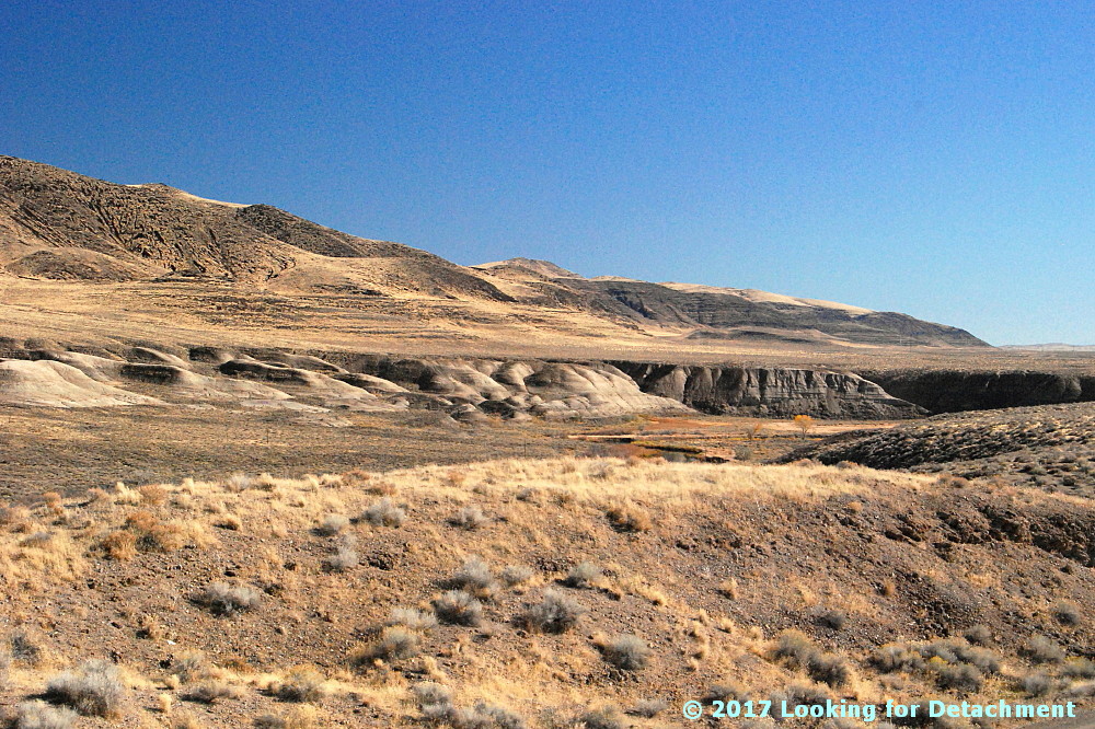
Looking SSE from the historic marker pullout.
These two photos look south-southeastward along the Truckee River toward distant Fernley. A good portion of the river in this area runs parallel or sub-parallel to Walker Lane strike-slip faults. Wadsworth Amphitheater, which shows up in the Google Earth images we'll see in a minute, is not visible from any of our photo sites; it's an amphitheater-shaped topographic feature cut into Lake Lahontan sediments right along the east bank of the Truckee, beyond the dark basaltic hills on the right side of these two photos (east side of the Truckee).
I love the lone Cottonwood in this photo.
I went ahead and drew a few lines on Google Earth, then I rotated the resulting images to two different orientations so we could see a little more of the terrain. Be sure to check the north arrow in the upper right! The linears I drew are parallel or sub-parallel to the trend of the Walker Lane. You might be able to pick out a few more in the images (or go to Google Earth and looking around a bit).

The Walker Lane—on Google Earth (G.E.)and on other aerial representations such as air photos—shows up best at very small scales; that is, if we zoom way out and observe the area from way above, we can see the trend of the Walker Lane better than if we zoom way in, like we've done here. Nevertheless, individual strike-slip faults have been identified throughout the Walker Lane, and a few of these occur right in this area.
The A is centered on Wadsworth Amphitheater. The purple camera icon shows the location of the first photo.
The next G.E. image zooms in to the area we can see in the photos. I've got all three photo locations turned on, the A for Wadsworth Amphitheater, and my drawn-in linears. These linears aren't necessarily faults, although I'm pretty sure the one on the far left is. Unfortunately, because I currently have a very lousy internet setup (thanks Frontier!), I can't load very many research web pages. Google works well—and Blogger is a Google product—so I can blog even with 25 to 100% packet loss (it's 50% this very moment). And because Google Earth is a Google product, it's working for me also! (But I can't routinely access my non-Google email.)

Back to the faults and linears. I do know from personal experience that Walker Lane structures pass through the Lake Lahontan sediments in the area where the Truckee is running in a particularly linear fashion. I know this from some work I did a long time ago with J.O. Davis, who was studying Lake Lahontan and using tephra beds to date various aspects of the stratigraphy. The two linears or faults in the lower right of the image cross through the area where I've seen older Lake Lahontan sediments faulted and highly contorted by the major structures that pass through the area. I can't say that my particular linears are right on the major structures, and I can see other possible lineaments.

UPDATE 3Feb2017: I now have good internet back, and I've been able to compare my "map" to a geologic map of the area (Bell, Garside, and House, 2005). My linear passing through the hatchery location (below) is spot on for their most prominent fault, which was mapped as a dominantly extensional fault.
A zoomed in G.E. view of the area.
Not sure why, but I prefer to spell amphitheater with an "re" at the end: amphitheatre. I also have a hard time sticking the first "h" into the word!

I sure wish Frontier was a better internet service provider! (I never had this kind of semi-routine trouble with AT&T in eastern and northern Nevada; their every-day speeds were faster, and service was (generally) provided more quickly.

Back to the photos! 😊
Horizontal Lahontan shorelines and vertical basaltic talus stripes.
Some of the same talus stripes in Google Earth.
This photo shows a juxtaposition of talus stripes, faint shorelines, and layered Lahontan sediments.
On this trip, I focused mostly on trying to get good photos of the talus, because that's really what caught my eye. I later noticed that a few shots showed the Lake Lahontan sediments fairly well.
White, gray, greenish gray, and pinkish layers of the Eetza Alloformation.
While driving through the area, I'd been assuming that the prominently exposed white units were part of the Sehoo Alloformation. I was wrong! The Sehoo is barely identifiable in this zoomed in photo, and it's the older Eetza that is most conspicuous. In fact, the Sehoo here is mapped as gravelly beach deposits, so it mostly comprises the dark gray or brownish gray layered deposits above the whitish units.

Note: I usually use "formation" when talking about the subdivisions within the Lake Lahontan section, but "alloformation" is technically correct. In explanation, Bell et al (2005) say this, "Lake Lahontan and related subaerial deposits were considered lithostratigraphic units in the early studies of Morrison and were designated as formations. With the revision of the North American Stratigraphic Code in 1983, new allostratigraphic and pedostratigraphic unit definitions were added which allowed the definition of time-transgressive, lithology-independent rock units and soils."
Qsm = middle member of the Sehoo Alloformation; Qe = Eetza Alloformation.
After taking all these photos, it was time to move on, so I looked to the north, in the direction I'd be heading.
What I saw was more talus, more shorelines, and more Lahontan sediments. (And some fall colors.)
Selected Reference:
Bell, J.W., Garside, L.J., and House, P.K., 2005, Geologic map of the Wadsworth Quadrangle, Washoe County, Nevada: Nevada Bur Mines and Geology Map 153.

Monday, January 23, 2017

A Little Report on Our January Storms

Intellicast radar image from 23Jan2017, approx 6:10 am, PST.
Our latest atmospheric river is passing through the area and will probably be gone by tomorrow (for more detail about the atmospheric rivers we've been subject to so far this January, see Garry Hayes' excellent live blogging of the storms here).

It was just three days ago, and this current ongoing storm or set of storms had just dumped an additional 8 inches in our area, which is at about 4560 ft (1890 m) in what is essentially the northern Sierra. The snow was wet and heavy, and had fallen on a base that included wet slush in places and thick snow drifts in others. I thought I'd better head out back to knock the weighty stuff off our fairly young fruit trees.
The gate to the back yard was frozen shut, so I went through our gazebo.
Small fir and pine trees weighed down by ice and snow.
A large cable spool.
As I tramped around in the back, shaking trunks and branches to knock snow off the thin limbs, I post-holed into the snow over the tops of my pack boots, to a depth of about 17 inches. Later measurements of this snow showed that the backyard was covered with about 24 inches.

After my backyard expedition was over, I wandered around taking a few pictures.
Snow on a rickety-looking ladder in our construction area.
A mini-avalanche on the roof from snow falling off a pine tree.
The road in front, not yet plowed, with tire and ski tracks.
Pine branches with snow.
Pine tree with needles plastered with ice and snow.
More plastering.
As I walked around, the temperatures were starting to rise, and large clumps of snow and ice started cascading off the trees. I became fascinated by this process and managed to get a number of action pictures.
The falling clumps drove me under some of our scaffolding structures.
Mostly protected from the falling snow, I felt a little more secure in getting photos without having myself and the camera caught by the falls.


Here I'm still under the scaffolding, looking up at a few large clumps of ice and snow that remain near the top of this pine tree, the same one that created the tiny avalanche above.
Finally, my patience in standing and waiting with camera poised was rewarded with a sizable fall.
One clump remains at the very tip-top of the tree, but it was time to go in to warm up hands and have a cup of coffee.