Thursday, December 24, 2015

Happy Holidays!

Xmas Eve greetings! Photos are all from Nevada City, CA, although I'm elsewhere at the moment. Above: the Outside Inn.
Inside the Mine Shaft.
Likewise.
Xmas cheer from inside Lefty's.

Tuesday, December 22, 2015

Finding a Thesis: Coming into Clayton Valley

On the road to Silver Peak from the east, about six or seven miles past Alkali and while one is still on pavement, Clayton Valley comes into view. The road turns to dirt—gravel and dust—not far beyond this first photo, and not far before the second.
Panoramic view of Clayton Valley in front of the eastern nose of Mineral Ridge.
The same photo, labelled.
In this view, we're looking at Mineral Ridge nearly end-on, essentially down the axis of the mountain-sized anticline that it is. Mineral Ridge, Red Mountain, and the ridgeline on the far left are all part of the greater Silver Peak Range. The ridge, with its high point of 9376 feet (2858 m), hides the range's high point, Piper Peak, and also blocks any view of the Mohawk and Sanger Mines beyond. The reddish brown, dome-shaped Red Mountain, composed of Tertiary rhyolite (Albers and Stewart, 1972), sits at 8957 feet (2730 m) just in front of and to the right of the unnamed ridge. Silver Peak itself is barely in the picture in the left side of the photo—you can see little hints of green if you look closely—just beyond the lithium brine fields of Clayton Valley. The low green slopes on the either side of the dirt road in the foreground consist of natural outcrops of olive to bluish-green shale of the Cambrian Harkless Formation. We'll see more of the cinder cone, The Crater, later in this Silver Peak portion of LFD's thesis-hunting series.
Labelled aerial view of the Clayton Valley–Silver Peak area, courtesy USGS (TNM Viewer link). The lithium brine fields are dead center. "You Are Here" marks the site of the previous photo.
Topographic map of the same view, courtesy USGA (TNM Viewer link).
Past the gap between the north end of Clayton Ridge and the south end of Paymaster Ridge, Silver Peak Road begins to cross the ever-changing lithium-brine fields and ponds. It turns out that there’s a more direct way to Silver Peak from the Palmetto Mountains on dirt via Oasis Divide (off the southwest edge of the map above), but fortunately I didn’t try it back in 1976. It’s a usually washboardy, tire-spinning, sandy road, with lots of inconvenient turns. I doubt the Opel would have made it.

So there I was, finally crossing the large, lithium-brine mining operations in Clayton Valley. (Photos are all from a photo-gathering expedition I made in the summer of 2010.)
Sign near the middle of the lithium brine fields.
The lithium operation, run by Chemetall Foote Corporation back in 2010 according to these signs, is now supposedly owned and run by Albemarle Corporation. Back in '76, it was run by Foote Mineral Company. (The brine mining operation has undergone several name changes over the years.)
More signs.
I'm not really sure what I thought of the lithium brine fields when I traversed the playa from east to west back in 1976, but I probably felt conspicuous and out-of-place. (This was a common feeling during my thesis-hunting adventures: An Opel was fairly uncommon vehicle overall and was even more uncommon off pavement, dirt roads and the Nevada outback were unfamiliar to me, and I was persistently plagued by the thought that I didn't know what I was doing.) Even now, making the crossing can seem a little strange to me, although I did become accustomed to going back and forth across the brine fields back in the mid-1980s when I worked on top of Mineral Ridge. What's odd about the crossing? It's unusual to find such a major dirt road traversing a playa, and what with the all the power and phone lines on both sides, the visual impression is unique. The traffic can be heavier than one usually finds on a playa (barring unexpectedly being on the Black Rock Desert during Burning Man), and one has to watch for trucks and construction equipment.
Silver Peak: about four more miles.
Off to the northwest, the dark prominence of The Crater, a basalt cinder cone, stands out above the salty desert floor.
And there we are: the south end of Silver Peak is to the right.
Read a little more about the brine fields here (USGS, basic info apparently from 1982, still relevant), here (the origin of the brine fields), and here.

Related Posts:
Thesis: Finding an Area
Finding a Thesis: Battle Mountain to Austin to Gabbs
Finding a Thesis: Pole Line Road
Finding a Thesis: Pole Line to Belmont
Finding a Thesis: Klondyke District
Finding a Thesis: A Joshua Tree Aside
Finding a Thesis: Into the Palmetto Mountains
Finding a Thesis: Farther into the Palmetto Mountains
Finding a Thesis: A Bit O' Geology in the Palmetto Mountains
Finding a Thesis: Future Stories from the Palmetto Mountains
Lida Summit Roadcut
Finding a Thesis: Next Stop, Silver Peak!

Tuesday, December 15, 2015

Before We Hike Down Glass Mountain...Some Scouring Stones

Before we go ahead and hike back down from the rhyolite flow on Glass Mountain, take a look, once again, at this view to the south. In the shadows on the right, you can see some beams and timbers from 1930s to 1940s mining operations that produced scouring stones, blocks, or bricks. The trail down took us right past the remains of the old operation (or, possibly, a particular part of the operation: roads snake all across the rhyolite flow). We stopped to look, realizing that anything we might find would likely be rejects, not finished stones that didn't make it into haulage trucks. MOH and I duly grabbed a couple examples.
Scouring stone #1.
The scouring blocks were produced from pumice and vesiculated rhyolite near the top of the rhyolite flow. An old report (CDMG, 1957, p. 2) says:
This pumice occurs as the crust of an obsidian flow and forms jumbled masses of angular blocks associated with black obsidian and dark gray coarsely vesiculated obsidian. Choice pumice blocks are medium gray in color, commonly range in maximum dimension from 1 foot to 3 feet and are relatively free from hard, dense bands. The pumice is loaded into trucks by tractor elevators and hauled to a processing plant near Tulelake where they are cut into "Grillmaster" scouring bricks.
Here's an example of a scouring brick you can buy today.

And here's what scouring block #1 looks like from a couple different angles:
Flow foliation shows well on one of the smoothed surfaces.
As we'll see in the next two photos, we're actually looking at a combination of foliation and lineation on the side shown above.
On the top, here, and down the sides, we can see good flow lineation.
And looking end-on, we see a kind of pock-marked surface: We're looking straight down the flow-lineation tube-like structures. The lineation can be seen in some of the pockety holes.
Scouring stone #2.
A pockety end surface with lineation plus foliation on the other surfaces.
On this smoothed surface, some dark gray or black spots show what the rock might have looked like prior to strong vesiculation.
I'm wondering: Would both of these rocks qualify as pumice by the float-test method?

Thursday, December 10, 2015

Finding a Thesis: Next Stop, Silver Peak!

And so we say goodbye to the Palmetto Mountains.
In actuality, the picture above—taken as I was leaving the Lida-Palmetto area for Fish Lake Valley during my 2010 property-exam trip—has us looking in the rearview mirror at a mine dump located on the west side of the Palmetto Mountains, whereas in our continuing thesis-finding stories, I left the Palmetto Mountains to the east, via the same route I came in on. And so the intertwined 1976–2010 stories continue:

I wasn't too keen about spending another night in the Palmetto Mountains, and so, after duly looking around at a few prospects in the Palmetto mining district, I took my leave by descending the alluvial fan on the south side of the Palmetto Mountains. (In Google Earth, the southwest-facing slope actually looks like a complex of thinly veneered to dissected pediments with localized alluvial fans of more than one age.)  I might have stopped to look at the the ghost town of Palmetto, and I might not have.

After shooting past Lida, I eventually turned north on Highway 95, then turned west onto the Silver Peak Road a few miles north of Goldfield. I then made the relatively easy drive to Silver Peak, partly on pavement loaded with potholes and partly on dirt.

I would have barreled past Alkali and Alkali Hot Springs. Having never bathed there and having stopped only once or twice to look around, I don’t have any good digital pictures of the easily accessible but privately-owned spot.
The Silver Peak Road approaches Alkali from the east. We're looking at the Weepah Hills in the distance beyond the playa known as "Alkali Lake" (original, eh?), and beyond a low part of Paymaster Ridge. The Weepah Hills high point, on the right, is at 7753 feet.
About a half mile past Alkali Hot Springs, a major road junction is marked by a large rock (Google Maps location).
Large rock marking the junction of the paved road to Goldfield (the Silver Peak Road, which we've been on) and the graded gravel road to Tonopah.
Looking NE along the dirt road, back toward Tonopah and the Klondyke Hills.
The rock says, Tonopah: 24 miles.
Looking SE along the paved road back toward Alkali Hot Springs and Goldfield, the latter of which is not visible beyond the horizon. The hazy hills behind the rock are volcanic-capped bluffs in the Goldfield Hills north of Goldfield.
The rock says, Goldfield: 7 miles.

The rock looks volcanic to me; it could possibly warrant further scrutiny, but I've always looked at it as an interesting road artifact. (I've never taken my hammer to it: Heaven forbid!)
Looking WSW from the site of the rock-sign, toward Silver Peak. The south end of Paymaster Ridge blocks the view of all but the highest peaks of the Silver Peak Range miles beyond.
From Alkali, I pushed on to the next stop on my list, the Mary Mine, which is perched near the top of Mineral Ridge, an elongate, nearly oval mountain with the small town of Silver Peak at its eastern extremity. Mineral Ridge proper lies between Silver Peak and Rhyolite Ridge, all technically part of the Silver Peak Range.
Topo map courtesy USGS (TNM link).
Silver Peak is called Silverpeak on this map, as it is on some and not on others. The Board of Geographic Names is now favoring Silver Peak, after naming decisions in 1965 and 1987, so Silver Peak was most correctly known as "Silverpeak" from 1965 to 1987—including when I was there in 1976—and that's probably why some road signs still say "Silverpeak." I also should also have been using the one-word version of the name when I was there in the mid-1980s, but I wasn't. By then, almost no one was (citation: my memory of my own undocumented experience).

Related Posts:
Thesis: Finding an Area
Finding a Thesis: Battle Mountain to Austin to Gabbs
Finding a Thesis: Pole Line Road
Finding a Thesis: Pole Line to Belmont
Finding a Thesis: Klondyke District
Finding a Thesis: A Joshua Tree Aside
Finding a Thesis: Into the Palmetto Mountains
Finding a Thesis: Farther into the Palmetto Mountains
Finding a Thesis: A Bit O' Geology in the Palmetto Mountains
Finding a Thesis: Future Stories from the Palmetto Mountains
Lida Summit Roadcut [essentiall another aside]

Tuesday, December 8, 2015

Twelve Months of LFD (2015)

I'm doing the year-end meme wherein I compile the first sentence of the first post of every month. Meme rules are as follows, as per DrugMonkey:
Post the link and first sentence from the first blog entry for each month of the past year.
I've also added the photo from the same first post, if there happened to be one. I've removed any captions from the photos, so if you want to find out more about locations, etc, you'll have to click through. The first sentences include some classically long, LFD-style sentences, one short sentence, and many that are in between. Previous takes on this Twelve Month meme at LFD were posted for 2008, 2009, 20102012, and 2014.

Aaand...here's the year 2015 for LFD:
January:
A year ago today, a thin snow highlighted some Lake Lahontan shorelines on basalt-capped hills out in (or near) the Fernley Wildlife Management Area (FWMA):

February:
Yesterday, when out hiking in nearby Water Canyon (before the Super Bowl), MOH and I slowly (at least for me) made our way up a variably steep, grassy to rocky hillside until we came to a large rib of quartzite.

March:
Well, I'm back at the place I was working at about two years ago (see these three posts for more info), spending more time on a back paved road and on dirt roads than I was most recently while on the road to work (I'm still driving on the interstate some, but a lot less than during the last two years).

April:
It was a very windy day as I drove south along what's variably called the Surprise Valley Road or the Sand Pass Road (and to the north, is often called the Smoke Creek Road) into the Pyramid Lake Paiute Tribe's Reservation.

May:
It is often — more commonly than in the past, IMO — hazy or dusty in north-central Nevada where I routinely work and often travel, here and there across basins and over ranges.

June:
An El Niño has supposedly set in (starting when, exactly, I'm not sure).

July: Nada. Zip. Zero.

August:
Neil Young: Rockin' in the Free World (lyricsAlbum: Freedom, 1989
This is technically a road song because it mentions streets twice and roads once, and because the video that came out with the song also shows a lot of streets.

September:
There I was minding my own business while flying north from RNO to SEA (that is to say, I was reading a thick book and trying to ignore a seatmate while crammed against the window near the rear of a Q400), when I looked out (to the east) and spotted the peak of an Oregon volcano sticking out through what I first thought was a low, thick cloud cover.

October:
South of the Klondyke District (our previous stop on this journey) and just north of Goldfield, one reaches one of the northernmost populations of Joshua trees (Yucca brevifolia)—or the northernmost population, depending on what range map you use.

November:
In later years—in the future of the 1976 "present" of these ongoing thesis-hunt stories—I made my way back into the Palmetto-Magruder area barely a handful of times.

December:
When I pulled up to Lida Summit two years ago—I was on my way to a property examination and had decided to check out the Lida and Palmetto areas—I stopped right in front of...a roadcut!

Tuesday, December 1, 2015

Lida Summit Roadcut

Here we are, back at Lida Summit, looking west on S.R. 266.
When I pulled up to Lida Summit two years ago—I was on my way to a property examination and had decided to check out the Lida and Palmetto areas—I stopped right in front of...a roadcut! Well, that’s really no surprise, is it? Where else would a geologist stop, other than at some excellent viewpoint? (Acutally, the spot I selected, as you can see above, also came with a view of the mountains beyond, including the high Sierra.)


Offhand, I can think of a few places where a geologist might park or pull over other than roadcuts or viewpoints. For one, I would park off a paved road! And while down some dirt road away from traffic, I would park in a place that wouldn't allow my truck to roll forward or backward even without chocking the tires with a rock or chock blocks. That spot might be some random wash or ditch of some kind—if I thought the low area was out of the way of any potential flash flood—or it might be on a hill, provided the truck wouldn't roll when I let out the clutch: a site with a natural declivity or some in-place, roll-resistant rocks. Then I'd chock the truck anyway.

Speaking of ditches, that brings me to a second possible parking position: a hidden spot. While in the field I might not want to advertise my presence for a variety of reasons. For example, I might decide to indulge in some sort of exploration espionage and therefore wouldn't want my presence to be suspected. Mostly, though, I'd chose to conceal my vehicle, and thus my presence and general whereabouts as a means of personal protection: in order to hide myself from random strangers who might prove to be a threat.

A view of the summit from the west side: summit ahead, roadcut right.
And here's the roadcut. My truck is alongside for scale.
At first glance this is a rather unprepossessing roadcut: The rocks shine white in the sun, they show some jarositic to goethitic iron-staining, I detect a crude layering (am I imagining this?), and there appears to be a vertical jointing pattern. Also, I see a reddish brown soil or slope-forming layer beneath the resistant mini-cliffs.

Is the rock in our roadcut igneous (granitic rock or rhyolite, perhaps), sedimentary (blocky-weathering siltstone, perhaps), or metamorphic (quartzite, maybe)?
It's ash-flow tuff!
I was a little surprised to discover that the roadcut was in ash-flow tuff: I had been thinking more along the lines of granite or siltstone. Also, an elevation of 7400 feet seems a bit high for ash-flow tuff given the much lower current elevations of likely source calderas (Basin-and-Range faulting has no doubt changed the relative elevations of calderas and associated ash-flow sheets in some areas). Possibly, rather than thinking I could tell what the rock type was before I had even slowed down to look (I was going warp what?), I should have been a responsible geologist and selected a designated driver. or I maybe I should have somehow known to drive slow enough to see the micro-texture. I guess I was focused on the larger picture.

Vertical jointing stands out clearly in these photos. I’m not sure from this one exposure if the jointing qualifies as poorly formed columnar jointing, but it looks quite possible. Columnar jointing is fairly common in some parts of ash-flow tuff sheets, especially in the strongly welded zone. The jointing is often rectangular to square (Ross and Smith, 1961), though it can also be five- or six-sided, as is common in basalts. Consequently, it's not always possible to tell the difference between basalts and dark-weathering, columnar-jointed ash-flow tuffs from a distance.

Hints of the strong eutaxitic texture present in this exposure can be seen cutting subhorizontally across the photos, with the planar feature dipping more or less to the right (that would be in an easterly direction).
In this photo, the eutaxitic texture becomes, perhaps, slightly more visible.
Strongly or densely welded vitric ash-flow tuff.
Most of the rock lying along side the road below the roadcut looked like the rock above: white or very light gray to very pale yellowish gray strongly welded vitric ash-flow tuff, with a eutaxitic texture defined by highly compacted (or collapsed) light pinkish gray pumice fragments: the elongate, lens-shaped fragments with tapered or pointed ends: fiamme. The rock contains tiny crystals not easily seen in the photo, and lithic fragments that are small and sparse (at least in the hand samples I examined).

Back in the semi-dark ages, I learned, somewhat incorrectly, that the term "fiamme" refers to the tiny flame shapes at the end of flattened pumice lenses in rocks like these. I also learned to call the lenses "flattened (or collapsed) pumice," rather than "fiamme." The lenses are definitely fiamme, even though Ross and Smith (1961) used a definition that might seem more specific than the one commonly used today. They defined fiamme as
"the Italian name used to describe black glassy inclusions in piperno and which have a cross section shaped like the tongues of flame. These are often several centimeters in length, but may range from microscopic size to several feet in length,"
where "piperno" is a rock characterized by lenses of glass.

The definition and genetic interpretation of fiamme is addressed at length by Bull and McPhie (2007). They point out that the presence of fiamme is not diagnostic of welded ash-flow tuff (the same way that the absence of fiamme is not diagnostic that you are looking at something besides a welded ash-flow tuff).
Moderately or strongly welded lithic-rich vitric ash-flow tuff.
I'm not sure if this rock is part of the same unit or if I've picked up a piece of some float from some other ash-flow tuff. It's pinkish, rather than whitish, although color doesn't technically matter in correlation; it contains a considerably higher proportion of lithic fragments, although that could be a function of being somewhat less welded, and lithics can be concentrated in layers or swarms within an ash-flow sheet. The matrix of the rock shows some similarity to the matrix of the first rock sample: it consists of devitrified glass with collapsed pumice, but it appears to contain a higher percentage of tiny crystals.

We can examine these rocks a little more closely.
An enlargement from ash-flow tuff #1.
An enlargement from ash-flow tuff #2.
For my part, I go for them being from separate units at this point, but further examination, some mapping, and thin sections would be required to be sure.

Related Posts:
Thesis: Finding an Area
Finding a Thesis: Battle Mountain to Austin to Gabbs
Finding a Thesis: Pole Line Road
Finding a Thesis: Pole Line to Belmont
Finding a Thesis: Klondyke District
Finding a Thesis: A Joshua Tree Aside
Finding a Thesis: Into the Palmetto Mountains
Finding a Thesis: Farther into the Palmetto Mountains
Finding a Thesis: A Bit O' Geology in the Palmetto Mountains
Finding a Thesis: Future Stories from the Palmetto Mountains

Post updated 2Dec2015 to add related posts.

Tuesday, November 24, 2015

Views from Glass Mountain

After we finally arrived at our chosen overlook part way up Glass Mountain, we milled about a bit (it was a geology field trip, after all), and then we gathered 'round a map that one of our tour leaders, Julie Donnelly-Nolan, had placed on the ground.

Above, my rock hammer is in front of blocks of relatively light-colored, vesiculated, rhyolite obsidian (AKA pumice, but in this case it's pumiceous flow-rock, not tephra).


Before I get to a few views of the area, I'll go into the geology just a little:
Julie Donnelly-Nolan points to her map of the Glass Mountain dacite-rhyolite flow, Siskiyou County, CA.
The map, not included as part of our field guide packet (Coyner, 2015), was created by Julie, a geologist for the USGS. She's been working in the area for many years. The map is similar to a map by Eichelberger (1981), which he published in an article about magma mixing at Glass Mountain, an article that is part of a larger field guide to several volcanic areas in Idaho, Oregon, and northern California (Johnston and Donnelly-Nolan, 1981). The road log for the Glass Mountain part of our GSN trip was taken in large part from the Medicine Lake Highland road log section of that larger field guide (Donnelly-Nolan et al., 1981). If you check out the guidebook, be sure to read Wes Hildreth's tribute to David A. Johnston, who died at Mt. St. Helens in 1980. The 1981 field guide was published after his death.

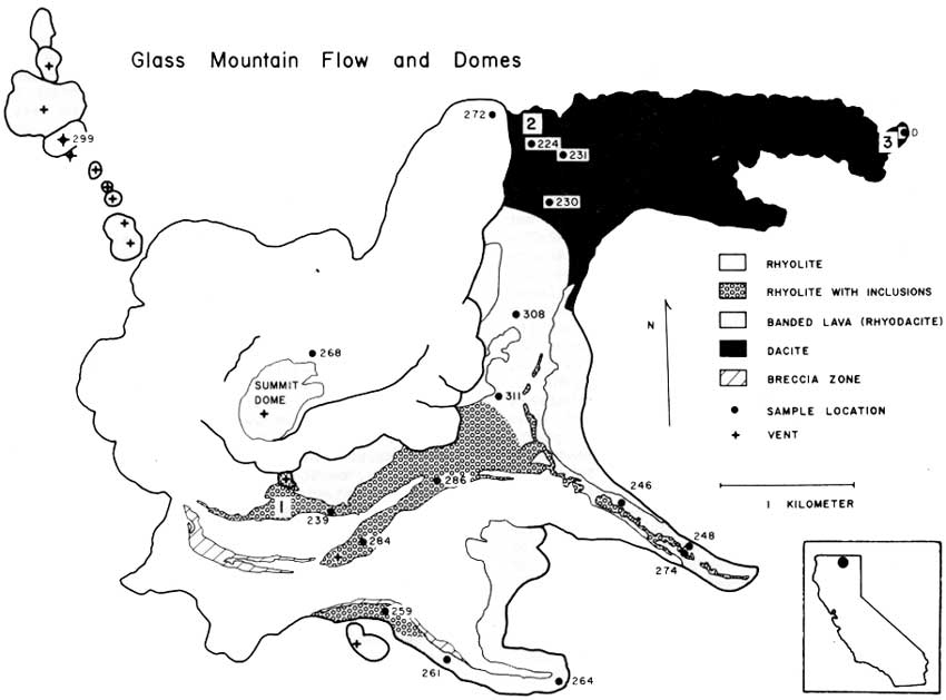
As you can see below in a rotated version of the map, the Glass Mountain dacite-rhyolite flow "consists of three dacitic eastern lobes which grade westward to rhyolite and are overlain by rhyolite lobes" (Donnelly-Nolan et al., 1981, and in Coyner, 2015). Well, maybe not all of that is obvious at first glance, but read on.
Map showing the silica content of different parts of the Glass Mountain dacite-rhyolite flow (Donnelly-Nolan, unpublished). North is up.
During the rest of this post, I'll be referring to the dacite flow lobe (purple, in the northeast), the rhyodacite flow lobe (red with a central ribbon of orange, in the southeast), and the south flow lobe (mixed orange, red, and purple, in the south to southeast). I'll also mention the rhyolite flow lobe (the central and northern orange area, including a well-definable flow and central dome area with margins that overlap the slightly older dacite and rhyodacite lobes), and the mixed area centered between the dacite and rhyodacite lobes.

On the map, the highest silica parts of the flow, the rhyolite, are in orange; the parts of the flow with lowest silica content, the dacite, are in purple; the areas with silica content in between rhyolite and dacite, essentially rhyodacite, are in red. NOTE: Though by many classification schemes the silica content of rhyolite is about 68 or 69% and higher (the USGS appears to be using two different cutoffs), and the silica content of dacite ranges from about 63-68% or 69%; TAS diagrams show dacite compositions as high as 72-75% (depending on what version of TAS one happens to choose; here's one; TAS explained here and here; and a lot more about the classification of igneous rocks—including all kinds of diagrams, references, and a flow chart—can be perused here). Rhyodacite is a term generally used for rock composisitons between rhyolite and dacite (USGS, OSU), rather than a specific field in most classification systems.

The colorful map (I love color!) shows that the lithologic composition of the overall flow, which is thought to have erupted during the course of several or many days or weeks rather than over several months or years, is quite variable. The complexities of magma mixing and eruption to produce this variability are described by Eichelberger (1975, 1981). Basically, it's complicated: first, basalt intrudes a rhyolite magma chamber; then mixing creates rhyodacite and dacite, which float to the top of the chamber in his eruption scenario; eruption, triggered by the mixing, produces dacite, then rhyodacite, then rhyolite.

Below, I decided to see what kind of map I would come up with going mostly by color and topographic expression of the flows (with a lot of help from Julie's map).
Google Earth image of the Glass Mountain dacite-rhyolite flow.
Here, I've delineated the dark areas with purple lines, the light, viscous, and some banded areas with orange lines, and the in between areas with red lines.
You can see that there are several areas where the lines I've drawn could be moved around, for example some of the banded areas: do they belong properly in our red or orange category?
I've added some colorful fill to facilitate comparison to the geologic map.
Here's the rotated map again (and it's skewed).
My "map" or cartoon as drawn on the Google Earth image is comparable to the rotated geological/compositional map (yay!); but really, this was just an inconsequential exercise, one that could have easily produced a considerably different map, possibly by using as many as 5 major fields (for example, if the banded-looking areas were picked out separately, and with the upper, well-defined rhyolite flow that heads off to the northeast drawn as a separate unit). Without chemistry or an already existing geologic map, this is the sort of exercise that could be done prior to heading into the field, giving the mapper an idea what to check out, although just taking an aerial image or air-photo into the field would serve the same purpose.


Well, that was really a kind of long aside, almost like a post within a post!

Besides hanging around the map and hefting large rocks, the view from the east side of the rhyolite flow (see our location below the post) was good—not great simply because of the low-hanging clouds that hadn't lifted.
Photo looking south.
I thought I might have the actual top of Glass Mountain in this photo, way over to the right, but the dome-shaped peak was covered with clouds. Instead, we can see the steep face of the rhyolite flow where it abuts a highly mixed part of the flow: the central section between the rhyodacite and dacite flow lobes (see map above).
Photo looking nearly due east.
This view looks out across the dacite flow lobe (dark brown and mostly in shadow past the light-colored rhyolite blocks in the foreground). Timber Mountain, the circular, gently sloped mountain dead center in the distance, is shown to be underlain by the the "older basaltic andesite of Timber Mountain" on Sheet 2 of this map (Donnelly-Nolan, 2010). It has been dated at 1.820±0.042 Ma, i.e., late Pliocene.

Oh, and btw, the Glass Mountain flow erupted about 900 years ago: it has a calibrated radiocarbon age of 890 BP (Donnelly-Nolan et al., 2007).
With the blocky rocks of the dacite flow lobe in the foreground, we look northeasterly in this photo. That's probably Double Head Mountain just left of center; the north edge of Timber Mountain is on the far right.
And now, we've already started back down. I'll have a few more photos along in a while...

A Few References:
A Web Browser Flow Chart for the Classification of Igneous Rocks - a lot of info (largely from Le Bas and Streckeisen, 1999, and other related sources), and a flow chart

Tephra and Volcaniclastic Rocks - good overall classification scheme, though it doesn't reference any primary sources, and allows agglutinate to occur only in basaltic rocks

Coyner, Alan (ed.), 2015, Geological Society of Nevada 2015 fall field trip guidebook: Geology of the Far Northwestern Great Basin: Quartz Mountain gold deposit, Oregon, and Lava Beds National Monument and Glass Mountain Pumice Deposit, California [for sale here, but not yet listed]: Geological Society of Nevada, Special Publication No. 60, 71 p.

Donnelly-Nolan, J. M., 2010, Geologic map of Medicine Lake Volcano, Northern California: U.S. Geological Survey Scientific Investigations Map 2927, scale 1:50,000, Sheet 1 and Sheet 2, Pamphlet to accompany the map, 48p.

Donnelly-Nolan, J.M., Ciancanelli, E.V., Eichelberger, J.C., Fink, J.H., Heiken, Grant, 1981, Roadlog for field trip to Medicine Lake Highlandin Johnson, D., and Donnelly-Nolan, J., eds., Guides to some volcanic terranes in Washington, Idaho, Oregon, and northern California: U.S. Geological Survey Circular 838, p. 141–149.

Donnelly-Nolan, J. M., Nathenson, M., Champion, D. E., Ramsey, D. W., Lowenstern, J. B. & Ewert, J. W., 2007, Volcano hazards assessment for Medicine Lake Volcano, Northern California: U.S.Geological Survey Scientific Investigations Report, 2007-5174-A, 26 p

Eichelberger, J.C., 1975, Origin of andesite and dacite: Evidence of mixing at Glass Mountain in California and at other circum-Pacific volcanoes: Geological Society America Bulletin 86, v. 10, p 1381-1391.

Eichelberger, J.C., 1981, Mechanism of magma mixing at Glass Mountain, Medicine Lake Highland volcano, California, in Johnson, D., and Donnelly-Nolan, J., eds., Guides to some volcanic terranes in Washington, Idaho, Oregon, and northern California: U.S. Geological Survey Circular 838, p. 183-189.
jpg of lava chemistry figure (Eichelberger, 1981)

Hildreth, Wes, 1981, David Alexander Johnston, 1949-1980in Johnson, D., and Donnelly-Nolan, J., eds., Guides to some volcanic terranes in Washington, Idaho, Oregon, and northern California: U.S. Geological Survey Circular 838, p. viii-x.

Johnston, D.A., and Donnelly-Nolan, J.M., 1981, Guides to Some Volcanic Terranes in Washington, Idaho, Oregon, and Northern California [pdf version; also here in html]: U.S. Geological Survey Circular 838, 189 p.