Showing posts with label bad roads. Show all posts

Tuesday, April 5, 2016

Death Valley Trip, Getting There: A Jeep Trail, Folds and Cartoons of Folds, Even More Folds, and Boundary Peak

An unnamed portion of the Gabbs Valley Range.
From the vantage point of the end of the last post, a little southwest of Luning, Nevada, I turned around and pointed my camera northeast across Soda Spring Valley ... and paused to think back to the late 1980s, when we in the Western District of Former Mining Company had finally taken over exploration of the Walker Lane, which until then had been a mostly unexplored part of the Nevada District. We drove all the roads in the area—up canyons, over ridges, and across saddles—and one thing I remember in particular was coming over the top of a low ridgeline from the east, on a jeep trail that dived and went into a series of moderately sharp switchbacks as it approached some old mine workings.
The road in question is below the arrow.
Ah yes, the memories. We found a gold-bearing skarn—it's not quite in view in the photo above—and after some sampling and sketch mapping, we debated targeting some drill holes, but decided it was too small for our target size.

Back to the road itself. Coming over the top from the east (something I'm not likely to do in any near future that I am aware of), the road immediately drops and dives around a curve, making it hard to judge the condition of the road ahead. We maneuvered to some particular point and stopped. What the H! We would have to do a bunch of walking to actually explore the area anyway, so maybe it would be better to stop here at this turn-around spot than to go farther and find that the road requires backing up on steep slopes around sharp turns.

I don't really remember how we handled the sampling logistics. Sometimes it's easiest to drop a couple people off near the top and then meet them at the bottom later in the day, after they've sampled the upper slopes and you've sampled the prospects in the lower hills. Or maybe after a bit of walking around, we found the road acceptable and drove on down.
The road as seen in Google Earth. It's downhill to the lower left (SW).
The Google Earth view of the road is somewhat impressive *in* Google Earth; here's the Google Maps link in case you want to find it on Google Earth.

The view from the upper part of the jeep trail was grand. I've tried below to simulate the view by sloppily stitching together two Google Earth images:
Walker Lake is off in the upper right (W), Luning is just left of center on the other side of the beige plain (SW); Mina is out of the picture to the left (S). 
After grabbing the first shot or two, I pointed my camera more to the east—a little north of east, to be precise—at a folded part of the Gabbs Valley Range, another area we explored back in the late 1980s.
The notable landmark of this part of the Gabbs Valley Range is a dark pimple of a peak to the right of center: Volcano Peak.
Volcano Peak is not a volcano; rather, it is underlain by tilted beds of the Upper Triassic Luning Formation, which consists mostly of limestone, dolomite, and shale.
Zooming in, we get a better view of Volcano Peak and can identify a few old porphyry copper drill roads that probably date back to the 1960s or 70s.
In a similar Google Earth view, we can begin to see a fold nose, centered and just above the dark line (a Google Earth artifact).
I've cropped this image so I could zoom in farther. The upper drill roads are more apparent. Volcano Peak is now on the far right.
It can be fun to take a shot at the geology by drawing lines on photos like these, or on air photos. Drawing without checking the geology first can be chancy, if one is concerned about being right, as can drawing without checking the geology in the field afterward.

Before checking the geology, I came up with the following cartoon, wherein I assumed many features to be stratigraphic beds, and assigned a few other features to faulting.
Here's my first cartoon, with presumed bedding in cyan and a few tentative high-angle faults in dark purplish blue.
I wondered if the central dashed line across the first cartoon was a low-angle fault of some kind.

After concocting the first cartoon, I checked out the geology as mapped by Ekren and Byers in 1985. It turns out that I missed a large blob of quartz monzonite (mapped as JKqm).
The quartz monzonite is outlined in red.
The central line, which was dashed in cyan in the first cartoon, has now been drawn in dark blue, a mapped fault. It's a high-angle fault, however, and it's just our angle of viewing that makes it look horizontal. (Here we can see why apparent dip matters so much: from this angle, the dip looks to be nearly zero; in reality, it is closer to 90 degrees, although that's a guess, as there is no measurement of it on the geologic map.) The quartz monzonite is cut by this high-angle fault, which is down-to-the east, dipping eastward away from us. I left in the cyan bedding emphasizing the fold, and I left in my still tentative high-angle faults in dark purplish blue (toward the right).

These two cartoons show the problem with assuming too much from photos (or air photos). Features that look like bedding might, when field checked, actually be faults, dikes, or other structures like joints. In this when case, we checked the cartoon against a geologic map of relatively small scale, 1:48,000 or 1 inch = 4000 feet.

Somewhere in these canyons, way back in the late 1980s, we came across an old, partly broken-down core shed. The shed was mostly intact then, but the core had started to become scattered, either from vandalism or from the escalating disintegration of the core boxes (or both).


By this time on our trip to Death Valley, it seemed that we should be farther along, but we hadn't even gotten to Tonopah! So we moved on, but almost immediately we decided to stop not far down the road: it was getting to be lunchtime. Just before Mina, we pulled off the highway onto a major dirt road that goes eastward between the Gabbs Valley Range and the Pilot Mountains.
Looking southeast toward the Pilot Mountains from a broad alluvial plain above the town of Mina. Pilot Peak is hidden from view behind the unnamed, lightly snow-dusted, >8500-foot-high peak.
A lot of folding, thrusting, and possibly some low-angle normal faulting has occurred in the Pilot Mountains. In fact, the area is (or should be) one of the type localities for the Luning-Fencemaker fold-and-thrust belt.

While eating a cheese-bologna sandwich, I took a few photos of some of the folds. Some recumbent folds are actually better viewed from another road, but I forgot about that until looking around in Google Earth.
Folds! This is probably mostly Luning Formation limestone and shale, with some Tertiary volcanic rock in the lower left.
More folds!!
The potential here for great fold photos only increases with time spent in the area, and driving up into the hills would do the same.
I turned away from the folds to take this shot of Boundary Peak.
I grabbed this photo of Boundary Peak, hoping that MOH and I would get even closer later in the trip (and we did!). The photo shows both Boundary Peak (the highest peak in Nevada) and the higher Montgomery Peak, which is right behind it and slightly to the right in this photo—look carefully!

We'll continue our journey after lunch. We'll be stopping at Redlich and the Boss Mine. We'll see desert pavement and a cholla. We'll see Boundary Peak again. We might spy some breccia and a solar power plant.

Location map

Related Posts (in order of posting):
Death Valley, "Super" Blooms, Turtlebacks, and Detachments
Death Valley Trip, Part 2: More of the Badwater Turtleback Fault
Death Valley Trip, Part 3: Northward, and over Daylight Pass
Death Valley Trip, Getting There: Wave Clouds beyond the Sierra
Death Valley Trip, Getting There: A Hike to Pleistocene Shorelines
Death Valley Trip, Getting There: Walker Lake, Road Stories, A Bit about Copper, and Some Folds near Luning

Tuesday, November 3, 2015

Future Stories from the Palmetto Moutains

It's 58 miles to the next gas station at Lida Junction on S.R. 266, looking west.
In later years—in the future of the 1976 "present" of these ongoing thesis-hunt stories—I made my way back into the Palmetto-Magruder area barely a handful of times. Once, while taking a back way into Death Valley in the fall of 1986, we made some stops between Lida Junction and Lida to find some blackbrush. This notably unsuccessful endeavor was instigated by a palynologist—he preferred the pronunciation "pollenologist"—who swore he would surely be able to show us some fine examples of the cryptic bush (cryptic to us). At the time, however, most of the bushes lacked leaves (it was fall, or extra dry, or both), and while many had the dark grayish woody stems and trunks reportedly diagnostic of blackbrush, it was nigh impossible to tell one bush from another. Our palynologist couldn't positively identify a single bush! I’ve consequently never been able to ID the plant.
Corral near the junction of SRs 266 and 174, the road to Gold Point. Halogetin in the foreground, unidentified scrub beyond the fences. 


And now I'm going to deviate from my usual format to tell a story that may or may not have occurred in the Palmetto Mountains, one which I am assured by a certain geo-type, who may or may not have been present, not only did not occur, but could not possibly have occurred. Some details may or may not have been changed in this retelling. Any similarities to certain Former Mining Company trips made in the area during the mid- to late 1980s are unquestionably coincidental.

There were four of us geo-types, four geos on a 2-truck expedition into an area of old mining prospects on the south side of an east-west-trending mountain range in a relatively arid area. The sun was high in the sky, as it often is at about midday. The white Chevy pickup (this part is clear in my mind) was ahead of me, going more slowly than would have been comfortable in my company truck, which was a half-ton, 4WD Ford pickup, probably an '85. The Ford could take the deep washboard that was pervasively present through the area at higher speeds than the Chevy because of its better sway bars and other off-road accoutrements. (I know, I know; this sounds like a trite Chevy-Ford rivalry.) Consequently, I was staying a ways back, letting "the guys" go ahead. (In my truck, we were two youngish women, both geologists.)

And now we come to the controversial part of this possibly apocryphal story.

The two ahead of us—those two in that white Chevy pickup, the truck that also lacked enough gumption to go up hills in anything higher than middle gear (I won't mention here its barely SFW nickname)—took off on a hummocky-looking, powdery-textured two-track that was running straight up a steep hill. I won’t exaggerate and say this was the steepest dirt road I’d ever seen (or driven on), but something about it, besides my aversion to being right behind someone on a dirt road—ugh, the dust!—made me stay at the bottom of the hill while I watched them ascend steeply and make a sharp, overly banked turn to the right.

Up ahead in the distance, they stopped. By now we could either barely see them, or they were beyond our sight. We, who had stayed below, walked on up: it wouldn't be that far to the next prospect, and we wanted to check out the road. Oh, look! Beyond the curve the road cuts straight across the hill at a complete sidehill! Any forward or backward movement and the rear end will slide out! (The rear end is usually the part to go first; a complete roll down the side of the mountain is less common).

Disclaimer: The driver of the white truck maintains that there was no sidehill too steep for the truck at this particular locale (which I remember as being in the Palmetto Mountains), and that there was no winching uphill to a Joshua tree in progress when I showed up on foot (and no winching to any Joshua tree ever, anywhere). And the usual statement—pictures, or it didn't happen—could apply. There definitely were no pictures.


I’ll stop for now, not to leave anyone hanging or anything, and will come back to the Palmettos once more, with some roadside geology.

Related Posts:
Thesis: Finding an Area
Finding a Thesis: Battle Mountain to Austin to Gabbs
Finding a Thesis: Pole Line Road
Finding a Thesis: Pole Line to Belmont
Finding a Thesis: Klondyke District
Finding a Thesis: A Joshua Tree Aside
Finding a Thesis: Into the Palmetto Mountains
Finding a Thesis: Farther into the Palmetto Mountains
Finding a Thesis: A Bit O' Geology in the Palmetto Mountains

Tuesday, September 23, 2014

Dust Hole

I was out driving around the other day, basically following I-80 from Lovelock to Reno, and I decided to take what I thought would be a short side trip, getting off at Toulon to check out a bit of remaining old Highway 40 just east of the Humboldt Dike.

After checking out the old alignment, I thought about turning around and going back to Toulon to get on the freeway, then decided to go on toward the old site of Trinity, where U.S. 95 south to Fallon meets I-80. Go forward, not back! To do this, I drove southwest on an easy portion of what turned out to be a long, tedious, and very rocky section of powerline road.

Near the top of the first rise, the road narrowed and turned rocky and then went into the first of a series of sideways excursions across several large and small washes coming south out of the south Trinity Range. Near the bottom of the first of these washes, I pushed my way through a small silt hole (I was already in 4WD in order to go slower over the sharp volcanic rocks). Rather than stopping and backing through the thing or trying to turn around at this somewhat late point (and thinking that Trinity would be just over the next rise), I kept going, only to suddenly find myself heading into an immense, roiled dust hole cut into old Lake Lahontan lake sediments (or Tertiary intra-volcanic sediments). I leaned on the gas pedal, thinking that if I came to a stop in the middle of the hole, I would be stuck and would have to send a SPOT help message or walk out to I-80 (or both). Waves of dust washed over the jeep covering it entirely, and for the last part of the hole, I couldn't see a thing. I didn't have time to turn on my window wipers, which probably wouldn't have helped anyway, and I kept going like a person with their eyes shut, trying to remember the next part of the road from the brief glance I had gotten.

I made it through, and instead of stopping to take any pictures of it, I continued on, just wanting to get the hell out of there. After a steep bit or two through rocks I actually scraped over a little (this is hard to do with the excellent clearance the jeep has), I arrived at the top of the next rise.
On an obscure powerline road, looking southwestward toward Trinity.
From the top of the rise, I could see that I had at least one more major wash to cross and more than a mile to go. At this point, I was just short of half way there (although I didn't really know that at the time), and I knew that I wouldn't be turning around to go back to Toulon, because I wasn't going to drive through that second dust hole twice in one day. (Or ever again!)
Here, I'm looking northeast across the wash I had just crossed.
Both dust holes are visible in the photo enlargement below, just right of the powerline in roiled, light-colored sediments in the center of the broad wash area:
From looking at this in Google Earth, I'm pretty sure that only the beginning of the second dust hole (the one closest to us) is fully visible in the photo.
I was running enough adrenaline right then, that I didn't try harder to get a better picture — I was focused more on getting out of there as quickly as possible and getting back to the highway!  I hurriedly cleaned the dust off the windows of the jeep, and drove on toward Trinity.
The view of the second hole that I would have had if I'd walked back over the hill a short distance.
When I got to Trinity, I took out the air filter out of the jeep and shook the dust out of it.

View Toulon to Trinity in a larger map

After getting onto I-80, I accelerated to traveling speed (warp 7.5+ or 75-80 mph; warp speed terminology on roads and highways explained here), leaving a trail of dust behind me for several miles, perhaps as far as about halfway to Nightingale Hot Springs.

Phew! Maybe I'll go back someday to get a better photo of the hole. Maybe.

(See embedded Google Maps view above for location of all geographic points of interest mentioned in this post.)

Thursday, April 4, 2013

Things You Find in the Field: Roads You Shouldn't Take

The road we'll be taking a look at begins at a circular parking area (above and below), and heads up the ridgeline to the right of the drainage centered in the "Bad Road" Google Earth image (above). I haven't attempted this particular road myself, and don't plan on it without walking the mid-slope part of it carefully. Actually, I don't plan on attempting it at all: It looks like a road for "high-markers."
The Prius parked in the circular parking area below the hill climb, which begins just left of the photo.
Having no photos of the beginning of the road, here's a view from Google Earth.
This first part of the road really looks just fine, and there is an almost flat area just over the first rise for turning around.
View of the upper part of the road, which forks.
The main part of the hill climb continues uphill on the right-hand fork, into or through one patch of rocks, and beyond into another. The left-hand fork looks like it's been used to access vehicles that have rolled or slid downhill into the gully.
Closer view of the bad area below, through, and above the rocks.
This part, and maybe the curve just below the fork, looks rather sidehilly from below.
If you happen to make it up this far (into the first set of rocks), don't look back! Instead concentrate on going forward!
Otherwise you might end up in the gully. Vehicle parts are scattered all over.
Interestingly, it appears that Google Earth and Maps captured a vehicle in the process of being dug out. (Click to enlarge, or view here.)
Uphill, the road appears to end in rocks and a series of individual tracks, some of which go back down into the gully.

Instead of this questionable road, I'd recommend taking the switchbacked road that takes off just left of the circular parking area (first photo, with Prius). This road is very rocky in a couple places and requires a high-clearance 4WD vehicle. (We saw a low-clearance vehicle turn around at the first switchback just the other day.) The switchbacked road will take you up to the main ridgeline road, an adventure for another day.

Photos taken in middle and late March during two hikes up the switchbacked road.

Tuesday, February 19, 2013

Things You Find In the Field: World's Worst Road?

A road not taken.
Its beginning located here in Google Maps.
Back in 2009, MOH and I were heading up this road in search of a particular "world's worst road," when it turned out we were on very old access road, which soon petered out into the creosote.
Continuation of the road not taken, with destination canyon off in the distance below the faintly pinkish exposure just right of center.
We were heading up toward a road that went up a long canyon, which began at the top of the alluvial fan in the distance. I wanted to drive the canyon road to remind myself about good roads and bad roads. The canyon road, being entirely passable by almost anyone in a high-clearance 4WD vehicle, was merely tedious and quirky at its entrance into the canyon from the top of the alluvial fan. Giant rocks, embedded in the fan, stuck out here and there, almost always precisely in the wrong place. The rock placement, along with considerable rutting of the road on its downhill side, made severe scraping of differentials and other low-hanging parts and lines moderately likely, even highly possible.

I was first led up the canyon by a prospector/submitter/promoter, who wanted to show me some claims of his (or his company's), which were south up the long canyon road, then west beyond some steep or somewhat precarious switchbacks, and then farther west on the other side of the mountain ridgeline. I don't remember our driving arrangements, but I do know that I always prefer to go into the field in my own vehicle (or a company vehicle if one is available), and that, as far as I can remember, I have never been escorted by prospectors onto their claims without me driving my own truck behind them.


An Aside: Prospectors—who are not geologists but are people who may make a living or add to their regular living by staking and leasing mining claims to exploration and mining companies, their regular living often being related to ranching, possibly to small market or gas station ownership, perhaps to small or large equipment operation (think cat operator), or perhaps including or primarily being related to retirement income of some sort, and which can be related to any other type of occupation including real estate—are often men, but I have known or met at least two non-geologist prospectors who were women.

I don't, BTW, consider myself a prospector, although my work can require me to conduct prospector-like activities, which, as a professional, I call exploration. The (IMHO) erroneous labeling of trained persons with geology or other related earth science degrees as prospectors, came up on Twitter recently. I reject any assertion that professional explorationists can be called "prospectors"—except as a colloquialism—and reserve the term for that used-to-be large, used-to-be ubiquitious (in Nevada, and perhaps in southern California, although a Mojave or otherwise California version of a true prospector is hard to come by: the Mojave version is, in my experience, more likely to be a scam artist), and used-to-be crucial (to the mining industry) contingent of non–geo-type individuals found out and about throughout the backcountry, banging on rocks or panning for gold, staking and maintaining their claims.


Back to Roads: There are numerous roads here and there in the west, and especially in the Mojave Desert of southern California, that could perhaps qualify for submission to the world's-worst-road competition. In that competition, I'd consider only roads that are theoretically passable, even if one might have become stuck while driving said road. (Getting stuck can result both from driver error or misjudgment and from nasty or terrible road conditions.) Some roads are impassable (or nearly impassable) for short periods of time—after flash floods or during winter snows or spring melts. These roads could be submitted to the world's-worst-road competition using their condition during their passable (or nearly, but not quite, impassable) periods. For the competition, I might develop different categories of "worst," including (1) steep, hairy overhangs, (2) rocks, possibly in more than one category, (3) mud you can get through, but you wish you had never made the attempt, (4) narrow, unlikely passages, including those through tall, thick, and aggressive brush, overhanging willows, or jutting junipers, (5) other narrow, sometimes harrowing or at least challenging passageways through slot canyons and holes-in-the-wall, and (6) essentially one-way routes through canyons or over mountains that don't allow chances for pulling over or turning around if one happens to meet another vehicle or a suddenly impassable section. Oh, and then there are the endless and endlessly variable wash roads where you have to "drive like a river."

Many roads in the Mojave were, when I drove them with some frequency, long and rocky, and we drove them at breakneck speeds of 5 to 15 miles an hour. Back then, 10 mph equaled Warp 1. It was always considered good to reach and exceed Warp 1; attaining Warp 2 (20 mph) would push a Mojave road into the merely average category instead of keeping it hopelessly and endlessly stuck in the bad. Dodging the often small but always persistent rocks on flat to barely sloped alluvial-fan ground in attempts to get into named and unnamed canyons and, from there, to get farther uphill to prospects or areas of interest was a tedious and frustrating procedure. A two-mile length of rocky alluvial fan road could take 1 to 4 hours of travel time.

In the canyons and up in the mountains of southern California, roads sometimes deteriorated rapidly, with giant rocks jumping out, trying to high center your truck or to sideswipe your doors or side panels. I can, offhand, only think of three roads in Nevada that rivaled the average road in the Mojave for its rocks and high centering capabilities. Both of these Nevada roads were navigable with use of considerable 4WD skill; one road resulted in a truck side dent when driven by someone with less skill than I (or with less concentration devoted to their driving).

Nevertheless, I have been stuck in the Mojave more than once (and in Nevada several times, often because of mud). One time, while working for Former Mining Company, my field assistant and I were up some road in the Turtle Moutains, around some corner that I nearly had to back around when leaving, and we came to a narrow, very rocky juncture where the road was almost eroded by a small side drainage. I tried to go around on the high side, which, on the second, third, or fourth attempt, resulted in a major high centering episode wherein only two wheels remained on the ground. We carefully built a road under one or both of the in-air wheels. (Sometimes it's good to tie your vehicle off to any large rock or tree (ha!) that happens to be available.) Then we backed down to a turnaround point—after walking up to, sampling, and sketch mapping the higher prospects we had been trying to reach. Careful examination of the getting-stuck point convinced me that truly artful four-wheeling would have rendered the rocky point passable, but neither of us wanted to make another attempt.

Various views of the location in question can be seen below.


Air photo view from TNM 2.0 Viewer.
Topographic map vew from TNM 2.0 Viewer.

Wednesday, September 12, 2012

When the Road Turns to Bug Dust

When the road turns to bug dust...
...you keep on hiking.
Lizard on far rock for scale.
"Bug dust" is apparently a Nevada term for the loose silt and clay that develops when a soil is overworked by tilling or any other means. I've mostly heard the term in reference to the billowing powder dust that develops on some dirt roads — two track and otherwise. The dust can become so thick that it will clog your air filter and stop your truck.

This particular bug dust isn't that thick; it was created mostly by ATV's during a fairly short period of time.
Closeup of lizard.
Walking through the nasty stuff.
A closer closeup.
Ack!
Truly silted and bug-dusty roads would be quite unpleasant to walk through, as the fine powder can reach several inches or more thick. Our new hiking spot, so far not featured on the blog except for this dusty post, is along an old two track road that was closed to motorized traffic in spring and early summer, so the dust, so far, hasn't gotten as bad as it could. It will probably never reach the epic bug-dust category claimed by many basin and alluvial fan roads in Nevada. Those roads are essentially impassable with windows down and call for vehicle cabins that are pressurized by recirculated air.

On our most recent hike up that same canyon, we took a side road not frequented by many, thus avoiding most of the bug dust.

Friday, June 22, 2012

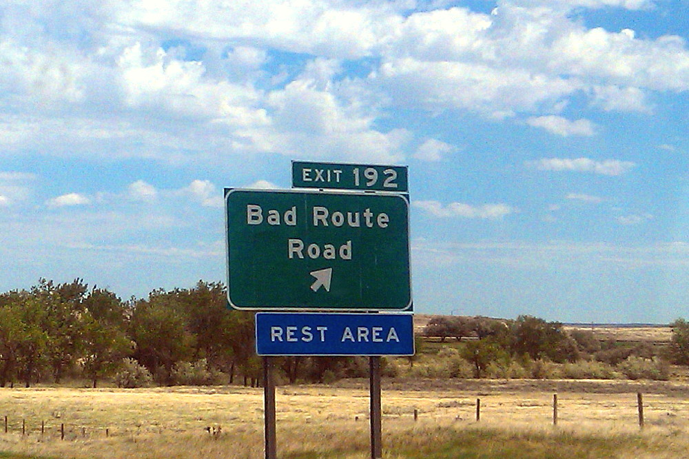
Bad Route

MOH sent this sign picture to me from eastern Montana, the sign being located on the eastbound lane of I-94 (Google Street View). I don't know if he visited the rest stop; other than that possibility, I know he didn't drive down the road to check it out. Bad Route Road may have been named after the nearby Bad Route Creek (which has a Bad Route Creek Bridge, and an East, West, and Middle Fork). There is also a Bad Route School.

As it turns out, this is the same sign that was used in the famous internet meme, "All Your Base are Belong to Us" (known as AYB or AYBABTU). The original shot of the sign, here, was turned into this sign, here.

All Your Base website [dead link].
All Your Base flash video.
All Your Base at Know Your Meme.
All Your Base at Uncyclopedia.
All Your Base video on YouTube:


I recommend watching the flash video, it seems a bit clearer.

The sign, and its partner on the westbound lane of I-94 (Google Street View), is also a bit of a meme in and of itself, having been posted on at least a couple blogs, and mentioned or linked to in threads about strange signs and strange placenames in the U.S. and around the world. Get your Bad Route Road e-card here!

Monday, January 30, 2012

One Year Ago Today: Almost Stuck!

The day was dark with rain and snow, but we headed out anyway, thinking that we could visit the museum in the small town of Cherry Creek in eastern Nevada. We made our first stop on the side of the road to check out this large antelope herd. Antelope can often be spotted between McGill and old Schellbourne Station.
Cherry Creek, the town, is located on the eastern range front of the Cherry Creek Range, where Cherry Creek, the creek, comes out of a small gap in the mountains. Structurally, Cherry Creek looks like it's situated where the north Egan Range runs into the Cherry Creek Range, but the northern end of the Egan Range as named is located in Egan Canyon, the next gap to the south (MSRMaps location showing the regional Basin and Range structure).

That's State Route 489 (above) cutting across Steptoe Valley toward Cherry Creek. The parallel white lines along the road in the center of the valley are patches of snow; standing water can be seen south of the paved road. This possibly intermittent lake or wetlands has recently appeared to be contiguous with Goshute Lake several miles to the north. (This year's so far extra-dry winter might have changed the extent of the southern wetlands.)
This is most of the small community of Cherry Creek. The museum wasn't open, the light was flat and dark, and we didn't spend much time looking around.
It could be a nice place to live, if you like beautiful scenery, out-of-the-way places, and long drives to market.
We hightailed it back to the center of the valley, where we decided to drive south along the historic Nevada Northern Railway to check out a boxcar or other railroad-related artifact we could see off in the distance. The road was well graveled and dry to begin with; the yellow line in the Google Earth image above shows our traverse from the paved road southward.
We made it about 600 or 700 yards before deciding not to go any farther. At this point, the road was turning into a watery mudhole, with no end in sight. In fact, we'd already driven breathlessly and unwittingly through mud we initially couldn't see the end of, and we had come to this short semi-dry spot. The rail, just off to the left in those prickly bushes, prevented any turnaround options, so I decided to back out.
Backing out meant going through a long stretch I shouldn't have driven through in the first place, but had started into before I could stop, then kept going through while hoping for a break in the mud and a turnaround spot. You can see the closest mud hole easily, a second, even larger hole beyond that, and a hidden muddy spot between the two more obvious holes.
Looking at this after driving backwards through it, makes it look pretty tame, but the truck kept getting pulled sideways into the deeper parts of my own tracks, while I tried to stay to the side on the dryer ground right next to the bushes. Consequently, we experienced a bit of fishtailing, and my dual tracks look like a mess of incompetent driving.
Backing up even farther, the road looked good as we went in, just slightly muddy.

Mud is a deceptive thing to try to drive through. Often, one can see a weakly muddy road ambling off in the distance, and this light mud goes on far enough ahead that one can easily get started into what turns suddenly, or gradually, into heavy-duty, very slippery, or deep mud. Getting out and walking an unfamiliar road is recommended, but one usually only walks so far ahead before deciding that the coast is clear: let's go ahead and drive! Incipient or weak mud might suck you in (so to speak), then suddenly, just around the corner: OMG! You're suddenly stuck if you stop, maybe not stuck if you keep going, or maybe staggeringly stuck far from solid ground if you keep going.

If stuck in winter, waiting until the big freeze early in the morning can be one way of getting out. Sometimes a longer waiting period (say months until spring or summer) is required, along with heavy equipment (a D-8 or D-9 dozer). With all the large bushes along our road, we would have been able to build a road under and behind my truck; this procedure often requires multiple jackings-up of the truck (jacking-ups?).

We weren't far from a routinely traveled road, so if badly stuck we could have walked out (in miserable weather) and hoped that whoever we flagged down could have rustled up a dozer: mechanized extraction is easier, though more costly, than building a road by hand. Overall, my getting stuck preferences include better weather (not too hot, not too cold), and I much prefer to be paid to get stuck and unstuck — rather than to be doing it on my own time — a preference come to by many years of off-roading as part of my job.
After backing through the mud, I finally reached a wide point in the road and turned the truck back to the north. An old pump house from the historic Cherry Creek Station is mostly hidden behind the truck; the remains of the water tower can be seen to the right.
We didn't spend much time looking at the base of the water tower at Cherry Creek Station. Maybe we'll go back someday, preferably when the sun is out!