Showing posts with label meme. Show all posts

Tuesday, December 8, 2015

Twelve Months of LFD (2015)

I'm doing the year-end meme wherein I compile the first sentence of the first post of every month. Meme rules are as follows, as per DrugMonkey:
Post the link and first sentence from the first blog entry for each month of the past year.
I've also added the photo from the same first post, if there happened to be one. I've removed any captions from the photos, so if you want to find out more about locations, etc, you'll have to click through. The first sentences include some classically long, LFD-style sentences, one short sentence, and many that are in between. Previous takes on this Twelve Month meme at LFD were posted for 2008, 2009, 20102012, and 2014.

Aaand...here's the year 2015 for LFD:
January:
A year ago today, a thin snow highlighted some Lake Lahontan shorelines on basalt-capped hills out in (or near) the Fernley Wildlife Management Area (FWMA):

February:
Yesterday, when out hiking in nearby Water Canyon (before the Super Bowl), MOH and I slowly (at least for me) made our way up a variably steep, grassy to rocky hillside until we came to a large rib of quartzite.

March:
Well, I'm back at the place I was working at about two years ago (see these three posts for more info), spending more time on a back paved road and on dirt roads than I was most recently while on the road to work (I'm still driving on the interstate some, but a lot less than during the last two years).

April:
It was a very windy day as I drove south along what's variably called the Surprise Valley Road or the Sand Pass Road (and to the north, is often called the Smoke Creek Road) into the Pyramid Lake Paiute Tribe's Reservation.

May:
It is often — more commonly than in the past, IMO — hazy or dusty in north-central Nevada where I routinely work and often travel, here and there across basins and over ranges.

June:
An El NiƱo has supposedly set in (starting when, exactly, I'm not sure).

July: Nada. Zip. Zero.

August:
Neil Young: Rockin' in the Free World (lyricsAlbum: Freedom, 1989
This is technically a road song because it mentions streets twice and roads once, and because the video that came out with the song also shows a lot of streets.

September:
There I was minding my own business while flying north from RNO to SEA (that is to say, I was reading a thick book and trying to ignore a seatmate while crammed against the window near the rear of a Q400), when I looked out (to the east) and spotted the peak of an Oregon volcano sticking out through what I first thought was a low, thick cloud cover.

October:
South of the Klondyke District (our previous stop on this journey) and just north of Goldfield, one reaches one of the northernmost populations of Joshua trees (Yucca brevifolia)—or the northernmost population, depending on what range map you use.

November:
In later years—in the future of the 1976 "present" of these ongoing thesis-hunt stories—I made my way back into the Palmetto-Magruder area barely a handful of times.

December:
When I pulled up to Lida Summit two years ago—I was on my way to a property examination and had decided to check out the Lida and Palmetto areas—I stopped right in front of...a roadcut!

Thursday, December 11, 2014

Twelve Months of LFD 2014

I missed this retrospective meme last year (as I also did in 2011), but here it is, back again, per DrugMonkey:
The rules for this blog meme are quite simple.
-Post the link and first sentence from the first blog entry for each month of the past year. I originally did this meme, after seeing similar posted by Janet Stemwedel and John Lynch. Prior editions include 2012201120102009 and 2008.
Previous takes on this Twelve Month meme at LFD were posted for 2008, 2009, 2010, and 2012. As usual for LFD, I've also added the accompanying first photo of the month, where there was one with the first post of the month, and a gratuitous sign photo for October.

So, here's the year 2014 for LFD:
January:
I'm sitting here inside flight 112--I think--with my phone in airplane mode, wondering if I can create a blog draft that I can save and post later.

February:
We've been having unsettled to stormy weather here in western Nevada for about the last week, with at least light snow accumulating in the mountains, though the south facing slopes have gone back to being mostly bare, even under today's cloudy skies.

March:
Flying back from Alaska on yet another recent trip, I was able to spot Rose Spit, which featured as Where in the West challenge back in October of 2010.

April:
A while back, I started collecting photos of Majuba Hill (AKA Majuba Mountain), partly because I pass by daily on the way to and from work, and also because of it's interesting shape and fascinating geology (which I hope to learn more about on this spring's GSN field trip).

May:
MOH and I will shortly be off on a field trip to a few nearby localities, including Majuba Hill, reportedly a great mineral and rock collecting site, seen here from I-80 looking northwest across Rye Patch Reservoir.

June:
Here are a few photoviews from Majuba Hill, while I get it together to take some rock photos:

July:
A quick report on a canoe trip we took recently:

August:
So, while I wasn't thinking about it, my 1000th post posted, and this is my 1005th! I'm not sure, really, what to say about this — although I'm also sure I'll think of something — other than Yay!!

September:
The sun is about to rise through thick smoke blanketing the
southern Humboldt Range.

October: A colleague of my former (deceased) husband once said, "Archaeologists are the Cowboys of Science."
[He was wrong, btw. Read the post to find out why.]

November:
So there I was, traveling west on I-80 late last week — just after our first rain sans snow (except for at the high elevations of a few mountains east of the Sierra, like the Humboldt and Sonoma Ranges, which top out at 9836 and 9396 feet respectively), and before our most recent larger rain and snowstorm of this past weekend — when I came to the marshes that border the west end of the Fortymile Desert.

December: MOH turned me on to this song just yesterday (I didn't listen to much besides classic rock and country in the 80s).


Sammy Hagar: I Can't Drive 55 (lyrics)
Album: VOA, 1984

Thursday, March 27, 2014

Fieldwork in the US: A Map


Short Geologist over at Accidental Remediation has started a new meme: US states you've done fieldwork in. She has excluded states where she may have only done fieldwork during grad or undergrad school, as have I, but she encourages you to use any definition you'd like when making your own fieldwork map. Additionally, I have left out two countries I've done minimal fieldwork in (I'd have to make a separate map). Some of you might want to make a fieldwork by country map.

I'd add Virginia, Michigan, and Hawaii to this map if I were to expand my definition to include states I've done field work in during my undergrad years (Virginia) along with states I've visited in a geological capacity, though either not for pay (Hawaii) or not doing actual fieldwork but going on field trips or for-pay trips to the field (Hawaii, Michigan).

As you can see, I'm primarily a western geologist. Anyone else want to join?

Wednesday, January 8, 2014

My Travels in 2013 (A Belated Travel Summary)

I apparently haven't participated in the Year of Travel Meme since 2010, possibly because I traveled back and forth across the same old roads in 2011, 2012, and 2013 -- or possibly I was just too busy at the holiday time of year to get that kind of blog post together. This year, Evelyn Mervine got her Year of Travel 2013 post up right at the end of the year; I'm getting mine up before the end of January, 2014. What follows is a brief summary.

January: Returned from a trip to Alaska.
Spruce on snow.
February: Visited Unionville, NV, in scenic Buena Vista Valley, stopping to take a photo of a cabin that purportedly once belonged to Samuel Clemens (Mark Twain).
Old cabin.
March: Visited Leach Hot Spring in Grass Valley, NV, and Kyle Hot Spring in Buena Vista Valley.
Leach Hot Springs.
At Kyle Hot Spring, looking across Buena Vista Valley toward Unionville.
April: Drove within sight of Wheeler Peak in eastern NV.
Wheeler Peak seen from Highway 50.
May: Drove by and contemplated the badlands near Rye Patch Dam several times.
Looking west from I-80 just south of Rye Patch Dam.
June: Drove several parts of old Highway 40 in Nevada, including this one near Humboldt House:
Old 40 looking northeast between Humboldt House and Imlay.
July: Crossed the Humboldt River, drove on the Applegate Trail past Haystack Butte, and visited Sulphur, NV, host to large piles of sulfur and scattered old junk.
Sulfur at Sulphur.
August: August was the month in which MOH and I rapidly toured parts of five western states. I blogged about the trip a little, but not as much as I hoped. Besides places already mentioned, we stopped briefly at the North Rim.
Distant view of the San Francisco volcanic field from the North Rim,
with the cherty Kaibab Limestone in the foreground.
After so much travel in August, I apparently didn't go anywhere until the last day of October.

November: Family matters took me to Alaska, where I took very few non-family-related photos.
Mt. Susitna. A little more about the "Sleeping Lady," as she is often called here,
and a bit about the Sleeping Lady brewpub here.
December: Another trip to points north.
Mt. St. Helens, Spirit Lake, and the Toutle River.
It is, perhaps, a little too late for this post to be considered part of a 2013 travel meme, but if you haven't posted a travel compilation for the year yet, feel free to take my cue and give yourself til the end of January!

Friday, January 18, 2013

I look for and find small to large areas on and under the ground...

I look for and find small to large areas on and under the ground: lands and rocks that have something we want, something that we will mine if we can make enough money.

First, we drive or fly into an area of great promise, so we can put small and large rocks into bags. These rocks in bags are sent away so we can find out what they are made of, so we can see what the numbers will tell us. If we like what the numbers say, then we walk around the area of interest making notes and drawing lines in our field books and on large pieces of paper, and searching, always searching for the right signs. After that, if the signs are good and the numbers from the rocks are even better, we push long, round, empty spaces into the ground and pull out rocks to place in bags or boxes, all so we can continue to find out what the rocks are made of.

After looking at several areas, we eventually find exactly what we are trying to find--rocks that can make us some money (the numbers, some computers, and men and women that study numbers and work with computers tell us how it all came out; they *never* let us just go with our best guess). Then we put in a mine by using picks and other, larger and louder things, to go as deep under the ground as needed. After that, we take the money we made--while finding the good rocks or while working at the mine--to a bar, where we drink out of large glasses or bottles filled with something we like (fill in the ____ ). :-)

Then we go back out into new areas to look for more rocks that can make us some money (or rocks that we at least like, because we all like rocks, except maybe for the men and women who really like numbers and computers).

Permalink for this description of what I do as a mineral exploration geologist at The Up-Goer Five Text Editor.

Meme directive from Ann and Chris at Highly Allochthonous: Go to the Up Goer 5 text editor and explain your research or discipline in the 10 hundred most common words.

Ten Hundred Words of Science: a compilation of many of these descriptions.

Twitter: #upgoerfive #upgoer5

Thursday, December 27, 2012

Twelve Months of LFD (2012)

I missed this retrospective meme last year, but here it is, back again, as per DrugMonkey:
The rules for this blog meme are quite simple.
-Post the link and first sentence from the first blog entry for each month of the past year.
I originally did this meme, after seeing similar posted by Janet Stemwedel and John Lynch.  Prior editions include 201120102009 and 2008.
Previous takes on this Twelve Month meme at LFD were posted for 2008, 2009, and 2010. As usual for LFD, I've also added the accompanying first photo of the month, where there was one with the first post of the month.

January:
I went on my first walk of the year earlier today, out along a creek in Anchorage, AK.

February:
I thought I'd back up to a time a week before our stop at The Geographic Center of Nevada, a time just prior to our soak at Spencer Hot Springs

March:Upon getting out of the truck at the north end of the Monitor Valley playa, it became rapidly clear to me that it was very cold. 

April:
I thought I'd actually have time over my 5-day break to get caught up on some blogging, but that hasn't been the case, and things aren't looking all that great for the coming 8- or 9-day work week and the break following that, so I'm posting a few views from the new area.


May:
Just a quick post showing a photo I took about two weeks ago at 5:50 am, on my early morning ride to work. 

June:
Yesterday I received an email while at work telling me that there was a hummingbird moth in one of our two pots of chocolate mint, which are sitting outside on the front porch. 

July:
These stitched photos were taken about three weeks ago near the site of Preble (just off the map to the west).

August:
These relatively small pinnacles are located in the canyon of Midas Creek, just north of the town of Midas, Nevada.

September:
Besides the obvious greenish feldspar, the countertop rock is composed of black pyroxene, gray metallic minerals (magnetite or ilmenite are likely, but I didn't bring my magnet, magnetometer, or portable xrf), and pyrite.

October:
In the morning after I wake up—while I'm drinking my first, second, and maybe third cup of coffee—I often think of things to write for the blog, how to write them, maybe even what pictures to use.

November:
I got to thinking after taking another looking at my arc photos, that this shot may show a weak tangent arc above the also weak 22 degree halo around the sun.

December:
We came in from the east or north, depending on how you view the direction of I-80 as it traverses the entire north-south length of the west flank of the Humboldt Range from Florida Canyon to Limerick Canyon northeast of Lovelock.

Friday, June 22, 2012

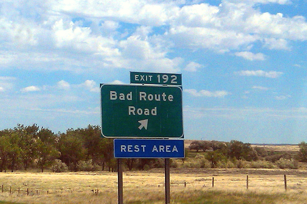
Bad Route

MOH sent this sign picture to me from eastern Montana, the sign being located on the eastbound lane of I-94 (Google Street View). I don't know if he visited the rest stop; other than that possibility, I know he didn't drive down the road to check it out. Bad Route Road may have been named after the nearby Bad Route Creek (which has a Bad Route Creek Bridge, and an East, West, and Middle Fork). There is also a Bad Route School.

As it turns out, this is the same sign that was used in the famous internet meme, "All Your Base are Belong to Us" (known as AYB or AYBABTU). The original shot of the sign, here, was turned into this sign, here.

All Your Base website [dead link].
All Your Base flash video.
All Your Base at Know Your Meme.
All Your Base at Uncyclopedia.
All Your Base video on YouTube:


I recommend watching the flash video, it seems a bit clearer.

The sign, and its partner on the westbound lane of I-94 (Google Street View), is also a bit of a meme in and of itself, having been posted on at least a couple blogs, and mentioned or linked to in threads about strange signs and strange placenames in the U.S. and around the world. Get your Bad Route Road e-card here!

Wednesday, June 20, 2012

American 101 Geo-Sites Meme

Callan Bentley has a new geo-meme up over at Mountain Beltway, based on the book 101 American Geo-Sites You’ve Gotta See, by Albert Dickas. I've bolded the ones on the list that I've seen.

1. Wetumpka Crater, Alabama
2. Exit Glacier, Alaska
3. Antelope Canyon, Arizona
4. Meteor Crater, Arizona
5. Monument Valley, Arizona
6. Prairie Creek Pipe, Arkansas
7. Wallace Creek, California
8. Racetrack Playa, California
9. Devils Postpile, California
10. Rancho La Brea, California
11. El Capitan, California
12. Boulder Flatirons, Colorado
13. Interstate 70 Roadcut, Colorado -- which one??
14. Florissant Fossil Beds, Colorado
15. Dinosaur Trackway, Connecticut
16. Wilmington Blue Rocks, Delaware
17. Devil’s Millhopper, Florida
18. Stone Mountain, Georgia
19. Kilauea Volcano, Hawaii
20. Borah Peak, Idaho - I've driven by, anyway
21. Menan Buttes, Idaho
22. Great Rift, Idaho
23. Valmeyer Anticline, Illinois
24. Hanging Rock Klint, Indiana
25. Fort Dodge Gypsum, Iowa
26. Monument Rocks, Kansas
27. Ohio Black Shale, Kentucky
28. Mammoth Cave, Kentucky
29. Four Corners Roadcut, Kentucky
30. Avery Island, Louisiana
31. Schoodic Point, Maine
32. Calvert Cliffs, Maryland
33. Purgatory Chasm, Massachusetts
34. Nonesuch Potholes, Michigan
35. Quincy Mine, Michigan
36. Grand River Ledges, Michigan
37. Sioux Quartzite, Minnesota
38. Thomson Dikes, Minnesota
39. Soudan Mine, Minnesota
40. Petrified Forest, Mississippi
41. Elephant Rocks, Missouri
42. Grassy Mountain Nonconformity, Missouri
43. Chief Mountain, Montana
44. Madison Slide, Montana
45. Butte Pluton, Montana
46. Quad Creek Quartzite, Montana
47. Ashfall Fossil Beds, Nebraska
48. Scotts Bluff, Nebraska
49. Crow Creek Marlstone, Nebraska
50. Sand Mountain, Nevada
51. Great Unconformity, Nevada -- have seen this in Grand Canyon, AZ
52. Flume Gorge, New Hampshire
53. Palisades Sill, New Jersey
54. White Sands, New Mexico
55. Carlsbad Caverns, New Mexico
56. Shiprock Peak, New Mexico
57. State Line Outcrop, New Mexico
58. American Falls, New York -- have seen American Falls, ID (ha!)
59. Taconic Unconformity, New York
60. Gilboa Forest, New York
61. Pilot Mountain, North Carolina
62. South Killdeer Mountain, North Dakota
63. Hueston Woods, Ohio
64. Big Rock, Ohio
65. Kelleys Island, Ohio
66. Interstate 35 Roadcut, Oklahoma
67. Mount Mazama, Oregon
68. Lava River Cave, Oregon -- other tubes, other places
69. Drake’s Folly, Pennsylvania
70. Hickory Run, Pennsylvania
71. Delaware Water Gap, Pennsylvania -- other water gaps
72. Beavertail Point, Rhode Island
73. Crowburg Basin, South Carolina
74. Mount Rushmore, South Dakota -- if I can't remember, does it count?
75. Mammoth Site, South Dakota
76. Pinnacles Overlook, South Dakota
77. Reelfoot Scarp, Tennessee
78. Enchanted Rock, Texas
79. Capitan Reef, Texas
80. Paluxy River Tracks, Texas
81. Upheaval Dome, Utah
82. Checkerboard Mesa, Utah
83. San Juan Goosenecks, Utah
84. Salina Canyon Unconformity, Utah
85. Bingham Stock, Utah
86. Whipstock Hill, Vermont
87. Great Falls, Virginia
88. Natural Bridge, Virginia
89. Millbrig Ashfall, Virginia
90. Catoctin Greenstone, Virginia
91. Mount St. Helens, Washington
92. Dry Falls, Washington
93. Seneca Rocks, West Virginia
94. Roche-A-Cri Mound, Wisconsin
95. Van Hise Rock, Wisconsin
96. Amnicon Falls, Wisconsin
97. Green River, Wyoming -- and Flaming Gorge, etc.
98. Devils Tower, Wyoming
99. Fossil Butte, Wyoming
100. Steamboat Geyser, Wyoming
101. Specimen Ridge, Wyoming

I've only got 24, with huge gaps in the east, central, and northern states.

Should be listed: Neguanee Iron Formation, MI.
Only one for AK?!

Saturday, February 4, 2012

Top 10 reasons I love detachment faults / core complexes

Not sure about the order of these things, but here's a go at the geoblogosphere's most recent spontaneous meme, as started by Erik Klemetti, and followed by Siim Sepp and Callan Bentley. Oh, and by the way, I also love volcanoes, sand, and structure — among other geologic subjects and subdivisions — not necessarily in that order.

* They are not everywhere. Detachment faults associated with metamorphic core complexes are generally found in a band running from British Columbia, into Washington and Idaho, through eastern Nevada, into Arizona and the Mojave Desert of California, and down into Mexico (and also in other parts of the western U.S. and in other parts of the world). They run through my general neck of the woods, in other words, but occur in rather specialized geologic settings. This is all right by me. (If they were everywhere, we would miss out on other types of geology.)

* Detachment faults are found in Nevada. I love working in Nevada! Has anyone noticed that?

* Detachment faults and core complexes are found in the Mojave Desert. At first I kind of disliked working in the Mojave Desert because, although similar to Nevada in some ways, it isn't Nevada: it's hotter than Nevada, it's dustier and hazier than Nevada, and the mountain ranges are often older, more worn down, and farther apart than those in Nevada. The roads are cruddier, the small towns less inviting or pleasant in many ways (e. g. Baker, CA). You can find some strange people in the Mojave, and the place doesn't seem as safe as Nevada. I gradually grew to like the Mojave Desert, maybe largely for the exceptional geologic exposure, maybe for all it's weirdnesses, maybe because someday, perhaps, Nevada will look more like the Mojave. I also love to hate cholla cactuses, especially ones growing around the Whipple Mountains core complex.

* Detachment faults are often well exposed. Good exposure of detachment faults is, perhaps, largely associated with their general location in areas that have good exposure, but being of regional extent by definition, they consist of large faults that can often be found around or on top of entire mountain ranges. (I love exposure.)

* A good detachment fault is a thing of beauty. It's relatively flat-lying, very smooth, often shiny, and has wonderful slickenlines and grooves all over it's surface, often aligned in a nearly east-west direction.

* A core complex is complex (surprise). Core complexes aren't easy to understand, and every one seems a bit different from it's nearest neighbor. Geologists dispute the formation and development of these things, allowing for great arguments over beers, great field trips and arm-waving sessions, and exceptional reason for practising down-to-earth to wild-eyed geo-speculation.

* Core complexes and detachment terrane in general are good places to study all kinds of geology. I love all kinds of geology for all kinds of reasons. You can find all rock types — sedimentary, metamorphic, and igneous (often plutonic, sometimes volcanic) — associated with core complexes and detachment terrane, along with great structure.

* Core complexes are mega structural features. I love structural geology, and core complexes and associated detachment faults provide excellent terrain for studying all kinds of structure, from mega to micro scales, including often unexpected but sometimes present contractional structural features.

* Detachment faults are a good place to find breccias: microbreccia, chlorite breccia, etc. I love breccias!

* Core complexes can contain ore deposits. Sometimes older ore deposits have been smeared or extended in the lower plate below the detachment fault; sometimes ore deposits are found along the detachment fault in possibly genetic association; sometimes pre-detachment ore deposits have been extremely sliced and diced by the detachment fault and its related upper-plate faults. Exploration for ore deposits is what I do. (Read a few discovery stories here.)

Sunday, November 20, 2011

Sand Mountain for Sand Dune Week

Two dune posts in a row in a row creates a geoblogosphere meme, and Sand Dune Week has been proclaimed!
Sand Mountain — located on Highway 50 about 25 miles east of Fallon, NV — is a perfect candidate for Dune Week, being one of those booming or singing dunes described here on Cocktail Party Physics.

View angle, time of year and day (sun angle), and weather all affect the seemingly shifting appearance of Sand Mountain, sometimes dramatically. The first photo (above)was taken from the west-southwest during the middle of an early March day last spring, 2011.
This second photo was taken from the south in the late afternoon in late May, also 2011. Enlargement of the second photo will reveal a barely visible white line on the east side of the dune: the RV city usually sitting in the lee of the dune, where ATVers gather to run up and and down the face.
Here's the mountain in a wind storm, a late afternoon in mid-May of 2009. Any RVs present are getting sand blasted!
Lighting for pictures can be quite variable, and I often get flat pictures just driving by at random times of the day. But even mid-summer can be good for shadows and details, as shown by this photo taken early one morning in early July, 2010. Enlargement of this photo shows two tiny-looking ATVs on the west side (far left) of the dune, behind and a little to the right of a foreground dark spot that is possibly a rock or large bush. Look carefully!

Although I've driven up to the RV city and to the half buried Sand Springs Pony Express station, I've never gone on the dune to try to make it boom.

One thing that can be done fairly easily, as part of this mini virtual field trip, is to follow the sand from Sand Mountain back to its original source, back to the southwest across a mountain or two, then across Highway 95 south of Fallon, southwest toward the delta of the Walker River, where the river emptied into ancient Lake Lahontan. Start with this map and this air photo, then go here (scale change), then here, and then here (direction change). The last air photo is mostly below the high stand of Lake Lahontan, but shows the final current destination of the Walker River: Walker Lake.

Meme participants so far:
Galileo's Pendulum
Clastic Detritus
Cocktail Party Physics
In the Company of Plants and Rocks
Agile* - Journal
Ron Schott's Geology Home Companion Blog
Research at a snail's pace
Earth Science Picture of the Day
Sandatlas
Georneys
Pools and Riffles
Earth-like Planet
En Tequila Es Verdad
Through The Sandglass
EarthSky // Blogs // Space (Deborah Byrd)

Some References:
La Pointe, D.D., 2000, Earth Science Week 2000: Geology along America's Loneliest Highway. A field trip for families and rockhounds: Nevada Bureau of Mines and Geology Educational Series E-37.

Trexler, D.T., and Melhorn, W.N., 1986, Singing and Booming Sand Dunes of California and Nevada: California Geology, v. 39, no. 7, p. 147-152. Also reprinted here on Tom Sweich's webpages.

NOTE: The California Geology search page is quite finicky or counterintuitive. I finally searched using only the year, 1986. What also worked was %California% %Nevada% with the percent symbols, entered as keywords under "Title of Article."

Wednesday, October 12, 2011

An Evil Geologist Lair

I've been thinking about the ideal location for my own personal evil geologist lair (in case I develop any evil tendencies in the near or far future), and realized, with great sadness, that now that Mt. Shasta has already been taken by Garry Hayes, and because the best beach is already occupied by Jessica Ball, that I'd have to look somewhere else besides volcanoes.

In fact, the only fitting possibilities would be something like a really deep, scary, haunted, open pit like the one in Desperation (Stephen King's novel, Stephen King's film), or (more likely) a nice pleasant underground mine hidden away somewhere in the desert outback, left to me and me alone by the old-timers that dug the mine. One in particular pops into my mind, the Mary-Drinkwater Mine, on Mineral Ridge above Silver Peak, Nevada. Unfortunately, however, that mine, which had beaucoups levels dug into en echelon, low-angle quartz veins, is probably not the same after undergoing open pit mining. So, I'll have to choose another place. (I know where, but ain't tellin'.)

A good underground mine will be in a location not known to anyone else, so I can get away when needed and not be found when being searched out by whomever might be doing the searching (black helicopters have been suggested). It will therefore not only be in an obscure location, but its opening — a typical adit into some hillside either somewhere in Nevada, the Mojave Desert of California, or Idaho (don't ask me why the latter) — while looking like any other adit if you happen to be passing by on the surface, will be absolutely hidden from view from overhead. In fact, it will have multiple openings, as all underground mines should. The main adit opening will look rather uninviting to casual passersby, including most geologists, and would only possibly be entered by the most dedicated of exploration geologists seeking out gold or quartz or hidden structures.

A second opening, way back into the hillside, will provide good ventilation (an air shaft), and will probably be so hidden on the hillside above that not even a scurrying-by pocket monkey or prairie dog will see it.

A third opening will be down a side tunnel, through an open stope that shows indications of incipient caving toward the left, so that most people in the know (underground miners, desert rats, exploration geos) will either avoid the room entirely or will at least skirt it far to the right, where booby traps can be set and sprung if needed. This open stope, once negotiated correctly, will lead into some drifts in solid quartz. Multiple levels will open up from this point, with elevators going up and down between levels, following the old, originally hand dug and now widened, raises. A back exit, only obvious with some digging around and following of anomalous air flows, will allow escape through an active underground mine on the other side of the mountain, where I will be able to exit surreptitiously with all the other miners at shift change.

A fourth opening, the entrance of which will be partially caved so as to look uninviting, will lead past a caved open stope to a hallway of gold-bearing quartz that will impede the approach of even the most dedicated gold-seekers (they will have to stop for samples and won't pass further without taking their sample bags out to a typical mineral exploration pickup, thereby allowing time for any evil denizens of the deep who happen to be present to escape deeper into the mine). Beyond the wall of gold-bearing quartz, a flat-lying metal grizzly made of old mine rail will bar access to the last escape route. If anyone makes it this far into the deeps of the lair, they will not know to press a button inside a panel hidden behind the pile of slabbed, broken waste rock sitting nearby. In fact, they will ignore the waste rock entirely and go for the ore sitting next to the grizzly, large chunks of gold-quartz ore that the old-timers left because it didn't fit through the grizzly.
Meanwhile, the denizen of the lair (that would be me), will be running down the haulage tunnel below the grizzly, heading for its opening in the wash right above the old, hand-built road, an opening now obscured by decades of flash flooding down a steepening canyon. The ATV awaiting me at this exit, will allow me to pass nearly unseen and certainly camouflaged by ordinariness, down the mountain to The Alternative bar, where I will blend in with miners and geologists alike.

One view from a good lair.