Showing posts with label canada. Show all posts

Friday, March 7, 2014

A Where in the West Revisited: Rose Spit, B.C.

Flying back from Alaska on yet another recent trip, I was able to spot Rose Spit, which featured as a Where in the West challenge back in October of 2010. The shape of the northeastern tip of Graham Island — an island in the Haida Gwaii, or Queen Charlotte Islands, off of the coast of British Columbia up near Prince Rupert — always fascinates me.
The northern portion of Graham Island, with Rose Spit on the left below the wing, and Maset Sound in the upper right.
Maset Sound is a narrow, river-like entrance into the larger, saltwater body of water known as Maslet Inlet, which is somewhat visible beneath the clouds hovering over the central part of the island.
The waves around the spit were reflecting in a bright, yellowish glare from the mid-day sun.
A closer view of the convoluted shape of Rose Spit and its associated small islands.
A view of the spit, with a few of the small islands off its tip.
Related Posts:
Where in the West: October 2010
Where in the West: Rose Spit, B.C., Canada

Friday, January 10, 2014

Where in the West: Dean and Burke Channels; Thunder Mountain and Tzeetsaytsul Peak, B.C.

Dean Channel on the left, Burke Channel on the right.
The January 2013 Where in the West was won by Ron Schott, not only for finding the names of the two major fjords shown in this photo, but also for identifying the mountain near the head of Burke Channel, which has two major peaks: Thunder Mountain, the highest, and Tzeetsaytsul Peak, somewhat lower. Ron also came up with the name of northern branch of Burke Channel, known as North Bentinck Arm.

I didn't know the location of this challenge when I posted it, but having seen it from the air, I knew it was between Anchorage and Seattle, that it was south of a more-or-less north-south-trending strait, and that it was much closer to Seattle than Anchorage and probably south of SE Alaska. This general knowledge gave me an advantage over anyone else trying to discover the location. I homed in on the location and found most of the names of the fjords and mountains on Google Earth (in labeled photos), but wasn't sure if the names were correct, so checked them on Wikipedia and GeoBC.
Google Earth image almost identical to my first photo. Dean Channel is on the left; Burke Channel is on the right.
It's true that the snow and clouds in the photos I shot complicated finding the location!
A photo zoomed in on Burke Channel.
Google Earth image with Burke Channel centered,
similar to the previous photo. 
Labouchere Channel splits to the left (north), connecting Burke and Dean Channels; the North Bentinck Arm heads straight away from us; and South Bentinck Arm goes off southward, barely visible in this view.
Zoomed in photo with the mountain in question in the distance.
It was  a little harder to get the right angle on Google Earth to zoom in on and identify the mountain that stood out in my view from the airplane, and it was hard from the photo to tell which side of the Burke Channel and North Bentinck Arm the mountain really was on.
Google Earth view, with the North Bentinck Arm of Burke Channel on the left and the South Bentinck Arm heading southward to the right.
The mountain really stands out in the Google Earth view (above). It's really on the north (left) side of North Bentinck Arm, and it has three smaller mountains nearly centered in front of it (west of it).
Google Earth image: Thunder Mountain is the highest peak in the center; Tzeetsaytsul Peak is the next highest peak to the left (north).
And there we have it: several fjords carved by glaciers, now partly (mostly) inundated with water, and one mountain with two main peaks. Thunder Mountain is highest at 2664 m (8740 ft); Tzeetsaytsul Peak comes in at 2575 m (8448 ft). Apparently, both Thunder Mountain and Tzeetsaytsul Peak were named for the thundering sound created by the movement of Tzeetsaytsul glacier.
Google Earth view of Tzeetsaytsul Glacier on the east side of Tzeetsaytsul Peak and Thunder Mountain; north is to the right.
Read about the Bella Coola area (Bella Coola is at the head of North Bentinck Arm) at the Bella Coola Blog.

A few Geological References:
Gehrels, George E., and Nevine D. Boghossian, 2000, Reconnaissance geology and U-Pb geochronology of the west flank of the Coast Mountains between Bella Coola and Prince Rupert, coastal British Columbia: Geological Soc America, Special Papers, v. 343, p. 61-76. Abstract at Refdoc.fr.

Mahoney, J. B., et al, 2002, Structural geology of eastern Bella Coola map area, southwest British Columbia: Geological Survey of Canada, Current Research, 2002-A10, 9 p.

Smith, D. J., and Desloges, J. R., 2000, Little Ice Age history of Tzeetsaytsul Glacier, Tweedsmuir Provincial Park, British Columbia: GĂ©ographie physique et Quaternaire, v. 54, no. 2, p. 135-141.

Stowell, Harold Hilton, and William C. MacClelland, eds., 2000, Tectonics of the Coast Mountains, Southeastern Alaska and British Columbia: Geological Society of America, Special Papers v. 343, 389 p.

A few Geographical Links:
Dean Channel location - at GeoBC

Fitz Hugh Sound - Wikipedia

Fitz Hugh sound location - at GeoBC

Labouchere Channel location - at GeoBC

North Bentinck Arm location - at GeoBC

South Bentinck Arm location - at GeoBC

Thunder Mountain location - at GeoBC

Tzeetsaytsul Peak location - at GeoBC

Saturday, October 29, 2011

Alcan Geology Series

My two posts on Folded Mountain are perpetually popular, at least from searches, so I've put together this mini-series of roadside geology along the Alcan, or Alaska Highway, or Highway 97 (British Columbia). If I knew more about the geology along that road, I might post more of my photos from my several trips.

Alcan Geology and Related Posts:
Where on (Google) Earth #158
Folded Mountain, B. C.
Folded Mountain, B. C. - A Reprise
Muncho Lake, B. C.
More Muncho
Some Alcan Mileage Links

I also have two more posts about Canada, with some introductory or basic geology:
     Where in the West: October 2010
     Where in the West: Rose Spit, B.C., Canada

Thursday, December 23, 2010

Some Alcan Mileage Links

While we're experiencing being semi-snowed in, I'm going to post a few Alcan links, in case any of you have been thinking about driving that highway this winter. (I've been thinking of it, but decided that I don't have enough time right now.)

Alaska Highway - at Wikipedia

Alaska Highway or Alcan? - some history

Alaska Highway 97 - towns and more info at BritishColumbia.com

Alaska Highway Road Log - road log by miles and kilos

Bell's Travel Guides: Alaska Highway - another road log

MilebyMile.com - photos along the Alaska Highway

Friday, December 10, 2010

Twelve Months of LFD (2010)

As per usual (see 2008 and 2009), I'm doing the year-end meme showing the first sentence of the first post of every month, along with - for LFD - the first photo if there happened to be one. Seen everywhere, especially at VWXYNot?, Dreams and hopes of a (former post doc) scientist, There and (hopefully) back again, and Thus Spake Zuska. The rules for this meme are simple, as explained by DrugMonkey: Post the link and first sentence from the first blog entry for each month of the past year.

January
It being the start of a new year (the year 2010 to be precise), I have a few deep-time links for all you deep-time lovers (or would that be lovers of Deep Time?):
February
Here, in non-chronological order, are a few of the geoblogospheric posts that have caught my eye recently.

March
The March, 2010, version of Where in the West (WITW) is really just an excuse to post a glacier picture or two.

April
Just a quick preview of a roadcut on Highway 36 near Susanville, CA, showing a basalt flow over some white [probably tuffaceous] lake sediments. The reddish baked zone may might include subaerial deposits.

May
Callan Bentley at Mountain Beltway has had a couple posts up recently about mud cracks.

June
Three years ago today, while driving between somewhere and somewhere else, I came upon this cool oasis in the greasewood zone below the sagebrush steppe on the northeast side of Honey Lake, CA.

July
waterI took a road trip last week, south into Big Smoky Valley (MSRMaps), in order to grab a few photos from areas I visited in 1976 while on my thesis hunt.

August
I just returned from a mega-trip with MOH into central Oregon, where I met with family at an annual reunion-type affair on a basalt-capped bluff overlooking a small Oregon town.

September
I've been working on a Highway 50 roadside geology series for quite a long time, and have managed to get a few posts in every now and then, but have many more to go before I really consider it complete (could it ever be complete?).

October
Where in the West, if you might remember, features some [unknown] location in the western part of the northern hemisphere.

November
Ophir and Out ... well, to Middlegate, anyway.

December
And so, following on from the post "What is a Road Song," here is the essence of one of the three road tapes I made in the late 1980s.

Everyone who blogs is tagged for this meme.

Friday, October 8, 2010

Where in the West: Rose Spit, B.C., Canada

Rose Spit, with North Beach to the right and East Beach to the left.

The October Where in the West location was won by Ron Schott (no Schott rule was invoked) for finding Rose Spit, which forms the northeasternmost tip of Graham Island in the Queen Charlotte Islands of British Columbia, Canada, about 35 km NE of Massett. The area can be viewed anytime the weather is clear and anytime one happens to get on the wrong side of the plane from Anchorage to Seattle (the right or west side), which MOH and I did about a year and a half ago, while returning from the start of the Iditarod.
The linear, north-trending East Beach in the foreground, with North Beach's beach ridges beyond and to the west.

Howard won the geology portion of WITW by noting the beach, spit, beach ridges, salt marshes or brackish lagoons between the beach ridges. I can't swear to the nature of the water between the beach ridges, but brackish to salty seems likely. Howard raised the question of whether the beach ridges are actually cheniers, which are beach ridges deposited on tidal mud flats or "on an alluvial plain of silt, clay, or peat on prograding deltas or coastal plains." I haven't found any information about what the sand ridges at Rose Spit are deposited on, so will have to go with beach ridge for now.
Also seen at Rose Spit:
"dissipative beaches backed by prograding foredunes on North Beach; reflective cuspate cobble beaches with a sandy low tide terrace on NW Rose Spit; and multiple-barred beaches backed by migrating foredunes and parabolic dunes on East Beach."
Pictures of these features — and much, much more — can be seen here, on page 3 and 4 of the pdf.

And from Overview of Geologic Hazards to Offshore Petroleum Development – British Columbia Continental Shelf:
"Megaripples, sand waves and sand ridges are particularly important in the vicinity of Rose Spit and Rose Bar at the northeast corner of Dogfish Bank. These features are the result of storm-driven sand motion on the shelf under the influence of topographic steering of tidal and wind-driven currents. In this area amplitudes of the sand waves and sand ridges can exceed 6 m. "
"The eastern coastline of Graham Island is largely dominated by a thick sequence of unconsolidated glacial outwash deposits capped locally by Holocene dunes. These sediments are retreating rapidly, with the eroded sediments being swept northwards towards Rose Spit. While average erosion rates apear to be about 1 m per year, retreat is highly episodic; in 1992-1993, for example, 11 m of land was lost at Cape Fife and 1.5 m was lost in a 24-hour period at the same site in 1994. Numerous, ephemeral shore-attached bars are associated with the high rates of longshore drift along eastern Graham Island. "
View Rose Spit at Flash Earth.

Some References:
Bornhold, B., and Harper, J., 2002, Overview of Geologic Hazards to Offshore Petroleum Development - British Columbia Continental Shelf, in BC Offshore Hydrocarbon Development, Report of the Scientific Review Panel (January 2002), Appendix 11.

Otvos, E., 2005, Cheniers, in M. Schwartz (Ed.), Encyclopedia of Coastal Science: Springer, p. 233-235.

Walker, I.J., and Barrie, J.V., 2006, Geomorphology and sea-level rise on one of Canada’s most ‘sensitive’ coasts: Northeast Graham Island, British Columbia: Journal of Coastal Research, SI 39.

Friday, October 1, 2010

Where in the West: October 2010

Where in the West, if you might remember, features some location in the western part of the northern hemisphere. This time, the unknown area includes water - a fair amount - mostly likely ruling out Nevada and any other intermountain state! Both photos, taken from an airplane, will enlarge somewhat.
Where is this place, and what are some of the landforms?

I'll be out of town over the weekend, will check in via mobile when possible, but I might not be able to respond until Monday or so.

Saturday, January 16, 2010

More Muncho

I'm planning to clear out a few draft posts from last year, and also to hopefully finish up some mini-series. I'm starting by taking a leap back to the dark ages of 2009 - February, that is. I had nearly completed a series I started about the northern Canadian Rockies, centered around Folded Mountain and Muncho Lake. I'm going back there again, this time to a location on the Alcan Highway about 7 miles or 11 km south of the south end of Muncho Lake: the pullout at Mile 426/km 686, Alcan mileage (current mileage). I think this is the "Sawteeth" pullout, which has a sign that may or may not explain the geology of the Sentinel Mountains. I can't actually follow the explanation, so I won't show you the sign! (I mean, it doesn't make any sense to me.)

This oblique southeasterly view of the Sentinel Mountains from Google Earth shows the general area from a little higher than roadside level; that's the Alcan, AKA Highway 97. The topography of the same area, looking straight down and with the north arrow cocked to the right, can be seen here in The Atlas of Canada.
The picture I took looks like this; it corresponds with the two central peaks from the Google Earth image, with just a little of the pyramidal-shaped range-front hill on the far left.
Drawing on a composite set of photos, I came up with this pen-and-ink interpretation, which shows the general flat-lying nature of the sedimentary horizons away from the range front and to the east. The beds are then tilted into a dip slope right along the range front, forming a set of triangular-shaped facets, which I described more completely earlier. If you look carefully at the photo and the sketch, you'll see that they match up imperfectly - the sketch makes the farther hill appear a little larger than life. It is a cartoon.

The Folded Mountain and Muncho Lake Series:

You'll find references, in-post links, more photos and images, and more about the Alcan and general geology in the previous posts.

Wednesday, February 18, 2009

Muncho Lake, B. C.

lake1

Muncho Lake, a scanned postcard version.

Continue to the west and then north on the Alcan, beyond Folded Mountain. After stopping to view Stone Sheep (or Stone's sheep - Ovis dalli stonei) in the highway (a common site), you will come to Muncho Lake, about 36 km from the Folded Mountain turnout. Just so you remember where you started from and have some idea of where you're going, in this topo map, Folded Mountain is in the lower right, just to the left of the Nonda Creek label; Muncho Lake is prominent toward the upper left.

Muncho Lake is pictured above in a scanned version of a postcard I bought somewhere, somewhen on one of my Alaska Highway travels. Again, as in one image in my last post, the postcard seems to have been taken from a hovercraft or airplane; it looks northward.

The light-colored mountainous area, seen to the right (east) of Muncho Lake, is the Sentinel Range, part of the northern Canadian Rocky Mountains. The range continues a little to the north, just out of the postcard picture. I think it ends to the south at the Toad River and the Alaska Highway, although the geology and structure making up the Sentinel Range continues southward beyond the ToadRiver-road line of demarcation.
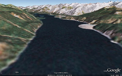
lake2 Above, I've more or less duplicated the postcard view of Muncho Lake with an image from Google Earth. We will be zooming in on a portion of the range front below, in a Google Earth view looking north from a height of about 472 ft (144 m) above ground level (I forgot to switch to meters in my new Google Earth version 5 right away!). The closeup focuses in on the third of several triangular-shaped mountain faces above, and it shows most of the second face in the foreground and part of the fourth face (and beyond) in the background.
range-img These triangular-shaped range faces are dip slopes, with the carbonate beds dipping almost entirely parallel to the faces. These shapes could be called triangular facets, though they are not strictly fault-caused - nor are they the result of truncated spurs - and they are reminiscent of the flatirons along the Rocky Mountain range front in Boulder, CO, though bedding there dips eastward, and bedding above dips westward. Locally, these shapes in the Sentinel Range are called sawteeth. [If there is a better geomorphic or descriptive term for these triangular shapes than what I've used here, I wouldn't mind some input!]
range-pic This photo, taken in 1996 from the north end of Muncho Lake, duplicates the Google Earth image above (or the other way around), and shows the beds dipping parallel to the range front slope. The drawing below highlights the bedding.
range-sketch So, from Folded Mountain, here, we've gone to this northern end of Muncho Lake, here, and are centered in on the triangular part of the range front at the very north end of the lake, here.

Tuesday, February 17, 2009

Folded Mountain, B. C. - A Reprise

Back to our semi-regularly scheduled program, as erratic in content as it sometimes is...
image1 Just pretend that you are still on the Alcan, in that in-between place between Toad River and Muncho Lake in northern British Columbia, Canada. You've just driven to the famed Folded Mountain turnout, pulled out to read the sign, and are now looking at Folded Mountain. If you look to the north, you'll see views like the two I've so cleverly created from Google Earth: the first one, above, looking north from about 450 m above the ground; the second one, below, looking north from just as close to ground level as I could get Google Earth to go, 60 m above the ground.
image2 I don't usually have a hovercraft with me while driving the Alcan, so I usually look at things from ground level, having never spent enough time on the highway to do any hiking around. A hovercraft could, however, be a useful thing to have on this supposedly paved highway: it always seems like major - I mean major - road construction is in progress somewhere along the way. Too bad I don't have photos of some of the boulder fields I've driven through on the supposedly paved highway.
folds Suprisingly, a 1993 photo taken from or near the Folded Mountain turnout looks very similar to the second Google Earth image, but in the photo you can actually see some of the folds. And someone has drawn on the photo, approximately outlining some of the folds. Please ignore the pen lines on the upper part of the mountain - that part is too obscure for drawing to be of any use whatsoever - without having the actual mountain handy (which it's not).

Soon, we'll move just a little farther along the road to Muncho Lake, but first I must take a break. Farther up the road, my drawings will become a little more sophisticated. (But not because of the break!)

Tuesday, February 10, 2009

Folded Mountain, B. C.

My familiarity with Folded Mountain, most recently known as WoGE #158, is from several trips up and down the Alcan, or Alaska Highway, or Highway 97 (British Columbia): four trips through the Fort Nelson to Liard Hot Springs area, two each way.
toad And here, above, is the greater Fort Nelson to Liard Hot Springs region of British Columbia, Canada. Liard River is a tiny community at Mile 496 (HM) of the Alaska Highway; Liard Hot Springs, aka Liard River Hot Springs, is at Mile 497 (HM). I note the location of the hot springs on the image above - rather than that of Liard River - well, because the springs are a great place for a soak if you happen to be passing through.

Muncho Lake
is a lake inside Muncho Lake Provincial Park at Mile 456 (HM) - the lake actually takes up quite a bit of north-south mileage along the highway, but mileage is traditionally taken from a particular historic refueling stop. Toad River is a town, at Mile 422 (HM) on the Alaska Highway; The Poplars at Mile 426 (HM) is a nice place to stay, with large logs making up rustic cabins (late 1990's info). HM = historical milepost; actual miles and kilometers have changed with road changes.
munchoZooming in a bit above, we can see our particular area of interest better: Muncho Lake, the NNW-trending Sentinel Range of the northern Rocky Mountains, and Folded Mountain (link to topography provided by Ron Schott).
mtn1 Here's the Google Earth shot I considered using for WoGE #158. It's an image looking west, from one point on the highway where one can stop and take a photo.
mtn2 And this is what that image would look like at near ground level, just about what you would see while driving west on the Alcan.
pic1 A photo! Now we can begin to see why it is, at least locally, called Folded Mountain.
pic2 Folds!
pic3 Close-up of the same folds!
fold And closer still, from a postcard I probably bought back in 1998 at The Poplars.
signThis is the sign at the Folded Mountain turnout, right at the eastern base of the mountain, at mile 409/km 658 (current mile/km):
Originally, all the rock of the British Columbia Canadian Rockies lay flat on the shallow sea bed of the western continental shelf where it had accumulated grain by grain over a billion years. About 175 million years ago the continent of North America began to move westward, overriding the Pacific shore and colliding with the offshore chain of islands. The continental shelf was caught in the squeeze. The flat layers slowly buckled into folds like those you see here. As time passed, folded mountain ranges sprang up across British Columbia. By 120 million years ago, the Rockies were showing above the sea. They grew for another 75 million years, rising faster than erosion could tear them down - likely reaching Himalayan heights. Active mountain building ended in the Canadian Rockies some 45 million years ago. The peaks have since been eroded to a small fraction of their original size.
Additional and more detailed geological information can be found in the comments of my WoGE #158 post.

Some Geological References:

Friday, February 6, 2009

Where on (Google) Earth #158

Click Image to Enlarge

I just won my second Where on (Google) Earth, yesterday, from Dave Schumaker at Geology News - his first time to win!! - after he posted Mt. Ruapehu, New Zealand for WoGE#157. A second win, a second volcano!!

That means I get to post the #158 edition of this fine game. I think I got lucky: 1) I was online when #157 was posted, 2) for some reason I thought the place looked familiar, although I'm really not sure why, and 3) so I was convinced I could find it! I recognized it as a volcano, and so first looked in all the usual places (the Cascades, for example), and then I wondered... Dave said it was one of his favorite areas; so I looked, and sure enough, he had posted about the volcano back in 2007: I found it first on his website! I think it looked familiar because of the beige silty ash color of the mountain, or maybe it was the crater lake...

To win this game, be the first to find and the first to post the correct latitude and longitude of the above unknown area in the comments, and also describe as much of the geology of the area as you can. I'd be greatly pleased if you could name the closest mountain, which is in the center right above the tiny Image (c) 2009 TerraMetrics lettering. If you win, you get to host the next WoGE on your blog. (Non-blog winners have a chance of hosting right here!)

I am invoking the Schott Rule this time, which means that former winners have to wait exactly one hour per win before posting their answers. Former winners and former locations can be found here. Post time will be 5:00 pm Pacific Standard Time, GMT-8.

Thursday, July 31, 2008

Trilobite for Sale

ReBecca at Dinochick Blogs has already pointed this one out, but being a consummate trilobite lover, I just had to pass this on to anyone who might have missed her excellent post.

Besides being able to purchase a neat, colorful trilobite - for play, for teaching, or for decorating one's house or improving upon one's otherwise dull-looking collection of rocks and minerals - you can get a collection that includes replicas of 500 million-year-old animals of the Burgess Shale from the Royal Ontario Museum online. (The trilobite comes with the collection - see ReBecca's photos replete with scale bars, like this one, or go to the ROM webpage directly for your purchase.)

Trilobite for sale or rent
Olenoides makes a nice present.
Burgess Shale toys all around,
That's as much as I will propound...

Monday, June 23, 2008

Mining and Exploration News

Just a few summaries and links to mining and exploration stories out recently. Excuse some dorky titles. How can you tell which titles are dorky? Easy, the dorky ones are mine.


From Ron Schott's Geology Picks:
Not so Good Oil and Gas Exploration in Washington state

From Geology.com:
Surprise, surprise, there's a new gold rush in CA!
Internet Addiction - do YOU suffer from it? (Oops - not mining related unless you are reading this blog post over and over again!)

Also from Geology.com:
Geologists are needed in Australia

But in other reports (and comments), jobs aren't really available unless you KNOW SOMEONE.

Canada can't attract women into mining jobs according to this article - also from Geology News - although on my spring field trip, all the women geologists were Canadian, except for me.

I could find no reference in the above news release to open-pit mines - I guess we're on our own! Also, the news release mentioned driving the referenced new equipment through mineshafts. Mine shafts are vertical, and no underground trucks or truck drivers drive up and down through these things (shafts). The driving is done in mine tunnels or adits, and in declines or inclines. Declines are mine tunnels or adits that descend gradually as you walk into a mine (or drive - a geologist should be so lucky!); inclines are tunnels that go uphill at a very slight angle as you enter the mine, usually for drainage purposes. Also, the article speaks of the "roofs" of underground mines, a somewhat vague term that could refer to the rocks immediately overhead while underground, or possibly to surface rocks above the entire mine - I'm not really sure which, because if you are in an underground mine, the surface over your head is called the "back." And that's because when the old-timers made their tunnels, they were typically not very high, and the miners had to bend over to enter and walk through them, thus having their backs almost in contact with the "ceiling" of the mine adit.
Last but not least, lots of things have been happening in Arizona - as usual - see these articles and more at Arizona Geology:
Arizona Geology shows a neat, colorful table comparing commodity prices over the past decade, described somewhat more fully at Pitpundit Blog.