
Showing posts with label planes. Show all posts
Showing posts with label planes. Show all posts
Sunday, June 6, 2021
Washoe Lake, Slide, Mt. Rose, and Lake Tahoe
Location:
Mt Rose, Nevada, USA


Tuesday, September 8, 2015
Way Too Much Smoke: Volcanoes (and Rivers and Ridges) in the Pacific Northwest
 |
| Mt. Jefferson |
Whereas I first estimated I was somewhere over central Oregon south of Sisters or Bend, it soon became apparent that I was probably a little farther north than I thought — and it turns out I was between Sisters and Portland looking at Mt. Jefferson (first photo).
 |
| Mt. Hood |
 |
| Mt. St. Helens |
 |
| Mt. St. Helens |
 |
| Mt. St. Helens and Mt. Adams |
 |
| North Fork Toutle River |
 |
| Smoke amid the low hills between Mt. St. Helens and Mt. Ranier |
 |
| One last look at Mt. St. Helens |
 |
| Mt. Ranier |
 |
| A last view of Mt. Ranier, seen as the airplane descended toward SeaTac. |
 |
| Smoky wisps interfinger with some low hills north of the airport after take off several hours later. |
A Bit More about Mt. St. Helens:
Where in the West: Mt. St. Helens — LFD
Mt. St. Helens Field Trip — LFD
It's the 35th Anniversary of the Big Ba-Boom: Mount St. Helens and the May 18th Eruption — Rosetta Stones
Why Have Volcanoes in the Cascades Been So Quiet Lately? — Eruptions
Location:
Cascade Range, USA
Monday, January 6, 2014
Where in the West: January 2014
I won't mention exactly how long it's been since I posted a Where in the West (or the one and only Where in the North), because I don't have the means to look it up right now (I'm writing this without an internet connection). Suffice it to say that it's been quite a while.
The photos below are of snowy, mountainous country with fjords and -- for additional location-enhancing info -- with a particularly high mountain in the background. As I write this, I know only the general location: somewhere between Anchorage and Seattle.
Where in the West (WITW) always features a location in the western part of the northern hemisphere. Be the first to identify the location -- hopefully the fjords and a mountain or two have names -- and if you can find out a bit about the geology (hint: glacial?), all the better.
This should be easy to find, and sorry, no prizes.
The photos below are of snowy, mountainous country with fjords and -- for additional location-enhancing info -- with a particularly high mountain in the background. As I write this, I know only the general location: somewhere between Anchorage and Seattle.
Where in the West (WITW) always features a location in the western part of the northern hemisphere. Be the first to identify the location -- hopefully the fjords and a mountain or two have names -- and if you can find out a bit about the geology (hint: glacial?), all the better.
 |
| Two fjords. |
 |
| Zooming in on the fjord on the right in the first photo, from a slightly different angle, with a fairly tall mountain near its head. |
 |
| Zooming in on the high mountain, slightly off-center to the left, with the fjord now nearly out of the picture on the left. |
Location:
Western North America
Saturday, January 4, 2014
De-Icing at the Anchorage Airport
Not sure I've ever seen this orange de-icing goop before, although maybe
I've only previously noticed de-icing operations at nighttime.
It turns out that the orange color indicates that a Type I de-icing fluid is being used.
I've only previously noticed de-icing operations at nighttime.
 |
| Orange de-icing fluid being sprayed over the snow-covered wing. |
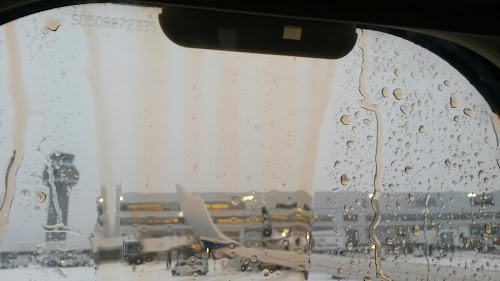 |
| De-icing fluid dripping down the window from the top of the aircraft. |
Wednesday, August 3, 2011
At the Cabin: AK2011 Day 4
 After dinner and beer at Buckets, we made our way back to the cabin, which we hadn't stayed in for three years. The canal looked about the same as it did in 2008, possibly with a few more moose-munched cottonwood trees growing here and there along the bank.
We walked around and looked at the sights:

Boats.

Reflections from boats and cabins.

Float planes and more reflections.

Old, licheny docks and fish-cleaning tables.

More float planes, this one roaring by to land upriver.
 After the seaplane landed, it taxied up the canal to pull in and tie up. While we were there, several float planes came to stay near the canal by the cabin; I counted as many as four at once, maybe five. These are quite popular for hieing down to the river when the reds come running in large numbers, as they had a couple days prior to our arrival on the Kenai. The sockeye surge was just beginning to come into the upper river, and fish-cleaning operations were going on all around us. People typically have tables right along the river or canalside; some fishermen and fisherwomen bring portable cleaning tables over to the river from their off-river cabins.
 We decided to go for a walk, to check out a fishing spot I knew we could use (if we could just figure out how to put wet flies on rods for the reds or could find any non-leaky hip waders).
Sights seen along the way:

Leaves, twigs, and dried spruce needles.

Cotton from cottonwood trees, on what looks like gravel from graywacke.

Miscellaneous cabinish junk and Alaskana, including this scenic (IMO) old pickup.

Fishing related decorations: old floats.

Fishing-related decorations on cabins, garages, and carports.
 We did make it down to the fishing hole, decided to wait for further instructions from the fisher-people arriving the next day, a day that would be dedicated to fishing, getting new hip waders, and eating dinner at the St. Elias Brewery.
Friday, September 5, 2008
Getting There: AK2008 Day 1
 We flew to Anchorage by way of Seattle, flying on one of my favorite airlines, Alaska Airlines, and its smaller cousin, Horizon. Horizon Air is now transitioning to a fleet comprised entirely of Bombardier Q400s, phasing out their Q200s and CRJ-700s for better fuel efficiency. This is the first time I've flown on Horizon rather than Alaska between Reno and Seattle in a very long time - the views aren't quite as good except, perhaps, way in the front or back. (And the plane can be a little louder!) Beer is free on Horizon, though, somewhat making up for the view, and the plane seats two on each side of the aisle, so there isn't that uncomfortable middle seat.
 Upon arriving in Anchorage, MOH and I, along with my parents, immediately proceeded to the famed Moose's Tooth, where some people had beer with lunch, and others had beer for lunch. The beer in question was their Fairweather IPA. There has been some recent interest in beer in the geoblogosphere - Alaska is a great place to check out different kinds of beers for anyone if you get a chance.
Below - a couple photos from inside the Moose's Tooth.

 After reaching satiation at The Tooth, we made the one (and only one this time) obligatory stroll through downtown Anchorage, where we conducted some business and did a bit of window shopping.
 Above, the "yellow mall" with an example of the ever-present Alaskan-summer, hanging baskets of flowers.
 T-shirt shops and cocktail lounges...
 Bookstores, more flowers, and gold nugget shops...
 Street scenes (the yellow mall, again, next to some blue building)...
 Reflections of window shoppers in an artistic, Alaskan window...
 And finally, we make our way eastward, past mid-town to our not-so-final destination, under cloudy skies, with fog or sprinkles hanging over the Chugach Range.
The question is, is it summer or fall? The answer is barely visible in that last picture: some barely blooming fireweed stalks on the side of the road.
Subscribe to:
Posts (Atom)