Showing posts with label 3 Creek Rd. Show all posts

Monday, December 19, 2011

Over the Plateau and Into the Canyon

With this belated post, I'm returning to our last trip north, which was now more than a month ago. At first I thought I'd do this in the spirit of Evelyn Mervine's geology picture a day — but these are not all geology photos, and I'm going to bunch 12 together, hoping that will hold me until I can get around to another continuation, whenever that will be.

Our November trip north began here, with some wintry views and with us leaving the Great Basin for the Snake River drainage, and continued here, as we drove by an intrusive contact and then north into Idaho.

The 3 Creek Road begins in the tiny burb of Rogerson, which sits along Highway 93 between the Nevada-Idaho stateline and Twin Falls, ID. From Rogerson, the road rambles west toward Salmon Falls Dam and points beyond (MSRMaps location). The sign at the beginning of the 3 Creek Road says Salmon Falls Dam 7, Murphy Hot Springs 49, and Jarbidge, Nevada, 64. Possibly you can guess our destination.
Here, not long into our side trip (the side trip being the main point of the entire trip), we are driving over the old, one-lane Salmon Falls Dam.
At this point, the 3 Creek Road still shows signs of the earlier snowstorm: a bit of snow on the sides of the road, and ice in shadowy curves. The Jarbidge Mountains sit in shadow in the not-so-far distance.
The 3 Creek Road crosses miles of plains consisting of fairly flat plateaus and rolling hills, all variably incised by creeks and rivers draining northward to the Snake River.
A snowy but inviting road traversing the hills to the north catches my eye. If driven, would it take us all the way to the Snake River?
This is a typical view of the southern part of the Snake River Plain, looking west from the 3 Creek Road where it is about to descend into one of the intervening valleys.
We finally left the 3 Creek Road, dropped into the gorge of the East Fork of the Jarbidge River, came to The Jarbidge Forks, and drove south into Nevada along the main fork of the Jarbidge River. Hoodoos in the rhyolitic Cougar Point Tuff appear near the Idaho-Nevada state line.
Most of the hoodoos are in Nevada, certainly the best ones are!
A bush or small tree grows atop a double hoodoo.
The snowy road curves ever onward, giving us glimpses of the canyon walls and mountains above Jarbidge.
Sun glows on the hills we hiked in the summer of 2010, on stands of subalpine fir, limber pine, and whitebark pine.
We arrive, get a room in the middle of a locally critical football game, go for a walk through the snow, and end up at the Red Dog Saloon for beers and burgers.

Tuesday, December 21, 2010

2010 Oregon Trip Series

While going through my posts for the last two memes (12MoMeme and travel meme), I noticed a lot of unfinished business. I have a huge number of drafts (87!), many of which will never see the light of day, but which I hesitate to delete for various reasons. And I have a few ongoing or nearly complete series. Some of the series will, with any luck, be picked up next year. The Oregon Trip series is nearly complete, but needs to be posted all in one place, for my sake if for no one else's. So here goes.

In late July, MOH and I took a trip to central Oregon for a family reunion. We took four days in getting there, we spent three days there, and we took two days in coming back. For the first four days, I have four rather long posts with lots of pictures. For the three days in central Oregon, I have four posts, all from a single geological field trip on one day. For the two days coming back, I so far have six posts, and haven't even gotten us back to Winnemucca. When that will happen remains to be seen; the last post was written in October. So, this is it: the 2010 Oregon Series as it stands now, with a good deal of geology, lots of photos, some flora and fauna, and a few scattered beers and brewpubs. The geology seems heavy on the volcanic rocks and volcanoes, perhaps fitting for a central Oregon trip.

Getting There:
Oregon Trip Day 1: A Brewery, Some Geology, Wildlife, and Other Stuff: To Jarbidge, NV, via the Ruby Mountain Brewery. Includes the Great Basin to Snake River Plain transition, mesas capped by ash-flow tuff, an intrusive contact, an old hot spring or two, a basalt dike, wildlife, and more.

Oregon Trip Day 2: A Hike near Jarbidge across Two Rhyolites: Jarbidge, NV. Includes the Jarbidge Rhyolite, Cougar Point Tuff, flow foliation and flow lineation, trees, wildflowers, and the canyon of the Jarbidge River.

Oregon Trip Day 3: Hoodoos, a Snake, more Rhyolite, and Another Brewery: Jarbidge, NV, to Baker City, OR. Includes the Red Dog Saloon, hoodoos in the Cougar Point Tuff, the Jarbidge Forks, jointing in the Dorsey Creek Rhyolite, a snake, a marmot, Salmon Falls Dam, waterfalls into the Snake River at Thousand Springs, and Barley Brown's Brew Pub.

Oregon Trip Day 4: Coffee, Fossils, Formations, Basalt, and Brew: Baker City, OR, to Redmond, OR. Includes a bit of Baker City, part of the Blue Mountains, larch and other trees, John Day Fossil Beds at Sheep Rock, the Columbia River Basalt Group with columnar jointing, the Rattlesnake Tuff and other ignimbrites, and the Red Dog Depot.

Our Field Trip:
Travel Tuesday: Central Oregon: A few pictures from Smith Rock State Park near Terrebonne, OR, and the Terrebonne Depot with Terminal Gravity IPA.

Oregon Trip Day 7: The Tuff of Smith Rock: The tuff of Smith Rock at Smith Rock State Park near Terrebonne, OR, with photos of distant Cascade volcanoes and columnar-jointed basalt.

Oregon Trip Day 7: The Petersen Rock Garden: The Petersen Rock Garden near Redmond, OR, with rocks, lots of rocks, ponds, and peacocks.

Oregon Trip Day 7: A Volcano Observatory: The Dee Wright Observatory on McKenzie Pass, with lots of volcanoes and volcanic rocks, birds, threatening clouds, and a bit of Sisters, Oregon.

The Return Trip:
Travel Tuesday: Cliff near Summer Lake, Oregon: A neat volcanic cliff, with basalt and interlayered volcanic ash or tuff, and a mosquito festival in Paisley.

Ancient Shorelines and a Basalt Dike southeast of Paisley, Oregon: Shorelines of ancient Lake Chewaucan and a basalt dike.

Turning Off onto the Winnemucca-to-the-Sea Highway: North of Lakeview, OR. The turnoff from Highway 95 to Highway 140, with a song that mentions Winnemucca.

Friday Field Photos: Mystery Cracks: West of Adel, OR. Some columnar-jointed basalt with possible spheroidal weathering.

Deep Creek Falls: Continuation of our Oregon Roadtrip: West of Adel, OR. A nice waterfalls over columnar-jointed basalt.

Highway 8A: The Cutoff from Cedarville to the Winnemucca-to-the-Sea Highway: Oregon-Nevada state line on Highway 140 to the junction with Highway 8A. Signs, roads, more signs, and 8A stories.

Onward to Denio Junction!: Highway 140 from its junction with S.R. 8A to Denio Junction. Volcanic flow (rhyolite?) and roadside sediments, signs, and the oasis of Denio Junction.

Onward to Winnemucca!

Friday, August 6, 2010

Oregon Trip Day 3: Hoodoos, a Snake, more Rhyolite, and Another Brewery

Continuing on toward central Oregon [this leg of the journey goes from Jarbidge, Nevada, to Baker City, Oregon, through the Snake River Plain], we awoke early in Jarbidge (NOT!), and took our leave of the town. Before leaving, though, we got a tour of the Red Dog Saloon, which is only open in winter.
Bar and cafe operations in Jarbidge, NV, are divided between the Outdoor Inn in summer and the Red Dog Saloon in winter. The reason for switching from one venue to the other is that the Red Dog is smaller and is therefore easier to heat during the cold, snowy winter months.

Here are a few other Red Dogs I've been to: Red Dog Saloon, Juneau, AK; Red Dog Saloon, Virginia City, NV; Red Dog Depot, Redmond, OR; and it seems like I'm missing one somewhere.

UPDATE 8Dec2013: Finally found the other Red Dog Saloon I've been to, located as always in Needles, CA. And here's one I've not visited.
Besides a few scattered Mormon crickets — which for some unknown reason were located mostly on the Idaho side of the road from Jarbidge to the Jarbidge Forks — we came across this rattlesnake hiding in the shade, looking to get run over. We promptly swerved while skidding to a halt.
I shot a few pictures of the snake coiling and poised to strike, but most of them came out blurry. The reason it was taking such a striking attitude? MOH was pushing it off the road with a stick, so it might not get run over or shot by anyone.
It finally did make it into the rocks by the roadside; we figured it might just come back out onto the nice, flat road where it would be in danger again, but don't know what went down after we left.
These are steep, roadside cliffs in the Cougar Point Tuff about half way between Jarbidge and the Jarbidge Forks (cliff location Google Maps), still south of the Idaho border in Nevada.

Photo: Cliff in the rhyolitic Cougar Point Tuff.

You can read a little about the Cougar Point Tuff here (Bonnichsen, 1991), and also in the my Day 2 trip report, where I show a couple close-up photos.
We had a hard time getting through this part of the canyon. Hoodoos kept popping up, especially above (and also below) a relatively thin and crudely columnar-jointed unit in the Cougar Point Tuff. We pulled into this pullout and to take pictures of these hoodoos...
...hoodoos that include this natural arch.

Photo: The Jarbidge Forks.

We finally made it, slowly but surely, to the Jarbidge Forks, which is in Idaho. The East Fork of the Jarbidge River, center and foreground of the photo, comes into the Jarbidge River, left part of the photo, and they both continue downstream to the right (north) as the Jarbidge River. We had been driving downstream along the Jarbidge River; now, for a relatively short distance, we would follow the East Fork upstream to Murphy's Hot Springs.

Photo: Some wild jointing and fracturing in the Dorsey Creek Rhyolite.

This is the Dorsey Creek Rhyolite at the Jarbidge Forks. It falls into the voluminous silicic lava flow category and erupted about 8 million years ago from sources within the Bruneau-Jarbidge eruptive center, which was centered downstream (north) of this Jarbidge Forks location. According to Bonnichsen, 1991, the Dorsey Creek Rhyolite is more than 650 feet thick in Jarbidge Canyon.
In this photo, also taken from the Jarbidge Forks, you can see some nice flow folding in the Dorsey Creek Rhyolite. Some of the flow foliation or folding in this large-volume rhyolite flow is similar to compaction or flow foliation present in densely welded to rheomorphic parts of the Cougar Point Tuff (photos in the Day 2 trip report). Distinguishing large-volume rhyolite flows from rheomorphic tuffs can be difficult.
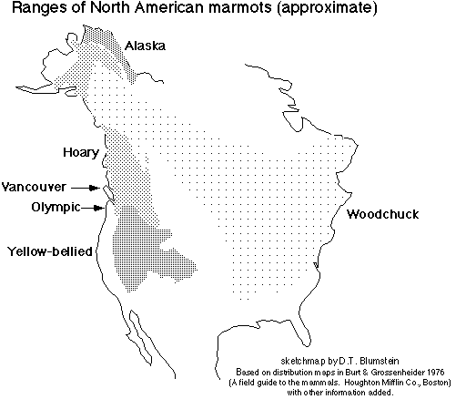
While driving through Murphy's Hot Springs, ID, we spotted this marmot, likely to be a yellow-bellied marmot, Marmota flaviventris, according to this distribution map.
And then we took the grade out of the canyon of the East Fork of the Jarbidge River, getting a nice view of the canyon with the Jarbidge Mountains in the background. That's all Cougar Point Tuff in the canyon walls (Bonnichsen, 1991).
The rest of our trip on the third day was fairly uneventful saving one more crossing of Salmon Falls Creek at across the one-lane Salmon Falls Dam...
...and a nice view of the Thousand Springs area near Wendell, Idaho, just before we crossed the Snake River on old Highway 30 (MSRMaps).

According to this sign, a lava flow — or more than one? — changed the "geologic structure" of the area, resulting in formation of the many springs.

"Over thousands of years, volcanic activity repeatedly spread lava over the Snake River Plain, slowly forcing the river southward in a great curve. Successive channels of the river and its tributaries were filled with spongy lava, and became both reservoirs and underground conduits, gathering water from far to the northeast. Torrents from one or more of these buried channels burst forth on the opposite canyon wall."
I can't vouch for this description, but it sounds plausible, if somewhat general.
Many hours passed as we drove west to northwest on I-84; we finally came to Baker City, Oregon, and settled into a motel. We then immediately walked over to Barley Brown's Brew Pub. We both had the WFO IPA (Wide *Freaking* Open) and had a taste of the Hot Blonde, which is brewed with jalapeño peppers and went well with the south-of-the-border–style Ceasar salad I had. Highly recommened! Their beers as of more than a year ago.

Trip report to be continued...

Some References:
Bonnichsen, Bill, 1982, The Bruneau-Jarbidge Eruptive Center, Southwestern Idaho, in Bill Bonnichsen, and Roy M. Breckenridge, eds, Cenozoic Geology of Idaho: Idaho Geological Survey Bulletin B-26. p. 237-254.

Bonnichsen, Bill, 1991, Geology of Scenic Jarbidge Canyon Near Murphy Hot Springs, Idaho: Idaho Geological Survey, GeoNote 16, 2 pp.

Bonnichsen, Bill and Jenks, M.D., 1990, Geologic map of the Jarbidge River Wilderness Study Area, Owyhee County, Idaho: U.S. Geological Survey, Map MF-2127, scale 1:50000.

Cathey, Henrietta E, and Nash, Barbara P., 2004, The Cougar Point Tuff: Implications for Thermochemical Zonation and Longevity of High-Temperature, Large-Volume Silicic Magmas of the Miocene Yellowstone Hotspot: Journal of Petrology, v. 45, no. 1, p. 27-58.

Henry, C. D., and Wolff, J. A., 1992, Distinguishing strongly rheomorphic tuffs from extensive silicic lavas: Bulletin of Volcanology, v. 54, no. 3, p. 171-186 (links to abstract).

Starkel, W. A., Bonnichsen, B., Godchaux, M., Boroughs, S., and Wolff, J., 2006,
Far-Travelled High-Grade Ignimbrites or Widespread Generation of Low-d18O Magma? The Problem of the West Bennett Hills, Snake River Plain, ID: American Geophysical Union, Fall Meeting 2006, abstract #V51D-1704.

Monday, August 2, 2010

Oregon Trip Day 1: A Brewery, Some Geology, Wildlife, and Other Stuff

I just returned from a mega-trip with MOH into central Oregon, where I met with family at an annual reunion-type affair on a basalt-capped bluff overlooking a small Oregon town. We spent four days getting there, spent three days there, and rushed back in two days.

Our first stop was the Ruby Mountain Brewing Company at Angel Creek Ranch, which is a little south of Wells, Nevada.
The brewery is a small affair on an operating ranch along the eastern range front of the East Humboldt Range. We had a taste of two brews, then purchased a couple cases, which we took with us for delivery to the reunion, keeping it cold in a large ice chest in the back of the Prius.

We like the Angel Creek Amber Ale and the Buckaroo Brew Pale Ale. The pale ale, which isn't listed on their website, was originally made for the Western Folklife Center and the National Cowboy Poetry Gathering in Elko.

Be sure to call ahead if you plan to visit this brewery, otherwise they might be out dealing with cows, horses, hay and the like.
Photo: Leaving the Great Basin; Mesas are capped by welded tuff.

After driving north on Highway 93, we crossed the California Trail and then left the Great Basin by dropping into the Snake River drainage region. The photo looks a little north of northwest from Highway 93 near Henry (Google Maps Street View). The mesa on the very left is Big Devils Table, the mountain on the right is Ellen D Mountain, and the main drainage cutting the mesas a little right of center is Salmon Falls Creek (MSRMaps). According to this map, the dark brown mesas are capped by Tts, which includes ignimbrites and tuffs of the Idavada Formation and may include the rhyolitic Cougar Point Tuff (Tcp). Sediments mapped as Ts3 underlie the capping rhyolitic tuffs. The dark-brown mesas look like basalts from a distance but aren't.
Photo: Dipping beds and granodiorite.

After making a turn to the northeast, the road goes toward the siding of Contact and passes by China Mountain, where you can see some sedimentary layers (center and right) dipping moderately to steeply to the south, away from a granitic pluton (left). The plutonic rocks are mapped as Jgd (Jurassic granodiorite) on the same geologic map; the seds are mapped as PMl (Upper Mississippian to Lower Permian limestone, along with shale, chert, orthoquartzite, and siltite). The intrusive contact between the sedimentary and plutonic rocks might be what the siding of Contact is named for; it also might be named for the contact-metamorphic mineral deposits and prospects of the Contact mining district. This aerial photo shows the beds and contact fairly well.
Photo: A closer view of the intrusive contact.

Highway 93 then cuts through the Jurassic granodiorite for at least a few miles, providing ample opportunity for closer viewing at roadcuts.
We drove by an old hot springs south of the NV-ID border and wondered about its status, but didn't check it out. It's not listed in my hot springs books, and not shown on the topo maps (building is in the upper center of this air photo).
We crossed Salmon Falls Creek not once or twice (above), but three times, the third being a crossing at Salmon Falls Dam.
After what seemed like a long trek on the Jarbidge Road across variably flat to hilly country with the occasional canyon, we dropped into the canyon of the East Fork of the Jarbidge River heading for the Jarbidge Forks. In my two drives down and one drive up this part of the road, I was too busy looking at the canyon to notice this man-made rock wall.
A view of the rock wall looking straight up: the wall is on the left, it then meanders over to the center where it joins a horizontal flow basalt capping the ridge.
We took a quick drive through Murphy's Hot Springs, which doesn't have an active commercial operation at the moment — but maybe it's for sale! Murphy's Hot Springs is mostly a small, private settlement, with at least one road crossing the East Fork of the Jarbidge River.
We arrived in Jarbidge after very slow driving on the narrow, one-laned road (read more about the road in here). We checked in, checked the place out, and went for a walk around town, where we flushed out a deer or two.
We didn't see any dingoes.
There are a lot of old pieces of this and that kind of equipment and relics around town, including a photogenic old CAT from an unknown era.
Finally, we stopped in at the Outdoor Inn, whose sign boasts "Booze, Grub, Rooms."
This is the current beer selection. MGD? Or a Ruby Mountain ale?

Trip report to be continued...

Some References:
Bonnichsen, Bill, 1991, Geology of Scenic Jarbidge Canyon Near Murphy Hot Springs, Idaho: Idaho Geological Survey, GeoNote 16, 2 p.

Hope, R.A. and Coats, R.R., 1976, Preliminary geologic map of Elko County, Nevada: U.S. Geological Survey, Open-File Report OF-76-779, 1:100,000.

Thursday, February 4, 2010

Road to Jarbidge: To the Jarbidge Forks

The Jarbidge Mountains—visible in the distance to the south and southwest (left)—are in Nevada; we are still in Idaho, trying to make it to Nevada. Here, we haven't really come to the end of the 3 Creek–Jarbidge Road, we've merely come to the end of the pavement: Pavement Ends.
The sign says: Hill [squiggly] Slow - Next 2 Miles.
And with the north end of the Jarbidge Mountains in the background, the dirt road curves and descends into the canyon of the East Fork of the Jarbidge River. The sign says: Watch For Ice. I didn't see any ice, but it was fall—maybe not the right time of year.
The road down into the canyon is fairly narrow, with a cliff on the right and air on the left. I didn't notice any pullouts, so taking photos of the scenic canyon was tricky.
I stopped briefly in the middle of the road at one point and looked south up the East Fork toward the Jarbidge Mountains.
I then completed the descent, arriving at the bottom of the canyon at the same time I arrived in Murphy's Hot Springs. The place appeared to be inhabited, but I didn't drive in to see if a commercial hot springs is currently in operation. The Idaho Office of Energy Resources lists Desert Hot Springs Resort (aka Murphy's Hot Springs) on their Geothermal Springs of Idaho page; they then link to Hot Spring Heaven (dated April/May 2000), which tells the history of Murphy's Hot Springs and gives an out-of-service number to call for information or reservations. So, another trip will be required determine the status of the springs and small settlement.
Driving northwest along the East Fork of the Jarbidge River, I spotted a couple pullouts occupied by hunters and other campers. The road is narrow enough in places to prevent the passage of two side-by-side vehicles, so I had to watch constantly for traffic coming around corners, traffic that included people on 4-wheeler ATV's. The sign says: Watch For Falling Rock.
These are some of the rocks that warrant watching, in case they start falling. The exposure is most likely part of a formation commonly or at least locally known as the Dorsey Creek Rhyolite or rhyolite of Dorsey Creek. I didn't stop to examine these rocks: I didn't see pullouts in appropriate places. Maybe some other time.
I finally arrived at The Jarbidge Forks, Idaho—at 3:10 in the afternoon on the first day, and 12:15 pm on the second day. This is where I decided to turn around on the first day, not knowing that I could have gotten gas, food, and lodging 23 miles down the road in Jarbidge, Nevada.
The Jarbidge Forks consists of the intersection of the East Fork of the Jarbidge River coming in from the southeast, with the main Jarbidge River coming in from the southwest. Farther downstream to the north, the Jarbidge River joins the Bruneau River before the Bruneau flows into the Snake River near Bruneau and Grand View, Idaho. You Are a Long Way From Anywhere, warns this informative sign.
I stopped here both days, to take in the river and canyon views. This shot of the Jarbidge River is looking downstream to the north.
And this photo of the Jarbidge River looks upstream to the south. There's a boat ramp just out of view for river runners, usually expert kayakers.
This is some of the most isolated country anywhere. If you get into trouble on the river, you're probably the one who will have to get yourself out of it.
Info and nice canyon pictures.

A few Dorsey Creek Rhyolite References:
Bonnichsen, Bill, 1982, The Bruneau-Jarbidge Eruptive Center, Southwestern Idaho, in Bill Bonnichsen, and Roy M. Breckenridge, eds, Cenozoic Geology of Idaho: Idaho Geological Survey Bulletin B-26. p. 237-254.

Bonnichsen, Bill, and Breckenridge, R. M., eds., 1982, Cenozoic Geology of Idaho 1982: Idaho Geological Survey Bulletin B-26, 725 pp.

Bonnichsen, Bill and Jenks, M.D., 1990, Geologic map of the Jarbidge River Wilderness Study Area, Owyhee County, Idaho: U.S. Geological Survey, Map MF-2127, scale 1:50000.