Friday, December 26, 2014

Cliffs of the Ruby Mountains: More Views from the Hanging Valley Pullout

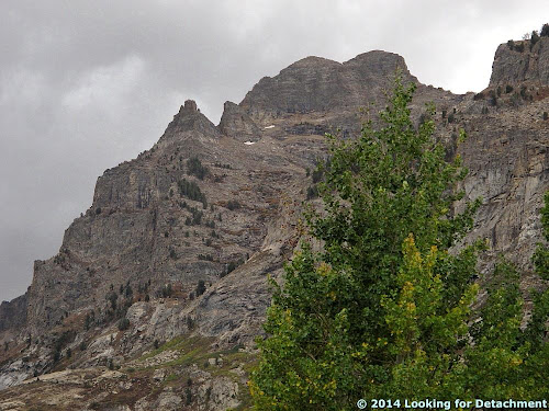
While I'm gradually working my way toward posting a bit about the nappe in Lamoille Canyon, let's take a quick look at more views of the cliffs from the hanging valley pullout.
A shadowed view of the cliffs to the northwest.
Stunning!
A view of the cliffs to the southeast.
When I took this photo, it looked like I could see a recumbent fold in the upper cliffs. I'm not sure that there is really a fold present, and in fact, I missed getting a shot of the nappe in Lamoille Canyon by just a little bit!
Small dikes or sills cutting the cliff walls.

Friday, December 19, 2014

Big Slushy Wet Snow Hits Northern Sierra; Some Folks Lose Internet

It's slushy at 4600 feet, anyway.

Our phone service--hence internet--is down, so I'm using a 1X Verizon connection. It's just a little slow!

I imagine there's a lot of snow at higher elevations, but the details of this storm are difficult to check out at 1X.

Thursday, December 11, 2014

Twelve Months of LFD 2014

I missed this retrospective meme last year (as I also did in 2011), but here it is, back again, per DrugMonkey:
The rules for this blog meme are quite simple.
-Post the link and first sentence from the first blog entry for each month of the past year. I originally did this meme, after seeing similar posted by Janet Stemwedel and John Lynch. Prior editions include 2012201120102009 and 2008.
Previous takes on this Twelve Month meme at LFD were posted for 2008, 2009, 2010, and 2012. As usual for LFD, I've also added the accompanying first photo of the month, where there was one with the first post of the month, and a gratuitous sign photo for October.

So, here's the year 2014 for LFD:
January:
I'm sitting here inside flight 112--I think--with my phone in airplane mode, wondering if I can create a blog draft that I can save and post later.

February:
We've been having unsettled to stormy weather here in western Nevada for about the last week, with at least light snow accumulating in the mountains, though the south facing slopes have gone back to being mostly bare, even under today's cloudy skies.

March:
Flying back from Alaska on yet another recent trip, I was able to spot Rose Spit, which featured as Where in the West challenge back in October of 2010.

April:
A while back, I started collecting photos of Majuba Hill (AKA Majuba Mountain), partly because I pass by daily on the way to and from work, and also because of it's interesting shape and fascinating geology (which I hope to learn more about on this spring's GSN field trip).

May:
MOH and I will shortly be off on a field trip to a few nearby localities, including Majuba Hill, reportedly a great mineral and rock collecting site, seen here from I-80 looking northwest across Rye Patch Reservoir.

June:
Here are a few photoviews from Majuba Hill, while I get it together to take some rock photos:

July:
A quick report on a canoe trip we took recently:

August:
So, while I wasn't thinking about it, my 1000th post posted, and this is my 1005th! I'm not sure, really, what to say about this — although I'm also sure I'll think of something — other than Yay!!

September:
The sun is about to rise through thick smoke blanketing the
southern Humboldt Range.

October: A colleague of my former (deceased) husband once said, "Archaeologists are the Cowboys of Science."
[He was wrong, btw. Read the post to find out why.]

November:
So there I was, traveling west on I-80 late last week — just after our first rain sans snow (except for at the high elevations of a few mountains east of the Sierra, like the Humboldt and Sonoma Ranges, which top out at 9836 and 9396 feet respectively), and before our most recent larger rain and snowstorm of this past weekend — when I came to the marshes that border the west end of the Fortymile Desert.

December: MOH turned me on to this song just yesterday (I didn't listen to much besides classic rock and country in the 80s).


Sammy Hagar: I Can't Drive 55 (lyrics)
Album: VOA, 1984

Thursday, December 4, 2014

Monday, December 1, 2014

Road Song: I Can't Drive 55

Sammy Hagar: I Can't Drive 55 (lyrics)
Album: VOA, 1984

MOH turned me on to this song just yesterday (I didn't listen to much besides classic rock and country in the 80s). The song refers to the National Maximum Speed Law (part of the Emergency Highway Energy Conservation Act) enacted in 1974 in the wake of the 1973 oil crisis. Nevada got around this law by issuing "wasting energy" tickets of $5 beginning in 1981, and although Wikipedia — and its cited source — states that "troopers were directed not to take the new law as a signal to stop writing tickets," as far as I noticed, speeding tickets were no longer issued for speeds under 70 mph (except perhaps on rare occasions). At 70 mph, you were going 15 miles over the actual speed limit, so you could be given a speeding ticket along with a reckless driving ticket, and on some roads (like the Mount Rose Highway and the Geiger Grade), you could be issued a reckles mountain driving ticket as well (higher fines).

Monday, November 24, 2014

More Dust Devils

I often have occasion to see dust devils while traveling through Nevada, especially in the dryer months, but any time of year can afford the right conditions: a dry playa or dirt road (and other surfaces, read more here) and thermally unstable air. And so, while driving through the Fortymile Desert and about to pass by the Nightingale Hot Springs exit on I-80 back in early October —  the exit name combines two locations into one: Nightingale is from an old mining district and ghost town  in the Nightingale Mountains north of the freeway; Hot Springs is from the geothermal area at Brady's Hot Springs just south of the freeway — I noticed a large plume of dust rising from the desert just north of the highway. I pulled off, securing a viewing point near a powerline road crossing the main road going north to Nightingale.
Several dust devils, including the large, obviously whirling one, and a few tiny ones. Photo looks southwest toward basalt covered hills on the east side of the Truckee Range.
The large devil and three small ones apparently trailing it.
The same large dust devil, this time with two tiny ones seemingly leading.
Here, the same large dust devil appears to get all torqued out of shape!
Later, just for good measure, I took a photo of this devil, also in the Fortymile Desert; our view is southward toward the West Humboldt Range.
This last devil was located about 14 or 15 miles east of the group near the Nightingale Hot Springs exit. The white, rectangular thing on the horizon in the left part of the photo is a semi heading north on U.S. 95, about to reach I-80 near the old site of Trinity (MSRMaps location; Google Maps location).

Thursday, November 13, 2014

A Hanging Valley in Lamoille Canyon

Getting back to Lamoille Canyon, a place of stunning cliffs and glacier carved valleys, I'm going to take us to an up-canyon viewpoint where we can see one of many hanging valleys. MOH and I initially came to this valley by way of the last stop on our second-day, GBR field trip. The roadside pullout, compleat with descriptive sign, can be reached easily by paved road by driving about 1.5 miles past Thomas Canyon campground.
The hanging valley, as seen from a pullout along NF-650,
looking up (way up) and to the southwest.
From the vantage point of the pullout, you can look straight up and see the hanging valley above a rocky, vegetated cliff. A narrow, V-shaped rill is curving it's way down the 450 feet of cliff below the U-shaped, glacially carved bowl above, which we can barely see from this vantage point. The triangular peak behind the dark green cleft in the cliff towers over us at just over 11,000 feet.

By Yosemite standards, this cliff is really not that high above the valley floor, and there isn't a waterfall pouring out of our hanging valley, the way Bridalveil Fall rushes over the cliffs near Cathedral Rocks, but our little cleft is green with dense vegetation, indicating that the creek flows at least part-year (a feat in and of itself in Nevada) — and you can drive right to it. On pavement! (Pavement in Nevada is a real bonus.)

Before leaving the pullout, you can read a sign about the hanging valley and the tributary glacier that created it, and if you have the time, you can take the Hanging Valley nature trail through the aspens to Lamoille Creek and a beaver pond or two. Not sure if the trail continues uphill into the hanging valley — the cliff looks quite steep and brushy — but I suspect you can get to the valley via some other route.
Turning to look at the opposite canyon wall, you'll see a sheer cliff with a narrow chute carved into it. The slicked canyon rocks show where water has flowed persistently, probably with small casdcading waterfalls at some times of most years; those areas are now marked by black vertical lines where water has deposited dark minerals, often manganese oxides of some type, and where algae or lichen might get a toe hold.
Topo map of the area (USGS TNM 2.0 Viewer link), centered about on Thomas Creek, showing several hanging valleys around the area.
"Our" hanging valley marked by a star.
Topo map (TNM 2.0 Viewer link) centered on our valley, also showing most of two other hanging valleys to the northwest and southeast of it.
Google Earth view approximating the view shown in the last topo map.
The views all around from the hanging valley pullout are stunning, and a drive up Lamoille Canyon in the Ruby Mountains is always well worth the time.

Thursday, November 6, 2014

Sluggish Fly on A Pyritic Boulder

It's not like it's a meme or anything, but I saw a sluggish fly on limestone at Really Going Places — after taking these photos on the first day of November — and thought, what an opportune time to post photos of this fly, also sluggish, on a pyritic parking lot erratic (glacial erratic? not sure).
Iron-stained rock with a large mass of pyrite in the upper right, with fly for scale
(a bit left of the large pyritic mass)..
The same mass with the fly close to a large pyrite cube.
Now the fly has wandered over a bit to the left (out of the first photo's range), and is standing at a small precipice, appearing to check out the tiny pyrite cubes below.
Here, I've had to give the fly a gentle nudge, because I wanted it to move closer to the tiny pyrite crystals (that's how sluggish it was!).
The fly now looks like it's interested in mining the tiny cubes!
And now the fly has moved over a bit back to the right (barely into the first photo), and is checking out a couple veinlets.
And here's one last photo, for those of you who prefer not to see a fly for scale.
The funny, almost sickly yellowish green color on the outside of this rock indicates that you should be able to find some kind of sulfide mineral inside — in this case, a heckuva lot of pyrite. This color can be used as an exploration guide, provided that one wants to find an ore deposit rich in sulfides.

Tuesday, November 4, 2014

Update from the Road: It's Finally Fall

So there I was, traveling west on I-80 late last week — just after our first rain sans snow (except for at the high elevations of a few mountains east of the Sierra, like the Humboldt and Sonoma Ranges, which top out at 9836 and 9396 feet respectively), and before our most recent larger rain and snowstorm of this past weekend — when I came to the marshes that border the west end of the Fortymile Desert.
One of the marshes bordering the west end of the Fortymile Desert,
just northeast of Fernley (location).
I was pleased to see that the marshes were fairly rich in water, and that even the median between the eastbound and westbound sections of freeway had patches of water. The volume of water in the marshes, in the median, and in the adjoining playa and Fernley Wildlife Management Area varies considerably, and though the area has been somewhat drier than usual this last year, I've never seen the marshes completely dry. I enjoy driving this section of I-80: I often see birds in the marshes, including American avocet and black-necked stilt.

I passed through Fernley, stopping briefly at the Gilpin rest stop (AKA Wasdworth rest area), always a good place to find excellent fall colors.
Trees at Gilpin.
And a closer, brighter view.
I had already crossed the main bridge over the Truckee River, between the west Fernley and west Wadsworth exits, and I had been surprised to see that the trees along the river were still yellow. They had been, I thought, nearly at peak about two weeks prior, so I really didn't expect to be seeing much besides some faded golden brown leaves or maybe even mostly barren trees.

Instead, fall was in full swing, and I was reminded that the same was true just almost exactly a year ago when I passed through and decided to exit at Painted Rock to get a closer view of the leaves.
Cottonwood trees along the Truckee River, October 24, 2013.
The river and colorful trees, from the one lane Painted Rock bridge (location).
This year, I didn't exit anywhere along the river (besides Gilpin/Wadsworth), opting instead to move through the canyon as quickly as possible (such are the vagaries of a traveling life).

After driving into Reno, I navigated the notorious Spaghetti Bowl, turning north onto 395. Eventually I stopped at the Honey Lake rest area.
Maple tree at Honey Lake rest area, October 30, 2014.
Same maple tree on October 24, 2013.
The changing leaves and general fallishness of the marshes reminded me of a detailed sequence of events from last year — of the bright golden leaves turning and falling in the canyon of the lower Truckee River, of other leaves turning and falling elsewhere along the road, and of the bright yellow aspen leaves in our yard, also turning and falling. We don't have aspen trees in our yard anymore (we had to make space for gardens and trees that don't perpetuate themselves through annoying, ever-present and ever-growing roots and sprouts), so we don't have our own bright colors and fallen leaves (except for on a few small plants in the midst of growing), but I know that fall will always come about this same time every year — often with bright colors — and possibly I will always feel nostalgic for the days gone by.

Wednesday, October 22, 2014

Cliffs of the Ruby Mountains: Mt. Gilbert

The glacially carved cliffs around Camp Lamoille are truly spectacular — and while we were, now nearly a month ago — they provided us with constant fascination and wonderment amid the ever-changing light and cloud effects. To the south of us, besides Ruby Spire and the Wolf's Ear (seen in this earlier post), Mt. Gilbert towered over us at 11,120 feet.
A view of Mt. Gilbert, the highest point near an unnamed spire, as seen on the second day from the trail near the South Fork beaver ponds.
A closer view of Mt. Gilbert and the same spire;
photo taken on the second day from the main part of camp.
In the view above, you can see a couple spots of snow high on the cliffy slopes, probably left over from the previous winter (2013-2014).

Mt. Gilbert is a pyramid-shaped peak, possibly qualifying as a glacial horn, AKA pyramidal peak (British usage?). As you can see below, it's bounded on the west by the large bowl-shaped head of the glacially carved, U-shaped Seitz Canyon; it's bounded on the northeast by a high, well-defined cirque; and it's bounded on the southeast by an irregularly bowl-shaped area, also a cirque.
Topo map from USGS TNM 2.0 Viewer (link), with Mt. Gilbert right of center.
Same map, with the outlines of three circular depressions or bowls formed by glaciers. As you can see, the west side of Mt. Gilbert is essentially one arête. Other horns and arêtes are present in the topo image.
It just occurred to me that the unnamed spire might also be a small horn, but only if the indentation into the cliff below it to the east consists of a small cirque formed from a small hanging glacier (I wish the USGS would provide individual links in their Glossary of Glacial Terminology, but they don't).
What do you think? Is it a horn?
Rain and hail from an intense, long-lasting embedded thunderstorm (or set of storms), pounded the Lamoille Canyon area late on the second afternoon and long into the second night. When we awoke the morning of the third day, the tops of the cliffs and peaks around us were well dusted with snow:
Mt. Gilbert with snow, as seen from camp on the morning of the third day.
A closer view from the same time, same location. The snow highlights the foliation of the metamorphic rocks — gneiss and marble,
possibly with sill-like intrusions of granite.
USGS Glossary of Glacier Terminology

Thursday, October 9, 2014

First Trip into the Ruby Mountains of Nevada

Would you believe...a geologist living mostly in Nevada since 1975, who had never been into the Ruby Mountains until two weeks ago? One who had been over Secret Pass several times and down Ruby Valley once, but never into the mountains?

One reason to go to Lamoille Canyon, if you've never been there, is the excellent scenery. Another reason would be the excellent geology...including geology related to the metamorphic core complex that makes up the Ruby Mountains — along with several, and more than one type, of low-angle faults — and also geology related to the Pleistocene glaciation of the mountains.
Terminal moraine of Lamoille Canyon,
beyond the field that happens to be part of an outwash plain.
The photo above wasn't our first view of Lamoille Canyon, when MOH and I visited about two weeks ago on our way to the NMEC 2nd Annual GBR. That photo is from the second day's morning field trip to see some of the glacial geology of the Rubys (or would that be Rubies?), led by Dr. Mike McFarlane. Instead, our first view of the canyon was as pictured below:
Looking into Lamoille Canyon from just before the entrance to the Ruby Dome Ranch (Google Maps location).
Unnamed hill 9942 forms the flattish-looking knob just right of center, and although it's hard to tell for sure, even from repeated viewings in Google Earth, the jagged knobs in the distance on the left appear to be Ruby Spire at 10,835 ft on the far left, the Wolf's Ear at 10,788 in the center, and an unnamed peak at 10,835 ft on the right (seemingly lower because it's behind the other two jagged knobs). I've gleaned the names Ruby Spire and Wolf's Ear from Panoramio and Google Earth photos rather than from USGS topo maps of the area, suggesting to me that at least some of the supposedly unnamed peaks and knobs of the Rubys may have names known by the locals and other frequenters of the area.
Another view looking into the first part of Lamoille Canyon,
this time from the 2nd day.
With these first views of the canyon, the valley appears to be dominantly V-shaped: the overall U-shape of the valley has been modified by the post-glacial down-cutting of Lamoille Creek.
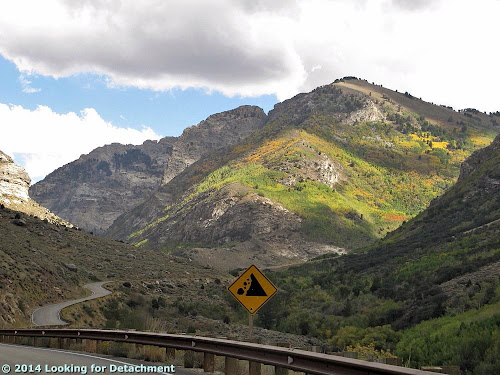
At this point, where a falling rock sign appears on the side of the road, the overall U-shaped nature of the glacially carved canyon can be seen.
The main part of Lamoille Canyon forms the foreground right of the road and highway sign, and it continues to the far left where cliffs of brownish gneiss, marble, and granite abound. The Right Fork of Lamoille Creek shoots off to the right, into the U-shaped canyon where its eastern, sunlit slopes are covered by green, yellow, and orange aspen trees.

The GBR was located at Camp Lamoille (AKA Lion's Camp Lamoille or the Boy Scout Camp), nestled in a flat area along Right Fork Lamoille Creek (or South Fork Lamoille Canyon). Photos of the area shown below are from Days 1 and 2 of the three-day outing.
Looking south up the South Fork of Lamoille Canyon. Back in the rocky section of the canyon, Ruby Spire and the Wolf's Ear are on the left;
Mt. Gilbert is on the right.
This photo is centered on a lateral moraine of South Fork Lamoille Canyon, which blocked the main canyon (to the left) and has been breached by Lamoille Creek.
In the photo above, besides the breached lateral moraine, the upper portion of a couloir called "Terminal Cancer" can be seen on the far left. Ruby Spire (Google Maps location) is in the center distance (highest spire of the jagged ridge on the east side of the Right Fork of Lamoille Creek. The Wolf's Ear (Google Maps location) forms the center of that jagged ridge.
We've arrived in camp. The Wolf's Ear is still visible as the highest jagged knob near the center of the photo.
Rapidly changing lighting at Camp Lamoille.
Wolf's Ear is on the left (east side of the South Fork canyon). Mt. Gilbert is the tallest peak on the right.
Our campsite below the cliffs. You can see in this photo the very minimal spots of snow below Mt. Gilbert, fairly unusual in the Rubys for late September.
A closer view of the Wolf's Ear.
Looking up the same canyon from one of the trails near the beaver ponds.
An even closer view of the Wolf's Ear (dark knob on the left), taken on the stormy second day.
Another view of the South Fork of Lamoille Canyon, taken during a downpour featuring multiple hail events and (later) lightning directly overhead.
Camping in the stormy weather of two weeks ago was fascinating. The overall camping experience, which could have been a disaster, was mitigated by the presence of a wood-heated lodge or dining area, and abundant free food and drinks.