Showing posts with label structure. Show all posts

Tuesday, February 7, 2017

From the Road: Talus Stripes and Shorelines along the Truckee River

Talus, shorelines, and fall colors.
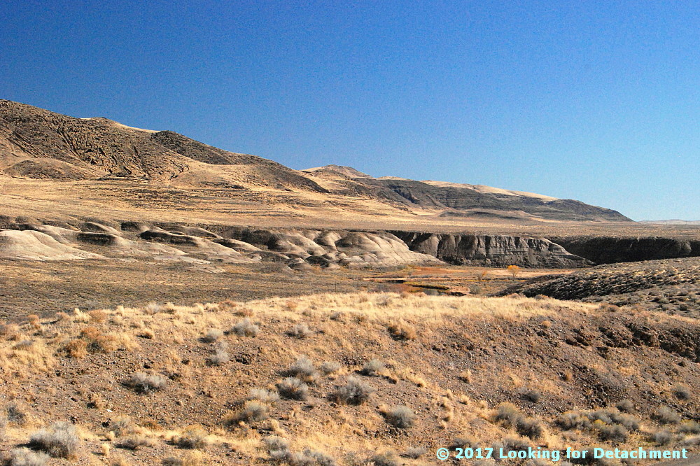
It was a late fall day, and I stopped along Route 447 to see if I could get close to some of the brilliantly colored trees along the Truckee River a few miles north of Wadsworth. I didn't end up finding a good spot for pics of fall colors—other than maybe this one taken down near the Numana Hatchery—but I did find lots of wonderful talus stripes and some Lake Lahontan shorelines.

At two stops a little farther to the north, at and near the junction of 447 with Chicken Road and at the Historic Marker 448 pullout, I grabbed a hodgepodge of photos.
Looking SSE from the historic marker pullout.
These two photos look south-southeastward along the Truckee River toward distant Fernley. A good portion of the river in this area runs parallel or sub-parallel to Walker Lane strike-slip faults. Wadsworth Amphitheater, which shows up in the Google Earth images we'll see in a minute, is not visible from any of our photo sites; it's an amphitheater-shaped topographic feature cut into Lake Lahontan sediments right along the east bank of the Truckee, beyond the dark basaltic hills on the right side of these two photos (east side of the Truckee).
I love the lone Cottonwood in this photo.
I went ahead and drew a few lines on Google Earth, then I rotated the resulting images to two different orientations so we could see a little more of the terrain. Be sure to check the north arrow in the upper right! The linears I drew are parallel or sub-parallel to the trend of the Walker Lane. You might be able to pick out a few more in the images (or go to Google Earth and looking around a bit).

The Walker Lane—on Google Earth (G.E.)and on other aerial representations such as air photos—shows up best at very small scales; that is, if we zoom way out and observe the area from way above, we can see the trend of the Walker Lane better than if we zoom way in, like we've done here. Nevertheless, individual strike-slip faults have been identified throughout the Walker Lane, and a few of these occur right in this area.
The A is centered on Wadsworth Amphitheater. The purple camera icon shows the location of the first photo.
The next G.E. image zooms in to the area we can see in the photos. I've got all three photo locations turned on, the A for Wadsworth Amphitheater, and my drawn-in linears. These linears aren't necessarily faults, although I'm pretty sure the one on the far left is. Unfortunately, because I currently have a very lousy internet setup (thanks Frontier!), I can't load very many research web pages. Google works well—and Blogger is a Google product—so I can blog even with 25 to 100% packet loss (it's 50% this very moment). And because Google Earth is a Google product, it's working for me also! (But I can't routinely access my non-Google email.)

Back to the faults and linears. I do know from personal experience that Walker Lane structures pass through the Lake Lahontan sediments in the area where the Truckee is running in a particularly linear fashion. I know this from some work I did a long time ago with J.O. Davis, who was studying Lake Lahontan and using tephra beds to date various aspects of the stratigraphy. The two linears or faults in the lower right of the image cross through the area where I've seen older Lake Lahontan sediments faulted and highly contorted by the major structures that pass through the area. I can't say that my particular linears are right on the major structures, and I can see other possible lineaments.

UPDATE 3Feb2017: I now have good internet back, and I've been able to compare my "map" to a geologic map of the area (Bell, Garside, and House, 2005). My linear passing through the hatchery location (below) is spot on for their most prominent fault, which was mapped as a dominantly extensional fault.
A zoomed in G.E. view of the area.
Not sure why, but I prefer to spell amphitheater with an "re" at the end: amphitheatre. I also have a hard time sticking the first "h" into the word!

I sure wish Frontier was a better internet service provider! (I never had this kind of semi-routine trouble with AT&T in eastern and northern Nevada; their every-day speeds were faster, and service was (generally) provided more quickly.

Back to the photos! 😊
Horizontal Lahontan shorelines and vertical basaltic talus stripes.
Some of the same talus stripes in Google Earth.
This photo shows a juxtaposition of talus stripes, faint shorelines, and layered Lahontan sediments.
On this trip, I focused mostly on trying to get good photos of the talus, because that's really what caught my eye. I later noticed that a few shots showed the Lake Lahontan sediments fairly well.
White, gray, greenish gray, and pinkish layers of the Eetza Alloformation.
While driving through the area, I'd been assuming that the prominently exposed white units were part of the Sehoo Alloformation. I was wrong! The Sehoo is barely identifiable in this zoomed in photo, and it's the older Eetza that is most conspicuous. In fact, the Sehoo here is mapped as gravelly beach deposits, so it mostly comprises the dark gray or brownish gray layered deposits above the whitish units.

Note: I usually use "formation" when talking about the subdivisions within the Lake Lahontan section, but "alloformation" is technically correct. In explanation, Bell et al (2005) say this, "Lake Lahontan and related subaerial deposits were considered lithostratigraphic units in the early studies of Morrison and were designated as formations. With the revision of the North American Stratigraphic Code in 1983, new allostratigraphic and pedostratigraphic unit definitions were added which allowed the definition of time-transgressive, lithology-independent rock units and soils."
Qsm = middle member of the Sehoo Alloformation; Qe = Eetza Alloformation.
After taking all these photos, it was time to move on, so I looked to the north, in the direction I'd be heading.
What I saw was more talus, more shorelines, and more Lahontan sediments. (And some fall colors.)
Selected Reference:
Bell, J.W., Garside, L.J., and House, P.K., 2005, Geologic map of the Wadsworth Quadrangle, Washoe County, Nevada: Nevada Bur Mines and Geology Map 153.

Tuesday, December 13, 2016

Twelve Months of LFD (2016)

I'm doing the year-end meme wherein I compile the first sentence of the first post of every month. Meme rules are as follows, as per DrugMonkey:
Post the link and first sentence from the first blog entry for each month of the past year.
I also add the first photo from the same first post. Previous takes on this Twelve Month meme at LFD were posted for 2008, 2009, 20102012, 2014, and 2015.

Aaand...here's the year 2016 for LFD:

January:
I've gathered up a collection of rocks to see which ones will float and which ones will sink.

February:

After checking out the southern route to Mineral Ridge while on my 1976 thesis quest, I headed north out of Silver Peak on then Highway 47 (now S.R. 265), carefully measuring the miles to the left-hand turnoff.

March:
With Mineral Ridge in my rear-view mirror, I stopped briefly at the basalt cinder cone, The Crater, which is located right on the side of the road just a few miles north of Silver Peak.

April:
From the vantage point of the end of the last post, a little southwest of Luning, Nevada, I turned around and pointed my camera northeast across Soda Spring Valley ... and paused to think back to the late 1980s, when we in the Western District of Former Mining Company had finally taken over exploration of the Walker Lane, which until then had been a mostly unexplored part of the Nevada District.

May:
I'm not sure how I got started on checking different words and concepts on Google Books Ngram Viewer yesterday, although my "History" tab suggests to me that it might have been related to some reading I was doing on science fiction.


June:
I collected this hand sample from the Original Bullfrog mine, Nye County, Nevada, sometime back in the mid to late 1980s when doing recon in the area, then cut and polished it—probably with a company saw and grinding wheel.

July:
We're now about two thirds of the way up the hill toward Red Pass on the Titus Canyon road, a one-way road that runs approximately east to west from Nevada into California, starting not far south of the ghost town of Rhyolite.

August:
There I was, preparing a few photos for posting in the ongoing Death Valley Trip – Titus Canyon series, doing my usual thing of marking up photos in MS Paint (I'm too cheap to buy any real photo programs), when I figured that I must have something around the house that might work better than either dragging the cursor across the screen with my trackpad or dragging my finger across the computer's touch screen.

September:
Now we'll leave the parking area near the Leadfield sign and, as I promised last time, we’ll walk out to what I’ve been referring to as the “far west cabin," although maybe that should really be "far northwest cabin."

October:
At the end of our last post—the one about the non-fold—we came into Titus Canyon proper and were looking at this view, down the canyon and to the west

November:
Just a bit of stibnite for your #MineralMonday.

December:
When I drove to the area on the south side of the Whipple Mountains where I ended up camping amidst downpours and nearby lightning, I thought I'd grab a few photos of the Colorado River Aqueduct, which passes through just north of CA Highway 62 on its way to the greater L.A. area, but an RVer was camped just beyond the aqueduct overpass, so I blew it off until I left.

Tuesday, December 6, 2016

More From the Road: Tilted Every Which Way?

I stopped while driving through the Virgin River Gorge in northwest Arizona to take this picture of some of the dipping sed rocks that are common through the greater Colorado Plateau area. (This area, lying barely within the Basin-and-Range province, is just outside the Colorado Plateau proper, but the rocks here are correlative to those throughout the plateau region, and they have been subjected to some of the same tectonic forces.)
It looks like the sedimentary layers are dipping every which way!
This second photo zooms in just a bit, focusing on the far hill, which shows a slight bend in some of the layers.
I've drawn in a few of the beds, as before, and point out a dip slope formed on the top of the reddish layer.
This Google Earth image of the area shows the photo location in purple.
I decided to see whether the beds were really dipping every which way. I used beds I could identify in Google Earth, picked out two points along the beds that were at the same elevations, and drew strike and dip symbols from these two points (method described here). The dip slope labeled above is the small lens-shaped hill beneath the central strike-dip symbol. It became apparent from looking at Google Earth that the primary reason the dips in the photos look cattywampus is because the rocks in the foreground are dipping toward the photographer (to the WNW), and most of the other beds are dipping in a more northerly direction (NW, N, or NE).
The same Google Earth image with some hypothetical strike-dip symbols.
So, how did I do on the strikes and dips? And is there anything else going on in the area? Well, okay (ish) and yes.
Map I-2165 (Bohannon et al, 1991) courtesy USGS, overlain on Google Earth.
The Cedar Wash high-angle reverse fault cuts right through the area, separating the strata dipping toward the west (the foreground strata in our photos) from strata dipping in a northerly direction. You can see, by clicking on the several images and going back and forth between them, that I did well on the strikes on the west and east, and not so well (in general) on the strikes in the center. Either that, or the strikes of beds in the center varies more than shown on the map (I'm pretty sure I did pretty well on the labeled dip slope, but I will never climb that hill to check it out!)

Read a little about the Cedar Wash fault and the general geology of the region here.

Monday, October 31, 2016

From the Road: Whipple Mountains

Savahia Peak in the Whipple Mountains, with cholla.
And here's a cartoon of the geology.
The upper plate volcanic rocks are dipping moderately to steeply to the west (cyan bedding). The Whipple Mountains detachment fault (hachured dark blue) is fairly flat-lying in this area, separating reddish, hematitic upper plate rocks from greenish, lower plate chloritic and mylonitic gneisses. I've drawn in a few approximately located listric normal faults in bright blue to illustrate the general structural configuration. The upper plate has moved to the east relative to the lower plate, as indicated by both the dip of beds in the upper plate, and (especially) by the movement on upper plate listric normal faults.

Tuesday, October 11, 2016

Titus Canyon: The TCFZ, the FCFZ, and a few Other Faults

At the end of our last post—the one about the non-fold—we came into Titus Canyon proper and were looking at this view, down the canyon and to the west.

When MOH and I passed through Titus Canyon in May 2009 and February 2016, I didn't know a whole lot about the detailed geology of the canyon: I knew the regional geology of the Death Valley NP, some detailed geology in the Beatty area, and some geologic bits and pieces for the road trip through Nevada, but I didn't know all that much about the geology along the Titus Canyon road. So, although I have some great canyon photos, a lot of the main geologic features in Titus Canyon proper were photographed by accident rather than by design. I've since come to know more of the detailed geology while doing research for the several blog posts comprising this interminably rambling and seemingly unending Titus Canyon series.

Not knowing the detailed geology means that over the years I've driven down the road and through the canyon while missing low-angle faults and a huge fold! The photos we'll see during the rest of the trip were not designed with these geologic features in mind, but because geology is everywhere, we can see portions of these features, including exposures of the several low-angle normal faults known collectively as the Titus Canyon fault or fault zone (TCFZ), which crops out in an area of somewhat more than 4 x 5 miles (about 6.5 x 8 km).
Source: Modified from part of Fig. 1 of Reynolds (1974), which was reprinted in Troxel and Wright (1976) at NPS History eLibrary. North is not up!
On Reynolds' map, I've added magenta coloring to the TCFZ and dark purple coloring to the Fall Canyon fault zone (FCFZ), the Fall Canyon fault (FCF), and what might be the Thimble fault (TF). These faults are all likely related to each other, at least broadly, and the Titus Canyon fault (zone) is explained most succinctly by Niemi (2002):
The Titus Canyon fault, an enigmatic low-angle structure, places upright Middle Cambrian strata on overturned upper Proterozoic through Middle Cambrian rocks ... .
In this instance, upright means right side up rather than overturned or upside down. Like me, Niemi cites Reynolds, both the detailed 1969 version, which I've not seen, and the generalized 1974 version (as in my previous figure). I've seen a version of part of Reynolds' detailed map in Lengner and Troxel (2008); it was particularly helpful in the Leadfield area.

Getting back to the regional map, the main splay of the Titus Canyon fault zone steepens north of Klare Spring to become the high-angle Fall Canyon fault—a single dark purple line trending nearly due north—a fault that cuts rocks at least as young as late Miocene (Niemi, 2012). On the southeast side of the upper plate of the TCFZ, a moderate- to high-angle normal fault—a single dark purple line trending east-southeast—seemingly juts out from beneath the upper plate; it's either cut by the TCFZ or merges with it, I'm not sure which. I think this ESE-trending fault is what's been called the Thimble fault (originally Reynolds, 1969; Saylor, 1991Niemi, 2002).

The rest of the dark purple faults are part of the sensu stricto Fall Canyon fault zone, a set of high- to moderate-angle normal to oblique faults that flatten with depth. Niemi (2002, 2012) explains:
This fault zone is a distinct boundary in the Grapevine Mountains, separating Cenozoic volcanic and sedimentary strata to the east  from Paleozoic miogeoclinal strata to the west [map]. Both the age and amount of displacement on the Fall Canyon fault zone are difficult to determine.
The TCFZ (we first saw a bit of it here) consists of one or more low-angle normal faults that were active during mid- to late Tertiary extension of the region (Reynolds, 1974; Saylor, 1991, Niemi, 2002 & 2012). My improvisational interpretation of Reynolds and Niemi on Google Earth—a little bit farther down in this post—is what we'll mostly be seeing in the next several blog posts.

Keeping all that in mind, let's get back into the canyon!
The first photo with some added geology.
We see a fair example of one of the main splays of the TCFZ in the labeled photo above, over on the right where the Bonanza King Formation (Єb) sits atop Carrara Formation (Єc). This example of the location of the Titus Canyon low-angle fault is from Lengner and Troxel (2008). I was having a hard time trying to place it from Niemi's map until I noticed their Figure 6.17 on page 114 (I recommend their book if you plan a trip through Titus Canyon).

From it's position on the right, the Titus Canyon fault passes in front of us and then to the left, behind the cliffs of Bonanza King. It then wraps around hills we can't see, gets offset once or twice, and becomes (I think) the upper, dark blue fault on the distant slopes. (My correlation of this upper fault with the foreground fault is largely from my interpretation of Reynolds, via Lengner and Troxel, 2008, and my interpretation of Google Earth; this particular fault is not shown on any of the maps I've seen.) I've drawn two splays of the fault system on the background hills. The lower fault as drawn, also not shown on any maps I've seen, partly mirrors Niemi's mapped Єb-on-Єc fault from the north side of the canyon. It's possible that this lower splay doesn't exist. It's also possible that what I've labeled Єb in its upper plate is really Єc, although it doesn't look that way to me (!).

Let's look at this on Google Earth (GE), where I'm storing my geologic mega-cartoon:
My current version of the TCFZ (magenta), the FCFZ and related faults (dark blue), a few other normal faults (blue), the Titus Canyon fold axis (maroon), and several stratigraphic contacts and some formation labels (modified from Reynolds, 1974, Reynolds in Lengner and Troxel, 2008, and Niemi, 2012). 
I have to admit that my interpretation of the location of the main splays or splices of the TCFZ is somewhat hypothetical. I've taken Reynolds' small scale map (here), Niemi's larger scale map (here), bits and pieces from here and there, and created my own mashup based on what I can see on Google Earth. The mashup is far from perfect, and I could change it every time I look at it. (Really, I try to restrain myself!)

As in the earlier geologic map, the low-angle normal faults of the Titus Canyon fault zone (TCFZ) are in magenta; a few possible related faults in the southeast are in dull pink. The TCFZ merges into or becomes the Fall Canyon fault (dark blue) north of Titus Canyon, and may do something similar to the southeast (also dark blue). Other faults in dark blue are part of the larger Fall Canyon fault zone (FCFZ), consisting of high to moderate angle normal to oblique faults that flatten at depth. Other normal to oblique extensional faults in are in lighter blue; some of these might be part of the FCFZ.

The bigger picture in my GE-cartoon includes the Titus Canyon fold, which we'll see more of later, with it's overturned limb west of Klare Spring. The Precambrian to Cambrian section in that area, from oldest to youngest and east to west, is Wood Canyon Formation (ZЄw) overlain by the Zabriskie Quartzite (Єz), which is outlined on the map in thin maroon lines. Above that is the Carrara Formation (Єc), which is overlain by the Bonanza King Formation (Єb). The Carrara – Bonanza King contact is marked by a thin cyan line; it's mostly seen to the west and south of the TCFZ. I've thrown in a rough demarcation line between the pre-Tertiary and Tertiary section in orange. Not drawn in are bits and pieces of the Titus Canyon Formation lying above the Bonanza King Formation, seemingly and quite possibly in the upper plate of the low-angle TCFZ. Labels on the GE image are listed below.

The Tertiary, undivided:
Tvs = Tertiary sedimentary and volcanic formations.

Part of the pre-Tertiary section:
Pz = Paleozoic undivided, including some rocks younger than Ð„ambrian.
ZPz = Upper Precambrian and Paleozoic undivided, mostly Є and pЄ.
Єb = Bonanza King Formation (mostly dolostone with lesser limestone)
Єc = Carrara Formation (mostly siltstone, also quartzite and limestone)
Єz = Zabriskie Quartzite (thick-bedded to massive quartzite)
ZЄw = Wood Canyon Formation (a miscellaneous formation bounded by two quartzites, consisting of siltstone, quartzite, dolostone, conglomerate, and limestone)

I'd hoped to have more photos of the Titus Canyon fault zone in this post, but the geology overcame me! We'll see more next time, when we'll actually, hopefully, go on a little hike.

A Few References:
Lengner, K., and Troxel, B.W., 2008, Death Valley's Titus Canyon & Leadfield ghost town: Deep Enough Press, 175 p.

Niemi, N.A., 2002, Extensional Tectonics in the Basin and RangeProvince and the Geology of the GrapevineMountains, Death Valley Region, California andNevada: Pasadena, California Institute of Technology, Ph.D. dissertation, 344 p.

Niemi, N.A., 2012, Geologic Map of the Central Grapevine Mountains, Inyo County, California, and Esmeralda and Nye Counties, Nevada: Nevada, Geological Society of America Digital Maps and Charts Series, DMC12, 1:48,000, 28 p. text.

Reynolds, M.W., 1969, Stratigraphy and structural geology of the Titus andTitanothere canyons area, Death Valley, California: Berkeley, University of California, Ph.D dissertation, 310 p.

Reynolds, M.W., 1974, Geology of the Grapevine Mountains, Death Valley,California; a summary, in Death Valley region, California and Nevada, Geological Society of America Cordilleran Section, Field Trip 1 Guidebook: Death Valley Publishing Company, Shoshone, California, p. 91-97 [reprinted here].

Saylor, B.Z., 1991, The Titus Canyon Formation: Evidence for early Oligocene extension in the Death Valley, area, CA: Cambridge, MIT, M.S. thesis, 54 p.

Workman, J.B., Menges, C.M., Page, W.R., Taylor, E.M., Ekren, E. B., Rowley, P.D., Dixon, G.L., Thompson, RRA., and Wright, L.A., 2002, Geologic map of the Death Valley ground-water model area, Nevada and California: U.S. Geological Survey Miscellaneous Field Studies Map MF-2381-A, Pamphlet text, Sheet 1, Sheet 2.

Location map

Related Posts:
The Approach to Titus Canyon: Tan Mountain
The Approach to Titus Canyon: Up and over White Pass
The Approach to Titus Canyon: To Red Pass
The Approach to Titus Canyon: Just Below Red Pass
A Hike at Red Pass, Titus Canyon Road, Death Valley, CA
Titus Canyon Road: A Little History and a Few Maps
Down into Titus Canyon: We Leave Red Pass Behind (Finally!)
Scribbles
Titus Canyon: The Upper Part of Lost Canyon
Leadfield: Scams with a Side of Geology
Leadfield: Views from Old Mine Buildings
Leadfield: Geology...and a Cactus...on the Way Back to the Parking Area
Almost Titus Canyon: Is This a Fold? And... Apparent Dip with Post-it® Notes

Tuesday, September 27, 2016

Almost Titus Canyon: Is This a Fold? And... Apparent Dip with Post-it® Notes
(This is not a fold.)
As we leave the lower Lost Canyon section of the Titus Canyon road, we're also leaving the Leadfield area. (Say goodbye!) Less than a half mile from the Leadfield parking area, the road curves rather abruptly to the left, enters a canyon with steep walls, and presents us with the view seen above. Is this a fold? It looks like one at first, and in fact that's what I thought when first rounding this same bend many years ago: "Oh, look, a neat little syncline." Beds on the south (left) are dipping to the north, and beds on the north are nearly horizontal or dipping to the south—or are they?

Actually, we're looking at a nearly uniformly dipping section of the Cambrian Bonanza King Formation; the beds are dipping about 35° to the north and look bent or folded only because of our viewpoint and a nearly right-angle bend in the canyon wall.

Let's look at this a little more closely:
Here's the non-fold with a few colored lines.
In this second photo, I've drawn a magenta horizontal line from which I've measured dip angles of the beds in the north-south section of the canyon wall. These two dip measurements of 48° and 40° to the north might be what is called the apparent dip of the beds; they definitely are not true dip measurements, which are usually taken in the field with a type of compass called a pocket transit (mine is a Brunton compass; see my first, older-model Brunton here).

NOTE: There's a technicality about apparent dip that makes me unsure what to call the inclination of beds one can see at random angles in the field or when looking at photos like the one above. True dip is measured perpendicular to strike and is always greater than apparent dip, which is measured on a vertical plane that cuts through the rock or a map at any angle other than perpendicular to strike. As we'll see below, perspective can cause the slant of beds to look shallower or steeper than the angle of true dip. I've generally called this observed or ostensible angle "apparent dip" when I know I'm not looking straight down strike (which is most of the time if I haven't lined up with the level of a compass), but it's really something else; maybe it should be called "perspective dip" "positional dip" or "POV dip".

Getting back to the photo above, I've drawn an approximate apparent dip line of 0° on the portion of the canyon wall that is running nearly east-west (on the right). Are these beds really horizontal (or even dipping back to the south, which they appear to do above the cyan line)?

In the first Google Earth (GE) image below, we're standing about at the yellow pin marked "4370 - not fold", looking southwest at the canyon wall (4370 was my original photo number). I've drawn three strike and dip symbols and one strike line on the image in magenta. I took the strike by using points of equal elevation on four individual beds that I picked out. The two symbols on the hill south of the road, herein known as DS Hill, are on individual dip-slope beds that are quite obvious in GE; these strike lines are probably the most accurate of the four. (All four lines of strike should be considered approximate.)

So, we have a strike of about N70E, or 070° azimuth. From the photo and from the dip slope on DS Hill, we know that the dip direction for three of our points is to the northwest. For the beds north of the wash, I know from driving through the canyon that these beds also dip roughly to the north or northwest; also, if they were dipping to the south, the slope would look more like the dip-slope hill south of the wash.
Our location (yellow pin) with strike-dip symbols in magenta, a set of identifiable beds in cyan, and a small fault in dark blue.
The same area, now with two dip measurements.
To measure the dip, I selected a location to the east of of the dip-slope hill that was along strike and also at the same elevation of the larger of the two strike-dip symbols on the dip slope. In the GE image below, we are standing at that point, along strike and at equal elevation, measuring the dip angle where we see the longer of the four magenta lines. Note: Only that one line really shows up in its proper orientation due to various perspective problems with Google Earth. Also note that the northwest-dipping bedding in the "fold" area—the outcrop area just above the yellow pin that corresponds to the obviously dipping strata in our photo—doesn't really look that way in GE from this angle, also due to various perspective and topographical complications.
The prominent dip slope in Bonanza King Formation beds is marked by the longer of the four magenta lines.
From the orientation and elevation I'm sitting at above, I measured a 35° dip. Doing the same thing from the west, I was able to measure a 35° dip on the dipping beds looming in front of us as we start to drive into this canyon. If we walked up to these two locations to take a strike and dip with our Brunton, we'd probably get readings within 5 degrees or so of my GE measurements, in both strike and dip. We'd get similar readings if we measured the beds on the north side of the canyon wall.

To look at this in another way, I created an analogy to our beds with a stack of Post-it® notes. The first example approximates what we see directly ahead of us, on the north-south canyon wall, as we enter the canyon (first photo).
Our multi-colored, light and dark beds are dipping about 35° to the north.
As we move around to the south and look to the north—approximating our view of the east-west part of the canyon wall—these same beds appear to be horizontal.
The apparent dip of beds is 0° as we look to the north.
If we look to the south, we see a kind of dip slope, although here I'm looking down on them from above, so they don't look as steep as they would from the canyon floor.
We look south and see a dip slope, similar to the dip slope on the south wall of the canyon (GE image #3).
It's probably worth noting that the dips I measured directly from the "fold" photo are higher than the dip I got using Google Earth. As I mentioned earlier, our perspective can cause dip of beds to vary greatly; in fact, the angle we see from changing perspectives can vary from 0 to 90 degrees, depending on our viewing angle and orientation. When looking straight into dipping beds, that is when looking perpendicular to strike, the beds will look horizontal (as we saw in Post-it® photo #2). When viewing these same beds from a point along strike, they will appear to dip at exactly true dip (Post-it® photo #1).
Another set of Post-it® beds are dipping 35° to the north (right).
As we move around in the terrain to the ESE, these same beds look like they are dipping 40° to the NNE.
Now, having moved to the SSE, the beds appear to dip 70° to the ENE.
If we look at the same stack of beds from the south, they look almost vertical. In fact they can be measured with "apparent" dips of 85 to 88° to the east.
Without having a good handle on the strike of beds while wandering around from canyon to bluff and up, over, and across the terrain, we can't really tell the dip of beds!

I did try to simulate our canyon beds with a crudely modified block of Post-it® notes. Imagine our stack of beds as above, although this stack seemingly has some thinner, almost shale-like beds in it. Now we erode a canyon or amphitheater into the beds.
Block of dipping beds with a crude canyon eroded into it.
We can easily see the dip slope on the south side of the canyon (green slope on the left). I think that because our perspective is not from within our little amphitheater or canyon, we can't really get the feel of the beds on the north wall (right) that seemingly appear nearly horizontal (photo #1). I'd have to move a tiny camera into the beds, and maybe stand it on the purple horizon lying on the thick green unit, to get the same perspective that we have in our "fold – not-fold" photo. I tried this crude Post-it® method because most 3-D block diagrams (and physical blocks) don't show a cutout that would simulate standing in a canyon with dipping beds looming all around.

Well, let's get back to our travels down the canyon!
But first... some lupine from the spring of 2009, right below the faux fold.
After we round the bend to go past the dipping beds that we saw in our first photo, it's a mere 0.2 miles to the junction with the main branch of Titus Canyon, which comes in from the north. And then, about 0.3 miles past that junction, we come to this spot, where we can see that Titus Canyon, up ahead, widens a little.

But what else can we see?
I see some wonderful rocks in a dry wash, and...
More next time!

Location map

Related Posts:
The Approach to Titus Canyon: Tan Mountain
The Approach to Titus Canyon: Up and over White Pass
The Approach to Titus Canyon: To Red Pass
The Approach to Titus Canyon: Just Below Red Pass
A Hike at Red Pass, Titus Canyon Road, Death Valley, CA
Titus Canyon Road: A Little History and a Few Maps
Down into Titus Canyon: We Leave Red Pass Behind (Finally!)
Scribbles
Titus Canyon: The Upper Part of Lost Canyon
Leadfield: Scams with a Side of Geology
Leadfield: Views from Old Mine Buildings
Leadfield: Geology...and a Cactus...on the Way Back to the Parking Area