Showing posts with label tertiary. Show all posts

Tuesday, August 6, 2019

Winnemucca to Hwy 395 north of Susanville, Part4

And now we’ll say goodbye to the Smoke Creek Desert, which we saw on the last leg of this cross-country journey, and make our way south for a very short distance, where we’ll turn off the road skirting the entire west side of the desert, and head west up Smoke Creek. Photos you’ll see in this blog post are from three different trips taken between the Smoke Creek Desert and Highway 395 during May through August of 2006, 2014, and 2015. Which means that although we’re returning to my June 15, 2018 trip from Winnemucca to Susanville, which began here,I didn’t take any photos during this section of the 2018 trip.
Immediately upon leaving the great tufa mounds of the last post, we come to a hill with a view of distant trees that are growing along lower Smoke Creek. The sign indicates our upcoming turn onto the Smoke Creek Road. The smaller, hand-painted white sign says “Smoke Creek Road,” so we know we’re on the right track. (Photo: 17May2014.)
On the left side of the road, just as we turn right, a bullet-ridden sign points south toward Sutcliffe, a small town on the west side of Pyramid Lake several miles beyond our turn. This will be our last view of the Smoke Creek playa and the Fox Range to the east. (Photo: 14Jun2006.)
We’re now heading about due west toward the valley of Smoke Creek. In this area, a lot of the creeks and canyons are named on USGS topo maps, but very few of the hills are. As an example, the highest point on the volcanic-covered hills above is merely marked with an X and the elevation 6186 feet, along with a small triangle for a survey point with the name Smoke. (Photo: 17May2014.)
Smoke Creek Road
US 395 Jct 30
Litchfield 39
Susanville 55
(miles)
The basaltic hills, and the sagebrush in the foreground, were fairly green in mid-June of 2006. The buff-colored hills are underlain by Lake Lahontan lake deposits, possibly the Sehoo Formation, which are inset into the older, Miocene basalts. (Photo: 14Jun2006.)
We’re about to round the bend and drop in the valley of Smoke Creek. (Photo: 17May2014.)
Here you can possibly get a better idea of the younger lake sediments being inset into the canyon, such that although the buff-colored deposits are lower in elevation than the reddish brown basalt flows, they are not underlying them in a stratigraphic sense. This hill also shows the first example of Lake Lahontan tufa plastered on basalt (pale brown tufa on dark brown basalt in the upper left part of the photo). (Photo: 17May2014.)
The older sediments that underlie the basalt have been baked to a bright red color in this view not far up the canyon. (Photo: 14Jun2006.)
And there’s more! A large mass of light brownish tufa sits atop vaguely spheroidally weathering dark brown basalt. For locations of these photos, check out the map linked near the end of the post. (This and next photos from 15Aug2015.)
Less than a half mile from the sharp turn near the west end of the canyon, we come upon the “Cave in Smoke Creek Canyon,” which is along the Nobles Trail section of the California Trail.
“There is a cave ... in this canon, the entrance of which will admit a man on horseback several of the company having entered on horseback but I do not think that they saw much for it was dark as pitch in the cave” – Mary C. Fish, Sep 7 1860
The signs along the various trails are maintained by Trails West. A photo tour of the trail can be found on their website here.
Our first view of the mouth of the cave, as seen when coming in from the east.
A closer view.
The cave with wild roses in bloom. (This and next photos from 17May2014.)
The cave has plenty of room overhead, and people obviously camp within. The roof is darkened by soot from many fires over the many years.
The view from the cave.
Across the creek from the cave, I spotted a cinnamon teal

to be continued...
Google Maps location map.

Related Posts:
Winnemucca to Hwy 395 north of Susanville, Part 3
Winnemucca to Hwy 395 north of Susanville, Part 2
Winnemucca to Hwy 395 north of Susanville, Part 1
Things You Find in the Field: Sulfur at Sulphur
Blue Mountain (2012)
Pulpit Rock (2012)
Smoke in the Black Rock & Smoke Creek Deserts (2102)
Where in the West: Black Rock Desert (2008)
Where in the West - June: A Second Look (2008)
Where in the West - June (2008)
Name That Place (2008)

Tuesday, May 9, 2017

Pine Valley and Carlin Canyon Squiggles

What is this?!!1?1!?
It all started when I was trying to find out what rock formations and rock types I was seeing while making the long trip to work and back out near Elko. Looking around, I found this geologic map (Smith and Ketner, 1972), which even had a kmz file so I could load it directly into Google Earth—and so I did.

There I was, fiddling around looking at rock types and contacts. The map wasn't easy to look at in Google Earth (GE) because it was in black and white, so I started drawing the contacts on to GE, and lo and behold, the contacts were all screwy. It took me a while to figure out that the kmz file didn't register properly on GE; perhaps it didn't have a NAD27 to WGS84 correction or some such thing. I plotted a few static, known localities that I could identify on both the map and GE and determined that everything was off in a northwesterly direction (map to GE) by about 1500 to 1900 feet.
The map and GE locations of a small dam and the ghost town of Palisade.
I thought Palisade looked occupied the last time MOH and I visited, which was in the summer of 2013 (it was the only time either one of us has ever been there), so I was surprised to find it listed by search engines as a ghost town, rather than as a "census-designated area."

I was frustrated by this mis-registration of the map on Google Earth—what is the point of a kmz file of a map, after all, other than to be able to use it easily and forthwith—so I continued drawing on a few contacts in the area I was initially interested in: the area near the small (or old) dam shown above.

Oh look, there's a huge landslide or slump block mapped! I always find these fascinating, so I zoomed in on that, after figuring out that, indeed, I had stopped along the road once—in a pullout near the dam—and had found ash-flow tuff in the roadcut, just like I had remembered! (Although in this case, it was probably slumped or slid ash-flow tuff rather than 100%-in-place ash-flow tuff.)

And then I remembered that I'd always thought there was a pediment in Pine Valley, and recent drives through the area seemed to confirm that, though I wasn't sure if it would be considered a pediment because it seemed to be formed on Quaternary-Tertiary sediments. A couple of old reports (Regnier, 1960 and Eakin, 1961) confirmed that a pediment (or two, even!) had been identified in the valley—and that's when I went nuts with my GE squiggles, and started drawing in all the Quaternary gravels so I could better visualize the valley's geomorphology. That resulted in the squiggles seen in the first image: an incompletely labeled map with missing contacts but with pediment gravels outlined in great detail.

Then, I moved up to Carlin Canyon and—unsuccessfully in my opinion—tried to plot the unconformity contact. (See Ron Schott's Gigapan of the Carlin Canyon unconformity here.) And then I moved to the Carlin Formation east of the Carlin Tunnels. The Carlin Formation forms golden-brown outcrops and cliffs right alongside the highway, great examples of tafoni weathering, so close but inaccessible. I wanted to see if any roads led into the area, and there are none, but I drew some squiggles for the geology in that area anyway, and then moved south of the highway to draw in a few more areas of the Carlin Formation, because once I've started on something, it's hard to get me to stop.
An expanded version of my GE squiggles.
And that's what it all looks like at this point. Hopefully I'll be able to grab a few great photos of the pediment surfaces later this summer, when I move back into the area for another round of work way out there.

By the way, the completed geologic map (Smith and Ketner, 1978), published in color, can be viewed here (but without a kmz file).

Tuesday, August 23, 2016

Tertiary Tuesday: Hoodoos along Old 8A in Northwestern Nevada

Last week we saw some hoodoo-ish rock formations on a hill behind the road maintenance station at Vya. Let's take a closer look:
When we zoom in on these particular hoodoos, we see that they are shaped much like the "tent rocks" in the Kasha-Katuwe Tent Rocks National Monument in New Mexico, and though close to the ground, they also look a lot like the hoodoos, tent rocks, and "fairy chimneys" at Cappadocia in Turkey. Notice the softer, pinkish part of the section near the base of the the central and most fully exposed hoodoo, the white caprocks or "tents" all across the hill, and the darker-colored outcrops near the top of the hill. This outcrop pattern of light-colored rock beneath darker rock is typical of many ash-flow sheets in Nevada, and that's what this most likely is: a poorly welded (bottom) to maybe moderately welded (top) ash-flow-tuff cooling unit.

From Vya, as you remember, we drove south then west onto old Highway 8A (now a county road, possibly still called 8A), and started climbing over an unnamed pass through the Hays Canyon Range. MOH and I hoped we would see some of these hoodoos up close, and sure enough, when we rounded a bend one was sticking out right next to the road!
We pulled over quickly and walked up the hill.
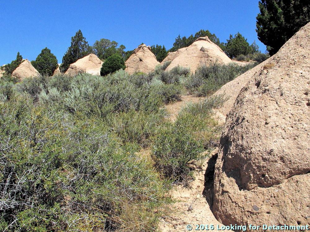
These rock formations (above and below) have an incipient tent-rock shape, with a tiny capping of a harder, more weather-resistant layer near the top. I suspect that these budding hoodoos correlate with the "tent" part of the hill we saw near Vya, where more of the geologic section was exposed.

The weathered form above is similar to some shapes one might see in weathered granite. This particular type of shape—gently rounded or sub-spheroidal—is not uncommon in some ash-flow tuff units, hence the name "granite-weathering tuff" for part of at least one regional ash-flow sheet in south-central Nevada.

Let's get closer:
Here's a fairly large, subrounded lithic fragment within the tuff.
Zooming in a bit, we see that the matrix of the tuff is fairly fine-grained, fairly well-sorted, and some grains look sharp and appear to be interlocking.
It would be fairly easy from this one photo (above) to convince oneself that the matrix was pumiceous and glassy.
Here's another view of the rock: Rounded to sub-rounded lithic fragments and white pumice float in a fine-grained matrix.
I'm pointing to one of the white pumice fragments in this enlarged view.
I had a harder time, after looking at this second example of the exposure, convincing myself that this was unwelded or poorly welded pyroclastic flow rock (ash-flow tuff—same diff). The second closeup shows scattered rounded to subangular dark-colored and white lithic fragments and fairly small to fairly large white pumice in a dirt-colored matrix of subrounded, fine-grained pebbles, lithics, or pumice and glassy-looking particles. This photo could be of a reworked tuff or a lithic-rich or lapilli tuff of unknown origin. Are the pale orange, subrounded fragments pebbly lithics or rounded pumice? If pumice, are they primary, deposited in either an air-fall or ash-flow type of environment, or have they been rounded by reworking in some type of fluvial or colluvial environment? (Your thoughts are welcome.) The two photos, the first with the large lithic and the second with the white pumice, were taken within a few feet of each other.

Standing back and looking at the overall mien of the outcrop, I'm going to have to stick with poorly welded ash-flow tuff.
I tried to find out about the geology of the area and found this one geologic map by Egger (2010), a regional map focusing largely on the Warner Range to the west but also including part of the Hays Canyon Range. According to the map and accompanying text (both are available for download here), these hoodoos and rock formations occur in what has been called the Fortynine Tuff by Carmichael et al (2006) in an article I didn't access (paywall).
I noticed (after the fact) a couple intriguing joints within the tuff, including two that might have veins of some sort or slickensides (the upper, center one in shadow, and one just below it and to the right, also in shadow).
Egger references an age of 26.26 ± 0.13 Ma (Egger, 2010; Egger and Miller, 2011) for rock just a little north of this exposure, rock included in the Fortynine Tuff of Carmichael et al (2006) and mapped as unit Tovu by Egger (2010): This tuff is Oligocene in age.

A Few References:
Carmichael, I.S.E., Lange, R.A., Hall, C.M. and Renne, P.R., 2006. Faulted and tilted Pliocene olivine-tholeiite lavas near Alturas, NE California, and their bearing on the uplift of the Warner Range [abs link]: Geological Society of America Bulletin, v. 118, no. 9-10, p. 1196-1211.

Egger, A.E., 2010, Geological history and structural evolution of the Warner Range and Surprise Valley, northwestern margin of the Basin and Range Province [Ph.D. thesis]: Stanford University, 180 p. Plate1.

Egger, A.E., and Miller, E.L., 2011, Evolution of the northwestern margin of the Basin and Range: The geology and extensional history of the Warner Range and environs, northeastern California: Geosphere, v. 7, no. 3, p. 756-773.

Tuesday, August 16, 2016

One Year Ago Today: A Short Trip on Highway 8A in northern Washoe County — and Hoodoos!

A year ago, MOH and I were out on a two-day road trip that was designed to take us to the section of old Nevada S.R. 8A that has long been rumored to still be signed, though it is no longer shown on state road maps as 8A, nor has it been since 1981. To accomplish our goal, we drove north out of Gerlach on old S.R. 34 (now Washoe County C.R. 34). It's about 85 miles from Gerlach to Vya, a small outpost consisting mostly of a Washoe County road department building or two and some private ranches.

Strangely enough, Google Maps won't let me make a connection from Gerlach to about 5 miles north of Gerlach on C.R. 34 without routing me either all the way over to Cedarville, CA, or taking me down an obscure and suspiciously narrow-looking dirt road.
The route above doesn't start in Gerlach, because it can't. The route below, starting in Gerlach, won't go exclusively on C.R. 34, because it won't.
After 3 hours of driving (driving and stopping, driving and stopping), we ended up at this junction with old 8A:
The junction of old S.R. 34 and old S.R. 8A in northern Washoe County.
At this point, we turned right to see what we might find.
An 8A sign, up ahead!
This is actually a "To 8A" sign! It's pretty well marked for a road that no longer exists, I'd say!

A little ways on, around a bend taking us back to the north, we came to another junction, one with several signs.
A small sign forest appears at the junction of conjoined 34+8A and 8A, which turns off to the east.
Here's another "To 8A" sign. Turn east just ahead.
Vya is now shown as being a mile to the north on continuing C.R. 34, and the sign says you will reach Denio or Winnemucca in many miles if you turn right.
The rest of the signs at the second junction are the back side of a yield sign, a BLM sign pointing to unreadable destinations, and a "To 34" sign beyond that.
We turn right, of course, so we will be able to say we drove onto the northern leg of old Highway 8A. Now, what do those signs say?
This is 8A. It's signed. The sign doesn't say it's a county road.
"Road not regularly maintained. Travel at your own risk. Closed during winter."
This warning sign was put in place sometime after the infamous Stolpa incident back in late 1992 – early 1993 (some links here).
There's the jeep, barely on 8A, back at the junction with 34. Oh, and look: hoodoos!
We drove north on C.R. 34 to the maintenance station at Vya. Apparently if we had driven a little farther north, we'd have been at the site of the old town of Vya, now a ghost town.
There's a good batch of hoodoos in volcanic rock on the hillside behind the maintenance station. Don't ever plan on getting gas at Vya! There isn't any!!
Having met our defined goal of reaching the northern portion of old Highway 8A, we turned back to the south. From the junction up ahead (the one we turned east on briefly), to the CA state line, we will be on old 8A, and for a short distance, also on old 34. Highway 34 wasn't even a marked road until sometime after 1939, whereas 8A was on maps as early as 1929 (a few maps and links here).
We head south on 34, which will turn into unmarked 8A (combined with 34) at the junction just ahead.
Now we've rounded that first bend and are back at our first junction. We'll head west on unmarked 8A. There may be hints of hoodoos on the far slope.
Now we've crossed over an unnamed pass in the Hays Canyon Range, and are nearing the NV-CA border.
There was a profusion of sign at the border, but no sign marking 8A going back into Nevada.
We stopped at the stateline to see if the sign that had marked 8A would still be there, but it wasn't. Gravel turned to pavement, old 8A became CA 299, and we drove on down into Surprise Valley, which wasn't looking very green a year ago today.

Tuesday, August 9, 2016

Titus Canyon: The Upper Part of Lost Canyon

As we descend the west side of Red Pass and enter the realm of Titus Canyon proper—as opposed to being just on the Titus Canyon road—the geology becomes a little more complex than the Tertiary-to-the-north–Cambrian-to-the-south scenario that we've been seeing since leaving Tan Mountain. Just for the heck of it, I’ve shown a little of the geologic complexity of the area below, although the contacts I’ve drawn, using Google Earth’s “Add Path” tool, are merely the ones I’ve felt the need to investigate during the course of writing these little blurbs about Titus Canyon: They by no means represent all the geology, nor are they guaranteed to be accurate or precise. And I’ll probably add a few more lines before we reach Titus Canyon’s alluvial fan!
Geologic contacts are in cyan and other colors; faults are thicker lines in dark blue, dark purple, and magenta. Geology is modified from Niemi (2012) and Reynolds (1974, also as seen in Lengner and Troxel, 2008).
On the last bit of our journey along the Titus Canyon road, we had stopped to briefly consider the geology of Tc Hill, and we had nearly reached the sharp turn at the western base of Red Pass. We have now fully entered the southeasternmost branch of upper Titus Canyon.

There are three branches to upper Titus Canyon. The longest branch, the northern or western, runs about 5 miles almost due south from its headwaters near Alkali Spring; this branch is labeled Titus Canyon on topo maps. The second longest branch, the southern or southeastern, runs about 2.5 miles northwest from Red Pass; though unnamed, we're calling this branch Lost Canyon after Lengner and Troxel (2008) and others. A third branch, the eastern or middle, runs about 2.4 miles southwest from headwaters in the volcanic hills near the California-Nevada border; this branch is also unnamed, and I'm not aware of any local or regional designations for it. The three branches meet just below Leadfield.
The three branches of upper Titus Canyon: The main, west or north branch, aka Titus Canyon, is in purple; the unnamed middle or east branch is in yellow; and the unnamed southeast or south branch, aka Lost Canyon, is in red.
At the western base of Red Pass, the road takes a tight curve and heads west-northwest, closely following the dry wash that cuts through this upper section of Lost Canyon. The gradually crumbling, oft-times slumping, but still-steep cliffs of colorful Tertiary beds dominate the skyline to the north. To the south, the rocks are a bit of a mishmash: Though most of the hilly slopes are underlain by several different Cambrian formations, a few irregular and nearly level reddish patches harbor the poorly exposed, lower Tertiary Titus Canyon Formation, and a batch of locally coalescing rocky knobs expose rugged masses of dark gray Tertiary megabreccia.
Beyond the gray Tertiary megabreccia immediately on our left (south), I spy the maroon color often indicative of Cambrian Zabriskie Quartzite (Cz).
Immediately ahead, the road abandons its close proximity to the wash and passes into a half-mile by quarter-mile upland plain painted red by the lower Titus Canyon Formation. It is at just about at this point in the road that I often become fascinated by the cliff to the north and have to stop to take a few more photos.
We've been calling this cliffy hill "Tc Hill" for the reddish brown formation that caps it, although we could have gone with "Tm Hill" for the Timber Mountain Group tuffs that we can't see beyond and above the upper, dark brown cliff.
This is a perfect spot to review the geology, which is basically a faulted stack of Eocene to Miocene sedimentary and volcanic units: Titus Canyon Formation (EOgtc), possible Panuga Formation (Tg?), Wahguyhe Formation (Tw), and one or two ash-flow tuff formations within the Crater Flat Group (Tc).  The contact between the Tw and the overlying Tc is unclear, but it's probably either right beneath the reddish brown cliff labeled Tc, or it's right below the uppermost, thin whitish layer just below that, or it lies below the cream to pale yellow cliffs below the whitish layer. It's too bad that contacts—which are inconstant constructs that can move with changes in stratigraphic nomenclature—aren't drawn across the land!
Tc Hill, with some geologic formations and a few contacts drawn in.
The dark cyan line between the Tg? and Tw might be one strand of the Fall Canyon Fault Zone (a more definite strand is in dark blue), or it might be a regular stratigraphic contact.
This part of the countryside reminds me of those wonderful desert paintings by Georgia O'Keeffe.
Red rocks on a pink, yellow, and green slope.
As we traverse this relatively flat area, the road will cross several rills and washes coming of the cliff to the north.

The road continues on. The contact between the lower Titus Canyon Formation and the underlying Cambrian units (that's quite an unconformity between the Cambrian and the Eocene!) is now almost immediately south of the road, between us and the main dry wash of upper Lost Canyon. As we cross several rills and washes coming off the cliff to the north, we'll pass low slopes of gray Carrara Formation and bulges of dark gray Bonanza King Formation. If we look closely, we might spot a few old workings dug into these older formations, hinting that we're getting close to the old mining camp at Leadfield.

Now, as we near the end of the reddish upland, the road swings wide and to the south, and we're suddenly aiming toward a lumpy hill of dark gray rock. This is one of several large bodies of megabreccia composed of limestone fragments and blocks (limestone and dolomite?), which lie at or near the base of the Titus Canyon Formation. Stock and Bode (1935), who described and defined the Titus Canyon Formation shortly after H. Donald Curry's discovery of a Titanothere in what became known as Titanothere Canyon (Protitanops curryinow part of the Brontothere family; read more about this story at Geotripper), included the "limestone breccia" as a basal part of the larger Titus Canyon Formation. In the many times I've driven by these breccia bodies, I've always assumed they were part of the Paleozoic section of the area! Next time...
The reddish road, pointing toward a jumble of dark gray rocks in this Google Earth ground-level view, is about to make a tight turn to the right.
This tight turn signals that we are about to descend into the Leadfield part of Lost Canyon, and that we are nigh onto the roughest part of the road.

Now that we've passed this tight curve, the road has a steep drop off to the dry wash immediately to the left. Across the wash, there's a great view of one of the larger dumps of the Leadfield mining camp.
A partly wash-eroded mine dump sits below a large, dark gray outcrop of Tertiary megabreccia. Cambrian Zabriskie Quartzite forms a maroon cliff in the upper part of the photo. 
I was a little surprised to find that the oldtimers were digging into what's long since been determined to be monolithologic breccia formed of angular clasts and blocks of Bonanza King Formation, that is, not the Bonanza King Formation itself. Although I haven't examined this working in the field, I'm going to note a few things from the photo as though I was looking at it from an exploration standpoint. First, a bit of a hedge: It's very hard to tell what the oldtimers were after without actually making a visit to the site (all I've ever done is drive by).

A first thing to note is that there is a fair amount of iron oxide on the dump—and on the rock outcrop immediately to the right of the dump, and also on the slope coming off of the Fe-oxide-barren dark gray carbonate breccia (reportedly the breccia might consist of both limestone and dolomite). The iron oxides consist of goethite, hematite, and jarosite based solely on the color seen in these photos (hopefully the color balance of the photos is good), the oxides are leaning toward goethite and jarosite. (Here, I'm using the old porphyry copper, Bear Creek–originated triad of hematite-goethite-jarosite, even though jarosite is technically a sulfate, not an iron oxide. Someday I'll have to try to do a color triangle to show what we used to use.)

Secondly, I'd like to note that someone took the time and effort to shore up the flat area in front of the adit feeding this dump with fairly cruddy hand rocking (left of the dump and best seen in my next photo).
Here you can see the dump and rock wall a little better. The adit opening is behind a largish creosote(?) bush.
Oldtimers were interested in a number of things, just like we are today. They would have been more attracted to the rocks with iron oxides, although iron oxides by themselves aren't indicative of anything besides the oxidation of iron, and iron oxides aren't necessarily all that uncommon in carbonate country. The oldtimers would have liked any quartz vein material they might have seen floating around, and they would have noticed any gossanous material that might indicate the weathering of sulfides. They also knew how to follow structures. Adits, like the one that created this mine dump, were often dug to either follow structures or to intersect them.

The biggest anomaly I see in the photo is the abrupt, semi-linear contact between the unoxidized, cliff-forming dark gray rocks and the oxide-bearing, slope-forming grayish orange rocks. It's possible that the oldtimers were trying to hit this contact. Maybe there was a little indication of "mineral" upslope, maybe not. It's a little hard to for me to imagine that this particular dump was created solely as part of a stock scam, as has often been claimed for nearly the entirety of the Leadfield camp.

That is, if I was doing any exploration in this area (I don't conduct exploration in National Parks or Monuments; it doesn't pay), I'd be remiss if I didn't take at least one sample from this dump, and if I didn't try to find something to sample either in the back or ribs at the adit opening, or on the hill above it. Maybe I'd only try to grab (select, or "high-grade") a sample of iron oxides in blebs, veinlets, or on fractures. I'd also be remiss if I didn't at least look for a "goody pile" left by the last claimholders, although erosion by the wash might have taken it away.

So much for armchair exploration! Here's a bit of the geology near the adit:
Cbl = Cambrian Bonanza King Formation (should be "Cb or Cbk"); EOgtc = Eocene to Oligocene Titus Canyon Formation; Mbx = Tertiary/Paleogene, probably Eocene megabreccia in or at the base of the EOgtc.
After rounding the next bend, we'll be descending into the lower part of Lost Canyon...into the Leadfield basin. The road is on the side of a fairly steep, rocky hill, and we come to what is probably the worst part of the road overall: the part where you might get high-centered if your clearance isn't good enough or if you hit it at the wrong angle.
The road passes over a barely scraped, overhung exposure of Tertiary megabreccia.
We descend, switch back to the south, and there's a great pullout for hiking back to the mine dump and adit we just viewed.
From this trailhead you can hike the short distance to the mine dump we just viewed, and one or two other dumps along the way.
Most mine adits and shafts don't have all these hazards, but most have a few to several. Don't go in if you don't know what you are doing, and don't assume you know what you are doing. It's my humble opinion that you don't.
Well, there we are: We've arrived in the lower part of Lost Canyon, in the valley or basin that the ghost town of Leadfield occupies.

A Few References:
Lengner, K., and Troxel, B.W., 2008, Death Valley's Titus Canyon & Leadfield ghost town: Deep Enough Press, 175 p.

Niemi, N.A., 2012, Geologic Map of the Central Grapevine Mountains, Inyo County, California, and Esmeralda and Nye Counties, Nevada: Nevada, Geological Society of America Digital Maps and Charts Series, DMC12, 1:48,000, 28 p. text.

Reynolds, M.W., 1969, Stratigraphy and structural geology of the Titus andTitanothere canyons area, Death Valley, California [Ph.D. thesis; not available online]: Berkeley, University of California, 310 p.

Reynolds, M.W., 1974, Geology of the Grapevine Mountains, Death Valley,California; a summary, in Death Valley region, California and Nevada, Geological Society of America Cordilleran Section, Field Trip 1 Guidebook: Death Valley Publishing Company, Shoshone, California, p. 91–97.

Snow, J.K., and Lux, D.R., 1999, Tectono-sequence stratigraphy of Tertiaryrocks in the Cottonwood Mountain and northern Death Valley area, Californiaand Nevada, in Wright, L.A. and Troxel, B.W. eds., Cenozoic basinsof the Death Valley region: Geological Society of America Special Paper 333, p. 17–64.

Location map

Related Posts:
The Approach to Titus Canyon: Tan Mountain
The Approach to Titus Canyon: Up and over White Pass
The Approach to Titus Canyon: To Red Pass
The Approach to Titus Canyon: Just Below Red Pass
A Hike at Red Pass, Titus Canyon Road, Death Valley, CA
Titus Canyon Road: A Little History and a Few Maps
Down into Titus Canyon: We Leave Red Pass Behind (Finally!)