Showing posts with label mirage. Show all posts

Monday, September 30, 2013

Across the West and Back Day 2: Across the Salt Lake Desert

MOH and I left Nevada and entered Utah shortly after getting back onto I-80 following our brief sojourn in West Wendover, and began crossing the Great Salt Lake Desert (and Bonneville Salt Flats).

When almost to milepost 16, I took an obligatory photo of Floating Island, no doubt named for the mirage that often makes it look like it's floating above the salt flats. Here, the mirage is minimal but present. (See better photos of Floating Island with strong mirage here.)
Floating Island.
It turns out that Floating Island *may* be at least partly underlain by our old friend, the Ely Limestone — or perhaps it's underlain by a Utah equivalent, the Lake Point Limestone, or another Utah equivalent, the Erda Formation. On the interactive online Utah state geologic map, clicking reveals that Floating Island is listed as being underlain by the Oquirrh Group (with the symbol PP - Pennsylvanian undivided?), consisting of such formations as the "Wells, Weber, Ely, Callville and other Fms" — at the same time, the map shows the symbol PPe on the northeastern side of Floating Island. PPe is the usual symbol for the Ely Limestone in eastern Nevada, but perhaps it could also refer to the Erda in Utah. For me, the island is too far away to make any snap judgements!

It was a cloudy day, overall, but nevertheless you could see a good 90 miles to the far peaks.
Looking ESE across the desert at the Cedar Mountain, and the crest of the Stansbury Mountains beyond that.
It became clear about halfway across the desert that distances were more than usually deceptive. The eastbound road markers on I-80, which begin with milepost 1 exactly one mile east of the NV-UT border, essentially mark the distance you have travelled across the desert from its western edge at just east of West Wendover, NV (in fact, you travel almost exactly a mile from the state line before ramping down onto the flats). Just before milepost 21, we passed a road sign indicating that it's 22 miles to the Knolls. The Knolls exit is just past the eastern edge of the salt flats, so I knew we were just almost exactly half way across.


View Approximate half-way point in a larger map.

It seemed like we had been driving forever! The low hills in the distance, marking the other side of the desert, only looked about 8 to 12 miles away, though they were really about 21 miles off. We knew we had another "almost forever" still left to go!
Milepost 39: Finally we were approaching the east side of the broad, flat crossing.
Exit 41, Knolls, one mile past the first sand dunes at the east edge of the desert. Milepost 40 is visible in the photo, not far beyond the exit sign.
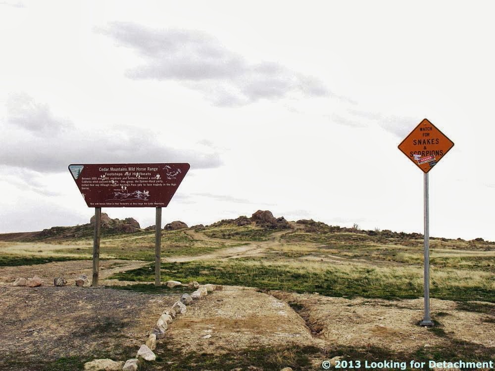
At the exit for Knolls (a siding? some hills?), we knew we were getting close to one of our favorite rest stops, Grassy Mountain. The rest stop is known for a short hiking trail and a sign saying "Watch for SNAKES and SCORPIONS."
Despite this sign, I've never seen any of either...
...although we did see a horned lark noshing on a pretzel.
More commentary has been added to a second warning sign.
The second sign says, among other things, "DANGER: Sex, Sleds, and Snowboards."
Finally, on a day perhaps as cloudy as the one shot here in 2011, we started out on a little leg-stretching expedition.
And I'll have to save the hike for another post...

Photos to this point in Day 2 have been added to the day's trip log on Google Maps, along with the ones from West Wendover, which I forgot to add after the last post:


View Day 2: Elko, NV to Vernal, UT in a larger map.

Related Posts:
Across the West and Back Day 2: A Side Trip in West Wendover
Across the West and Back Day 2: Pequop Summit to West Wendover
Across the West and Back Day 2: Looking for an Old Roadcut
Across the West and Back: The First Day
Intro to Recent Western Loop Trip

Monday, August 6, 2012

Smoke in the Black Rock & Smoke Creek Deserts

Smoke over the Black Rock Desert, as seen from the east on the Jungo Road. Smoke is probably from the Salt Fire north of Redding.
Smoke over the Smoke Creek Desert, as seen from the southwest part of the Black Rock Desert looking toward Gerlach. Smoke is from the Chips fire near Belden and Caribou, CA, and the Peak fire in the mountains southwest of Milford, CA.
Smoke over the Black Rock Desert, as seen from Coyote Spring Dune (MSRMaps location, Google Maps location), looking east toward Trego Hot Springs.
Smoke over the Smoke Creek Desert southwest of Gerlach, as seen from Coyote Spring Dune. Newish jeep for scale.
Mirage on the Black Rock Desert, looking southwest toward Gerlach, the green patch or oasis in the middle ground, and at smoke beyond the peaks of the Fox Range in the background.
Smoke over the southern Smoke Creek Desert, looking south from a point on the Smoke Creek Desert Road, about four miles nearly due south of the mouth of Five Springs Canyon and about four miles southeast of Granite Spring. The darker hills on the left are in the Fox Range near Reynard siding; the lighter hills behind them are in the Fox Range near Wild Horse, Pole, and Rough Canyons.
Another shot from the same angle, with a thin mirage on the desert (click to enlarge). The farther pale blue hills beyond the ones near Wild Horse Canyon, et al, include low hills near Sano siding and Emerson Pass, the Terraced Hills just north of Pyramid Lake, and the Virginia Mountains on the west side of Pyramid Lake.

Photos are from 3Aug2012.

Saturday, February 18, 2012

Mirage Links

This post at Earth Science Picture of the Day (EPOD) got me started.

Mirage - Wikipedia

An Introduction to Mirages - Andrew Young at SDSU: links, explanations, and many more pages

Mirages & Refraction - Atmospheric Optics

Superior Mirage - NSIDC

Inferior Mirage - Polar Image

Highway Mirage - EPOD

Green Flash - Atmospheric Optics: also see the subsections

An Introduction to Green Flashes - Andrew Young at SDSU: links, explanations, and many more pages

Green Flashes at a Glance - Andrew Young at SDSU: a few basics

Green-flash Fallacies and Misconceptions - Andrew Young at SDSU

Pictures of Green Flashes - Andrew Young at SDSU: links to pictures and much more

Green Flash Simulations - Andrew Young at SDSU: links to the simulations are near the bottom of the page under What's available

Mirage here at LFD

Wednesday, April 20, 2011

Mirage on the Desert

The bluish Bovine Mountains about 8 miles north of I-80 and, to the far right, the white, snowy Mount Harrison, a 9265 foot-high peak in Idaho, more than 60 miles north of Interstate 80 ... all behind the much closer Floating Island ... as seen across the mirage of the Great Salt Lake Desert, April 3, 2011.

When crossing the Salt Lake Desert from east to west, as came to pass on both trip one and trip two, we eventually came to the place where the salt flats to the north are not blocked by dikes of dirt or water control bars along I-80. The dikes disappear less than two and a half miles east of the northern rest stop near the Salduro railroad siding. At that point, uninhibited views of the vast desert appear, and any mirage that has formed becomes completely visible, unblocked by the previous water control bars.

I've never seen the desert without at least a thin mirage.
Mirage: not only does it appear that you can see water or sky beneath the dark, semi-detached island, but a thin white line floats across just left of center and just beneath the dark island, crudely marking the top of the playa surface (click to enlarge).
Floating Island (right) begins to detach from the Silver Island Mountains (left).
The white mountains to the right of Floating Island in this photo are the Raft River Mountains (of core complex and detachment fame).

The mirage of the desert causes the islands, large and small, to become like Rorschach tests, changing constantly with the lighting and the change in view angle resulting from our 70 mph speed. An appropriate name: Floating Island appears to float away from the Silver Island Mountains as you drive east to west; it also appears to float above the playa surface.
Floating Island can be seen clearly from the northern of the two Salduro siding rest stops. The dark line across the playa, above the white band where the sun is lighting up the ground, is probably a water bar, dike, or raised road protecting either the northern rest stop or the Bonneville Salt Flats racing area (the curved dike on MSRMaps). The apparent height of the dike may be enhanced by mild mirage, and some apparent lack of view of the lower part of Floating Island may be due to the curvature of the earth across 2.5 miles. The theoretical horizon distance for a short person like me is about 2.7 miles without considering refraction, and about 2.9 to 2 miles with a "normal" amount of refraction and no mirage, which will extend how far a person can see. Read more here.
Mirage and Floating Island pictures are all from April 3, 2011.

Related Posts:
Salt from Bonneville Salt Flats
A Tale of Two Trips

Last updated April 26, 2011. Corrections made to properly identify mountains in the distance.

Friday, July 2, 2010

Recent Road Trip on 8A: Agoraphobia?

water
Water in the desert at 12:30 pm: Seyler Reservoir, looking north up Big Smoky Valley.

I took a road trip last week, south into Big Smoky Valley (MSRMaps), in order to grab a few photos from areas I visited in 1976 while on my thesis hunt.

I started fairly early in the morning while the weather was surprisingly cool — though the day warmed towards summer as the road dropped elevation to the south. I stopped for lunch at Carver's Station (sometimes called Carver's, or even Carvers), after making a brief run up Kingston Canyon to look at a cabin I used to stay in way back when. (It's still there, a different color, but still there.)

The trek from the Peavine Campground turnoff to the Pole Line Road, and then back again, on varying types of dirt roads — all the while making assorted turnarounds to check things out and to, well, turn around — took about two hours. (See my Pole Line to Belmont post for the route.)
mirage3
Mirage in Big Smoky Valley, looking north from about San Antone Ranch, at 2:30 pm.

I had started out the day feeling anxious, agitated, or rushed — though sometimes merely intent and interested — and I went in and out of these various phases as I zoomed down Big Smoky Valley, actually achieving nearly laid-back feelings during lunch repasting. I kept thinking that the agitation and anxiety might be echoing the way I felt back then, back in '76, when I took off down roads I'd never seen before and went to places I'd only heard of.
smoky
Big, wide Big Smoky Valley looking north, also at about 2:30 pm.

I'm not sure why I was feeling that way last week while driving roads I'd been on and going to places I'd been to (although some places I hadn't seen in a couple or three decades). It felt a little like overdrive, like I had decided to try to get it all done in one day, therefore I had a deadline and had to rush to meet it. It also felt like agoraphobia: the wide, open, bright blue sky getting larger and brighter the farther south I went and the longer I stayed on the road. I'm sure that banging up and down and across bright beige, washboardy to nearly washed out roads didn't really help matters. I barely stopped anywhere for photos; took most of them on the run.
toiyabe1
A closer view of the east side of the southern Toiyabe Range.

I realized later that I'm better off going somewhere — some place, a pre-identified, pre-chosen place — arriving there in the mid to late afternoon or early evening, getting a room (yes, that's right, a motel room, not a camp spot for my truck). Settling in calms me down from any overdrive or hyper-roadness I've accumulated while being wired for driving; I can walk around, get some dinner, have a beer (or not, as the case may be), sit in an air-conditioned room (rather than running through the summery desert and steppe in a hot, non-AC truck), and chill. That way, the next morning I can calmly — after breakfast, and after getting some lunch fixings — get in my truck and drive to a few specified (or even impromptu) areas or roads or towns or whathaveyou.
toiyabe2
The same mountains at about 4:30 pm, from just north of the Manhattan turnoff.

Anyway, the glaring, not-yet summer-hot sun can be a detractor while trying to remain calm in desert conditions, and wide-open spaces can be counteracted by spending a couple days indoors doing paperwork or staring at a wall. They can also be relieved by days spent in amongst trees, even those as small as found in a typical piñon-juniper forest. Tall trees are even better. Tall trees and cool water.
ranch
A cool-looking ranch on the range-front at Pablo Canyon.

Hmm... what am I doing here? Well, it would be a 16-hour round trip and about $120 in gas just to escape to the lake for the weekend. Or, it could be a similarly long round trip and about $??? in an airplane to get away to that cool north country known as Alaska.

(Oh. And on the way back, before even making it to Carver's Station, the battery gauge started reading lower, and lower, and lower, and... )

Sunday, March 29, 2009

Honey Lake Update: Dust, Rain, and Water

While out driving around last week, I stopped at the Honey Lake Rest Area on Highway 395 between Reno and Susanville, and watched a dust storm, with scattered dust devils, on the Honey Lake playa. Honey Lake is shown on this map and photos as a lake, but it isn't much of a lake these days.
It was a dark and stormy day, and one particular dust storm arose, grew, whirled a bit, and dissipated while I watched. The photos of this storm were taken looking a little north of east from the rest area.
The Skeddadle and Amedee Mountains form the backdrop for this particular dust storm.
Here, the dust storm does a bit of whirling, forming a wide-diameter dust devil, prior to dissipating.
While the dust storm gets smaller, a vaguely funnel-shaped cloud forms above it. This cloud is probably not a funnel cloud, though I have seen small funnel clouds above large dust devils.
Now the dust storm is getting thinner and thinner, dwindling while I stand in the rain, getting wetter and wetter.
Meanwhile, a bit to the south, some classic dust devils arise in the desert mirage.
My favorite mirage-based dust devil of the day.
cloud1 The clouds above the larger dust storm formed interesting shapes, especially as the dust storm was winding down. Here are a couple enlargements of the cloud shapes.
cloud2
raven On the next day, the storm - wind and rain - was mostly gone, the playa was wetter, and vultures flew back and forth in front of me.
A little farther south, in the southwest arm of Honey Lake, I spotted some water in the lake (enlarge and look closely!).
The water was south of The Island, almost lapping up against a landform I sometimes call "the bluff." I'm always a bit happier when I can spot some water in Honey Lake.