Showing posts with label mapping. Show all posts

Tuesday, April 5, 2016

Death Valley Trip, Getting There: A Jeep Trail, Folds and Cartoons of Folds, Even More Folds, and Boundary Peak

An unnamed portion of the Gabbs Valley Range.
From the vantage point of the end of the last post, a little southwest of Luning, Nevada, I turned around and pointed my camera northeast across Soda Spring Valley ... and paused to think back to the late 1980s, when we in the Western District of Former Mining Company had finally taken over exploration of the Walker Lane, which until then had been a mostly unexplored part of the Nevada District. We drove all the roads in the area—up canyons, over ridges, and across saddles—and one thing I remember in particular was coming over the top of a low ridgeline from the east, on a jeep trail that dived and went into a series of moderately sharp switchbacks as it approached some old mine workings.
The road in question is below the arrow.
Ah yes, the memories. We found a gold-bearing skarn—it's not quite in view in the photo above—and after some sampling and sketch mapping, we debated targeting some drill holes, but decided it was too small for our target size.

Back to the road itself. Coming over the top from the east (something I'm not likely to do in any near future that I am aware of), the road immediately drops and dives around a curve, making it hard to judge the condition of the road ahead. We maneuvered to some particular point and stopped. What the H! We would have to do a bunch of walking to actually explore the area anyway, so maybe it would be better to stop here at this turn-around spot than to go farther and find that the road requires backing up on steep slopes around sharp turns.

I don't really remember how we handled the sampling logistics. Sometimes it's easiest to drop a couple people off near the top and then meet them at the bottom later in the day, after they've sampled the upper slopes and you've sampled the prospects in the lower hills. Or maybe after a bit of walking around, we found the road acceptable and drove on down.
The road as seen in Google Earth. It's downhill to the lower left (SW).
The Google Earth view of the road is somewhat impressive *in* Google Earth; here's the Google Maps link in case you want to find it on Google Earth.

The view from the upper part of the jeep trail was grand. I've tried below to simulate the view by sloppily stitching together two Google Earth images:
Walker Lake is off in the upper right (W), Luning is just left of center on the other side of the beige plain (SW); Mina is out of the picture to the left (S). 
After grabbing the first shot or two, I pointed my camera more to the east—a little north of east, to be precise—at a folded part of the Gabbs Valley Range, another area we explored back in the late 1980s.
The notable landmark of this part of the Gabbs Valley Range is a dark pimple of a peak to the right of center: Volcano Peak.
Volcano Peak is not a volcano; rather, it is underlain by tilted beds of the Upper Triassic Luning Formation, which consists mostly of limestone, dolomite, and shale.
Zooming in, we get a better view of Volcano Peak and can identify a few old porphyry copper drill roads that probably date back to the 1960s or 70s.
In a similar Google Earth view, we can begin to see a fold nose, centered and just above the dark line (a Google Earth artifact).
I've cropped this image so I could zoom in farther. The upper drill roads are more apparent. Volcano Peak is now on the far right.
It can be fun to take a shot at the geology by drawing lines on photos like these, or on air photos. Drawing without checking the geology first can be chancy, if one is concerned about being right, as can drawing without checking the geology in the field afterward.

Before checking the geology, I came up with the following cartoon, wherein I assumed many features to be stratigraphic beds, and assigned a few other features to faulting.
Here's my first cartoon, with presumed bedding in cyan and a few tentative high-angle faults in dark purplish blue.
I wondered if the central dashed line across the first cartoon was a low-angle fault of some kind.

After concocting the first cartoon, I checked out the geology as mapped by Ekren and Byers in 1985. It turns out that I missed a large blob of quartz monzonite (mapped as JKqm).
The quartz monzonite is outlined in red.
The central line, which was dashed in cyan in the first cartoon, has now been drawn in dark blue, a mapped fault. It's a high-angle fault, however, and it's just our angle of viewing that makes it look horizontal. (Here we can see why apparent dip matters so much: from this angle, the dip looks to be nearly zero; in reality, it is closer to 90 degrees, although that's a guess, as there is no measurement of it on the geologic map.) The quartz monzonite is cut by this high-angle fault, which is down-to-the east, dipping eastward away from us. I left in the cyan bedding emphasizing the fold, and I left in my still tentative high-angle faults in dark purplish blue (toward the right).

These two cartoons show the problem with assuming too much from photos (or air photos). Features that look like bedding might, when field checked, actually be faults, dikes, or other structures like joints. In this when case, we checked the cartoon against a geologic map of relatively small scale, 1:48,000 or 1 inch = 4000 feet.

Somewhere in these canyons, way back in the late 1980s, we came across an old, partly broken-down core shed. The shed was mostly intact then, but the core had started to become scattered, either from vandalism or from the escalating disintegration of the core boxes (or both).


By this time on our trip to Death Valley, it seemed that we should be farther along, but we hadn't even gotten to Tonopah! So we moved on, but almost immediately we decided to stop not far down the road: it was getting to be lunchtime. Just before Mina, we pulled off the highway onto a major dirt road that goes eastward between the Gabbs Valley Range and the Pilot Mountains.
Looking southeast toward the Pilot Mountains from a broad alluvial plain above the town of Mina. Pilot Peak is hidden from view behind the unnamed, lightly snow-dusted, >8500-foot-high peak.
A lot of folding, thrusting, and possibly some low-angle normal faulting has occurred in the Pilot Mountains. In fact, the area is (or should be) one of the type localities for the Luning-Fencemaker fold-and-thrust belt.

While eating a cheese-bologna sandwich, I took a few photos of some of the folds. Some recumbent folds are actually better viewed from another road, but I forgot about that until looking around in Google Earth.
Folds! This is probably mostly Luning Formation limestone and shale, with some Tertiary volcanic rock in the lower left.
More folds!!
The potential here for great fold photos only increases with time spent in the area, and driving up into the hills would do the same.
I turned away from the folds to take this shot of Boundary Peak.
I grabbed this photo of Boundary Peak, hoping that MOH and I would get even closer later in the trip (and we did!). The photo shows both Boundary Peak (the highest peak in Nevada) and the higher Montgomery Peak, which is right behind it and slightly to the right in this photo—look carefully!

We'll continue our journey after lunch. We'll be stopping at Redlich and the Boss Mine. We'll see desert pavement and a cholla. We'll see Boundary Peak again. We might spy some breccia and a solar power plant.

Location map

Related Posts (in order of posting):
Death Valley, "Super" Blooms, Turtlebacks, and Detachments
Death Valley Trip, Part 2: More of the Badwater Turtleback Fault
Death Valley Trip, Part 3: Northward, and over Daylight Pass
Death Valley Trip, Getting There: Wave Clouds beyond the Sierra
Death Valley Trip, Getting There: A Hike to Pleistocene Shorelines
Death Valley Trip, Getting There: Walker Lake, Road Stories, A Bit about Copper, and Some Folds near Luning

Tuesday, March 29, 2016

Death Valley Trip, Getting There: Walker Lake, Road Stories, A Bit about Copper, and Some Folds near Luning

MOH and I left the area where we had stopped to hike (shorelines, remember?), and we steered steadily south—south to south by east—between the steep eastern face of the Wassuk Range and Walker Lake's western shore.

It can be hard to drive by Walker Lake without stopping for photographs, though I find myself doing that more often than not. Sometimes the lighting is off, with the sun high in the sky or at the wrong angle, other times the lake and mountains are obscured by a pervasive haze. Consequently I have few good photos of the lake. I got lucky in the spring of 2008.
Between a rock and a guardrail: the steep eastern side of the Wassuk Range, looking north along Highway 95.
I've always found this precipitous range front fascinating when driving past at 40 to 60 mph (o_O)—the granitic rocks along the range front look shattered, presumably munched by the Wassuk Range fault zone—but I've rarely pulled over to examine anything closely because of unusually minimal standing room on the inboard side of the highway.
Looking south toward Hawthorne from a pullout near what is now the north end of Walker Lake.
A strangely stitched agglomeration of six photos. Notice the pronounced shorelines in the foreground and in the distance on the left.
Driving toward Hawthorne, I had hoped to skirt town by breezing through on the hazardous waste bypass road, but our gas gauge read low enough to make me wonder if we would make Tonopah. I suspected there would be no open gas stations between Hawthorne and Tonopah. (It turned out that there weren't any, open or not!)

The first station we stopped at in Hawthorne was immediately frustrating for some reason, so I went to another station. The second station seemed to be still residing in the dark ages, without usable card readers, so I went inside. "Do you want to fill up? Leave your card here," the attendant said with her hand out. I looked at her like I'd never heard of such an archaic procedure, and she relented, "Go ahead, take it with you, just be sure to pay after." I filled up and went back in to pay. She apologized for the inconvenience, but I wasn't convinced that their card readers were actually broken. I thought it was at least 50-50 that the station was just trying to get customers inside to buy a drink or a snack or two. But maybe the out-of-order signs were legit...

For some reason I found the whole having-to-stop-in-Hawthorne situation just almost too much to handle, even though the city used to make you drive into town no matter what. Now there is a bypass. Then there was a great little Shell station at the downtown corner where you turned left after stopping at the town's single red light. It was a perfect opportunity to get excellent gas.

We pulled back onto the 4-lane part of Highway 95 near the west edge of Hawthorne and turned right onto the bypass.


Two things come to mind when I go through Hawthorne. First, I'll remember a dream I had once where I took the Hawthorne bypass and drove around town, north to south, and the bypass itself seemed to be the whole point of the dream. Second, after turning east onto Highway 95 at the south end of the bypass, my mind will go into a driving reverie and take me back to a time in the late 80s. I was telling someone that if I had enough money, I would quit my work in minerals exploration and just go out and map. Here or there. I'd seen a lot of places I thought were interesting, and I loved mapping. So, I'd just go out and map. And I'd start a map publishing company.

My unnamed sidekick said that mapping should have a point. Like I shouldn't just go out and map; maybe instead I should try to figure out something in particular about the geology of the area. I disagreed. The USGS mapped tons of quads and the whole point was getting the entire area (the West? the U.S.?) mapped. My mapping would be more detailed than quad mapping, and I would just go out and do it. Maybe I'd start right there—up ahead in the volcanic rocks near the pass outside of Luning. Maybe I'd start at any of several places I'd already done some detailed mapping, part of the point being to make the mapping available to the general population of geologists working in the area, not just to one exploration company.
Volcanic rocks in the Benton Spring area of the Gabbs Valley Range, about 7 miles north of Luning.
I drive east, my mind goes into this same reverie, and I remember that time—and how, when it came down to it and I had some money and some free time, I didn't do that.


MOH and I drove into Luning, and rather than stop at the Luning Rest Area, we took a dirt road going toward the hills of Black Dyke Mountain, accidentally choosing a road that would have eventually delivered us to the Blue Ribbon Mine. It was in this area that I learned how to test for the presence of copper in black Mn-oxides by using cold, dilute HCl to plate copper onto a rock hammer. This method tests for copper wad or neotocite (a hydrated Mn-silicate sometimes containing enough Cu to be considered an ore mineral), or a few other black copper minerals such as chalcocite and tenorite.

Not too far ahead, in the low hills of Black Dyke Mountain, we spotted some folds in unknown rock formations:
Folded, contorted rocks in the hills less than 2 miles SW of Luning.
Zooming in on the folds.
And that's it for this part of the road trip! We'll continue on towards Tonopah and Beatty next time.

Location map

Related Posts (in order of posting):
Death Valley, "Super" Blooms, Turtlebacks, and Detachments
Death Valley Trip, Part 2: More of the Badwater Turtleback Fault
Death Valley Trip, Part 3: Northward, and over Daylight Pass
Death Valley Trip, Getting There: Wave Clouds beyond the Sierra
Death Valley Trip, Getting There: A Hike to Pleistocene Shorelines

Tuesday, November 24, 2015

Views from Glass Mountain

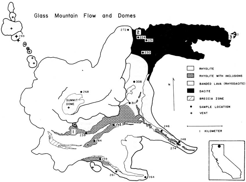
After we finally arrived at our chosen overlook part way up Glass Mountain, we milled about a bit (it was a geology field trip, after all), and then we gathered 'round a map that one of our tour leaders, Julie Donnelly-Nolan, had placed on the ground.

Above, my rock hammer is in front of blocks of relatively light-colored, vesiculated, rhyolite obsidian (AKA pumice, but in this case it's pumiceous flow-rock, not tephra).


Before I get to a few views of the area, I'll go into the geology just a little:
Julie Donnelly-Nolan points to her map of the Glass Mountain dacite-rhyolite flow, Siskiyou County, CA.
The map, not included as part of our field guide packet (Coyner, 2015), was created by Julie, a geologist for the USGS. She's been working in the area for many years. The map is similar to a map by Eichelberger (1981), which he published in an article about magma mixing at Glass Mountain, an article that is part of a larger field guide to several volcanic areas in Idaho, Oregon, and northern California (Johnston and Donnelly-Nolan, 1981). The road log for the Glass Mountain part of our GSN trip was taken in large part from the Medicine Lake Highland road log section of that larger field guide (Donnelly-Nolan et al., 1981). If you check out the guidebook, be sure to read Wes Hildreth's tribute to David A. Johnston, who died at Mt. St. Helens in 1980. The 1981 field guide was published after his death.

As you can see below in a rotated version of the map, the Glass Mountain dacite-rhyolite flow "consists of three dacitic eastern lobes which grade westward to rhyolite and are overlain by rhyolite lobes" (Donnelly-Nolan et al., 1981, and in Coyner, 2015). Well, maybe not all of that is obvious at first glance, but read on.
Map showing the silica content of different parts of the Glass Mountain dacite-rhyolite flow (Donnelly-Nolan, unpublished). North is up.
During the rest of this post, I'll be referring to the dacite flow lobe (purple, in the northeast), the rhyodacite flow lobe (red with a central ribbon of orange, in the southeast), and the south flow lobe (mixed orange, red, and purple, in the south to southeast). I'll also mention the rhyolite flow lobe (the central and northern orange area, including a well-definable flow and central dome area with margins that overlap the slightly older dacite and rhyodacite lobes), and the mixed area centered between the dacite and rhyodacite lobes.

On the map, the highest silica parts of the flow, the rhyolite, are in orange; the parts of the flow with lowest silica content, the dacite, are in purple; the areas with silica content in between rhyolite and dacite, essentially rhyodacite, are in red. NOTE: Though by many classification schemes the silica content of rhyolite is about 68 or 69% and higher (the USGS appears to be using two different cutoffs), and the silica content of dacite ranges from about 63-68% or 69%; TAS diagrams show dacite compositions as high as 72-75% (depending on what version of TAS one happens to choose; here's one; TAS explained here and here; and a lot more about the classification of igneous rocks—including all kinds of diagrams, references, and a flow chart—can be perused here). Rhyodacite is a term generally used for rock composisitons between rhyolite and dacite (USGS, OSU), rather than a specific field in most classification systems.

The colorful map (I love color!) shows that the lithologic composition of the overall flow, which is thought to have erupted during the course of several or many days or weeks rather than over several months or years, is quite variable. The complexities of magma mixing and eruption to produce this variability are described by Eichelberger (1975, 1981). Basically, it's complicated: first, basalt intrudes a rhyolite magma chamber; then mixing creates rhyodacite and dacite, which float to the top of the chamber in his eruption scenario; eruption, triggered by the mixing, produces dacite, then rhyodacite, then rhyolite.

Below, I decided to see what kind of map I would come up with going mostly by color and topographic expression of the flows (with a lot of help from Julie's map).
Google Earth image of the Glass Mountain dacite-rhyolite flow.
Here, I've delineated the dark areas with purple lines, the light, viscous, and some banded areas with orange lines, and the in between areas with red lines.
You can see that there are several areas where the lines I've drawn could be moved around, for example some of the banded areas: do they belong properly in our red or orange category?
I've added some colorful fill to facilitate comparison to the geologic map.
Here's the rotated map again (and it's skewed).
My "map" or cartoon as drawn on the Google Earth image is comparable to the rotated geological/compositional map (yay!); but really, this was just an inconsequential exercise, one that could have easily produced a considerably different map, possibly by using as many as 5 major fields (for example, if the banded-looking areas were picked out separately, and with the upper, well-defined rhyolite flow that heads off to the northeast drawn as a separate unit). Without chemistry or an already existing geologic map, this is the sort of exercise that could be done prior to heading into the field, giving the mapper an idea what to check out, although just taking an aerial image or air-photo into the field would serve the same purpose.


Well, that was really a kind of long aside, almost like a post within a post!

Besides hanging around the map and hefting large rocks, the view from the east side of the rhyolite flow (see our location below the post) was good—not great simply because of the low-hanging clouds that hadn't lifted.
Photo looking south.
I thought I might have the actual top of Glass Mountain in this photo, way over to the right, but the dome-shaped peak was covered with clouds. Instead, we can see the steep face of the rhyolite flow where it abuts a highly mixed part of the flow: the central section between the rhyodacite and dacite flow lobes (see map above).
Photo looking nearly due east.
This view looks out across the dacite flow lobe (dark brown and mostly in shadow past the light-colored rhyolite blocks in the foreground). Timber Mountain, the circular, gently sloped mountain dead center in the distance, is shown to be underlain by the the "older basaltic andesite of Timber Mountain" on Sheet 2 of this map (Donnelly-Nolan, 2010). It has been dated at 1.820±0.042 Ma, i.e., late Pliocene.

Oh, and btw, the Glass Mountain flow erupted about 900 years ago: it has a calibrated radiocarbon age of 890 BP (Donnelly-Nolan et al., 2007).
With the blocky rocks of the dacite flow lobe in the foreground, we look northeasterly in this photo. That's probably Double Head Mountain just left of center; the north edge of Timber Mountain is on the far right.
And now, we've already started back down. I'll have a few more photos along in a while...

A Few References:
A Web Browser Flow Chart for the Classification of Igneous Rocks - a lot of info (largely from Le Bas and Streckeisen, 1999, and other related sources), and a flow chart

Tephra and Volcaniclastic Rocks - good overall classification scheme, though it doesn't reference any primary sources, and allows agglutinate to occur only in basaltic rocks

Coyner, Alan (ed.), 2015, Geological Society of Nevada 2015 fall field trip guidebook: Geology of the Far Northwestern Great Basin: Quartz Mountain gold deposit, Oregon, and Lava Beds National Monument and Glass Mountain Pumice Deposit, California [for sale here, but not yet listed]: Geological Society of Nevada, Special Publication No. 60, 71 p.

Donnelly-Nolan, J. M., 2010, Geologic map of Medicine Lake Volcano, Northern California: U.S. Geological Survey Scientific Investigations Map 2927, scale 1:50,000, Sheet 1 and Sheet 2, Pamphlet to accompany the map, 48p.

Donnelly-Nolan, J.M., Ciancanelli, E.V., Eichelberger, J.C., Fink, J.H., Heiken, Grant, 1981, Roadlog for field trip to Medicine Lake Highlandin Johnson, D., and Donnelly-Nolan, J., eds., Guides to some volcanic terranes in Washington, Idaho, Oregon, and northern California: U.S. Geological Survey Circular 838, p. 141–149.

Donnelly-Nolan, J. M., Nathenson, M., Champion, D. E., Ramsey, D. W., Lowenstern, J. B. & Ewert, J. W., 2007, Volcano hazards assessment for Medicine Lake Volcano, Northern California: U.S.Geological Survey Scientific Investigations Report, 2007-5174-A, 26 p

Eichelberger, J.C., 1975, Origin of andesite and dacite: Evidence of mixing at Glass Mountain in California and at other circum-Pacific volcanoes: Geological Society America Bulletin 86, v. 10, p 1381-1391.

Eichelberger, J.C., 1981, Mechanism of magma mixing at Glass Mountain, Medicine Lake Highland volcano, California, in Johnson, D., and Donnelly-Nolan, J., eds., Guides to some volcanic terranes in Washington, Idaho, Oregon, and northern California: U.S. Geological Survey Circular 838, p. 183-189.
jpg of lava chemistry figure (Eichelberger, 1981)

Hildreth, Wes, 1981, David Alexander Johnston, 1949-1980in Johnson, D., and Donnelly-Nolan, J., eds., Guides to some volcanic terranes in Washington, Idaho, Oregon, and northern California: U.S. Geological Survey Circular 838, p. viii-x.

Johnston, D.A., and Donnelly-Nolan, J.M., 1981, Guides to Some Volcanic Terranes in Washington, Idaho, Oregon, and Northern California [pdf version; also here in html]: U.S. Geological Survey Circular 838, 189 p.

Monday, October 14, 2013

Earth Science Week 2013

Earth Science Week, organized yearly since 1998 by AGI, began yesterday. This year's theme, "Mapping Our World," is designed to highlight "the many exciting uses of maps and mapping technologies in the geosciences."

For my small part this year, I noticed a map at ESW that shows links to a Google Maps map showing earth science organizations for each state. The one for Nevada, for example, can be seen here.

I went a little bit farther and added each organization and location on the map (generated originally by user ESW, Earth Science Week) to a map of my own, to which I added a few other organizations. That map is embedded below.


View Nevada Geological Organizations in a larger map

I was working on this post last week, when at some point my computer or browser or both went into overload or freezing mode, and I had to reboot, somehow losing the draft of the post in the process. I had added only a few Nevada geological organizations to my embedded map; all the ones I added consist entirely of statewide and chapter meeting places of the Geological Society of Nevada.

The GSN website has a large number of geological links — to state, U.S., Canadian, and other foreign geological surveys, to various professional organizations, and to various State of Nevada departments and divisions. You will also find many other geological links, including several for the USGS. I had started to add the location of the USGS Nevada district office to my map, when I realized my small but increasingly time consuming project had been put in jeopardy by the U.S. government #shutdown. I couldn't find out where the district office in Nevada is located! (The district office referred to may be the USGS Nevada Water Science Center office in Carson City rather than a geologic field office, not sure.) Instead of the website linked to at this URL, I got the main USGS page and the following announcement:

Current USGS main page, retrieved 14Oct2013.
In any case, check out the other geological links at the GSN. And check out their interactive map showing locations in Nevada where their publications (mostly field trip guides from the many GSN symposia and biannual to yearly field trips.

Friday, March 15, 2013

Repost: Blackhawk landslide, California - from Pathological Geomorphology

This article was originally posted at the soon-to-be-defunct Posterous.com site, Pathological Geomorphology, and was transferred here (thanks Kyle!) to the active Pathological Geomorphology (Tumblr). My original post was a response and addition to Callan's Blackhawk landslide post on Posterous, which is now here on the Tumblr site. I've transferred the original photos, added captions, and added a Google Maps location link at the bottom. I've added the original comments (with soon-to-be-dead links to Posterous) at the bottom. Also see this related post here on LFD.


I'm posting a few additional views of the Blackhawk Landslide in California, to emphasize the truly pathological geomorphology of the area. In the views showing slide toe and slide source, I've moved the source area farther into the mountain from the original given by San Diego State [dead (kmz) link originally sourced here]. I've done this based on prior knowledge and published maps. Basically, the entire steep northern face of Blackhawk Mountain is the slide source area.
Google Earth view showing the slide source and slide toe.
Google Earth view looking from above the toe toward the source.
Google Earth view looking from above the source toward the toe.
Additionally, there are other older landslides in the area, most notably the one sometimes called the Silver Reef landslide, which is just east of the Blackhawk. Also, many additional breccias and possible landslide deposits have been mapped in the area. The geologic maps (Big Bear City quad and Cougar Buttes quad) are really awesome, especially if you know how complex the geology really is. There are numerous thrusts from the south, placing brecciated rocks of multiple ages on usually older rocks. In at least one place, bedrock has been pushed over one of the older breccias. Or is it really bedrock?

Back in the 1980's, I mapped a large area of Blackhawk Mountain and surrounding areas at 1inch = 500 feet. I found, and so have others working in the nearby northern slopes of the San Bernardino Mountains, that if you start at the top, clearly in bedrock, sometimes brecciated, and map down, then you will be tempted to map bedrock until you are clearly in landslide debris. If you start from the top and map up, the opposite is likely to happen.
Google Earth aerial view.
Aerial view with annotated geology.
The reason for northward thrusting is the bend in the San Andreas fault, causing the westward, southward side to be pushed northward, breaking over the steepened San Bernardino Mountains in low-angle faults. The thrusts cause brecciation, and the steepening, brecciation, and low-angle faulting predisposes the area to massive sliding. Stratigraphy is somewhat retained in the slides, and gold has been mined from nicely pre-broken landslid rock of the Blackhawk Slide. Silver occurs in somewhat disturbed veins in the Silver Reef Slide.

In the annotated view, the Younger LS deposits (yellow) are Holocene or late Pleistocene; the Older LS deposists (turquoise and pink) are middle or early Pleistocene; the Moderately Old LS deposits (purple and orange) are middle or early Pleistocene; the very old debris flow fan deposit (purple) is middle or early Pleistocene; and the QT Breccias (blue and red) are Pleistocene or Pliocene.


Lockwood DeWitt responded:
Lockwood DeWitt
Nice! The annotated map/image at the end really help clarify the messyness of interpretation here.
Silver Fox responded:
Silver Fox
And it doesn't even show the really screwed up bedrock!
Katharine North responded:
Great images, Silver Fox! I'm going back and forth between the annotated image and the non-annotated ones, looking at the landscape differently each time, picking out the details. I like your note about the effect of where you start mapping - good to remember!

Friday, October 19, 2012

Geologic Map Day

As part of Earth Science Week, today is Geologic Map Day!

Long before I became a geologist, I had already developed a love of maps, a love dating back to a cross-country trip I took with my family when I was five. Besides the road maps we traveled with, I had a large wall map of the U.S., on which I kept track of the states I had visited and the roads that had taken me there—these were the major highways of the day, like U.S. Highway 40, now replaced by I-80 in most places. As time went on, I learned more about other types of maps, in part thanks to National Geographic, and eventually, maybe in high school, learned how to read topographic maps and came to know the basics of reading a geologic map.

I got my first real taste of geologic mapping at field camp. I found it fairly challenging: I was still getting up to speed on the tools in use—simple tools like a quadrant-based Brunton compass—and I was also becoming gradually familiar with following contacts up and down and around hills, and across broad and hot expanses, mostly of desert.

Geologic mapping really became fun for me on our second mapping project during the summer of 1978 (several early stories are listed here), when I found that I could do it well and that a good geologic map tells a story about what has taken place in an area during past geologic times. I learned then that preconceived ideas about how the geology of an area might be such and such, accompanied by ideas that certain processes or events couldn't have taken place, or that others must have taken place, often didn't fit with the story the rocks were trying to tell me.

As geologic mappers, we must follow the contacts, over hill and dale as necessary; we must check out, ascertain, and describe the textures and rock types; we must follow basic geologic principles, while observing obvious signs and vague hints in the rocks that point to the order of events as shown by the principles of superposition and cross-cutting relationships. If the rocks are telling us something unexpected—or something thought to be unlikely or even impossible—we must listen to them. For myself, geologic mapping became much easier after I was willing to give up my limited preconceived ideas about what I should find out there in the field.

Geology of the Conterminous United States,
Digital version at 1:2,500,000 scale, courtesy USGS.
A geologic map is a thing of true beauty—although I don't really like the use of gray for Quaternary in this particular rendition of the geology of the 48 states.


Map courtesy USGS Geologic maps of US states.
Maps and Mapping Resources:

Geologic Map Day resources at AGI

FAQs about geologic maps at AGI

What is a geologic map? USGS at National Park Service

Introduction to geologic mapping, by the National Cooperative Geologic Mapping Program at the USGS

Geologic maps of US states at the USGS

Geology of the Conterminous United States, at the USGS

Nevada geologic map at the USGS

A puzzle of geologic regions at the USGS

The Basin and Range province at the USGS, Tapestry of Time and Terrain

Tuff All Over: ESW field trip by the NBMG on Saturday or Sunday, October 20 or 21, 2012

Thursday, April 19, 2012

SW to SWxS of Center: West Northumberland Canyon

In our backwards trek away from The Geographic Center of Nevada, we've reached one of the last stretches of dirt road prior to the start of our now long ago January day in the center and south-center of the Northumberland caldera. And what stretch of road would that be? That would be the Northumberland Mine Road, the section running from the mouth of West Northumberland Canyon on the west side of the Toquima Range, east and up West Northumberland Canyon past the springs, the old barite mine, and the Northumberland gold mine, to Northumberland Pass. Beyond the pass, the road continues eastward, down into East Northumberland Canyon, past another old barite mine (the larger of the two, both of which operated in the 1970s and 1980s), finally ending at the Monitor Valley Road about 7 miles southwest of our last stop.

Compass Card, on Wikimedia Commons

The mouth of West Northumberland Canyon, up on the west pediment of the Toquima Range, is about 27 miles southwest of center; the springs are about 26 miles southwest by south (SWxS or SWbS) of center; Northumberland Pass is about 27 miles south-southwest of center (see Boxing the Compass).

I had planned to post this section of our trip — that is, the entire Northumberland Canyon section, in one post — but due to limited editing & writing time (I did my initial editing of this on a funky phone while riding one of the better (read: smoother) buses back from a day's work at the mine) — I'm now posting just the first part: West Northumberland Canyon from it's western mouth to just below the springs. The second part will post in a few days.

After returning from our 5 mile excursion up some canyon near Mt. Ziggurat, which we'll hopefully see later, we hightailed it north on the range-front road, turned right on the Northumberland Mine Road, and entered West Northumberland Canyon. (MSRMaps location of the area.)

Northumberland Canyon cuts southeast through the northern part of the Northumberland caldera, a large caldera about 21 miles in diameter that erupted a moderately large volume (15 cubic miles) of rhyolitic quartz-sanidine ash-flow tuff about 32.3 million years ago (McKee, 1974a). The canyon wall is cut into typical exposures of the typically goethitic golden brown, strongly welded Northumberland Tuff, which usually shows intense vertical fracturing and imperfect columnar jointing.

Driving up the canyon, one can see a good deal of geology related to the formation of the caldera, including large, often irregular, and at least sometimes internally brecciated landslide blocks of often dark gray to black Ordovician Vinini Formation (Ov).

A couple of the smaller slide blocks or masses are shown in the photo above; these particular masses are apparently at least partly contained within welded tuff.

The reddish hill in the distance to the north is capped by the tuff of Hoodoo Canyon, K-Ar dated at 31.4 Ma (McKee, 1974b). The reddish portion of the hill is underlain by moderately to strongly welded tuff; a black vitrophyre can usually be found near the base of the upper reddish zone, above a white, relatively thin, poorly welded zone. The tuff of Hoodoo Canyon (Hoodoo Canyon is the canyon north of West Northumberland Canyon), overlaps and rests on intracaldera sediments (what we called Ts2 through Ts4; what was sometimes called Ts5 turned out to be the poorly welded portion of the tuff of Hoodoo Canyon). These intracaldera sedimentary units were deposited on the Northumberland Tuff and on the Ov landslide blocks in an irregular intracaldera moat lake that may have been deeper on the north side of the caldera, resulting in a sedimentary package that was thicker to the north (it was thinner to the south, or maybe partially to entirely eroded in places).

The fractured dark brown to black mass capping this hill of golden brown Northumberland Tuff on the north canyon wall, is one of the larger Ov landslide masses or blocks.

Several of the largest of the landslide blocks and masses occur close to the mouth of the canyon. At least one near the canyon mouth can be seen from the road, others can be reached by hiking north of the road. Several, if not all, of the dark patches and outcrops in this MSRMaps airphoto are landslide blocks or masses composed of black chert of the Ordovician Vinini Formation (Ov). I keep saying landslide "masses" and not just landslide "blocks" because we found from mapping and drilling that many or most of the masses join in what is probably a basal layer to the intracaldera sedimentary section, a unit we called Ts1. A couple of these larger masses can be seen in the first photo here and the second photo here.

Here's a somewhat closer view of the irregular contact between the same Ov landslide mass sitting on top of the Northumberland Tuff. The internally brecciated fragments of the black chert in Ts1 are often glued or welded together, presumably from the heat of the tuff beneath it. Where drilled at depth, the angular to subangular breccia fragments are sometimes rimmed or cemented by pyrite. In places, the brecciated Ov landslide masses or layers look more like cemented talus deposits than landslide blocks.

In the central part of the caldera, these intracaldera landslide or talus deposits are thinner and are overlain by a later pulse (or more than one pulse) of Northumberland Tuff, which in the central part of the caldera show strong welding and compaction foliation like the tuff in West Northumberland Canyon. This upper part of the Northumberland Tuff correlates with what we called Ts3 in the northern intracaldera moat sediments: an ash flow or series of ash flows that flowed into the intracaldera lake, retaining some semblance of ash-flow tuff in places, and looking more like disrupted ash-flow tuff or even waterlain air-fall tuff in other places.

And now we've arrived at the springs in West Northumberland Canyon.

References:
McKee, E.H., 1974a, Northumberland caldera and Northumberland Tuff, in Guidebook to the geology of four Tertiary volcanic ceters in central Nevada: NBMG Report 19, p. 35-41.

McKee, E.H., 1974b, Road log to Austin-Northumberland caldera-Carver Station, in Guidebook to the geology of four Tertiary volcanic ceters in central Nevada: NBMG Report 19, p. 3-5.

Related Posts (in order of posting):
The Geographic Center
South of Center: Potts Ranch Hot Springs
South by West of Center: Monitor Valley Salt Flat or Dry Lake
Backroads: Too Cold to Change a Flat, and other Considerations
SW to SWxS of Center: West Northumberland Canyon - this post

SWxS to SSW of Center: the West NU Canyon Springs and Northumberland Pass - a coming post