A River Runs through It [link to download], ESW 2016, E-59 NBMG: Truckee River Reno to Pyramid Lake
1915 Pleasant Valley earthquake centennial field trip guidebook: A public field trip to visit the largest earthquake in Nevada's history [link to download] E-58 NBMG: 50 miles south of Winnemucca
Fire and Ice—Geology of the Mount Rose quadrangle, Lake Tahoe, and the Carson Range [link to download pdf], ESW 2015, E-57 NBMG: Galena Creek Visitor Center to Incline Village
Carson Rocks! A Sesquicentennial Celebration of some of our Capital City's Geological High Points [link to download pdf], ESW 2014, E-56 NBMG: around Carson City
Geo- and Eco-Mapping around DRI (The Great Altered Rock Walking Tour) [link download pdf], 2014, E-55, NBMG: around DRI.
Mapping the Geology around the Desert Research Institute and Truckee Meadows Community College [pdf], ESW 2013, E-53, NBMG: around DRI.
"Tuff All Over": Exploring Faulted Volcanic Terrain in the Painted Hills, Virginia Mountains, West of Pyramid Lake [pdf], ESW 2012, E-52, NBMG: near Pyramid Lake.
"Life's a Beach": In Search of Ancient Shorelines and Volcanoes in the Grimes Point and Lahontan Mountains Area [pdf], ESW 2011, E-51, NBMG: near Fallon.
Geo-tripping in Nevada [pdf], NBMG map guide to many or most of the NBMG field trip guides in Nevada through E-50.
In search of Tufa, Tuff, and Tough Rocks [link to download pdf], ESW 2010, E-50, NBMG: stops are east of Pyramid Lake; trip guide includes Reno to Pyramid Lake, Pyramid Lake to Wadsworth, Pyramid Lake to Brady's Hot Springs, Brady's Hot Springs to Reno.
Digging Deeper into the Comstock [link to download pdf], ESW 2009, E-48, NBMG: Reno to Gold Hill.
No Child Left Inside: A field trip for Families and Rockhounds [link to download pdf], ESW 2008, E-47, NBMG: stops are near Fallon, east of Fallon, north of Fallon, and in the Truckee River Canyon along I-80; road guide runs from Reno to east of Fallon, Fallon to Trinity (junction of I-80 and 95), and Trinity to Reno.
Taking the Pulse of the Earth [link to download pdf], ESW 2007, E-46, NBMG: south of Reno (Slide Mountain, Steamboat, and Virginia Foothills; the latter two not available to public).
Rockin' Along the River [link to download pdf], ESW 2006, E-45 NMBG: Truckee River Verdi to Wadsworth
The great Highway 50 rock tour [link to download], ESW 2005, E-44 NBMG: Fallon to Middlegate
The Frenchman lake frolic [link to download], ESW 2004, E-43 NBMG: Frenchman Lake area, California, west of NV-CA border.
Get out, stay out, and stay alive [link to download], ESW 2003, E-42 NBMG: north of Reno towards Pyramid Lake.
In search of "the right tuff" but you can just "take it for granite" [link to download], ESW 2002, E-41 NBMG: north of Reno and to the west toward northern end of Red Rock Road.
Fossils and Ancient Lakes [link to download pdf], ESW 2001 field trip #2, E-40, NBMG: fossils near Nightingale.
Peavine Peak: Geology, plants, and mining history [link to download], ESW 2001 field trip #1, E-39, NBMG: Peavine.
Exploring east of the summit: A field trip guide to Steamboat Springs, Lake Tahoe, and the Comstock area [link to download pdf], ESW 2000, E-38 NBMG: Steamboat Springs, Lake Tahoe, Comstock.
Geology along America's loneliest highway [link to download pdf], ESW 2000 E-37 NBMG: Carson to Sand Mountain.
What's shakin' in the neighborhood? -- Road log [link to download pdf], ESW 1999 field trip #2, E-34 NBMG: Reno, Mt. Rose fan/pediment, to Genoa fault scarp.
Turbulent times in the Truckee Meadows [link to download pdf], ESW 1999 field trip #1, E-33 NBMG: UNR to Verdi to Crystal Peak Mine.
Ancient lakes and volcanoes near Fallon: Field trip for families and rockhounds [link to download pdf], ESW 1998, E-28 NBMG: Fallon, Grimes Point, Soda Lake.
Link to NBMG's entire Educational series; most (all?) are available to download.
INQUA 2003 - Elko to Reno, Wadsworth Amp, Lone Mtn hwy 50, Reheis - no viewing online at Google books
Geothermal energy helps power Nevada | Elko Daily Free Press - Brady's Hot Spring, Beowawe, and "Hot Hole" in Elko
The Stories Behind I-80s Exit Sign Names - Part 1 | Backyard Traveler by Rich Moreno - various info about signs and areas, e.g., Nightingale and Brady's Hot Springs
Touring California and Nevada hot springs | Matt C. Bischoff - Brady's Hot Springs reaches 209*F (and other tidbits)
Showing posts with label volcanoes. Show all posts
Showing posts with label volcanoes. Show all posts
Friday, March 23, 2018


Tuesday, February 23, 2016
Finding a Thesis: A Cinder Cone Aside

 |
| A Google Earth view of The Crater and associated basalt flow rock. |
 |
| The cone is right beside S.R. 265, just north of Milepost 4, between Silver Peak and Blair Junction (see the map below). |
 |
| Click to enlarge this location map, the spliced and labeled Tonopah and Silver Peak 30x60 sheets, courtesy USGS. |
 |
| The Crater, looking southeast from its northwestern flank. |
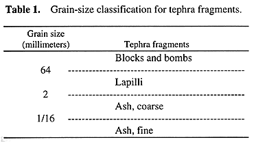 |
| A basic grain-size classification scheme for tephra, pyroclastic fragments that were thrown out of volcanoes, courtesy USGS. |
All the other references I found state that the cone is about 390,000 years old without providing credit to an original source.“...the basalt has been K/Ar-dated at ~400,000 years (J. Witter, pers. comm., 2008), but this age is at odds with the cone’s barely-disturbed morphology. Accordingly, Witter has submitted a sample of basalt flow rock, clearly sourced from the cinder-cone vent (Figure 3B) for more reliable 40Ar/39Ar age-dating.”
After parking and getting out of the truck, I walked around for a little while, trying to find some good examples of volcanic bombs. Rather than collecting any hand samples, I took a few photos.
 |
| Vesicular basalt. |
 |
| Volcanic bomb with a ropy or fluted texture. |
 |
| This could be a bit of flow or cooling texture in a basalt lapilli, but I'm not sure. |
 |
| A large block of basalt with ropy and vesicular texture. |
 |
| And here's a closer shot. |
 |
| Here's a bomb with fluted texture, approaching spindly. |
 |
| A spiny bush and a prickly pear cactus growing on a desert pavement of basalt lapilli, small blocks, and bombs. |
 |
| We can see the Weepah Hills and bluish Lone Mountain off to the northeast, beyond the dark, lower slopes of The Crater. |
Selected References:
Albers, J.P., and Stewart, J.H, 1972, Geology and mineral deposits of Esmeralda County, Nevada [available for sale only]: NBMG Bulletin 78, 80 p.
Hulen, J.B., 2008, Geology and Conceptual Modeling of theSilver Peak Geothermal Prospect,Esmeralda County, Nevada: unpublished report for Sierra Geothermal Power Corporation, 23p.
Price, J.G., and Price, E.M., no date, Cinder cone in Clayton Valley, Esmeralda County, Nevada: NBMG, Nevada EarthCaches webpage (with .kmz downloads available), accessed 18Feb2016.
Spurr, J.E., 1906, Ore Deposits of the Silver Peak Quadrangle, Nevada: U.S. Geological Survey Professional Paper 55, 174 p.
Related Posts:
Thesis: Finding an Area
Finding a Thesis: Battle Mountain to Austin to Gabbs
Finding a Thesis: Pole Line Road
Finding a Thesis: Pole Line to Belmont
Finding a Thesis: Klondyke District
Finding a Thesis: A Joshua Tree Aside
Finding a Thesis: Into the Palmetto Mountains
Finding a Thesis: Farther into the Palmetto Mountains
Finding a Thesis: A Bit O' Geology in the Palmetto Mountains
Finding a Thesis: Future Stories from the Palmetto Mountains
Lida Summit Roadcut
Finding a Thesis: Next Stop, Silver Peak!
Finding a Thesis: Coming into Clayton Valley
Finding a Thesis: On the Southern Route to Mineral Ridge
Finding a Thesis: The Northern Route onto Mineral Ridge and a Little Geology
Finding a Thesis: Up to the Millsite and Back
Finding a Thesis: Views and Geography and ... Oh, What's That?
Location:
The Crater, Nevada, USA
Tuesday, February 16, 2016
Finding a Thesis: Views and Geography and ... Oh, What's That?

 |
| The Crater, beyond the metal posts of the old gate. |
The Weepah Hills is a more-or-less circular batch of disorganized lowlands, hills, and mountains, with the apparently chaotic to jumbled geologic formations of the area having been horizontally sliced by low-angle faults of probable detachment origin. Tertiary Esmeralda Formation sediments and Quaternary older alluvium cover much of the western part of the hills; a granitic body, the Weepah pluton, probably the same age as the 70 Ma Lone Mountain pluton to the northeast, crops out in a broad area in the northern hills; and a couple small patches of Precambrian Wyman Formation and Reed Dolomite poke through near the central part of the area. The rest of the area is mostly underlain by Cambrian to Ordovician sedimentary formations. Sunshine Mining Company took out a bit of gold at Weepah in the mid 80s; a few other companies have taken a look since then, but so far no additional mining has resulted.
These topo maps show the topography and main features of the area.
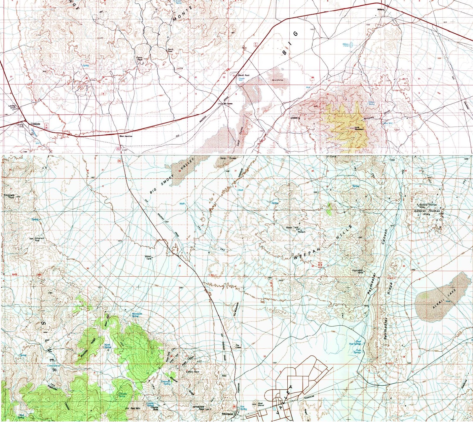 |
| The spliced Goldfield and Tonopah 30 x 60 maps (courtesy USGS). |
 |
| The same map with a few labels. |
 |
| Here, I've thrown on a few lineaments, including one going up Paymaster Canyon, which gives the eastern side of the Weepah Hills a linear look. |
 |
| I'm not sure what this old sign said, but it's totally bitten the dust. And it looks like it got run over by a tracked vehicle of some sort. |
 |
| An old, though not very old, blasting sign. |
At The Monocline, a thin, dark basalt layer caps soft, white sedimentary rocks, which, according to the Esmeralda County report, are part of the Tertiary Esmeralda Formation. These units have been tilted, maybe as much as 10 degrees.
 |
| A closer view of The Monocline and its closer, sister hill, from Google Earth. |
 |
| The Monocline, part of a mine dump, The Crater, and Clayton Valley playa. |
 |
| The Crater. |
Selected References:
List of minerals at Weepah: Mindat.
Weepah Mine: Western Mining History (info last updated in the 80s or 90s).
Weepah Deep: unpub 1989 info from Sunshine Mining Co and FMC Gold.
Weepah Mine in the County of Esmeralda Nevada: unpub 2008 report—much of this info is good, but ignore the Regional and Local Geology sections.
Weepah Reconnaissance/Submittal Summary: unpub 2014 recon report.
Maldonado, Florian, 1984, Bedrock geologic map of the Lone Mountain pluton area, Esmeralda County, Nevada: U.S. Geological Survey Miscellaneous Investigations Series Map I-1533.
Related Posts:
Thesis: Finding an Area
Finding a Thesis: Battle Mountain to Austin to Gabbs
Finding a Thesis: Pole Line Road
Finding a Thesis: Pole Line to Belmont
Finding a Thesis: Klondyke District
Finding a Thesis: A Joshua Tree Aside
Finding a Thesis: Into the Palmetto Mountains
Finding a Thesis: Farther into the Palmetto Mountains
Finding a Thesis: A Bit O' Geology in the Palmetto Mountains
Finding a Thesis: Future Stories from the Palmetto Mountains
Lida Summit Roadcut
Finding a Thesis: Next Stop, Silver Peak!
Finding a Thesis: Coming into Clayton Valley
Finding a Thesis: On the Southern Route to Mineral Ridge
Finding a Thesis: The Northern Route onto Mineral Ridge and a Little Geology
Finding a Thesis: Up to the Millsite and Back
Location:
Old gate on Mineral Ridge, NV, USA
Tuesday, January 26, 2016
Hiking Down Glass Mountain

I had vowed to myself, and to MOH, to keep my eye out for some reddish, oxidized glass on the way down...
 |
| ...and indeed, I found some. |
 |
| I've zoomed in a little here. The black glass looks a little bluish because it's reflecting the sky (what little of it was showing through the clouds). |
 |
| This rock from in an earlier post shows thin, oxidized bands and streaks, and I'll have to let it stand for a closeup example, although the reddish orange color is not as intense as in some smaller pieces or in the outcrops above the road. |
 |
| Looking out over the northern dacite flow, and beyond to Timber Mountain. |
The northern dacite flow is the darker flow area in the upper part of this Google Earth image. The rhyolite flow is the long, almost cylindrical-shaped area emanating from Glass Mountain itself, the small, grayish, round area west and a little south of center.
 |
| Read more about the geology in this post. |
 |
| An old tree grew around a large obsidian boulder (and is therefore younger than the flow). Trees are fairly sparse. |
 |
| A geo-type walks down the trail. |
 |
| Pine trees grow on the angle-of-repose slope, their trunks bent from downhill creep of the colluvium. |
 |
| I've zoomed in here to take a closer look at a mass of oxidized, reddish brown obsidian near the base of a large, conchoidally fractured obsidian outcrop. |
 |
| Finally! Down the trail just in time for lunch. |
 |
| An unreadable metal sign in front of the dacite flow. Maybe it said "Keep Out," once upon a time. |
Related Posts:
A Hike Up Glass Mountain
Views from Glass Mountain (and some geology)
Which of These Rocks, Mostly from Glass Mountain, CA, Will Float
The Conclusion of Our Float Test
Hiking Down Glass Mountain (this post)
Links: Pumice and Pumicite
Friday, January 22, 2016
Aerial Views of Two Northwest Volcanoes

I waited until Rainier moved fully into view for the next shot:
 |
| Photo looking almost due east. |
In the view above, we're looking at the head of the South Fork of the Mowich River just left of center in the foreground. The small ice field above and left of the river head is Edmunds Glacier. The shadowed icy mass to the left of Edmunds is the North Mowich Glacier, which is above the North Fork of the Mowich River (mostly out of view).
A radial dike runs from between the two closer and less elevated peaks to the lower right, into what is the headwaters of the North Puyallup River. The landform formed by the radial dike is known as Puyallup Cleaver.
 |
| Photo looking a little east of northeast. |
I was on the wrong side of the plane to see Mt. St. Helens, but had this great view of Mt. Adams as the sun went down and the light got pink. Notice the reddish irridescent lenticular cloud off to the side.
 |
| Mt. Adams looking almost due east. |
Location:
Mt. Rainier, WA, USA
Thursday, January 14, 2016
2015 Top Ten Posts at LFD...
...and—as for 2014, 2013, and 2012—a few more. My rules, as modified from last year:
January:

February:

March:
April:

May:

June:

July: No posts in July!
August:
September:


October:


November:

December:

And so, here are the top 10 posts, plus 2 extra, along with a few pretty pictures:Because of the vagaries of stat reporting (in this case, by Google Analytics), I'm listing both the top ten posts for the year (in large font, with respective Top Ten number), and the top post for month's without a top-ten posting (non-Ten-rated posts are in a smaller font).
January:

February:

March:
April:

May:

June:

July: No posts in July!
August:
September:


October:

November:
December:

Subscribe to:
Posts (Atom)