Showing posts with label alcan. Show all posts

Saturday, October 29, 2011

Alcan Geology Series

My two posts on Folded Mountain are perpetually popular, at least from searches, so I've put together this mini-series of roadside geology along the Alcan, or Alaska Highway, or Highway 97 (British Columbia). If I knew more about the geology along that road, I might post more of my photos from my several trips.

Alcan Geology and Related Posts:
Where on (Google) Earth #158
Folded Mountain, B. C.
Folded Mountain, B. C. - A Reprise
Muncho Lake, B. C.
More Muncho
Some Alcan Mileage Links

I also have two more posts about Canada, with some introductory or basic geology:
     Where in the West: October 2010
     Where in the West: Rose Spit, B.C., Canada

Thursday, December 23, 2010

Some Alcan Mileage Links

While we're experiencing being semi-snowed in, I'm going to post a few Alcan links, in case any of you have been thinking about driving that highway this winter. (I've been thinking of it, but decided that I don't have enough time right now.)

Alaska Highway - at Wikipedia

Alaska Highway or Alcan? - some history

Alaska Highway 97 - towns and more info at BritishColumbia.com

Alaska Highway Road Log - road log by miles and kilos

Bell's Travel Guides: Alaska Highway - another road log

MilebyMile.com - photos along the Alaska Highway

Saturday, January 16, 2010

More Muncho

I'm planning to clear out a few draft posts from last year, and also to hopefully finish up some mini-series. I'm starting by taking a leap back to the dark ages of 2009 - February, that is. I had nearly completed a series I started about the northern Canadian Rockies, centered around Folded Mountain and Muncho Lake. I'm going back there again, this time to a location on the Alcan Highway about 7 miles or 11 km south of the south end of Muncho Lake: the pullout at Mile 426/km 686, Alcan mileage (current mileage). I think this is the "Sawteeth" pullout, which has a sign that may or may not explain the geology of the Sentinel Mountains. I can't actually follow the explanation, so I won't show you the sign! (I mean, it doesn't make any sense to me.)

This oblique southeasterly view of the Sentinel Mountains from Google Earth shows the general area from a little higher than roadside level; that's the Alcan, AKA Highway 97. The topography of the same area, looking straight down and with the north arrow cocked to the right, can be seen here in The Atlas of Canada.
The picture I took looks like this; it corresponds with the two central peaks from the Google Earth image, with just a little of the pyramidal-shaped range-front hill on the far left.
Drawing on a composite set of photos, I came up with this pen-and-ink interpretation, which shows the general flat-lying nature of the sedimentary horizons away from the range front and to the east. The beds are then tilted into a dip slope right along the range front, forming a set of triangular-shaped facets, which I described more completely earlier. If you look carefully at the photo and the sketch, you'll see that they match up imperfectly - the sketch makes the farther hill appear a little larger than life. It is a cartoon.

The Folded Mountain and Muncho Lake Series:

You'll find references, in-post links, more photos and images, and more about the Alcan and general geology in the previous posts.

Wednesday, February 18, 2009

Muncho Lake, B. C.

lake1

Muncho Lake, a scanned postcard version.

Continue to the west and then north on the Alcan, beyond Folded Mountain. After stopping to view Stone Sheep (or Stone's sheep - Ovis dalli stonei) in the highway (a common site), you will come to Muncho Lake, about 36 km from the Folded Mountain turnout. Just so you remember where you started from and have some idea of where you're going, in this topo map, Folded Mountain is in the lower right, just to the left of the Nonda Creek label; Muncho Lake is prominent toward the upper left.

Muncho Lake is pictured above in a scanned version of a postcard I bought somewhere, somewhen on one of my Alaska Highway travels. Again, as in one image in my last post, the postcard seems to have been taken from a hovercraft or airplane; it looks northward.

The light-colored mountainous area, seen to the right (east) of Muncho Lake, is the Sentinel Range, part of the northern Canadian Rocky Mountains. The range continues a little to the north, just out of the postcard picture. I think it ends to the south at the Toad River and the Alaska Highway, although the geology and structure making up the Sentinel Range continues southward beyond the ToadRiver-road line of demarcation.
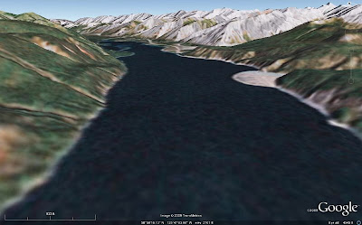
lake2 Above, I've more or less duplicated the postcard view of Muncho Lake with an image from Google Earth. We will be zooming in on a portion of the range front below, in a Google Earth view looking north from a height of about 472 ft (144 m) above ground level (I forgot to switch to meters in my new Google Earth version 5 right away!). The closeup focuses in on the third of several triangular-shaped mountain faces above, and it shows most of the second face in the foreground and part of the fourth face (and beyond) in the background.
range-img These triangular-shaped range faces are dip slopes, with the carbonate beds dipping almost entirely parallel to the faces. These shapes could be called triangular facets, though they are not strictly fault-caused - nor are they the result of truncated spurs - and they are reminiscent of the flatirons along the Rocky Mountain range front in Boulder, CO, though bedding there dips eastward, and bedding above dips westward. Locally, these shapes in the Sentinel Range are called sawteeth. [If there is a better geomorphic or descriptive term for these triangular shapes than what I've used here, I wouldn't mind some input!]
range-pic This photo, taken in 1996 from the north end of Muncho Lake, duplicates the Google Earth image above (or the other way around), and shows the beds dipping parallel to the range front slope. The drawing below highlights the bedding.
range-sketch So, from Folded Mountain, here, we've gone to this northern end of Muncho Lake, here, and are centered in on the triangular part of the range front at the very north end of the lake, here.

Tuesday, February 17, 2009

Folded Mountain, B. C. - A Reprise

Back to our semi-regularly scheduled program, as erratic in content as it sometimes is...
image1 Just pretend that you are still on the Alcan, in that in-between place between Toad River and Muncho Lake in northern British Columbia, Canada. You've just driven to the famed Folded Mountain turnout, pulled out to read the sign, and are now looking at Folded Mountain. If you look to the north, you'll see views like the two I've so cleverly created from Google Earth: the first one, above, looking north from about 450 m above the ground; the second one, below, looking north from just as close to ground level as I could get Google Earth to go, 60 m above the ground.
image2 I don't usually have a hovercraft with me while driving the Alcan, so I usually look at things from ground level, having never spent enough time on the highway to do any hiking around. A hovercraft could, however, be a useful thing to have on this supposedly paved highway: it always seems like major - I mean major - road construction is in progress somewhere along the way. Too bad I don't have photos of some of the boulder fields I've driven through on the supposedly paved highway.
folds Suprisingly, a 1993 photo taken from or near the Folded Mountain turnout looks very similar to the second Google Earth image, but in the photo you can actually see some of the folds. And someone has drawn on the photo, approximately outlining some of the folds. Please ignore the pen lines on the upper part of the mountain - that part is too obscure for drawing to be of any use whatsoever - without having the actual mountain handy (which it's not).

Soon, we'll move just a little farther along the road to Muncho Lake, but first I must take a break. Farther up the road, my drawings will become a little more sophisticated. (But not because of the break!)

Tuesday, February 10, 2009

Folded Mountain, B. C.

My familiarity with Folded Mountain, most recently known as WoGE #158, is from several trips up and down the Alcan, or Alaska Highway, or Highway 97 (British Columbia): four trips through the Fort Nelson to Liard Hot Springs area, two each way.
toad And here, above, is the greater Fort Nelson to Liard Hot Springs region of British Columbia, Canada. Liard River is a tiny community at Mile 496 (HM) of the Alaska Highway; Liard Hot Springs, aka Liard River Hot Springs, is at Mile 497 (HM). I note the location of the hot springs on the image above - rather than that of Liard River - well, because the springs are a great place for a soak if you happen to be passing through.

Muncho Lake
is a lake inside Muncho Lake Provincial Park at Mile 456 (HM) - the lake actually takes up quite a bit of north-south mileage along the highway, but mileage is traditionally taken from a particular historic refueling stop. Toad River is a town, at Mile 422 (HM) on the Alaska Highway; The Poplars at Mile 426 (HM) is a nice place to stay, with large logs making up rustic cabins (late 1990's info). HM = historical milepost; actual miles and kilometers have changed with road changes.
munchoZooming in a bit above, we can see our particular area of interest better: Muncho Lake, the NNW-trending Sentinel Range of the northern Rocky Mountains, and Folded Mountain (link to topography provided by Ron Schott).
mtn1 Here's the Google Earth shot I considered using for WoGE #158. It's an image looking west, from one point on the highway where one can stop and take a photo.
mtn2 And this is what that image would look like at near ground level, just about what you would see while driving west on the Alcan.
pic1 A photo! Now we can begin to see why it is, at least locally, called Folded Mountain.
pic2 Folds!
pic3 Close-up of the same folds!
fold And closer still, from a postcard I probably bought back in 1998 at The Poplars.
signThis is the sign at the Folded Mountain turnout, right at the eastern base of the mountain, at mile 409/km 658 (current mile/km):
Originally, all the rock of the British Columbia Canadian Rockies lay flat on the shallow sea bed of the western continental shelf where it had accumulated grain by grain over a billion years. About 175 million years ago the continent of North America began to move westward, overriding the Pacific shore and colliding with the offshore chain of islands. The continental shelf was caught in the squeeze. The flat layers slowly buckled into folds like those you see here. As time passed, folded mountain ranges sprang up across British Columbia. By 120 million years ago, the Rockies were showing above the sea. They grew for another 75 million years, rising faster than erosion could tear them down - likely reaching Himalayan heights. Active mountain building ended in the Canadian Rockies some 45 million years ago. The peaks have since been eroded to a small fraction of their original size.
Additional and more detailed geological information can be found in the comments of my WoGE #158 post.

Some Geological References:

Friday, February 6, 2009

Where on (Google) Earth #158

Click Image to Enlarge

I just won my second Where on (Google) Earth, yesterday, from Dave Schumaker at Geology News - his first time to win!! - after he posted Mt. Ruapehu, New Zealand for WoGE#157. A second win, a second volcano!!

That means I get to post the #158 edition of this fine game. I think I got lucky: 1) I was online when #157 was posted, 2) for some reason I thought the place looked familiar, although I'm really not sure why, and 3) so I was convinced I could find it! I recognized it as a volcano, and so first looked in all the usual places (the Cascades, for example), and then I wondered... Dave said it was one of his favorite areas; so I looked, and sure enough, he had posted about the volcano back in 2007: I found it first on his website! I think it looked familiar because of the beige silty ash color of the mountain, or maybe it was the crater lake...

To win this game, be the first to find and the first to post the correct latitude and longitude of the above unknown area in the comments, and also describe as much of the geology of the area as you can. I'd be greatly pleased if you could name the closest mountain, which is in the center right above the tiny Image (c) 2009 TerraMetrics lettering. If you win, you get to host the next WoGE on your blog. (Non-blog winners have a chance of hosting right here!)

I am invoking the Schott Rule this time, which means that former winners have to wait exactly one hour per win before posting their answers. Former winners and former locations can be found here. Post time will be 5:00 pm Pacific Standard Time, GMT-8.