
Showing posts with label mountain. Show all posts
Showing posts with label mountain. Show all posts
Sunday, June 6, 2021
Washoe Lake, Slide, Mt. Rose, and Lake Tahoe
Location:
Mt Rose, Nevada, USA


Tuesday, May 30, 2017
High Water Across the West: The Humboldt River at Winnemucca and Humboldt Station

The flooding in Winnemucca was really quite extensive when I drove through on April 11th (no photos) and then again on the 19th: several backyards and a few basements or first floors of houses near the defunct "Barrick Arms Apartments" were under water. The water had receded incompletely when I saw it last (May 28th).
These first pics show the Humboldt River's floodplain looking more like a marshy lake than it's usual dry self. Water level was slightly lower on April 19th than when I first saw it on the 11th.


On that same day (the 19th), I pulled off I-80 at Humboldt House (exit 138, marked "Humboldt") and drove old Highway 40 back toward Imlay.


Thursday, February 4, 2016
My "New" Toy
 |
| Yes, that's an 18-200 mm zoom. |
I struggle some with accurate color balance when posting on the web. Cameras in general don't shoot accurate color by themselves, hence enhancement or editing. Hence white and gray cards, e.g., this one. Maybe I'll get one. (Any white balance setting on a digital camera is a type of programming—except, perhaps, the PRE or custom setting. Any choice you make is, imo, a type of editing.)
So far with this camera, I've been using auto white balance (AWB), although I know the camera will shoot warm under indoor lighting, and so it will usually require a change to tungsten or something else when indoors. With AWB, the color on the LCD screen has, so far, fairly well matched the color of what I see when shooting, or maybe it's too reddish or bluish on occasion. Of course, when using a DSLR one can't actually see anything on the LCD screen until after taking a shot, because the process of DSLR is different, and one looks into the viewfinder to see exactly what the camera is seeing.
These first pictures below were taken from 395 north of Reno on a fairly gray day. I've enhanced the photos such that they look to me the way they looked on the LCD screen, although they are all probably off, in color, by a hair. I think the next picture could be slightly yellower, but my opinion of it seems to vary depending on what I looked at last.
 |
| Sunlight hitting the west part of Seven Lakes Mountain, the part that's in California. |
 |
| Some rocky crags on Petersen Mountain (MyTopo location). |
 |
| Petersen Mountain from a little farther south. |
 |
| And here's a shot of one of the northern peaks on Peavine, looking southeast from about the stateline near Bordertown. |
I have, in the meantime, taken a lot of nice photos, particularly some zoomed-in photos of birds. But I'm still figuring out the many settings and possibilities, and am finding the color a little odd in shadowy settings.
Tuesday, September 8, 2015
Way Too Much Smoke: Volcanoes (and Rivers and Ridges) in the Pacific Northwest
 |
| Mt. Jefferson |
Whereas I first estimated I was somewhere over central Oregon south of Sisters or Bend, it soon became apparent that I was probably a little farther north than I thought — and it turns out I was between Sisters and Portland looking at Mt. Jefferson (first photo).
 |
| Mt. Hood |
 |
| Mt. St. Helens |
 |
| Mt. St. Helens |
 |
| Mt. St. Helens and Mt. Adams |
 |
| North Fork Toutle River |
 |
| Smoke amid the low hills between Mt. St. Helens and Mt. Ranier |
 |
| One last look at Mt. St. Helens |
 |
| Mt. Ranier |
 |
| A last view of Mt. Ranier, seen as the airplane descended toward SeaTac. |
 |
| Smoky wisps interfinger with some low hills north of the airport after take off several hours later. |
A Bit More about Mt. St. Helens:
Where in the West: Mt. St. Helens — LFD
Mt. St. Helens Field Trip — LFD
It's the 35th Anniversary of the Big Ba-Boom: Mount St. Helens and the May 18th Eruption — Rosetta Stones
Why Have Volcanoes in the Cascades Been So Quiet Lately? — Eruptions
Location:
Cascade Range, USA
Monday, June 9, 2014
Views from Majuba Hill
Here are a few photoviews from Majuba Hill, while I get it together to take some rock photos:
Mindat has a photo showing what the above structure looked like in 1970, although the angle isn't great. At that time, the entrance to the adit was wooden (current view of the adit entrance at my previous post). You can see a good side view of the structure here (photo also from Mindat), as it looked in 1980. According to one source, there may have been a 1000-foot-long tramway leading from this site to an ore bin. I have a couple ideas where this could have run; maybe I'll get a chance to post the ideas later.
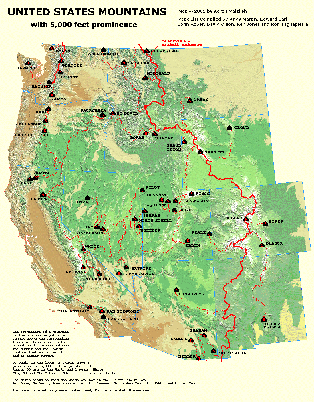
Star Peak, at 9836 ft (2998 m), is the tallest peak in this view. It's the pointy one on the left. Star Peak is one of the 57 peaks in the lower 48 with 5000 feet or more of prominence (prominence explained here with a map of peaks in the west), and it ranks #6 in prominence in Nevada. The round "hill" in the center is 8940 ft, and the seemingly lower hill a little right of center, which is a bit farther in the distance, is an unnamed peak at 9031 ft.
 |
| Wooden structure (trestle and ore bin?) on the mine dump of the Middle adit. |
 |
| View looking off toward the Humboldt Range. |
 |
| Looking across an upper part of Rye Patch Reservoir at the Humboldt Range. |
Friday, January 10, 2014
Where in the West: Dean and Burke Channels; Thunder Mountain and Tzeetsaytsul Peak, B.C.
 |
| Dean Channel on the left, Burke Channel on the right. |
I didn't know the location of this challenge when I posted it, but having seen it from the air, I knew it was between Anchorage and Seattle, that it was south of a more-or-less north-south-trending strait, and that it was much closer to Seattle than Anchorage and probably south of SE Alaska. This general knowledge gave me an advantage over anyone else trying to discover the location. I homed in on the location and found most of the names of the fjords and mountains on Google Earth (in labeled photos), but wasn't sure if the names were correct, so checked them on Wikipedia and GeoBC.
 |
| Google Earth image almost identical to my first photo. Dean Channel is on the left; Burke Channel is on the right. |
 |
| A photo zoomed in on Burke Channel. |
 |
| Google Earth image with Burke Channel centered, similar to the previous photo. |
 |
| Zoomed in photo with the mountain in question in the distance. |
 |
| Google Earth view, with the North Bentinck Arm of Burke Channel on the left and the South Bentinck Arm heading southward to the right. |
 |
| Google Earth image: Thunder Mountain is the highest peak in the center; Tzeetsaytsul Peak is the next highest peak to the left (north). |
 |
| Google Earth view of Tzeetsaytsul Glacier on the east side of Tzeetsaytsul Peak and Thunder Mountain; north is to the right. |
A few Geological References:
Gehrels, George E., and Nevine D. Boghossian, 2000, Reconnaissance geology and U-Pb geochronology of the west flank of the Coast Mountains between Bella Coola and Prince Rupert, coastal British Columbia: Geological Soc America, Special Papers, v. 343, p. 61-76. Abstract at Refdoc.fr.
Mahoney, J. B., et al, 2002, Structural geology of eastern Bella Coola map area, southwest British Columbia: Geological Survey of Canada, Current Research, 2002-A10, 9 p.
Smith, D. J., and Desloges, J. R., 2000, Little Ice Age history of Tzeetsaytsul Glacier, Tweedsmuir Provincial Park, British Columbia: Géographie physique et Quaternaire, v. 54, no. 2, p. 135-141.
Stowell, Harold Hilton, and William C. MacClelland, eds., 2000, Tectonics of the Coast Mountains, Southeastern Alaska and British Columbia: Geological Society of America, Special Papers v. 343, 389 p.
A few Geographical Links:
Dean Channel location - at GeoBC
Fitz Hugh Sound - Wikipedia
Fitz Hugh sound location - at GeoBC
Labouchere Channel location - at GeoBC
North Bentinck Arm location - at GeoBC
South Bentinck Arm location - at GeoBC
Thunder Mountain location - at GeoBC
Tzeetsaytsul Peak location - at GeoBC
Monday, January 6, 2014
Where in the West: January 2014
I won't mention exactly how long it's been since I posted a Where in the West (or the one and only Where in the North), because I don't have the means to look it up right now (I'm writing this without an internet connection). Suffice it to say that it's been quite a while.
The photos below are of snowy, mountainous country with fjords and -- for additional location-enhancing info -- with a particularly high mountain in the background. As I write this, I know only the general location: somewhere between Anchorage and Seattle.
Where in the West (WITW) always features a location in the western part of the northern hemisphere. Be the first to identify the location -- hopefully the fjords and a mountain or two have names -- and if you can find out a bit about the geology (hint: glacial?), all the better.
This should be easy to find, and sorry, no prizes.
The photos below are of snowy, mountainous country with fjords and -- for additional location-enhancing info -- with a particularly high mountain in the background. As I write this, I know only the general location: somewhere between Anchorage and Seattle.
Where in the West (WITW) always features a location in the western part of the northern hemisphere. Be the first to identify the location -- hopefully the fjords and a mountain or two have names -- and if you can find out a bit about the geology (hint: glacial?), all the better.
 |
| Two fjords. |
 |
| Zooming in on the fjord on the right in the first photo, from a slightly different angle, with a fairly tall mountain near its head. |
 |
| Zooming in on the high mountain, slightly off-center to the left, with the fjord now nearly out of the picture on the left. |
Location:
Western North America
Monday, December 30, 2013
Mt . Jefferson from the Air
I thought I'd try posting from my new mobile device, using a photo I snapped the day before Xmas while en route between Reno and Seattle. I see I'm going to have to go online with my computer to check the draft and maybe make changes, because I don't like the Blogger app's method of determining my location -- I can't seem to enter the actual location of the phone, I'm only able to choose from nearby places. Also, I can't tell where the photo will end up in the post.
So, it turns out that the photo ends up being too large for the blog space, and it was crammed up against the text, which I normally might prefer having below the photo. Possibly I can use the online webpage to create a draft or post, rather than the Blogger app.
 |
| Mt. Jefferson from the air. |
Location:
Mount Jefferson, Oregon, USA
Sunday, November 17, 2013
Update from the Lake and AK, and a Tribute


Alaska Al, besides these things, has had some photos published in this blog, and has been the source for other photos of mine, particularly photos of certain rocks and minerals. His hand lens is shown here; his field Brunton here.
 |
| Mt. Foraker (right) and Denali (left) seen from the hills above Anchorage in early November. Alaska Al had much better photos of Denali than these! The Mountain (as it's called up there) will always remind me of him. |
 |
| The almost record late first snow fell a few days after I took the photo of Denali. |
Location:
Alaska, USA
Tuesday, May 14, 2013
Slickenside Ridge #3

Coming up Slickenside Ridge past the last little slickenside, we came upon this whopper.
It's hard to tell from this photo, but fractured, brecciated, and slickensided dike rock on the far side of the fault plane is juxtaposed against more dike rock, which is what I'm standing on to take the photo. The fault is dipping more or less to the east, and the slickenlines are almost straight downdip (slightly oblique).
 |
| A closter view of the lower part of the slickenside. |
 |
| An even closer view of the lower part of the slickensided surface. |
We also noticed a nearby cross-cutting fault of minor displacement running about east-west, offsetting this fault and the faulted dike-dike contact by a few feet. Apparent offset across this cross fault was south side to the east (the fault was poorly exposed and dip direction wasn't obvious).
 |
| View of "Dike Hill" across Water Canyon. |
 |
| We viewed the hill again a little higher up, from this little shadow created by an outcrop of quartzite. |

Our hike wasn't over, though...
Location:
Water Canyon south ridge, NV, USA
Subscribe to:
Posts (Atom)