Showing posts sorted by date for query great basin national park. Sort by relevance Show all posts

Monday, November 28, 2016

The Left-Lateral Strike-Slip Garlock Fault Near Highway 395

While out on the last road trip, I started taking pictures from places where roads crossed the Great Basin Divide. Unfortunately, I soon gave that up because freeways, which I traveled not exclusively but considerably, are lousy places from which to take pictures. But thinking about divides also made me think about the Garlock Fault, and how I'd be crossing it on 395 heading south into the Mojave. Here I've pulled over as I'm about to cross the fault.
I've drawn the Garlock fault with a thick blue line, and a secondary strand (air-photo linear) with a thinner blue line.
Besides the two fault strands, you can see the towns of Randsburg and Johannesburg, which were founded in 1896. The Yellow Aster open-pit gold mine was operated by Glamis Gold from about 1987 to 1997.

The haze was thick and the day overcast, and it looked like the photos I was taking would be fairly lousy, but MS Photos was surprisingly able to revive the dark, lackluster originals (I usually don't rely on the Photos app, but in this case it worked better than my other free programs).

After crossing the fault on 395, I took the road toward Goler Heights and Garlock. (Goler Gulch in the El Paso Mountains at Goler Heights is unrelated to Goler Wash in the Panamint Range at the edge of Death Valley National Park.)
Looking west along the southern range front of the El Paso Mountains toward Goler Heights.
The Garlock Fault is mostly behind low hills in this shot, and it runs to the right of us about three quarters of a mile to the north.
I've drawn in two (or three) apparent strands (or air-photo linears―my interpretation may not be precise in all cases) in dashed blue lines; where thin, the fault is behind hills or out of view.
We're now back near the junction of the Goler Road with Highway 395, looking to the northeast.
I took this photo thinking that we might be seeing part of the Garlock Fault, when in fact what we're seeing is a couple of fault strands parallel to the Garlock (air-photo linears).
The Garlock Fault proper is out of view beyond the low hills.
A little more than a mile to the NNE from the place I took that last photo (above), there's a great example of a shutter ridge and offset drainages.
Google Earth image with a blue line I added using the "Path" function.
The same image with more scribbles.
This marked up Google Earth image shows a small portion of the left-lateral Garlock Fault (long blue line). The fault line is basically the same as shown here (Roder, 2012). If you blur yours eyes a little (and even if you don't), you'll probably see several lines or linears that are running parallel to the main fault trace. I drew a few of these in with thinner dark blue lines. I can easily spot a few more.

The fault has offset two drainages in a left-lateral sense; that is, the south side of the fault, moving to the northeast (right) has brought in a ridge that has blocked the dry wash in the center of the image, forcing it to flow to the northeast to get around the ridge. That ridge is labeled "shutter ridge," which is the term for a ridge that blocks a drainage in this fashion along any strike-slip fault, whether it's right lateral, like the San Andreas, or left lateral like the Garlock. A second drainage way off in the upper right corner of the image has been blocked and offset in the same fashion. That drainage appears to have two shutter ridges, one that is north of the main trace of the fault, and another that looks like it's south of the main trace (at least the way the main trace has been drawn; we can see by drawing in just a few air-photo linears that there may be a few complications, and faults often meander around a bit).

I got back onto Highway 395 and continued south toward my destination, figuring that I could get a photo looking back toward the Garlock from somewhere up near the turn-off to Randsburg. I finally found a pullout on the east side of the highway; it offered me a four-wheeling opportunity to drive a very narrow, rocky road to the top of a small hill. The photos I took from there looked really lackluster, so I didn't spend a lot of time trying to get a really good panorama. Consequently, the two photos I've stitched together below do meet up on the horizon, but they are way off in the foreground, primarily because I ended up moving to keep the dirt road I was on out of the picture. We can, nevertheless see where the Garlock and a couple parallel strands or linears are located.
Stitched photo. The center of the photo is looking just west of north.
The same photo with a few labels.
And that's basically it for the Garlock Fault, but there's a location near Goler Heights that might be a good spot to look around the fault, and there are probably some good locations near Garlock.
Looking northeast from Goler Heights along the Garlock Fault.
UPDATE: Be sure to view Ron Schott's GigaPan of this portion of the Garlock Fault.

Wednesday, January 2, 2013

Great Basin Dotmap

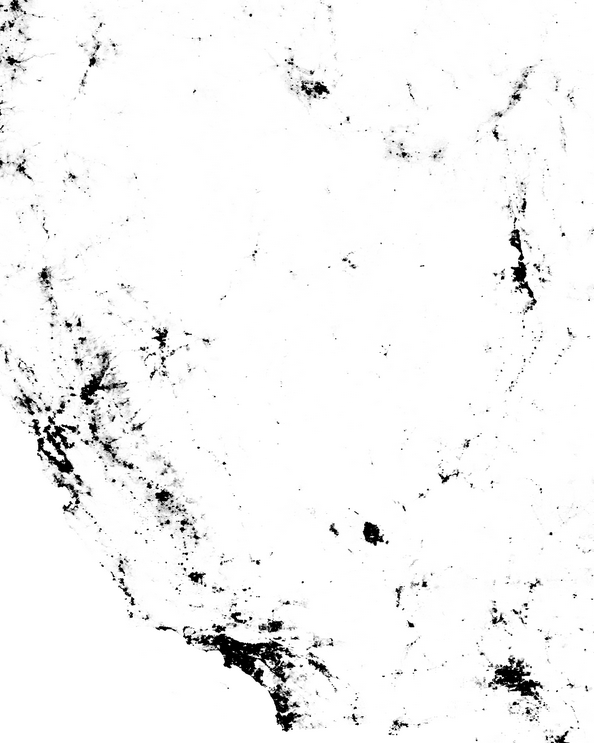
I thought I'd have a little more fun with the Census Dotmap I posted about a couple days ago, by conjuring up a shot of the Great Basin:

Screenshot from Census dotmap by @ewedistrict and @kieran.
The dotmap highlights the lack of people living inside the Great Basin. Instead, the bulk of the population is outside, or is located around the edges (Salt Lake City, Las Vegas, Reno). The northern boundary of the Great Basin is vague in the dotmap view, but the Snake River Plain to the north of the Great Basin's northern edge is easily identified. The northwest and southwest boundaries, near Goose Lake and Death Valley respectively, are also somewhat vague on the dotmap.

Two more views of the Great Basin:
Greatbasinmap by Kmusser [CC-BY-SA-3.0], via Wikimedia Commons.
Great Basin in magenta, from National Park Service.

Friday, September 9, 2011

Friday Field Photos: Folded, with Lineation

This is a small glacial boulder of folded meta-argillite, possibly from the Precambrian McCoy Creek Group, which I found along the trail between Stella and Teresa Lakes, beneath Wheeler Peak in Great Basin National Park, close to last week's boulder. The greenish, coarser-grained layers accentuate and define the folding, which otherwise would be more difficult to see in the reddish or purplish gray layers.
Zooming in on the small boulder, I'm poining at some crude lineations, which my finger roughly parallels. The green bed at the top of the boulder is also lineated.
The lineation direction theoretically defines the direction of motion present during the tectonic event that created the lineations and possibly the folding. If we had some context, if this rock was part of an outcrop, we could look perpendicular to the lineation direction, instead of parallel to it the way we are now. While looking perpendicular to the lineation direction, the nature of the folding or of other micro- to meso-scale structures might tell us relative motion of beds during the lineation-forming event, for example top-to-the-east or top-to-the-west. Because this rock was part of a glacial moraine, it could tell us very little about the tectonic events it had been exposed to during the course of the last 540 million years or so. (GSA Geologic Time Scale.)

Friday, September 2, 2011

Friday Field Photo: Cross Bedding in Quartzite

This small quartzite boulder, found in morainal deposits between Stella Lake and Teresa Lake below Wheeler Peak in Great Basin National Park, shows cross-bedding defined by dark purplish to reddish laminations. Up appears to be to the left. Without a stratigraphic context it's hard to say whether this quartzite is part of the late Precambrian McCoy Creek Group (pCMc) or the possibly late Precambrian to mostly early Cambrian Prospect Mountain Quartzite (Cpm), but most slopes uphill from this spot are in the Prospect Mountain Quartzite. Depositional environment was likely nearshore to offshore marine.

Saturday, August 27, 2011

Alpenglow and Tentglow

On the way over to Great Basin National Park last week, I grabbed this quick photo of the alpenglow hitting the west side of Wheeler Peak (13,063 feet ASL), partly because the lower line of the pinkish band was hitting the mountain at just about tree line. The pinkish band is sometimes known as the Belt of Venus or antitwilight arch, at least when it is seen in the sky, and the dark purplish blue area below the alpenglow is the Earth's shadow on the mountain. It is sometimes called the dark segment, at least when seen in sky.

If you happen to be standing on a mountain when this pinkish phenomenon is visible to those to the west of you, you will be standing in the pinkish, dying light of the sun, just before it goes below your western horizon (presuming you aren't in Alaska or somewhere very far north or very far south, where the sun doesn't always set in the west, but can set in the north or south, or not set at all). As the pinkish, last light of the sun leaves you on your mountain perch, the terminator will come upon you, you'll be in the twilight zone, and then you will pass into the night (all while standing still).
In this grainier enlargement of the same photo, you can see that the pinkish alpenglow isn't exactly congruent with tree line in all places.
We drove on, to find and set up camp in the dark, at about 9800 feet on the other side of that same mountain.

Recent Great Basin N.P. Blogospherics:
A Park without it's Namesake at Geotripper
We Head Underground in the Great Basin at Geotripper
Great Basin National Park at Nature's Blog
My Backyard - Great Basin NP at WATCH FOR ROCKS

Friday, June 24, 2011

A Favorite Word: Detachment

While working every day for the past 17 or 18 days, whatever, I've been thinking on and off about what my favorite geological word might be, while also writing up an internal report that includes a large number of definitions. I was having a hard time writing anything at all for the blog, being thoroughly overloaded by words and definitions, and couldn't focus well on more words, favorite or otherwise.

Finally, though, I thought of one! (Well, actually I though of two others, but I won't digress... ha! Oh, and at least two other great words have already been used: mylonite and welded tuff.)

The word: Detachment, more specifically Detachment Fault. The entire post envisioned a couple nights ago, "Detachment: See header photo." (That's the one up there, above this blog post.)

I have gone a little beyond that short, terse post, but won't really get into a definition, which would involve a low-angle normal fault of regional extent, probably created by, or during a period of, what is sometimes known as "extreme extension."

Official AGI definition for detachment fault.

Detachment Fault: a good geological mystery book.

A number of Detachment Quotes.

My posts labeled "detachment" (there are only 20 so far, including this one).

Detachment fault on Facebook (it has no friends!)
The Northern Snake Range décollement or detachment fault as seen from Great Basin National Park.

This post has been submitted to Accretionary Wedge #35: What's Your Favorite Geology Word?

Monday, December 27, 2010

Like caterpillars, crawling or marching...

...northward out of or toward Mexico.

On Christmas Day, I went hunting for the source of the widely quoted description of the Basin and Range, starting with my easy-to-find reference in Bill Fiero's Geology of the Great Basin. He said that a long time ago a geologist had compared the mountain ranges of the Basin and Range to "dark fuzzy caterpillars crawling northward" [his words]. He didn't reference the geologist, so I got to wondering and went online. Well, I was already online, but I went farther, into that great Google machine, starting with "basin and range caterpillars," which got me the Wikipedia Basin and Range page and The Basin and Range Province (Coulter, 2005). Both pages state that it was Clarence Dutton who made the analogy, quoting him as saying "army of caterpillars marching toward Mexico" and "an army of caterpillars crawling northward out of Mexico," respectively. You'll immediately notice the double discord: marching v. crawling and toward v. out of.

I was inclined to go with the second quote, because it partly agreed with what Fiero had said, and because at least Coulter (2005) had given a reference, namely to King (1977). Going back to Google with basin and range "army of caterpillars" dutton, I found another reference to "an army of caterpillars crawling northward out of Mexico" by Mac and others (1998), who again cited King (1977), with Dutton being the quotee; and I also found this article (Jensen and Platts, 1990), which quotes Dutton (1880) as saying "army of caterpillars marching to Mexico," reinforcing the quote confusion, but providing the alleged source: Dutton (1880).

So, hence to Dutton's 1880 tome, Geology of the high plateaus of Utah, which is searchable online by various methods, including visual scanning. The quote, if present in that volume in any form, would have to be hidden on a map included in the Atlas (which I also viewed and eliminated), or in the footnotes, many of which I scanned. Searching for "caterpillars" or "Mexico" does not yield the quote; searching for all occurrences of "north" does not yield the quote. I didn't try all occurrences of "out of" or "toward," but did scan all seemingly relevant chapters and sections more than once without results. The problem with search methods other than reading or visual scanning, is that the original is old, so some words don't search properly or have been changed by the various methods of acquisition (e.g., digital scanning) to other words or nonsense words. Also, a word like northward can be broken at the end of a line into "north-" and followed in the next line by "ward." The quote might still be in there somewhere, but I doubt it.

Then, tyring to get some help via Twitter, I was led by @rschott to the above picture, which is from Dante's View at Death Valley National Park. The sign quotes Dutton (1880) as saying, "...like an army of caterpillars crawling toward Mexico...." Darn, there for a minute I thought the caterpillars crawled when going north, and marched when going south!

Ron Schott also found an old reference to the quote, wherein Keyes (1920) said that Dutton "likens [the ranges] on the map to an army of caterpillars crawling northward out of Old Mexico." This is the oldest reference (so far), perhaps giving credence to the northward crawling aspect of the alleged Basin and Range quote. Additionally, at least one reference (Udall, 1998) has Dutton "quipping," suggesting that Dutton might have been speaking at a meeting rather than writing a report.

Another tidbit in this intensive reference hunt: I found one endnote (in Goin and Starrs, 2005) that states:
"army of caterpillars" is without a doubt Clarence Dutton's comment, but exact attribution is impossible – although everyone knows he wrote or said it, chapter and verse are undocumented in our experience, but it is quoted by John McPhee in Basin and Range (1981).
I couldn't find the quote or a reference to Dutton in Basin and Range.
Basins and ranges in central Nevada

And then things got interesting.

This search led to a more detailed quote from Dutton: "composed of many short, abrupt ranges looking upon the map like an army of caterpillars crawling northward. At length the army divides into two columns...." I couldn't, however, search farther in that book (Anderson, 1977), or find where Dutton said that. Later, on Boxing Day, I used this search confining the timing to 1879 to 1921, and found this long reference to Dutton's description of the desert mountains or arid ranges of the west (Keyes, 1909), though it isn't explicitly a quote:
Upon the map Dutton has likened them to an army of caterpillars crawling northward out of Mexico, dividing as it enters the United States, the main body turning westward and then northward again until it passes into the British possessions.
I was pretty sure at this point that we had narrowed it down to, more or less, "an army of caterpillars crawling northward out of Mexico," but I still couldn't find the reference!

I then went a little farther, using this search to reveal even more of the Dutton quote, still with no viewable reference (Anderson, 1977):
"...composed of many short abrupt ranges looking upon the map like an army of caterpillars crawling northward. At length the army divides into two columns, one marching northwest, the other north-north east."
Anderson (1977) then goes on to say, "Hence the Great Basin's ranges, and the Rockies...," implying that the quote refers to the entire west, not just the Basin and Range.

By this time, I was ready to finish up this blog post and move on, so I grabbed another view of the west from Google Earth...
And then, late in the afternoon, another link came in from Twitter, this time from @microecos, who blogs here. It's the full and entire quote, with the source! Dutton (1886) says:
The great belt of Cordilleras coming up through Mexico and crossing into United States territory is depicted as being composed of many short, abrupt ranges or ridges, looking upon the map like an army of caterpillars crawling northward. At length, about 150 miles north of the Mexican boundary, this army divides into two columns, one marching northwest, the other north-northeast The former branch becomes the system of mountain ridges spread over the southern and western portions of Arizona, the whole of Nevada and the western portion of Utah and extending into Oregon and Idaho.
What he goes on to say from there, makes it clear that the western army going to the northwest (to begin with) is the Basin and Range of Arizona, Nevada, Utah, Oregon, and Idaho, and the eastern army, going to the north-northeast (to begin with) is the Rocky Mountains.

Check it out for yourself, right here!

How many times has Dutton been misquoted? Not sure, but I'd say tens of times—or more! I own at least two such misquotes, myself (the caterpillars crawling or marching to or toward Mexico rather than crawling northward). Surprisingly, the misquoting began as early as 1915!

Some References:
Anderson, R.S., 1977, A biography of Clarence Edward Dutton (1841-1912), nineteenth century geologist and geographer: Stanford University, 252 pp.

Coulter, Poppy, 2005, The Basin and Range Province: Volcanoes of the Eastern Sierra Nevada,: Geology and Natural Heritage of the Long Valley Caldera, at Indiana University Geological Sciences (a field course website).

Dutton, C.E., 1880, Geology of the high plateaus of Utah: U.S. Geographical and Geological Survey of the Rocky Mountain Region, vol. 32, 307 pp, with Atlas.

Review of Dutton's 1880 monograph at Magma Cum Laude

Dutton, C.E., 1886, Mount Taylor and the Zuni Plateau, p. 105-198 in Volume III of Report of the Secretary of the Interior; being part of the Message and Documents Communicated to the Two Houses of Congress at the Beginning of the First Session of the Forty Ninth Congress in Five Volumes: Washington, Government Printing Office.

Fiero, Bill, 1986, Geology of the Great Basin: University of Nevada Press, 198 pp.

Goin, Peter, and Starrs, P.F., 2005, Black Rock, Volume 2004: University of Nevada Press, 273 pp.

Jensen, S.E., and Platts, W.S., 1990, Restoration of degraded riverine/riparian habitat in the Great Basin and Snake River Regions, p. 367-404 in J.A. Kusler and M.E. Kentula (eds.) Wetland Creation and Restoration: The Status of the Science. Island Press, Washington, D.C. 591 pp.

Keyes, C.R., 1909, Lineaments of the desert: Popular Science Monthly, v. 74, p. 19-30.

Keyes, Charles, 1920, Paleozoic Diastrophics of the Northern Mexican Tableland: The Journal of Geology, vol. 28, no. 1, p. 75-83.

King, P.B., 1977, The Evolution of North America: Princeton University Press, 216 pp.

Mac, M. J., Opler, P. A., Puckett Haecker, C. E., and Doran, P. D., 1998, Great Basin—Mojave Desert Region in Status and trends of the nation’s biological resources Vol. 2: U.S. Department of the Interior, U.S. Geological Survey, Reston, VA, p. 437-964.

McPhee, John, 1981, Basin and Range: Farrar, Straus, Giroux, 215 pp.

Rice, W.N., Adams, F.D., Coleman, A.P., Walcott, C.D., Lindgren, Waldemar, Ransome, F.L., and Matthew, W.D., 1915, Problems of American geology: a series of lectures dealing with some of the problems of the Canadian shield and of the Cordilleras: Yale University Press, 505 pp.

Udall, S.L., 1998, The myths of August: a personal exploration of our tragic Cold War affair with the atom: Rutgers University Press, 412 pp.

A Few Google Book Searches:
clarence dutton caterpillars
dutton caterpillars crawling (1879-1921)
dutton caterpillars crawling northward divides northeast
abrupt ranges looking upon the map like an army of caterpillars

Sunday, December 19, 2010

My 2010 Year of Traveling Meme

This traveling meme began last year, and was started by Alice at Sciencewomen. Others who did it in 2010 include Magma Cum Laude, NOVA Geoblog, Geotripper Part 1 and Part 2, and Geology Happens. This has been a fairly impromptu meme, with no detailed rules, and everyone should consider themselves tagged.

January: First off, I drove to Salt Lake City for a blogger meetup with Hgg. Later, I went to Elko for a meeting and to the lake to check out the snow.

Snow-covered valley in Utah with distant ice-fog.

February: MOH and I went to Great Basin National Park, which I've blogged about incessantly over these last couple years. I also made one roadtrip through Nevada, although I'm not sure why.
Ice near Sacramento Pass on the way to Wheeler Peak

March: In early March, I drove across the wet salt flats of Utah...
...and ended up on the icy mud flats of Alaska. In Alaska, we saw wildlife, a river (an icy river), a glacier (or not), a lodge with good beers, and more snow. I had flown north to see the Iditarod, but we ended up watching it on TV instead of braving the downtown cold.

April: Work, nothing else.

May: MOH and I went to Wheeler Peak, and later in the month we attempted Spencer's Hot Spring (too crowded), stayed in Austin, hiked to the Cold Springs Pony Express Station (not yet blogged), and went to the lake. I drove across Nevada to go to the GSN Gold Symposium, and went on two field trips, including a stop at Goldfield.
Lupines and ash-flow tuff on the trail to the Cold Springs Pony Express Station.

June: MOH and I came back from our late May trip to the lake, and then I drove to Big Smoky Valley, stopping briefly in Kingston, Carver's Station, Manhattan, and Belmont. We stayed once again in Austin, and went to Wheeler Peak at the end of the month.
Spectacular lenticular cloud in Big Smoky Valley, east side of the Toiyabe Range.

July: The biggest trip of the year for both MOH and I, was our trip to central Oregon via a brewery, Jarbidge, Baker City, and John Day Fossil Beds. While there, we saw lots of geology. We then returned via the Winnemucca-to-the-Sea Highway, a story which is not entirely complete.
Mt. Jefferson as seen from the Dee Wright Observatory

August: Work picked up again in August, so I didn't travel much. I did, however, manage to make it down to that Nevada hub, Tonopah. Over the course of three days, I crammed in lots backroad driving while looking at various geological features...
The Crater, in Clayton Valley north of Silver Peak.

...wandering around a couple old stomping grounds...
A southern pass into Fish Lake Valley,
with Mount Pinchot (13,494 feet, 4113 meters) of the Sierra Nevada in the distance.

...and dropping in on the infamous Silver Peak.
The Miner's Inn of Silver Peak, now defunct and rather bland looking. Was once the home of Alice's Restaurant, where you could, indeed, get anything you wanted.

As you may remember, I returned from the Tonopah area on one of the dustiest roads in Nevada.

September: After going to Elko for a meeting, I drove through Ruby Valley (MSR Maps), then took a long dirt road through Long Valley.
Ruby Lake NWR in the fall.

October: I went on the GSN fall field trip (a very dusty and slow affair due to an inexperienced bus driver who didn't like dirt roads or mines); then MOH and I took our famed Ophir Canyon route to Middlegate and beyond, returning via Pyramid Lake and Austin, NV.
Old building in Austin, NV.

November: Work.

December: While I was returning from an unexpected trip to the lake, MOH was making his way through central Nevada to another destination, so we decided to meet at Middlegate Station, where we spent two nights. We attended one of their twice monthly (or every other week) Prime Rib feeds, which I highly recommend. We banged around on some rocks, looked for fossils, and walked around on the fault scarps from the 1954 earthquake at Fairview Peak, which wasn't very photogenic because of heavy overcast. Central Nevada roads, even in the lowlands, are no longer recommended because of mud, snow, and continued storms. The central Nevada lowlands in question are at about 4000 to 5000 feet in elevation (MSR Maps). Low lowlands below 4000 feet are muddy to questionable.
The 1954 fault scarp is that irregular line cutting across the face of the mountain, generally below bedrock and often near the top of the alluvial fan. The scarp is by no means linear, and more than one can be seen in places. (Photo taken at about 6500 feet on the east side of Fairview Peak from a muddy road.)

MOH and I have already been to Wheeler Peak once this month, where the slopes were partly hidden by slowly lifting ice fog.
Wheeler Peak shrouded by ice fog and ice clouds.

And the year isn't over yet!
Where have you been?

2010 Participants:
The Musings of a Life-Long Scholar
Geotripper
Geotripper Postscript
VWXYNot?
Mountain Beltway
Andrew's Geology Blog
Maitri's VatulBlog
Geology Happens
Magma Cum Laude
Chris Rowan at Highly Allochthonous
Point Source
En Tequila Es Verdad
Anne Jefferson at Highly Allochthonous
Georneys
Liberty, Equality, and Geology

Friday, May 7, 2010

Plants and Birds and Rocks and Things: Another Trip to Wheeler Peak

So, with some of my current field work complete, and with MOH fortuitously on his seven days off, we took a trip out to Wheeler Peak yesterday. I browsed through some old photos and found that this year's early May trip was the earliest of any year, except for trips that I would place into snowshoeing or other winter categories.
Consequently, although these first two photos are similar in location and orientation to several I posted last year as snow comparison photos, they are earlier than those by at least three weeks. Nevertheless, they do show that Wheeler Peak has more snow on it in early May, 2010, than in late May, mid June, or late June of previous years. No surprise there, really.
The Great Basin National Park website correctly reported that Wheeler Peak Scenic Drive (the paved road that goes to 10,000 feet) was open to Mather Overlook...
...so we drove up and walked around the rocky point, which is at the end of a short dirt road and not far above the 9,000-foot elevation sign.
I was fascinated by how the snow highlights a fracture set across the face of Wheeler Peak, the fracture set being sub-parallel to the ground surface on the right (north) side of the peak. Enlarge the photo to see these fractures, and also to see the rock spire standing above and behind the foreground trees, also on the right side of the photo.
We walked around, finding plants and birds and rocks and things.
Plants included a lot of sweet-smelling, unusually tall and somewhat twisted Mountain Mahogany, manzanita, small Ponderosa pine trees (I think), distant leafless aspen, and distant limber pine.
We saw and heard a few birds, including a small group of Clark's Nutcrackers, a raven or two, and at least one chickadee.
As for rocks, they were everywhere, in roadcuts leading up to the overlook, forming whole hillsides and slopes across the way, scattered all over the ground over which we walked, and jutting out as cliffs to make good foregrounds for pictures and good sitting spots between meanderings. The rocks at Mather Overlook are probably part of the late Precambrian McCoy Creek Group. They come in a variety of whites, pale greens, and purplish grays, with occasional other colors like this nice orange. The metaquartzites are shiny, sugary, and show swirled to laminated bedding.
This pale green metaquartzite is cut by a sugary, white quartz vein, probably a metamorphic sweat-out vein. This type of vein most likely doesn't contain gold, but given the proximity to the Osceola gold district located on the west side of Wheeler Peak, one never knows.
The ground, besides being littered with loose rocks and rock outcrops, was turning green with grass and soon-to-be wildflowers. The air was crisp and refreshing at 36° F (2° C), and the views into Utah were spectacular.
We finally turned away from the mountain, walked back to the Prius, and drove down the hill to the 6,825-foot elevation of the Lehman Caves Visitor Center. We were glad to find that the NPS website was incorrect about the Cafe and Gift Shop operating hours. We went inside and had lunch with chocolate milkshakes.