Friday, June 22, 2012

Bad Route

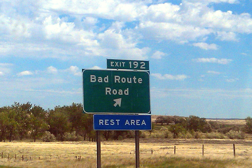
MOH sent this sign picture to me from eastern Montana, the sign being located on the eastbound lane of I-94 (Google Street View). I don't know if he visited the rest stop; other than that possibility, I know he didn't drive down the road to check it out. Bad Route Road may have been named after the nearby Bad Route Creek (which has a Bad Route Creek Bridge, and an East, West, and Middle Fork). There is also a Bad Route School.

As it turns out, this is the same sign that was used in the famous internet meme, "All Your Base are Belong to Us" (known as AYB or AYBABTU). The original shot of the sign, here, was turned into this sign, here.

All Your Base website [dead link].
All Your Base flash video.
All Your Base at Know Your Meme.
All Your Base at Uncyclopedia.
All Your Base video on YouTube:


I recommend watching the flash video, it seems a bit clearer.

The sign, and its partner on the westbound lane of I-94 (Google Street View), is also a bit of a meme in and of itself, having been posted on at least a couple blogs, and mentioned or linked to in threads about strange signs and strange placenames in the U.S. and around the world. Get your Bad Route Road e-card here!

Wednesday, June 20, 2012

American 101 Geo-Sites Meme

Callan Bentley has a new geo-meme up over at Mountain Beltway, based on the book 101 American Geo-Sites You’ve Gotta See, by Albert Dickas. I've bolded the ones on the list that I've seen.

1. Wetumpka Crater, Alabama
2. Exit Glacier, Alaska
3. Antelope Canyon, Arizona
4. Meteor Crater, Arizona
5. Monument Valley, Arizona
6. Prairie Creek Pipe, Arkansas
7. Wallace Creek, California
8. Racetrack Playa, California
9. Devils Postpile, California
10. Rancho La Brea, California
11. El Capitan, California
12. Boulder Flatirons, Colorado
13. Interstate 70 Roadcut, Colorado -- which one??
14. Florissant Fossil Beds, Colorado
15. Dinosaur Trackway, Connecticut
16. Wilmington Blue Rocks, Delaware
17. Devil’s Millhopper, Florida
18. Stone Mountain, Georgia
19. Kilauea Volcano, Hawaii
20. Borah Peak, Idaho - I've driven by, anyway
21. Menan Buttes, Idaho
22. Great Rift, Idaho
23. Valmeyer Anticline, Illinois
24. Hanging Rock Klint, Indiana
25. Fort Dodge Gypsum, Iowa
26. Monument Rocks, Kansas
27. Ohio Black Shale, Kentucky
28. Mammoth Cave, Kentucky
29. Four Corners Roadcut, Kentucky
30. Avery Island, Louisiana
31. Schoodic Point, Maine
32. Calvert Cliffs, Maryland
33. Purgatory Chasm, Massachusetts
34. Nonesuch Potholes, Michigan
35. Quincy Mine, Michigan
36. Grand River Ledges, Michigan
37. Sioux Quartzite, Minnesota
38. Thomson Dikes, Minnesota
39. Soudan Mine, Minnesota
40. Petrified Forest, Mississippi
41. Elephant Rocks, Missouri
42. Grassy Mountain Nonconformity, Missouri
43. Chief Mountain, Montana
44. Madison Slide, Montana
45. Butte Pluton, Montana
46. Quad Creek Quartzite, Montana
47. Ashfall Fossil Beds, Nebraska
48. Scotts Bluff, Nebraska
49. Crow Creek Marlstone, Nebraska
50. Sand Mountain, Nevada
51. Great Unconformity, Nevada -- have seen this in Grand Canyon, AZ
52. Flume Gorge, New Hampshire
53. Palisades Sill, New Jersey
54. White Sands, New Mexico
55. Carlsbad Caverns, New Mexico
56. Shiprock Peak, New Mexico
57. State Line Outcrop, New Mexico
58. American Falls, New York -- have seen American Falls, ID (ha!)
59. Taconic Unconformity, New York
60. Gilboa Forest, New York
61. Pilot Mountain, North Carolina
62. South Killdeer Mountain, North Dakota
63. Hueston Woods, Ohio
64. Big Rock, Ohio
65. Kelleys Island, Ohio
66. Interstate 35 Roadcut, Oklahoma
67. Mount Mazama, Oregon
68. Lava River Cave, Oregon -- other tubes, other places
69. Drake’s Folly, Pennsylvania
70. Hickory Run, Pennsylvania
71. Delaware Water Gap, Pennsylvania -- other water gaps
72. Beavertail Point, Rhode Island
73. Crowburg Basin, South Carolina
74. Mount Rushmore, South Dakota -- if I can't remember, does it count?
75. Mammoth Site, South Dakota
76. Pinnacles Overlook, South Dakota
77. Reelfoot Scarp, Tennessee
78. Enchanted Rock, Texas
79. Capitan Reef, Texas
80. Paluxy River Tracks, Texas
81. Upheaval Dome, Utah
82. Checkerboard Mesa, Utah
83. San Juan Goosenecks, Utah
84. Salina Canyon Unconformity, Utah
85. Bingham Stock, Utah
86. Whipstock Hill, Vermont
87. Great Falls, Virginia
88. Natural Bridge, Virginia
89. Millbrig Ashfall, Virginia
90. Catoctin Greenstone, Virginia
91. Mount St. Helens, Washington
92. Dry Falls, Washington
93. Seneca Rocks, West Virginia
94. Roche-A-Cri Mound, Wisconsin
95. Van Hise Rock, Wisconsin
96. Amnicon Falls, Wisconsin
97. Green River, Wyoming -- and Flaming Gorge, etc.
98. Devils Tower, Wyoming
99. Fossil Butte, Wyoming
100. Steamboat Geyser, Wyoming
101. Specimen Ridge, Wyoming

I've only got 24, with huge gaps in the east, central, and northern states.

Should be listed: Neguanee Iron Formation, MI.
Only one for AK?!
Monday, June 18, 2012

The Misty Mountains

Four weeks ago, we were driving west over Emigrant Pass on I-80 on our 2nd, and final, U-Haul van trip, when I noticed (I was in my newish jeep, and MOH was in the U-Haul) that the mountains and valleys of the northern Basin and Range were rapidly becoming obscurred by dust.
In this first shot looking southwesterly from a relatively obscure point on Bobs Flat, down Bob Creek toward the Horseshoe Ranch near Beowawe, NV, our view has been dusted, making the visible hills and mountains appear vague, as if lost in a morning mist. The prominent hill in the central part of the photo is a subrange of the northern Shoshone Range, and the cliffy north-facing side of the subrange is officially known as Malpais, but is usually called the Malpais Rim.

The Malpais Rim, site of The Geysers near Beowawe, NV, — the geysers are, sadly, no longer geysing — is "one of several east-northeast-striking, fault-bounded cuestas in north central Nevada" (Eric Struhsacker, 1980). In the photo, the north-northwest facing scarp of the Malpais Rim is facing just a little away from us toward Whirlwind Valley, the flat area on the right side of the photo. Beyond Whirlwind Valley, a farther part of the northern Shoshone Range has an unusually vague outline. We can't see the Cortez Mountains in this dusty view; they are usually visible beyond the Malpais Rim.
Here's our general location (map and link from The National Map, courtesy U.S. Geological Survey). [Btw, all the maps shown here will look better when enlarged by clicking; maps from The National Map can be explored more fully by following the link provided.] Carlin is near the east edge of the map, just west of the U.S. 40 loop through Carlin Canyon (this fairly ancient AMS sheet for the area shows I-80 as partially built, and Highway 40 still in existence before the completion of the Carlin tunnels). Battle Mountain is not far off the west edge of the map.
Zooming in somewhat (map courtesy U.S.G.S. but downloaded from a different part of their website, we can see Bobs Flat, the flat area in the upper center of the map (Highway 40, rather than I-80, is shown on this old 15-minute map), and Beowawe, the tiny town, ghost town, and ranch area on S.R. 306 in the lower left of the map.
Zooming in even farther, we can now finally see the area of The Geysers and the Malpais Rim (The National Map link). I've outlined Beowawe and The Geysers in dark cyan.
A little farther down the west side of Emigrant Pass on the descent toward the Beowawe Rest Stop — which used to be a great place to see The Geysers before their feeder geothermal exploration wellheads were plugged for geothermal production — we see two subparallel slopes comining southeastward off the Argenta Rim in the northern Shoshone Range, in front of the closer and clearer hills east of Whirlwind Valley. These closer, unnamed hills — irregularly north trending — sit between Bobs Flat and the northeast end of Whirlwind Valley.
The Argenta Rim (skewed rectangle) is another east-northeast-trending subrange of the northern Shoshone Range, similar to the Malpais Rim (The National Map link).
Coming into Battle Mountain, I grabbed this shot of the north end of the Shoshone Range near the Betty O'Neal mine in the Lewis silver mining district, in hopes of showing an alluvial fan slope coming off the mountains toward the Reese River Valley, but that slope is barely visible in this grainy, overprocessed photo. Nevertheless, you see the dusty conditions. This dust, and the dust we first saw coming over Emigrant Pass, is coming all the way from the Carson and Humboldt Sinks, located about 100 miles southwest of Battle Mountain and about 120 miles southwest of Emigrant Pass.
Coming around the usually blustery turn at Button Point, I had this view of the southern part of the Santa Rosa Range, with Bloody Run Peak being the high point on the left (south). The high part of the Santa Rosa Range — to the north, and off the photo stage right — was being thoroughly dusted by winds coming off the Black Rock Desert, and was not visible from I-80.

Our next view to the west, of Winnemucca Mountain, meant our second and last U-Haul trip was nearing an end, except for the unloading that took one more day — and except for the unpacking that is still in progress. A few views from Winnemucca Mountain, including one of Bloody Run Peak, can be seen here.

Selected Reference:
Struhsacker, E.M., 1980, The geology of the Beowawe geothermal system, Eureka and Lander Counties, Nevada: University of Utah Research Institute, Rept. ESL-37, 78 p.

Thursday, June 14, 2012

First Day Off After Nine

Early morning: This was my rousing view of clouds and the foothills of Winnemucca Mountain when I awoke this morning. This photo now seems to represent what was a somewhat inspirational beginning to what turned into a busy, erratic day. Perhaps the day was also a bit like the clouds: scattered.
Early evening: It was a hectic day, seemingly, and I'm finally relaxing with a cold beer — a Rotator IPA in a Ruby Mountain Amber pint glass. I think the only reason the day seemed hectic was that I did things other than what I planned, things that weren't on my TTD list, so I felt as though I didn't accomplish anything. Instead of relaxing and blogging (both were on the list), I did a modicum of unpacking, a bit of arranging, and quite a bit of rearranging. I did get two things on my list done, including having a relaxing hot bath. And, for things not on the list, I accomplished the hanging of a peg strip near the front door of the apt, which now looks like this (sign compliment of furnished apt):
By the end of the day, prior to beer, I didn't find a Father's Day card to my liking. Whereas it seemed that the cards in our moved-away-from town were dorky and quite repetitive year to year, it seems as though the cards in this new town, while ostensibly or superficially quite varied, trend overall either toward the overly sentimental (for either myself or the way I view my dad), or they are raucous musical and noisy things that I'm pretty sure he wouldn't like. Consequently, because I'm already late in mailing anyway, I'll probably dig through the many cards I have on hand, which I've bought for myself not to use but to look through and enjoy (art cards), then I'll pick one out and hopefully get it sent by tomorrow afternoon when the mail gets picked up at our nearby apt-based boxes. With any luck, the card will arrive in AK by Monday, only one day late.

In the meantime, I'm expecting a phone call from MOH. He's on his northern adventure, checking out oil fields and small towns in northerly areas that I've never visited. (I'm jealous, in a way, but am getting daily pictures of campsites, rivers, and the way my old truck currently looks as a mini-RV. One thing I've learned is that the Yellowstone River is quite beautiful, though a long way from here.)

And now, my beer is still cold but needs to be refreshed with a new one, the sun coming through the open-to-the-freeway window — open to let swamp-cooler air on high out — is warm. After beer I'll have a dinner either of mint chocolate cookie ice cream or mini-ravs and milk. That will be the end to what I now see as a good day.

P.S. The "our town" tag refers to the old place in the hinterland of eastern Nevada, and the "wnmca" tag refers to a uniquely named town in north-central or north-western Nevada (depending on how you view Nevada geography).

P.P.S. I am finding myself, as I've mentioned before, considerably shorter on time for blogging while working the industry-wide normal 10-hour days and having a door to door driving/riding time of 45 to 60 minutes, depending on particular logistics. These logistics create what are actually 12 hour days, longer than my previous 10-hour work days plus 30 to 45 minute max round trip times (10.5 to 10.75 hour days compared to ± 12 hour days). I'm still adjusting, rather slowly, to my lack of blogging time. I'm not awake enough in the morning to do much serious (or very good) writing or link finding, and the short evening is often crammed with brief winding down, dinner, getting ready for the next day, enjoying a netflix-streamed old TV series episode or two with MOH when he's here, OR just crashing, OR reading the internet but not blogging. Haven't figured all that out quite yet — and I haven't quite scheduled time in for any excercise besides what I get at work, walking up and down metal-grated stairs and walking back and forth down my rubber-padded cement-based core-logging lane.

P.P.P.S. Wrist and elbow overuse pain (started in one arm, is now also in the other becuase of using the other almost exclusively at times) has also limited what I have been able to do on the computer. The pain, soreness, inflammation, whatever it is, is better. It all probably began from packing and lifting/carrying boxes; consequently, any unpacking I do puts me at least slightly at risk of a longer healing time. (RICE: REST, ice, compression, elevation — need the former, acheiving very little of the latter - how does one raise the elbow without using it or other possibly compromised muscles? Meh.)

Monday, June 11, 2012

Hummingbird Moth in Chocolate Mints

Yesterday I received an email while at work telling me that there was a hummingbird moth in one of our two pots of chocolate mint, which are sitting outside on the front porch. MOH thought the moth might still be there when I got home, and sure enough, it was.
It didn't move when I approached as close as I wanted with my camera, but it was dark in the shade of the mints, and several pictures were a little blurry.
Here's its cute little face, sharpened somewhat by photo processing.

This is the same kind of moth (Hyles lineata) as seen here between Goldfield and Beatty, Nevada, about three years ago, and these are the same mints that came from overseas and made a first appearance on the blog mid-summer of 2009. The mints have been subdivided and passed around amongst family; the moth has moved on. This particular type of hummingbird moth tends to be nocturnal, so maybe it was just in the mint to sleep for the day.