Friday, October 18, 2013

Across the West and Back Day 2: Are We Lost Yet?

We left this meandering trip report almost two weeks ago, after MOH and I had taken our short hike into the limestone at the Grassy Mountain Rest Stop. From there to Salt Lake City, we cruised while admiring the shorelines of ancient Lake Bonneville.

Lake Bonneville shorelines in the southern Lakeside Mountains, looking northeasterly from I-80 about five miles northwest of Delle, UT.
And then: Salt Lake City.

Driving into SLC can make me somewhat apprehensive unless I'm going directly to the airport, and I had already started wondering if I was getting a migraine — possibly from normal trip concerns, possibly from driving, maybe from poor sleep the night before, possibly from some other, unknown cause.

I had looked at our route on Google Maps and had looked at the interchanges and major turns in Street View. Examining the route online is not the same as having a physical map in hand while driving (or in the navigator's hand, as the case may be) — at least not for me, or at least not unless I have some ingrained or recent familiarity with the particular roads in question. The last time I'd driven (or been driven) east through SLC without turning onto I-15 to go either north or south was in 1957 when I-80 didn't exist — and the 1957 trip definitely didn't count as recent, maybe more like Ordovician, or even late Precambrian.

I knew I was looking for the turnoff from I-80 to U.S. 40 — not that far past SLC, I thought — but I don't think I'd written down the miles to the exit, and I know I hadn't written down the exit number. And for some mysterious reason I was thinking that Park City (which I've never been to, except possibly on that long ago 1957 trip) was a lot closer to SLC than it really is.

Consequently, when the interstate turned a bit to the northeast and headed upward into the fairly tight canyon of Parleys Creek, I instantly freaked and thought it was the even narrower Echo Canyon, which I remembered from coming west out of Wyoming on I-80 on a 2006 trip. I was sure I didn't want to be heading into Wyoming on I-80, so I thought I must have missed the desired exit up somewhere near Park City (!).

I turned around at the first opportunity amidst a rash of roadwork, blocked exits, and narrowed lanes.

I knew I needed a map, so we got off at what turned out to be Exit 4 on 215. We pulled into a gas station and got some gas and a relatively small scale map of Utah. It was at this point that I was sure I had a migraine — and migraines do this funny thing to your overall thinking and analysis skills.

After examining the map while experiencing fairly moderate noise, light, and motion sensitivity that caused me to have problems looking at the map and then looking anywhere else, like at the road, I decided we were on an "outer" loop around SLC that I was previously unaware of. (This "outer loop" actually consisted of I-84 from Ogden, east and southeast to I-80 at the beginning of Echo Canyon, and south and then back west into SLC on I-80, but that part of I-80 wasn't marked, neither was 215 marked, and the insert for SLC was surprisingly small and lacking in detail.) We were actually at a gas station along the 215 partial ring road, and I probably knew that fact when I had turned on to it after turning around in Parleys Canyon.

I figured all we'd have to do was get back onto this previously unheard of "outer loop" and head east or south to our desired exit onto U.S. 40 near Park City. Wrong.
The map in question.
By this time, MOH had wisely taken over the driving while I endeavored to determine our exact location. With a blur of freeway lanes, cars and trucks, and exits coming too fast to comprehend (this should have given me a clue), what I was seeing on the map (how could Alta and Snowbird already be north of us?) wasn't matching the route I'd incorrectly figured was the one we were on, and it wasn't matching my still intact knowledge of where we really were along the Wasatch.

Suddenly, the "outer" ring road turned due west, and I knew something was very wrong. I realized where we had to be (on the "inner loop" road, i.e. 215) just in time to navigate properly and direct us onto the exit for I-15 south. Whew!

At this point, we thought it would probably be just as easy to take the next road south over the Wasatch than to turn around and go back for I-80, Park City, and U.S. 40. As for this thought: not exactly correct.


View Our Crazy Route through SLC in a larger map

Because we went (unexpectedly, for sure) south on I-15, I was able to get a pretty decent, albeit somewhat grainy, shot of the Bingham Canyon copper mine.
View of the Bingham Canyon copper mine, looking west from I-15.
It has been quite a while since I've been to Bingham Canyon — and I've never had a tour into the pit itself — but I strongly recommend going to the overlook and Visitors Center (the latter of which I've never seen) when they are reopened. The overlook area has been closed since the April 10th landslide (see a pre-landslide panorama of the pit here, view Kennecott's photos of the slide here, and read about the slide on several blog posts by Dave Petley).
Looking east toward American Fork Canyon.
And so, with our most recent trip decision finally behind us, we proceeded down I-15 to the Utah S.R. 92 exit, onto 92, and into the Wasatch via the easy, wide-looking American Fork Canyon.


View Day 2: Elko, NV to Vernal, UT in a larger map

The embedded map above shows the location of the three photos in this post (and also the rest of the Day 2 photos already posted, if you move around inside the map or view it in an enlarged version).

Related Posts:
Across the West and Back Day 2: A Hike along a Limestone Ridge
Across the West and Back Day 2: Across the Salt Lake Desert
Across the West and Back Day 2: A Side Trip in West Wendover
Across the West and Back Day 2: Pequop Summit to West Wendover
Across the West and Back Day 2: Looking for an Old Roadcut
Across the West and Back: The First Day
Intro to Recent Western Loop Trip

Monday, October 14, 2013

Earth Science Week 2013

Earth Science Week, organized yearly since 1998 by AGI, began yesterday. This year's theme, "Mapping Our World," is designed to highlight "the many exciting uses of maps and mapping technologies in the geosciences."

For my small part this year, I noticed a map at ESW that shows links to a Google Maps map showing earth science organizations for each state. The one for Nevada, for example, can be seen here.

I went a little bit farther and added each organization and location on the map (generated originally by user ESW, Earth Science Week) to a map of my own, to which I added a few other organizations. That map is embedded below.


View Nevada Geological Organizations in a larger map

I was working on this post last week, when at some point my computer or browser or both went into overload or freezing mode, and I had to reboot, somehow losing the draft of the post in the process. I had added only a few Nevada geological organizations to my embedded map; all the ones I added consist entirely of statewide and chapter meeting places of the Geological Society of Nevada.

The GSN website has a large number of geological links — to state, U.S., Canadian, and other foreign geological surveys, to various professional organizations, and to various State of Nevada departments and divisions. You will also find many other geological links, including several for the USGS. I had started to add the location of the USGS Nevada district office to my map, when I realized my small but increasingly time consuming project had been put in jeopardy by the U.S. government #shutdown. I couldn't find out where the district office in Nevada is located! (The district office referred to may be the USGS Nevada Water Science Center office in Carson City rather than a geologic field office, not sure.) Instead of the website linked to at this URL, I got the main USGS page and the following announcement:

Current USGS main page, retrieved 14Oct2013.
In any case, check out the other geological links at the GSN. And check out their interactive map showing locations in Nevada where their publications (mostly field trip guides from the many GSN symposia and biannual to yearly field trips.

Thursday, October 3, 2013

Across the West and Back Day 2: A Hike along a Limestone Ridge

Where were we? Oh yes, it was *still* day two of our giant western loop trip (as I have so fondly labeled it), and we were at the Grassy Mountain Rest Stop, and we were about to take a hike through a bit of limestone.

The first stop on the short hike is a small window in limestone of the Pennsylvanian Oquirrh Group that may be equivalent to some part of the Ely Limestone (judging by its air-photo outcrop pattern alone — I haven't looked for diagnostic fossils). The online, interactive Utah geological map isn't specific to formation in this part of Utah.
Small window in limestone, looking south.
Same window looking back toward the rest stop, with MOH's hand for scale.
View to the west or southwest from our limestone ridge.
While hiking along the trail, the portion of the Great Salt Lake Desert that we crossed between Wendover and the rest stop was just barely visible through the haze. It's not that first white line out there before the rocky hills in shadow; it's the vague flat area beyond the shadowed hills on the right.
The trail continues to the south between two ribs of limestone, amidst the cheat grass and halogeton.
The view looking south toward unnamed hills, also underlain by Pennsylvanian limestone.
Pack rat midden in tiny cave.
We speculated about the formation of the limestone window, and wondered if something as mundane as a packrat's midden could have contributed to creating a small cave in the limestone, with uplift and erosion later leaving the window isolated from most of the exposure.
Trail's end. A part of the Cedar Range in the distance on the left; the unnamed hills seen earlier on the right.
Once again I've added the locations of these photos to the day's trip log (map) embedded below.


View Day 2: Elko, NV to Vernal, UT in a larger map.

Monday, September 30, 2013

Across the West and Back Day 2: Across the Salt Lake Desert

MOH and I left Nevada and entered Utah shortly after getting back onto I-80 following our brief sojourn in West Wendover, and began crossing the Great Salt Lake Desert (and Bonneville Salt Flats).

When almost to milepost 16, I took an obligatory photo of Floating Island, no doubt named for the mirage that often makes it look like it's floating above the salt flats. Here, the mirage is minimal but present. (See better photos of Floating Island with strong mirage here.)
Floating Island.
It turns out that Floating Island *may* be at least partly underlain by our old friend, the Ely Limestone — or perhaps it's underlain by a Utah equivalent, the Lake Point Limestone, or another Utah equivalent, the Erda Formation. On the interactive online Utah state geologic map, clicking reveals that Floating Island is listed as being underlain by the Oquirrh Group (with the symbol PP - Pennsylvanian undivided?), consisting of such formations as the "Wells, Weber, Ely, Callville and other Fms" — at the same time, the map shows the symbol PPe on the northeastern side of Floating Island. PPe is the usual symbol for the Ely Limestone in eastern Nevada, but perhaps it could also refer to the Erda in Utah. For me, the island is too far away to make any snap judgements!

It was a cloudy day, overall, but nevertheless you could see a good 90 miles to the far peaks.
Looking ESE across the desert at the Cedar Mountain, and the crest of the Stansbury Mountains beyond that.
It became clear about halfway across the desert that distances were more than usually deceptive. The eastbound road markers on I-80, which begin with milepost 1 exactly one mile east of the NV-UT border, essentially mark the distance you have travelled across the desert from its western edge at just east of West Wendover, NV (in fact, you travel almost exactly a mile from the state line before ramping down onto the flats). Just before milepost 21, we passed a road sign indicating that it's 22 miles to the Knolls. The Knolls exit is just past the eastern edge of the salt flats, so I knew we were just almost exactly half way across.


View Approximate half-way point in a larger map.

It seemed like we had been driving forever! The low hills in the distance, marking the other side of the desert, only looked about 8 to 12 miles away, though they were really about 21 miles off. We knew we had another "almost forever" still left to go!
Milepost 39: Finally we were approaching the east side of the broad, flat crossing.
Exit 41, Knolls, one mile past the first sand dunes at the east edge of the desert. Milepost 40 is visible in the photo, not far beyond the exit sign.
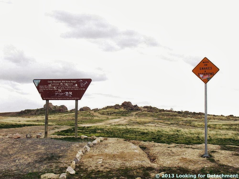
At the exit for Knolls (a siding? some hills?), we knew we were getting close to one of our favorite rest stops, Grassy Mountain. The rest stop is known for a short hiking trail and a sign saying "Watch for SNAKES and SCORPIONS."
Despite this sign, I've never seen any of either...
...although we did see a horned lark noshing on a pretzel.
More commentary has been added to a second warning sign.
The second sign says, among other things, "DANGER: Sex, Sleds, and Snowboards."
Finally, on a day perhaps as cloudy as the one shot here in 2011, we started out on a little leg-stretching expedition.
And I'll have to save the hike for another post...

Photos to this point in Day 2 have been added to the day's trip log on Google Maps, along with the ones from West Wendover, which I forgot to add after the last post:


View Day 2: Elko, NV to Vernal, UT in a larger map.

Related Posts:
Across the West and Back Day 2: A Side Trip in West Wendover
Across the West and Back Day 2: Pequop Summit to West Wendover
Across the West and Back Day 2: Looking for an Old Roadcut
Across the West and Back: The First Day
Intro to Recent Western Loop Trip

Tuesday, September 24, 2013

Across the West and Back Day 2: A Side Trip in West Wendover

As I mentioned in my last western loop trip post, when West Wendover, NV, came into view, it became clear that the section of I-80 that we were on was identical to the route of old U.S. 40. We got off the freeway, not specifically to drive that section (there are a lot of sections of old 40 in Nevada that we haven't driven yet), but to get some items we needed for the trip. We found ourselves on West Wendover's main street, West Wendover Boulevard, AKA old highway 40 (unsigned).
West Wendover Boulevard, looking west.
As we progressed down the street, off in the distance we could see what looked like a giant cowboy.
Is that a giant cowboy in the middle of the street?
Yes, indeed! It's "Wendover Will," welcoming you to West Wendover, Nevada — although why he's doing that on the far west end of town is unclear to me.

We drove around Will toward the Smith's, our destination, and could see old 40 heading straight for I-80 where it goes through an unnamed notch in the southern Leppy Hills.
Decommissioned U.S. 40 heading west out of West Wendover for I-80.
We bypassed driving farther on this section of old 40 in favor of more easterly destinations, turned around after our needed stop, and left Nevada for the salt flats of the Great Salt Lake Desert and Bonneville Salt Flats.