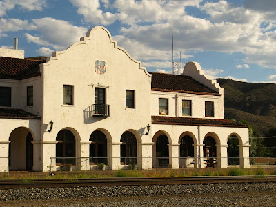
 I just got back from a short trip to Caliente, Nevada. The weather was looking good when I headed down there, with temperatures predicted to be slightly lower than average, especially if clouds like these stayed around. This photo is from the early evening of the day I arrived.
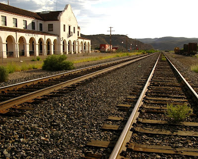
 Caliente is a railroad town. Its mission-style railroad station is now being used for city offices, library, and other civic-type functions. This photo looks south down the railroad tracks, and shows the Boxcar Museum, painted bright red-orange, beyond the railroad depot. Supposedly "officials at the depot frown at people crossing the tracks" to get to the station, but I was assured by someone at the Shady Motel that it was okay, although I didn't see anyone else doing it.
 Nevada Historical Marker 249 is on the north side of the railroad depot. Although the sign is stamped 248, apparently two were marked 248, and this one is called 249 on the official list. Text is here.
 By the morning of the first field day, thick smoke had moved into the area, supposedly from big fires in Utah. Colors were consequently a little yellowish to reddish, and a bit dulled. You can see an anemometer and some other equipment behind the lampost and to the right of the tree, on the northwest corner of the walkway surrounding the railroad depot.
 The anemometer is part of the Caliente Community Environmental Monitoring Program (CEMP) weather station. The only place I could find readouts for this CEMP station was at the Weather Underground. All other online weather reports for Caliente appear to be extrapolations from the usually hotter cities of St. George and Las Vegas.
 The main readout panel shows a typical early morning temperature of 58° F (about 14° C).
 Temperatures after daily field excursions were usually in the 93° to 95° F range (about 34° to 35° C). That was hot enough for me!
 This is a sunset photo, taken in the evening after the first field day, with most of the old main part of town in the lower right. Smoke was thick through the first field day and through the afternoon of the second field day, when the skies cleared and views improved.
 On the evening after my second day in the field, smoke moved in again, apparently from the east.
 The sun looked like this in the early morning on the day I left, red from the smoke.
Related Posts:
Map Area in Meadow Valley Wash
Our Camp in Meadow Valley Wash
Note: As pointed out by @FlorianBoyd, the Kelso Train Station is similar to the Caliente Depot, and is also on the same Union Pacific rail line.
Update: DRI has a map of all their CEMP weather stations here, as pointed out by ChrisM in the comments.
8 comments:
Cool pictures. Do you know what the units, "ly" are in the solar radiation read out? Also, I took the second picture and made an interesting illusion with it. Curious if you perceive it as I do.
The units are Langleys, described here = 11.622 Watt-hours per square meter = 41.84 kilojoules per sqare metre
= 3.687 BTUs per square foot.
The CEMP program is run by DRI, and is further described a bit here. The readout for the Caliente station shows the solar radiation in Kw/m2.
Have commented on the illusion on your blog. Neat!
I like the old depot. Too bad it's still not a hotel. The smoke is not good in many places. It's been thick at the canyon from LA and was visible from St George today. Does make for colorful sunsets.
Yes, I have a bit of an update about the source of the smoke blanket in Caliente, on my next post. Seems that it was mostly from the Station Fire in CA, despite local supposition about fires in Utah. Hope it all clears soon!
I see you already found a readout, but DRI's site has a nice little map and realtime gadget.
http://cemp.dri.edu/cemp/
Funny thing about the train depot that an NRCS guy told me who used to live other there (he actually did a lot of the initial soil mapping in Delmar Valley, Pahroc Mts), was after it was built, Caliente thought they would be all clever and jack up taxes UP would have to pay. UP basically said, fine, we don't need you, and never really used the depot all that much. So Caliente got screwed in the end.
So maybe Caliente isn't a railroad town, afterall! -And thanks for the link. I've added it to the post.
WeatherBug has a weather station located at Caliente Elementary School (with a Camera)
Thanks for the info, Thayatt.
Post a Comment