 In our last episode of the long saga of going to Oregon, hanging around, and then coming back, we had just left Paisley, where we had breezed through without stopping for the Annual Mosquito Festival. Past Paisley, we continued southeast on Oregon Route 31 toward our primary goal, the Winnemucca-to-the-Sea Highway. Prior to that turnoff, however, and only some ten miles down the road, we entered a freshly graveled stretch of pavement that points straight at The Narrows of the Chewaucan River (MSR Maps).
This is a good stretch of road for viewing a little geology. Near Milepost 107, you can catch a view of the ancient shorelines that wrap around the north side of Tucker Hill, a smallish, talus-covered and rocky butte on the south side of the highway.
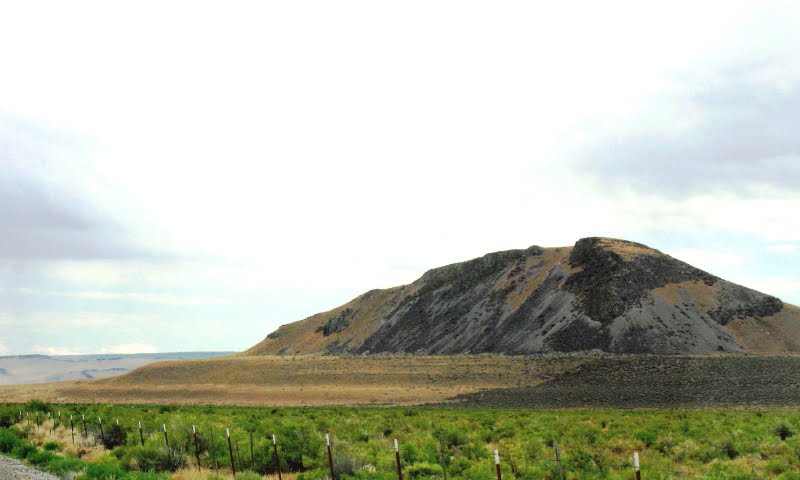 These shorelines are from pluvial Lake Chewaucan, the remains of which now consist primarily of Summer Lake and Lake Abert. Lake Chewaucan reached an elevation of about 4500 feet at its high stand, the elevation of the highest terrace seen here.
For a much better view of the shorelines on Tucker Hill, see Andrew Alden's Outback Oregon Gallery (or take a road trip).
 This little map, a modified version of this map, shows the extent of pluvial lakes in southern Oregon and will enlarge when clicked. I've highlighted Lake Chewaucan in bright periwinkle blue. The full extent of late Pleistocene pluvial lakes in the Great Basin can be seen here as Figure 13. Also see this pdf map of Pleistocene lakes in the western Great Basin; the map doesn't name Lake Chewaucan but shows its area.
 Continuing along to the southeast, somewhere near Milepost 113 you will see one or two basalt dikes to the northeast. I managed to get a picture of the dike closest to the highway. It cuts vertically through basalt flows and intra-flow sediments, here showing a less than 90 degree apparent dip because we aren't looking straight down the strike of the dike. To look straight down strike, you should stop somewhere between MP 113 and MP 114.
This dike may be a feeder for the basalt flow capping the lower ridge: on Google Earth and Google Maps, it looks like the dike fails to cut through to the overlying flows.
 Right at Milepost 114, you'll look almost perpendicular to the trace of the highway to see this view the dike. The second dike should be visible at this point, almost due north of the first and a little farther back in the hills. To get a closer look, try taking a dirt road that heads north and passes near the lower part of both dike outcrops. I won't, however, guarantee the condition of the dirt road — it's been many years since I passed that way, and who knows? For this trip, we just zoomed past in the Prius.
Also worth noting: more ancient shorelines are visible in the low rise to the right of the dike. In fact, shorelines abound throughout the area.
Some References:
Reheis, Marith, and Bright, John, 2010, Late Quaternary Paleohydrology of the Mojave Desert: U.S. Geological Survey, Geology and Environmental Change Science Center, page last modified on 15-Apr-2010 13:38:29 MDT.
U.S. Geological Survey, and Reheis, Marith, 1999, Extent of Pleistocene Lakes in the Western Great Basin: U.S. Geological Survey Miscellaneous Field Studies Map MF-2323, U.S. Geological Survey, Denver, CO.
View Bend OR to Winnemucca NV in a larger map
To be continued... onward to the Winnemucca-to-the-Sea Highway!
2 comments:
I really enjoy your geology lessons and photos of a landscape I haven't seen in a very long time. Makes me want to take to the road. ;)
Thanks! Hope you can. :)
Post a Comment