Getting
past Tan Mountain on the trip down the Titus Canyon road always feels like a milestone to me, not so much because the road gets better—it maybe does get better, for a while, or maybe I just get used to the washboard—but because I've finally made it past the Amargosa Desert into the Grapevine Mountains. (The Grapevine Mountains are part of the much larger
Amargosa Range, the mountains that essentially bound the east side of Death Valley. See the image after these two bush photos.)
On this section of our trip, we are not actually
in Titus Canyon: We are in some unnamed wash that drains eastward into the northwest part of the Amargosa Desert. Beyond "White Pass," we will at first be in the upper reaches of Titanothere Canyon,
still not in Titus Canyon.
 |
| A close-up of the same bush, showing the silky, tent-like mass in its branches. |
I suspect this bush, growing beneath
the hoodoos of Tan Mountain, is
Purshia stansburyana (formerly
P. stansburiana) rather than
its close cousin P. tridentata—Lengner and Troxel (2008) show pictures of this bush growing along the road near Tan Mountain. It's hosting what they identify as the caterpillars of the Fotis hairstreak (
Callophrys fotis).
 |
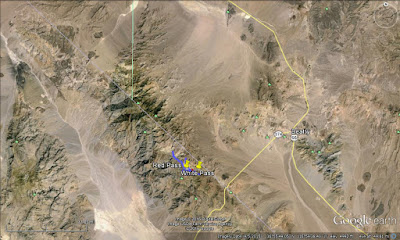
| Google Earth image of the Grapevine Mountains with a few labels. |
Well, I've torqued this G.E. image around quite a bit, so that the long dimension is parallel to the NW-SE California-Nevada stateline. I've added a crude outline of the Grapevine Mountains, the portion of the larger Amargosa Range that runs essentially from the Daylight Pass Road on the southwest (far left boundary) to Scotty's Castle on the northwest (far right boundary that has tailed upward). The odd shape of the mountains on the right occurs because at about
Grapevine Peak, the mountain range as named on maps splits in two, with a little tail running WNW toward Scotty's Castle in California, while the main part of the range runs ENE toward Bonnie Claire and Scotty's Junction in Nevada. If you look closely, I've marked White Pass and Red Pass, and a couple faults. (I hope to talk about these faults in a later post.) If I hadn't torqued the image, it would have looked like this:
 |
| (No labels on this one, though.) |
"White Pass" as a name is well established in Titus Canyon and Death Valley lore: It's mentioned
on several websites, including the
NPS's page about Titus Canyon, although it's shown on zero maps (that I could find) and is not listed as a place name
by the USGS. Consequently, you not only get a location on the Google My Maps map way below, I'm giving you the location on a topo map:
 |
| Location of White Pass and other key localities, courtesy USGS TNM 2.0 Viewer. Labeling done in MS Paint. |
White Pass will mark another official milestone on our journey: We will enter the realm of
this fairly detailed geologic map. Yay!
Between Tan Mountain and White Pass, the road runs south of several smallish dark brown hills composed of brown volcanic rock above white to pale yellow sedimentary rocks, often tuffacaceous, with intercalated tuffs. The brown, hill-capping formation has been mapped as Tlt, Lithic Ridge Tuff and related felsic rocks, by Workman et al (2002) and as part of Tw, the newly defined Wahguyhe Formation, by Niemi (2012). So it's a little confusing, but with a little research I determined that these brownish cliffs are indeed what has been called a latite flow before (Lengner and Troxel, 2008), with Niemi saying that the latite (he included it in the Wahguyhe) correlates with the
Rhyolite of Picture Rock, which is rhyodacitic to latitic. So, when you look north at the dark brown caps, think rhyodacite to latite!
 |
| Dark brown latite flow rock caps a hill north of the road. |
 |
| I took this zoomed-in photo mostly because of the interesting patterns in the talus coming from our dark brown latite flow on the right (and, the sky!). |
Moving on, we arrive at White Pass, where we can now see into the northeasternmost part of Titanothere Canyon.
 |
| We're looking west from White Pass. The dark rocks to the left (S) are Cambrian; the rocks to the right (north) and straight ahead (W) are Tertiary. |
At White Pass, and in fact all along the road from about a mile past Tan Mountain, rocks to the south are all Cambrian while rocks to the north are all Tertiary.
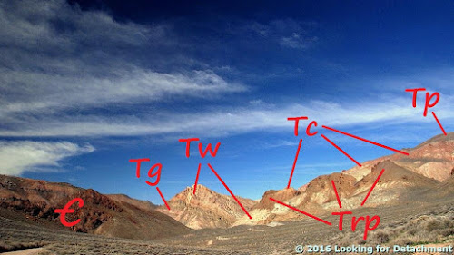 |
| The same photo, labeled with geologic formations (the Tertiary as shown is all from Niemi, 2012). |
We'll see more of the Cambrian in a bit. The Tg is the Panuga Formation. Probably some of you will notice that this greenish unit has been included in the Titus Canyon Formation before. We'll see more of this unit on the way to Red Pass, and maybe we'll figure out whether it's Titus Canyon Formation or not. The Wahguyhe Formation (Tw) includes various sedimentary and volcanic units, including sandstone, shale, conglomerate, and tuffs. In places, the Trp, Rhyolite of Picture Rock, often described as a latite flow, is included in Tw. Here I've broken it out as best as I can (and hopefully, correctly!). Overlying the Tw and Trp are various tuffs, mostly ash-flow sheets from the southwest Nevada volcanic field, including those in the Crater Flat Group (Tc), the Paintbrush Group (Tp), and the Timber Mountain Group (Tm, not shown in these photos). All these Tertiary formations are Miocene in age (Niemi, 2012).
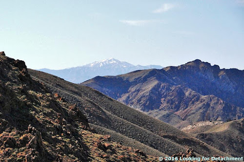
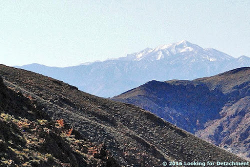
Before leaving White Pass, we'll look off a little to the south. These two photos were taken about 7 years apart from almost the same spot. The lighting and clouds are a bit different, the time of day is nearly the same.
 |
| Photo taken at about 10:00 am in late February, 2016. |
 |
| Photo taken at about 10:30 am in early May, 2009. |
I guess I'm often inspired by the same rocks and the same angles! The photos both show
Thimble Peak (6,381 ft, 1945 m), the thimble-shaped peak on the far left. The dark gray rocks in the foreground on the left are in the Bonanza King Formation; the dark reddish brown rocks in the foreground, center and right (in shadow in the 2nd photo), consist, I think, of the Zabriskie Quartzite; and the layered rocks in the distance consist of the Bonanza King Formation (the gray on Thimble Peak and the dark gray capping the ridge to the right of Thimble Peak) overlying the brown, reddish brown, and gray Carrara Formation. These formations are all Cambrian in age. The normal sequence is Zabriskie overlain by Carrara overlain by Bonanza King. On Google Earth, it looks like the Bonanza King and Zabriskie in the foreground are juxtaposed by a fault.
Okay! Let's move along! We've got to get through this canyon before...well, you're not supposed to camp in the canyon: It's
day use only!! (This is really too bad, IMO; there is way too much to see along this road in one day.)
Here's another place I always end up stopping: on the road between White Pass and an unnamed pass between the two branches of upper Titanothere Canyon. We'll turn and look south down Titanothere Canyon.
 |
| The alluvial fan in the distance is across Death Valley, beyond Stovepipe Wells. |
 |
| At about the same point on the road, also looking to the south,you'll see Telescope Peak. |
 |
| Telescope Peak (11,048 ft, 3367 m) is about 45 miles distant in this shot! |
Next time, maybe we'll make it to Red Pass!
A Few References:
Lengner, K., and Troxel, B.W., 2008,
Death Valley's Titus Canyon & Leadfield ghost town: Deep Enough Press, 175 p.
Niemi, N.A., 2012,
Geologic Map of the Central Grapevine Mountains, Inyo County, California, and Esmeralda and Nye Counties, Nevada: Nevada, Geological Society of America Digital Maps and Charts Series, DMC12, 1:48,000,
28 p. text.
Workman, J.B., Menges, C.M., Page, W.R., Taylor, E.M., Ekren, E. B., Rowley, P.D., Dixon, G.L., Thompson, RRA., and Wright, L.A., 2002,
Geologic map of the Death Valley ground-water model area, Nevada and California: U.S. Geological Survey Miscellaneous Field Studies Map MF-2381-A,
Pamphlet text,
Sheet 1,
Sheet 2.
Location map
Related Posts:
Beatty: Old Buildings, A Fold, and Onward toward Titus Canyon
The Approach to Titus Canyon: Amargosa Narrows, Bullfrog Pit, and the Original Bullfrog Mine
Mineral Monday: Close-Ups of Bullfrog Ore from the Original Bullfrog Mine, Nevada
The Approach to Titus Canyon: Tan Mountain


No comments:
Post a Comment