
Moving on with my road trip up to last month's GSA meeting in Portland, my next stop past
Annie Creek was
Crater Lake itself. The east and south parts of the rim road were closed, but the exit out the north was open (currently all but the entrance from the south to the Rim Visitor Center are closed). I haven't been on the north exit/entrance to the park for a long time, and the sidetrip off Highway 97 added only a few extra miles (although also a couple extra hours!). The gray photo is from the
Crater Lake webcam earlier this morning - normally you can see across the lake from this location.
The first five photos were taken from
three stops here, which are all very close together on the West Rim Drive.

This is a fairly standard photo of Crater Lake, with Wizard Island in the west part of the lake, and Llao Rock on the crater rim beyond.
Wizard Island, an andesitic cinder cone, formed about 7,200 years ago (
Bacon, 2008 and
Cranson, 2001/2002).
 Llao Rock
, the massive cliff on the crater rim behind Wizard Island, is a rhyodacitic dome, with a flow beneath the clouds to the right, that erupted about 200 years before the climactic eruption of Mt. Mazama. The whitish layer beneath Llao rock is an air-fall ash and pumice layer from an eruption just prior to formation of Llao Rock. That explosive eruption about 200 years prior to the climactic eruption produced
a widespread ash bed found in northern Washington, southeastern Oregon, and western Nevada, where it was called the Tsoyawata Bed by J. O. Davis before it had been correlated back to its source at Crater Lake (Davis, 1977; Davis, 1978; Bacon, 1983; Davis, 1985).

As usual, the water of Crater Lake was exceptionally blue.
If you make it to Crater Lake when most of the roads are open, be sure to take the
boat tour out to Wizard Island (the hike down - and then back up - the crater rim to the Cleetwood Cove boat dock is steep and rocky). After landing at Wizard Island, you can climb the cone to the top, where the trees are fascinating, and where you can also see the cinder cone crater. Then you can get a later boat back to the Cleetwood Trail.

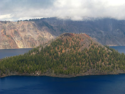
This photo looks across the lake at the west side of Wizard Island, where an andesitic flow reaches toward the west crater wall. The
Devil's Backbone can be seen across the flow on the rim beyond, just right of the low mass of trees. This is an andesite dike - the andesite of Devil's Backbone - going up the crater wall (enlarge photo - the upper part of the dike appears to be in shadow). The dike cut through the older rocks about 4,000 to 5,000 years ago (
Bacon, 2008).

At stop three (
centered here on Google Maps), I looked across the lake toward
Cloudcap, which is mostly in the clouds, and I noticed something a ways to the left of it, on the crater wall.

That something can barely be see in this photo, between the trees on the far side of the lake.

Here it is, enlarged a bit, a light-colored line on the opposite crater wall.

It's
the Wineglass, after which the Wineglass Tuff was named! Enlarge the photo, and you'll see that the Wineglass is a wineglass-shaped talus slope beneath a layer of Wineglass Tuff (aka Wineglass Welded Tuff of Williams, 1942). Just to the left of the Wineglass is a prominent cliff called
The Pallisades, formed by the andesite of Roundtop, which has a K-Ar age of 159±13 ka (
Bacon, 2008).

Okay, now I've moved on to
stop 4: "Danger Will Robinson!" - and what geologist could resist going beyond this sign? (Another photo of the lake and Wizard Island, ho hum.)

Instead of obeying the sign, I followed my geological instincts to this cliff edge, where I found some great glacial striations and grooves on some lava rock (possibly the andesite of Applegate Peak, which has a K-Ar date of 258±8 ka to the south -
Bacon, 2008). The grooves point approximately toward the Wineglass - a northeasterly direction.

Here's an enlargement of the grooves and striations, with a field sandal for scale. It looks to me like the ice was moving to the southwest (lower right in the photo), but I didn't examine the outcrop in detail while there.

The nature of the day was apparent at the
Watchman Overlook, where many were standing around waiting for the mist to clear.

The mist came and went, ebbing and flowing, finally clearing for a clear view of Wizard Island. You can see the crater of the cinder cone in this photo, along with an andesitic flow that erupted from vents near the base of the cone. The flow comes almost to the edge of the lake at the Watchman Overlook.

While watching the mist come and go, I took a few photos toward Llao Rock, and just happened to get a bit of the Devil's Backbone in the picture, just beyond the dark foreground mass, in the mist near the water's edge.
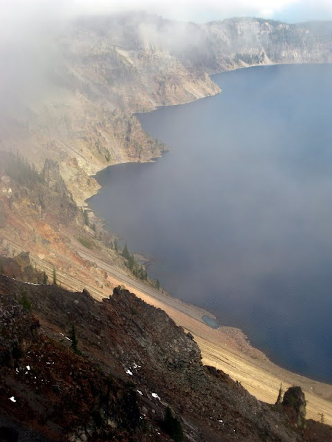
Here you can see the lower part of the Devil's Backbone dike, beyond that darkly shadowed mass of rock in the foreground. Beyond that, you can see Llao Rock and the white ash layer below it from a different angle, through the mist. The dark rock in the foreground is part of the andesite of the west wall, which has a K-Ar age of 70±4 ka (
Bacon, 2008).

This is the andesitic flow on the west side of Wizard Island, with some deep blue to turquoise water in the shallows around the little islands and in the coves and bays in between them. In case you're wondering what Crater Lake looks like beneath all the water,
click here for a great underwater view as seen from The Watchman. You'll see that there is another cinder cone in Crater Lake, one completely under water.

I didn't climb the trail to
The Watchman Lookout Station; it looked a little inhospitable to me.
Some References:Bacon, 1983,
Eruptive History of Mount Mazama and Crater Lake Caldera, Cascade Range, U.S.A.: Journal of Volcanology and Geothermal Research, v.18, p.57-115.
Bacon, C.R., 2008,
Geologic Map of Mount Mazama and Crater Lake Caldera, Oregon, Including the Database for the Geologic Map of Mount Mazama and Crater Lake Caldera, Oregon by David W. Ramsey, Dillon R. Dutton, and Charles R. Bacon: U.S. Geol. Survey Map SIM-2832.
Cranson, K.R., 2001/2002,
Cinder Cones in Crater Lake National Park: Nature Notes From Crater Lake v. 32-33.
Davis, J.O., 1977, Quaternary tephrochronology of the Lake Lahontan area, Nevada and California: Univ. Idaho PhD dissertation, 168 p [listed
here].
Davis, J.O., 1978,
Quaternary tephrochronology of the Lake Lahontan area, Nevada and California: Nevada Archeological Survey Research Paper 7, 137 p [
pdf].
Davis, J.O., 1985,
Correlation of late Quaternary tephra layers in a long Pluvial sequence near Summer Lake, Oregon: Quaternary Research, v. 23, p. 38–53.
Williams, Howel, 1942,
The geology of Crater Lake National Park, Oregon: Carnegie Institution of Washington Publication 540, 162 p.
 Photo from the base of the fault looking northwest across Upper Klamath Lake. The rubbly material in the foreground is rock in the footwall of the fault, basalitic cinders and bombs, possibly brecciated.
 The fault! The brownish rocks seemingly piled against the fault on the left side of the photo are what I interpreted to be older colluvium in the hangingwall of the fault.
 The fault plane with a short-handled sledge for scale. Fault slickensides and striations are approximately parallel to the hammer handle. (It was very steep up there, and hard to get everything to align perfectly.) A bit of footwall breccia can be seen in the lower left. This photo will not enlarge.
 Another photo of grooves on the fault plane, with the same hammer for scale. The hammer handle is roughly parallel to the fault grooves and slickenlines. This photo will also not enlarge.
 Another view of the fault plane, this time looking toward the southeast. The fault plane is steeper than this photo suggests; I didn't try rotating it (the photo, not the fault). There were two ages (at least) of colluvium on the slope: the older, poorly sorted, crudely layered, bouldery debris appeared to be in the hangingwall of the fault; the finer-grained, layered material beneath a rabbit brush in the right part of the photo mimicked the current slope and appeared unaffected by the fault.


