
Above, my rock hammer is in front of blocks of relatively light-colored, vesiculated, rhyolite obsidian (AKA pumice, but in this case it's pumiceous flow-rock, not tephra).
Before I get to a few views of the area, I'll go into the geology just a little:
 |
| Julie Donnelly-Nolan points to her map of the Glass Mountain dacite-rhyolite flow, Siskiyou County, CA. |
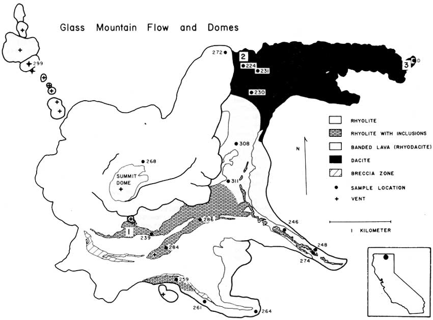
As you can see below in a rotated version of the map, the Glass Mountain dacite-rhyolite flow "consists of three dacitic eastern lobes which grade westward to rhyolite and are overlain by rhyolite lobes" (Donnelly-Nolan et al., 1981, and in Coyner, 2015). Well, maybe not all of that is obvious at first glance, but read on.
 |
| Map showing the silica content of different parts of the Glass Mountain dacite-rhyolite flow (Donnelly-Nolan, unpublished). North is up. |
On the map, the highest silica parts of the flow, the rhyolite, are in orange; the parts of the flow with lowest silica content, the dacite, are in purple; the areas with silica content in between rhyolite and dacite, essentially rhyodacite, are in red. NOTE: Though by many classification schemes the silica content of rhyolite is about 68 or 69% and higher (the USGS appears to be using two different cutoffs), and the silica content of dacite ranges from about 63-68% or 69%; TAS diagrams show dacite compositions as high as 72-75% (depending on what version of TAS one happens to choose; here's one; TAS explained here and here; and a lot more about the classification of igneous rocks—including all kinds of diagrams, references, and a flow chart—can be perused here). Rhyodacite is a term generally used for rock composisitons between rhyolite and dacite (USGS, OSU), rather than a specific field in most classification systems.
The colorful map (I love color!) shows that the lithologic composition of the overall flow, which is thought to have erupted during the course of several or many days or weeks rather than over several months or years, is quite variable. The complexities of magma mixing and eruption to produce this variability are described by Eichelberger (1975, 1981). Basically, it's complicated: first, basalt intrudes a rhyolite magma chamber; then mixing creates rhyodacite and dacite, which float to the top of the chamber in his eruption scenario; eruption, triggered by the mixing, produces dacite, then rhyodacite, then rhyolite.
Below, I decided to see what kind of map I would come up with going mostly by color and topographic expression of the flows (with a lot of help from Julie's map).
 |
| Google Earth image of the Glass Mountain dacite-rhyolite flow. |
 |
| Here, I've delineated the dark areas with purple lines, the light, viscous, and some banded areas with orange lines, and the in between areas with red lines. |
 |
| I've added some colorful fill to facilitate comparison to the geologic map. |
 |
| Here's the rotated map again (and it's skewed). |
Well, that was really a kind of long aside, almost like a post within a post!
Besides hanging around the map and hefting large rocks, the view from the east side of the rhyolite flow (see our location below the post) was good—not great simply because of the low-hanging clouds that hadn't lifted.
 |
| Photo looking south. |
 |
| Photo looking nearly due east. |
Oh, and btw, the Glass Mountain flow erupted about 900 years ago: it has a calibrated radiocarbon age of 890 BP (Donnelly-Nolan et al., 2007).
 |
| With the blocky rocks of the dacite flow lobe in the foreground, we look northeasterly in this photo. That's probably Double Head Mountain just left of center; the north edge of Timber Mountain is on the far right. |
A Few References:
A Web Browser Flow Chart for the Classification of Igneous Rocks - a lot of info (largely from Le Bas and Streckeisen, 1999, and other related sources), and a flow chart
Tephra and Volcaniclastic Rocks - good overall classification scheme, though it doesn't reference any primary sources, and allows agglutinate to occur only in basaltic rocks
Coyner, Alan (ed.), 2015, Geological Society of Nevada 2015 fall field trip guidebook: Geology of the Far Northwestern Great Basin: Quartz Mountain gold deposit, Oregon, and Lava Beds National Monument and Glass Mountain Pumice Deposit, California [for sale here, but not yet listed]: Geological Society of Nevada, Special Publication No. 60, 71 p.
Donnelly-Nolan, J. M., 2010, Geologic map of Medicine Lake Volcano, Northern California: U.S. Geological Survey Scientific Investigations Map 2927, scale 1:50,000, Sheet 1 and Sheet 2, Pamphlet to accompany the map, 48p.
Donnelly-Nolan, J.M., Ciancanelli, E.V., Eichelberger, J.C., Fink, J.H., Heiken, Grant, 1981, Roadlog for field trip to Medicine Lake Highland. in Johnson, D., and Donnelly-Nolan, J., eds., Guides to some volcanic terranes in Washington, Idaho, Oregon, and northern California: U.S. Geological Survey Circular 838, p. 141–149.
Donnelly-Nolan, J. M., Nathenson, M., Champion, D. E., Ramsey, D. W., Lowenstern, J. B. & Ewert, J. W., 2007, Volcano hazards assessment for Medicine Lake Volcano, Northern California: U.S.Geological Survey Scientific Investigations Report, 2007-5174-A, 26 p
Eichelberger, J.C., 1975, Origin of andesite and dacite: Evidence of mixing at Glass Mountain in California and at other circum-Pacific volcanoes: Geological Society America Bulletin 86, v. 10, p 1381-1391.
Eichelberger, J.C., 1981, Mechanism of magma mixing at Glass Mountain, Medicine Lake Highland volcano, California, in Johnson, D., and Donnelly-Nolan, J., eds., Guides to some volcanic terranes in Washington, Idaho, Oregon, and northern California: U.S. Geological Survey Circular 838, p. 183-189.
jpg of lava chemistry figure (Eichelberger, 1981)
Hildreth, Wes, 1981, David Alexander Johnston, 1949-1980, in Johnson, D., and Donnelly-Nolan, J., eds., Guides to some volcanic terranes in Washington, Idaho, Oregon, and northern California: U.S. Geological Survey Circular 838, p. viii-x.
Johnston, D.A., and Donnelly-Nolan, J.M., 1981, Guides to Some Volcanic Terranes in Washington, Idaho, Oregon, and Northern California [pdf version; also here in html]: U.S. Geological Survey Circular 838, 189 p.
4 comments:
I did not realize that another name for pumice is rhyolite obsidian. Good to know! Also, 890 years ago for the Glass Mtn. flow is not that long ago.
Glassy, dense obsidian should be called obsidian or volcanic glass (or can be named by its composition, e.g. rhyodacite obsidian).
Pumice is one type of volcanic glass, one that is very light weight and which contains numerous vesicles from gas bubbles contained in the lava (in the case of the rocks in the photo that I was describing, a true rhyolite). Pumice is often (maybe usually) a type of air-fall deposit. This air-fall type (a type of tephra), which I don't personally prefer to call "pumice" but am happier calling pumiceous lava or vesiculated obsidian, is part of a rhyolite flow. I don't know if the rhyodacite or dacite parts of the flow also contain a vesiculated variety. My calling it "vesiculated, rhyolite obsidian" maybe should have just said "vesiculated obsidian, in this case rhyolite (which can also be called pumice...yada yada).
My first post contains three links to descriptions of this type of rock. I guess I should have included those links here. Possibly I'll revise this slightly.
From the first post: "Vesiculated obsidian (pumice or "puffed obsidian", AKA pumiceous lava flow rock, part of the rhyolite flow rather than tephra)..."
So in other words, one type of rhyolitic obsidian or rhyolitic volcanic glass -- the vesiculated type -- can be called pumice. Typical black, dense, non-vesicular or weakly vesicular obsidian would not be called pumice, and not all pumice or obsidian is necessarily a true rhyolite. For example, the climactic eruption of Mt. Mazama (now Crater Lake) produced widespread pumice and ash fall of mostly rhyodacite composition (Bacon+Druitt, 1988).
Besides the more scientific explanation of pumice, volcanic glass, obsidian, tuff, etc. we used a rather simple short-cut when teaching 2nd semester students who usually don't yet have enough experience with the variety of light volcanic rocks.
If a highly porous volcanic rock swims on water, then it's pumice. If it sinks, it's not. You can then add rhyolitic or dacitic or whater-pumice. But it has to swim. This is not 100% right but the density of practially all pumices is around 1, usually lower.
That's right, usually part of the basic definition is that it "often" floats on water. And descriptions often sa.y frothy, porous, very low density.
I'm not used to thinking of it as part of a flow, but apparently it does often form at the top of a flow.
The f.t. leader and Julie Donnelly-Nolan both referred to the rock at this spot as pumice, and it has been mined as pumice, I think. I'm not sure I collected a good specimen to test it on water -- I might have one frothy sample -- I should try it!
Post a Comment