Showing posts sorted by relevance for query great basin national park. Sort by date Show all posts

Saturday, August 27, 2011

Alpenglow and Tentglow

On the way over to Great Basin National Park last week, I grabbed this quick photo of the alpenglow hitting the west side of Wheeler Peak (13,063 feet ASL), partly because the lower line of the pinkish band was hitting the mountain at just about tree line. The pinkish band is sometimes known as the Belt of Venus or antitwilight arch, at least when it is seen in the sky, and the dark purplish blue area below the alpenglow is the Earth's shadow on the mountain. It is sometimes called the dark segment, at least when seen in sky.

If you happen to be standing on a mountain when this pinkish phenomenon is visible to those to the west of you, you will be standing in the pinkish, dying light of the sun, just before it goes below your western horizon (presuming you aren't in Alaska or somewhere very far north or very far south, where the sun doesn't always set in the west, but can set in the north or south, or not set at all). As the pinkish, last light of the sun leaves you on your mountain perch, the terminator will come upon you, you'll be in the twilight zone, and then you will pass into the night (all while standing still).
In this grainier enlargement of the same photo, you can see that the pinkish alpenglow isn't exactly congruent with tree line in all places.
We drove on, to find and set up camp in the dark, at about 9800 feet on the other side of that same mountain.

Recent Great Basin N.P. Blogospherics:
A Park without it's Namesake at Geotripper
We Head Underground in the Great Basin at Geotripper
Great Basin National Park at Nature's Blog
My Backyard - Great Basin NP at WATCH FOR ROCKS

Wednesday, January 2, 2013

Great Basin Dotmap

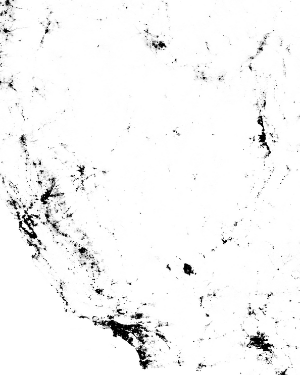
I thought I'd have a little more fun with the Census Dotmap I posted about a couple days ago, by conjuring up a shot of the Great Basin:

Screenshot from Census dotmap by @ewedistrict and @kieran.
The dotmap highlights the lack of people living inside the Great Basin. Instead, the bulk of the population is outside, or is located around the edges (Salt Lake City, Las Vegas, Reno). The northern boundary of the Great Basin is vague in the dotmap view, but the Snake River Plain to the north of the Great Basin's northern edge is easily identified. The northwest and southwest boundaries, near Goose Lake and Death Valley respectively, are also somewhat vague on the dotmap.

Two more views of the Great Basin:
Greatbasinmap by Kmusser [CC-BY-SA-3.0], via Wikimedia Commons.
Great Basin in magenta, from National Park Service.

Thursday, July 10, 2008

Rock Glacier: The First View

rock glacier view sign viewAs you leave the Bristlecone pine grove, you hike up a lumpy, rocky glacial moraine and fairly shortly come in view of the rock glacier sitting in the cirque on the north side of Wheeler Peak. All or most online references I could find to the active glacier on Wheeler Peak cited the NPS website. As the sign above from the park shows, there is a glacier and a rock glacier on Wheeler Peak. This link, page 10, states that the rock glacier was active until 1955, although it doesn't go into any details. I'll get into the convoluted history of the glacier and rock glacier in another post. This USGS Professional Paper, 2002, page 9, lists a glacier on Wheeler Peak, one that has an area of 0.2 square kilometers. The authors don't say whether they are referring to the glacier, the rock glacier, or both. MOH and I did not make it all the way up to the glacier, which is a small cirque glacier with hanging glacier above it, or possibly just a cirque glacier (see these types of glaciers). At the time of field work done by Osborne and Bevis (2001) - over a period of 10 years in the 1990's - the glacier was definitely active, being perennial, deforming under it's own weight, and showing a bergschrund. As for the rock glacier itself, there are numerous definitions and descriptions of rock glaciers, some of which include rock glaciers that don't have any ice anymore - either interstitial to the rocks making up the rock glacier (ice-cemented) or below the rocks of the rock glacier (ice-cored).

rock glacier closeup A closer view of the rock glacier shows that the upper portion has a steep face that rises above the lower portion (behind the talus slope seen on the right side of the photo). The rock glacier has snow or ice fields on both sides of it, and snow, ice, and the small glacier behind it at the base of the cirque headwall and upward into the larger talus-ice chute (seen somewhat in the above photo). The small glacier feeds into or grades into the rock glacier at its base.

As I said, I'll get into a few more details in a later post, and will have considerably more references.

References: 

Krimmel, R.M., 2002, Glaciers of the western United States, with a section on Glacier retreat in Glacier National Park, Montana by Key, C.H., Fagre, D.B., and Menicke, R.K., Glaciers of the conterminous United States (J-2) in in Williams, R.S., Jr., and Ferrigno, J.G., eds., Satellite image atlas of glaciers of the world: U.S. Geological Survey Professional Paper 1386-J (Glaciers of North America), 405 p., ISBN 0-067-98290-X.

Osborn, G., 1990. The Wheeler Peak cirque and glacier/rock glacier. Unpublished report prepared for the Great Basin Natural History Association. University of Calgary Dept. of Geology and Geophysics. Osborn, G. and Bevis, K., 2001, Glaciation in the Great Basin of the Western United States: Quaternary Science Reviews 20, 1377-1410.


Wheeler Peak is inside Great Basin National Park

Monday, December 27, 2010

Like caterpillars, crawling or marching...

...northward out of or toward Mexico.

On Christmas Day, I went hunting for the source of the widely quoted description of the Basin and Range, starting with my easy-to-find reference in Bill Fiero's Geology of the Great Basin. He said that a long time ago a geologist had compared the mountain ranges of the Basin and Range to "dark fuzzy caterpillars crawling northward" [his words]. He didn't reference the geologist, so I got to wondering and went online. Well, I was already online, but I went farther, into that great Google machine, starting with "basin and range caterpillars," which got me the Wikipedia Basin and Range page and The Basin and Range Province (Coulter, 2005). Both pages state that it was Clarence Dutton who made the analogy, quoting him as saying "army of caterpillars marching toward Mexico" and "an army of caterpillars crawling northward out of Mexico," respectively. You'll immediately notice the double discord: marching v. crawling and toward v. out of.

I was inclined to go with the second quote, because it partly agreed with what Fiero had said, and because at least Coulter (2005) had given a reference, namely to King (1977). Going back to Google with basin and range "army of caterpillars" dutton, I found another reference to "an army of caterpillars crawling northward out of Mexico" by Mac and others (1998), who again cited King (1977), with Dutton being the quotee; and I also found this article (Jensen and Platts, 1990), which quotes Dutton (1880) as saying "army of caterpillars marching to Mexico," reinforcing the quote confusion, but providing the alleged source: Dutton (1880).

So, hence to Dutton's 1880 tome, Geology of the high plateaus of Utah, which is searchable online by various methods, including visual scanning. The quote, if present in that volume in any form, would have to be hidden on a map included in the Atlas (which I also viewed and eliminated), or in the footnotes, many of which I scanned. Searching for "caterpillars" or "Mexico" does not yield the quote; searching for all occurrences of "north" does not yield the quote. I didn't try all occurrences of "out of" or "toward," but did scan all seemingly relevant chapters and sections more than once without results. The problem with search methods other than reading or visual scanning, is that the original is old, so some words don't search properly or have been changed by the various methods of acquisition (e.g., digital scanning) to other words or nonsense words. Also, a word like northward can be broken at the end of a line into "north-" and followed in the next line by "ward." The quote might still be in there somewhere, but I doubt it.

Then, tyring to get some help via Twitter, I was led by @rschott to the above picture, which is from Dante's View at Death Valley National Park. The sign quotes Dutton (1880) as saying, "...like an army of caterpillars crawling toward Mexico...." Darn, there for a minute I thought the caterpillars crawled when going north, and marched when going south!

Ron Schott also found an old reference to the quote, wherein Keyes (1920) said that Dutton "likens [the ranges] on the map to an army of caterpillars crawling northward out of Old Mexico." This is the oldest reference (so far), perhaps giving credence to the northward crawling aspect of the alleged Basin and Range quote. Additionally, at least one reference (Udall, 1998) has Dutton "quipping," suggesting that Dutton might have been speaking at a meeting rather than writing a report.

Another tidbit in this intensive reference hunt: I found one endnote (in Goin and Starrs, 2005) that states:
"army of caterpillars" is without a doubt Clarence Dutton's comment, but exact attribution is impossible – although everyone knows he wrote or said it, chapter and verse are undocumented in our experience, but it is quoted by John McPhee in Basin and Range (1981).
I couldn't find the quote or a reference to Dutton in Basin and Range.
Basins and ranges in central Nevada

And then things got interesting.

This search led to a more detailed quote from Dutton: "composed of many short, abrupt ranges looking upon the map like an army of caterpillars crawling northward. At length the army divides into two columns...." I couldn't, however, search farther in that book (Anderson, 1977), or find where Dutton said that. Later, on Boxing Day, I used this search confining the timing to 1879 to 1921, and found this long reference to Dutton's description of the desert mountains or arid ranges of the west (Keyes, 1909), though it isn't explicitly a quote:
Upon the map Dutton has likened them to an army of caterpillars crawling northward out of Mexico, dividing as it enters the United States, the main body turning westward and then northward again until it passes into the British possessions.
I was pretty sure at this point that we had narrowed it down to, more or less, "an army of caterpillars crawling northward out of Mexico," but I still couldn't find the reference!

I then went a little farther, using this search to reveal even more of the Dutton quote, still with no viewable reference (Anderson, 1977):
"...composed of many short abrupt ranges looking upon the map like an army of caterpillars crawling northward. At length the army divides into two columns, one marching northwest, the other north-north east."
Anderson (1977) then goes on to say, "Hence the Great Basin's ranges, and the Rockies...," implying that the quote refers to the entire west, not just the Basin and Range.

By this time, I was ready to finish up this blog post and move on, so I grabbed another view of the west from Google Earth...
And then, late in the afternoon, another link came in from Twitter, this time from @microecos, who blogs here. It's the full and entire quote, with the source! Dutton (1886) says:
The great belt of Cordilleras coming up through Mexico and crossing into United States territory is depicted as being composed of many short, abrupt ranges or ridges, looking upon the map like an army of caterpillars crawling northward. At length, about 150 miles north of the Mexican boundary, this army divides into two columns, one marching northwest, the other north-northeast The former branch becomes the system of mountain ridges spread over the southern and western portions of Arizona, the whole of Nevada and the western portion of Utah and extending into Oregon and Idaho.
What he goes on to say from there, makes it clear that the western army going to the northwest (to begin with) is the Basin and Range of Arizona, Nevada, Utah, Oregon, and Idaho, and the eastern army, going to the north-northeast (to begin with) is the Rocky Mountains.

Check it out for yourself, right here!

How many times has Dutton been misquoted? Not sure, but I'd say tens of times—or more! I own at least two such misquotes, myself (the caterpillars crawling or marching to or toward Mexico rather than crawling northward). Surprisingly, the misquoting began as early as 1915!

Some References:
Anderson, R.S., 1977, A biography of Clarence Edward Dutton (1841-1912), nineteenth century geologist and geographer: Stanford University, 252 pp.

Coulter, Poppy, 2005, The Basin and Range Province: Volcanoes of the Eastern Sierra Nevada,: Geology and Natural Heritage of the Long Valley Caldera, at Indiana University Geological Sciences (a field course website).

Dutton, C.E., 1880, Geology of the high plateaus of Utah: U.S. Geographical and Geological Survey of the Rocky Mountain Region, vol. 32, 307 pp, with Atlas.

Review of Dutton's 1880 monograph at Magma Cum Laude

Dutton, C.E., 1886, Mount Taylor and the Zuni Plateau, p. 105-198 in Volume III of Report of the Secretary of the Interior; being part of the Message and Documents Communicated to the Two Houses of Congress at the Beginning of the First Session of the Forty Ninth Congress in Five Volumes: Washington, Government Printing Office.

Fiero, Bill, 1986, Geology of the Great Basin: University of Nevada Press, 198 pp.

Goin, Peter, and Starrs, P.F., 2005, Black Rock, Volume 2004: University of Nevada Press, 273 pp.

Jensen, S.E., and Platts, W.S., 1990, Restoration of degraded riverine/riparian habitat in the Great Basin and Snake River Regions, p. 367-404 in J.A. Kusler and M.E. Kentula (eds.) Wetland Creation and Restoration: The Status of the Science. Island Press, Washington, D.C. 591 pp.

Keyes, C.R., 1909, Lineaments of the desert: Popular Science Monthly, v. 74, p. 19-30.

Keyes, Charles, 1920, Paleozoic Diastrophics of the Northern Mexican Tableland: The Journal of Geology, vol. 28, no. 1, p. 75-83.

King, P.B., 1977, The Evolution of North America: Princeton University Press, 216 pp.

Mac, M. J., Opler, P. A., Puckett Haecker, C. E., and Doran, P. D., 1998, Great Basin—Mojave Desert Region in Status and trends of the nation’s biological resources Vol. 2: U.S. Department of the Interior, U.S. Geological Survey, Reston, VA, p. 437-964.

McPhee, John, 1981, Basin and Range: Farrar, Straus, Giroux, 215 pp.

Rice, W.N., Adams, F.D., Coleman, A.P., Walcott, C.D., Lindgren, Waldemar, Ransome, F.L., and Matthew, W.D., 1915, Problems of American geology: a series of lectures dealing with some of the problems of the Canadian shield and of the Cordilleras: Yale University Press, 505 pp.

Udall, S.L., 1998, The myths of August: a personal exploration of our tragic Cold War affair with the atom: Rutgers University Press, 412 pp.

A Few Google Book Searches:
clarence dutton caterpillars
dutton caterpillars crawling (1879-1921)
dutton caterpillars crawling northward divides northeast
abrupt ranges looking upon the map like an army of caterpillars

Sunday, December 14, 2008

100 Things Meme - Geology Style

Geotripper started this geological 100 things meme - anyone, including non-geologists can play - and check out Highly Allochthonous for the current score. Bold the ones you've done and add any notes, and put drop your link here.

1. See an erupting volcano [Pu'u O'o in Hawaii, 1987]
2. See a glacier [several, several times, in Alaska]
3. See an active geyser such as those in Yellowstone, New Zealand or the type locality of Iceland [Yellowstone]
4. Visit the Cretaceous/Tertiary (KT) Boundary. Possible locations include Gubbio, Italy, Stevns Klint, Denmark, the Red Deer River Valley near Drumheller, Alberta.
5. Observe (from a safe distance) a river whose discharge is above bankful stage [a small wash or creek near Reno, Nevada, in flash flood]
6. Explore a limestone cave. Try Carlsbad Caverns in New Mexico, Lehman Caves in Great Basin National Park, or the caves of Kentucky or TAG (Tennessee, Alabama, and Georgia) [I've mostly seen caves on tours - Lehman, Nevada, Carlsbad, N.M., and Luray in Virginia - I've also been in a cave now under water in the New Melones Dam area, California]
7. Tour an open pit mine, such as those in Butte, Montana, Bingham Canyon, Utah, Summitville, Colorado, Globe or Morenci, Arizona, or Chuquicamata, Chile. [Several, including many of the big Carlin Trend mines in Nevada, Pinson, Nevada, a copper mine in Arizona, and the Mesquite and Picacho mines in California]
8. Explore a subsurface mine. [A couple active U.G. mines, including the Gooseberry mine in Nevada, and I've mapped several old, inactive mines]
9. See an ophiolite, such as the ophiolite complex in Oman or the Troodos complex on the Island Cyprus (if on a budget, try the Coast Ranges or Klamath Mountains of California). [California]
10. An anorthosite complex, such as those in Labrador, the Adirondacks, and Niger (there's some anorthosite in southern California too).
11. A slot canyon. Many of these amazing canyons are less than 3 feet wide and over 100 feet deep. They reside on the Colorado Plateau. Among the best are Antelope Canyon, Brimstone Canyon, Spooky Gulch and the Round Valley Draw.
12. Varves, whether you see the type section in Sweden or examples elsewhere. [Pyramid Lake, Nevada and Summer Lake, Oregon - I think some of the Pleistocene lake deposits qualify as varves.]
13. An exfoliation dome, such as those in the Sierra Nevada. [Half Dome, others]
14. A layered igneous intrusion, such as the Stillwater complex in Montana or the Skaergaard Complex in Eastern Greenland. [only in labs]
15. Coastlines along the leading and trailing edge of a tectonic plate (check out The Dynamic Earth - The Story of Plate Tectonics - an excellent website). [the west coast of North America, especially Oregon and northern California, also Alaska; the east coast of the U.S., especially Virginia and Maine]
16. A ginkgo tree, which is the lone survivor of an ancient group of softwoods that covered much of the Northern Hemisphere in the Mesozoic.
17. Living and fossilized stromatolites (Glacier National Park is a great place to see fossil stromatolites, while Shark Bay in Australia is the place to see living ones). [fossilized ones, only]
18. A field of glacial erratics. [British Columbia]
19. A caldera [Crater Lake, Long Valley, Yellowstone, many old ones]
20. A sand dune more than 200 feet high [Sand Mountain, Nevada, Imperial Sand Dunes, southern California]
21. A fjord. [Turnagain Arm and Knick Arm, Alaska]
22. A recently formed fault scarp. [The 1954 Fairview Peak fault scarp in Nevada]
23. A megabreccia. [Alaska, Nevada]
24. An actively accreting river delta.
25. A natural bridge. [Natural Bridge, Virginia]
26. A large sinkhole. [Somewhere near Austin, Texas]
27. A glacial outwash plain. [Alaska]
28. A sea stack. [Oregon coast]
29. A house-sized glacial erratic.
30. An underground lake or river.
31. The continental divide. [Loveland Pass]
32. Fluorescent and phosphorescent minerals. [Smithsonian Museum of Natural History - and fluorescent ones under black light in core, in skarn, in labs]
33. Petrified trees. [Petrified Forest National Park, Arizona]
34. Lava tubes. [Subway Cave north of Lassen Peak, California, Hawaii including one in action, and northern California]
35. The Grand Canyon. All the way down. And back. [Rafted out]
36. Meteor Crater, Arizona, also known as the Barringer Crater, to see an impact crater on a scale that is comprehensible. [I don't remember this very well, back in 1973]
37. The Great Barrier Reef, northeastern Australia, to see the largest coral reef in the world.
38. The Bay of Fundy, New Brunswick and Nova Scotia, Canada, to see the highest tides in the world (up to 16m).
39. The Waterpocket Fold, Utah, to see well exposed folds on a massive scale. [A couple times, most recently in 1993]
40. The Banded Iron Formation, Michigan, to better appreciate the air you breathe. [Marquette Iron Range, 1975]
41. The Snows of Kilimanjaro, Tanzania.
42. Lake Baikal, Siberia, to see the deepest lake in the world (1,620 m) with 20 percent of the Earth's fresh water.
43. Ayers Rock (known now by the Aboriginal name of Uluru), Australia. This inselberg of nearly vertical Precambrian strata is about 2.5 kilometers long and more than 350 meters high
44. Devil's Tower, northeastern Wyoming, to see a classic example of columnar jointing.
45. The Alps.
46. Telescope Peak, in Death Valley National Park. From this spectacular summit you can look down onto the floor of Death Valley - 11,330 feet below. [I've seen the peak from Badwater and from Panamint Valley, but not from the top looking down]
47. The Li River, China, to see the fantastic tower karst that appears in much Chinese art
48. The Dalmation Coast of Croatia, to see the original Karst.
49. The Gorge of Bhagirathi, one of the sacred headwaters of the Ganges, in the Indian Himalayas, where the river flows from an ice tunnel beneath the Gangatori Glacier into a deep gorge.
50. The Goosenecks of the San Juan River, Utah, an impressive series of entrenched meanders.
51. Shiprock, New Mexico, to see a large volcanic neck.
52. Land's End, Cornwall, Great Britain, for fractured granites that have feldspar crystals bigger than your fist.
53. Tierra del Fuego, Chile and Argentina, to see the Straights of Magellan and the southernmost tip of South America.
54. Mount St. Helens, Washington, to see the results of recent explosive volcanism.
55. The Giant's Causeway and the Antrim Plateau, Northern Ireland, to see polygonally fractured basaltic flows.
56. The Great Rift Valley in Africa.
57. The Matterhorn, along the Swiss/Italian border, to see the classic "horn".
58. The Carolina Bays, along the Carolinian and Georgian coastal plain
59. The Mima Mounds near Olympia, Washington. [I've seen these in several places, including northern Oregon]
60. Siccar Point, Berwickshire, Scotland, where James Hutton (the "father" of modern geology) observed the classic unconformity.
61. The moving rocks of Racetrack Playa in Death Valley.
62. Yosemite Valley. [Practically grew up there]
63. Landscape Arch (or Delicate Arch) in Utah.
64. The Burgess Shale in British Columbia.
65. The Channeled Scablands of central Washington.
66. Bryce Canyon.
67. Grand Prismatic Spring at Yellowstone.
68. Monument Valley.
69. The San Andreas fault.
70. The dinosaur footprints in La Rioja, Spain.
71. The volcanic landscapes of the Canary Islands.
72. The Pyrenees Mountains.
73. The Lime Caves at Karamea on the West Coast of New Zealand.
74. Denali (an orogeny in progress).
75. A catastrophic mass wasting event. [Blackhawk slide in southern, California - huge; and the Toutle River flooding and mudflow event following the 1980 Mt. St. Helens eruption]
76. The giant crossbeds visible at Zion National Park.
77. The black sand beaches in Hawaii (or the green sand-olivine beaches). [Maybe just the black sand beaches]
78. Barton Springs in Texas
79. Hells Canyon in Idaho.
80. The Black Canyon of the Gunnison in Colorado.
81. The Tunguska Impact site in Siberia.
82. Feel an earthquake with a magnitude greater than 5.0. [Not sure]
83. Find dinosaur footprints in situ.
84. Find a trilobite (or a dinosaur bone or any other fossil).
85. Find gold, however small the flake. [Lots]
86. Find a meteorite fragment.
87. Experience a volcanic ashfall.
88. Experience a sandstorm. [Mojave Desert, California]
89. See a tsunami.
90. Witness a total solar eclipse. [1970]
91. Witness a tornado firsthand. [Only a very small one]
92. Witness a meteor storm, a term used to describe a particularly intense (1000+ per minute) meteor shower.
93. View Saturn and its moons through a respectable telescope.
94. See the Aurora borealis, otherwise known as the northern lights. [As far north as Anchorage, as far south as Reno, Nevada]
95. View a great naked-eye comet, an opportunity which occurs only a few times per century. [First in the late 1950's or early 1960's - not sure which one]
96. See a lunar eclipse.
97. View a distant galaxy through a large telescope.
98. Experience a hurricane. [Only the spent portions of these]
99. See noctilucent clouds
100. See the green flash.

That's 55, counting Telescope Peak from the bottom up, black sands for sure but maybe not green, and not hiking out of the Grand Canyon just all the way down. That's just about one per year. I probably won't make all of them, and there are a few I'd rather not experience except from a safe distance.

UPDATE: I just added #75, after reading Geotripper's One Hundred; I've seen (and mapped part of) the Blackhawk slide in southern California, and was at the Toutle River while it was still in flood after the 1980 Mt. St. Helens eruption. That would make one per year.

Sunday, July 20, 2008

Rock Glacier: History and Links

As part of this ongoing rock glacier series, I thought I'd get into the history of the rock glacier a little bit, as it cannot be found anywhere online in any detail. Most of this information comes from Osborne and Bevis, 2001 (OB2001). I'll have some more photos later, including an aerial view from the peak!

According to OB2001, it was W. Eimbeck who first wrote about the glacier in 1883, with his writing then being reported on by I. C. Russell (1885). Osborn and Bevis go on to assert that W. F. Heald then rediscovered the glacier in 1955 (reported on by Heald, 1956), although Heald said that he didn't rediscover it, he discovered it. His discovery or re-discovery, depending on which account is accurate, was described in Desert Magazine in August, 1956, page 4, as follows:

Interest in [the Wheeler Peak] area as a potential national park developed in recent months after Weldon Heald of Tucson and Albert Marshall of Three Rivers, California, made the ascent of 13,061-foot [13,063] Wheeler Peak and ascertained that a glacier on the east slope of the mountain, first reported by the U. S.Geological Survey in 1883, was still active.... Following his ascent of Wheeler Peak, Weldon Heald wrote: "We arrived at the summit at noon. The view from the wedge-shaped crest of the Peak is utterly magnificent. From our perch on the topmost rocks, 13,061 feet above sea level, we looked out over a 360-degree panorama embracing thousands of square miles of deserts, valleys, hills and mountains in eastern Nevada and western Utah. Then we worked our way down the east slope to the edge of a 2000-foot sheer cliff. There in the depths of a cirque below we saw the ice field described by the Geological Survey in 1888. The surface was broken by what appeared to be a bergshrund, a secondary bergshrund [sic], and below these five parallel crevasses one above another. Every sign indicated that the ice was in motion and this was probably a true glacier."
And this is what Weldon F. Heald had to say about that, in the October issue of Desert Magazine, pages 31-32:

Received my August Desert today and feel you did a mighty fine job of presenting the subject of the proposed park or monument in the Wheeler Peak area—and Norton Allen made a fine map from my rough one. I think this will help the cause along greatly. There's one thing though that seems to be misunderstood. The glacier was not "re-discovered" in 1955, it was discovered. Although Eimbeck saw ice at the head of the cirque in 1883, he neither reported it as an active glacier nor suspected it was one. The reason is rather easy to explain. He did not see into the bottom of the cirque, where the glacier lies, and it is probable he would not have realized that the ice was active because it was covered with too much snow.

The ice Eimbeck saw and reported, and pictured in his engraving, is the neve tongue on the cliffs above the glacier. Many must have seen this upper ice but no one suspected that an active glacier lay in the hidden cirque beneath. We wouldn't have either except that I especially chose September of one of the driest years on record, when all the usual snow had melted away and left the naked ice beneath.

Old-timers tell me that a glacier has been supposed to exist on Wheeler Peak for years. However, it apparently was not this one but an ice field in Wheeler Peak's south cirque. We saw this too, but it is now greatly shrunken and definitely not active. So, inasmuch as no one knew or suspected that a glacier existed in Wheeler Peak's north cirque until 1955, I feel that it was definitely discovered then, and that we discovered it, not Eimbeck. However, it was his tip that made me scout for the ice — but I never had any idea I'd find an active glacier.
Others who wrote about the glacier after 1956 - as cited by OB2001 - include Lawrence (1958), Kramer (1962), Currey (1969), Waite (1974), and Osborn (1990). Some confusion apparently existed as to what to call the glacier and the rock glacier, with the glacier being referred to as follows (again from OB2001):
  • 'body of ice...that approaches the condition of a glacier'
  • 'glacieret'
  • 'ice mass'
  • 'active glacier'
  • 'ice field'
The rock glacier has been called by the following epithets, according to them:
  • 'moraine tongue'
  • 'mound of unstable moraine'
  • 'rock deposit'
  • 'rock glacier'

Various claims have been tossed around as to the active v. inactive status of both the glacier and the rock glacier, with the rock glacier sometimes being referred to as active and the glacier being called inactive to non-existent (the latter notably in an argument against the establishment of a National Monument or Park at Wheeler Peak - as per information from OB2001). It's the glacier that is (or has very recently been) active; it's the rock glacier that's inactive.

That most definitive paper I could find (OB2001) states that the glacier was active at the time of study, and that the rock glacier was not active (the study took place during the 1990's). They state that the "glacier grades into an ice-cored rock glacier downstream" - that would be down hill or down the ice gradient (or water gradient, if the thing is melting). And for various reasons - including topography, shape, vegetation, and presence or lack of certain tephra layers including ash from Mono Craters and Mt. Mazama - they determined that the upper portion of the rock glacier had an origin in the Little Ice Age (sometime from A.D. 1300 to A.D. 1850), and that the lower, lumpy part of the rock glacier had an origin sometime prior to A.D. 1200. Osborn and Bevis (2001) say "...shards of Mono Craters origin incorporated into the matrix of the lower rock glacier indicates a pre-1200 AD origin of that segment." This seems a bit confusing to me, because elsewhere in the paper, when refering to tephra from Mono Craters, they refer to the Mono Craters tephra that is dated at 1200 B.P. (not one from 1200 A.D.). So, I'm not sure what this means exactly, or maybe it has something to do with whether or not the C-14 dates are calibrated. There are numerous tephra layers from Mono Craters, with ages of 560 ± 20, 1200 ± 40, 2060 ± 75, 3730 ± 60, 7270 ± 70, 8235 ± 105, and 9710 ± 80 B.P. (dates from this site; calibrated or not?).

Because the Mazama ash doesn't occur anywhere in the southern Snake Range, according to Osborn and Bevis (2001), I presume that its absence in or on the rock glacier can't be used to determine whether the rock glacier is older or younger than the 6845 ± 50 B.P. carbon-14 date on the Mazama ash, or about 7,700 calendar years ago (Bacon, 1983). According to a map showing the distribution of the Mazama ash, by Sarna-Wojcicki, Champion, and Davis (1983) [per OB2001], the southern Snake Range may be right near the edge of the fallout lobe of the Mazama ash. I found two maps online; one is from Sarna-Wojckicki and Davis (1991), [published posthumously by J. O. Davis]; the other one has an undefined origin, but might be from S-W, C, and D (1983). The latter map is more detailed.

The bottom line is: active glacier (unless it has become inactive during the last decade) and inactive, ice-cored rock glacier.

Rock Glacier Definitions:
USGS Glossary of Glacier Terminology
USGS Rock Glaciers
J. Geophysical Research

References:
Bacon, C. R., 1983, Eruptive History of Mount Mazama and Crater Lake Caldera, Cascade Range, U.S.A.: Journal of Volcanology and Geothermal Research, v.18, p.57-115.

Currey, D.R., 1969. Neoglaciation in the mountains of the southwestern United States. Unpublished Ph.D. Thesis, University of Kansas.

Heald, W. F., 1956, An Active Glacier in Nevada: American Alpine Journal, 10 (1), 164-167.

Kramer, F.L., 1962. Rivers of stone. Pacific Discovery 15 (5), 11-15.

Krimmel, R.M., 2002, Glaciers of the western United States, with a section on Glacier retreat in Glacier National Park, Montana by Key, C.H., Fagre, D.B., and Menicke, R.K., Glaciers of the conterminous United States (J-2) in in Williams, R.S., Jr., and Ferrigno, J.G., eds., Satellite image atlas of glaciers of the world: U.S. Geological Survey Professional Paper 1386-J (Glaciers of North America), 405 p., ISBN 0-067-98290-X.

Lawrence, E., 1958. The Wheeler Glacieret of the Wheeler Peak area, White Pine County, Nevada. Unpublished manuscript, Nevada Bureau of Mines, Reno.

Meier, M.F., 1961, Distribution and variations of glaciers in the United States exclusive of Alaska, in General Assembly of Helsinki, 1960: International Association of Scientific Hydrology Publication No. 54, p. 420–429.

Osborn, G., 1990. The Wheeler Peak cirque and glacier/rock glacier. Unpublished report prepared for the Great Basin Natural History Association. University of Calgary Dept. of Geology and Geophysics.

Osborn, G. and Bevis, K., 2001, Glaciation in the Great Basin of the Western United States: : Quaternary Science Reviews 20, 1377-1410.

Russell, I.C., 1885. Geological history of Lake Lahontan, a Quaternary lake of northwestern Nevada. U. S. Geological Survey Monograph 11, 288.

Sarna-Wojcicki, A. M., and Davis, J. O., 1991, Quaternary tephrocrhonology, in Morrison, R. B. (ed.) Quaternary Non-Glacial Geology: Conterminous United States. Geological Society of America, Decade of North American Geology, Vol. K-2, Boulder, Colorado, 93-116.

Sarna-Wojcicki, A. M., Champion, D. E, and Davis, J. O., 1983. Holocene volcanism in the conterminous United States and the role of silicic volcanic ash layers in correlation of latest-Pleistocene and Holocene deposits. In: Wright Jr., H. (Ed.), Late Quaternary Environments of the United States 2. University of Minnesota Press, Mineapolis, pp. 52-77.

Waite, R., 1974. The proposed Great Basin National Park: A geographical interpretation of the southern Snake Range, Nevada. Unpublished Ph.D. Thesis, University of California at Los Angeles Geography Dept.

Thursday, July 16, 2009

The Trail to 11,600 Feet

snow The trail to Wheeler Peak, as it goes upward from 10,800 feet, gets into a rocky and variably tree-covered area, with intermixed Englemann spruce and limber pine that get smaller and smaller until they disappear entirely. In this area, we walked and slid over a few snow patches - snow patches that were almost completely gone one week later.
cones Cones amid rocks and twigs.
butterfly A comma butterfly poses for me on a piece of quartzite.
water1 In the last little bit of trees, the trail enters a long patch of running water - an ephemeral stream that disappears into the ground right in front of us. We call this entire stretch of trail "the waterfalls."
water2 Running water below the last stand of trees.
waterfall1 Steps built into the trail become mini-waterfalls.
waterfall2 The waterfall section continues upward, around the corner. It's long enough that it can't fit into any one or two photos from any angle.
water3 And being as how we live in the semi-arid to arid Great Basin, we are fascinated with this exhuberant display of waterflow. I take about a million and a half pictures.
water4 We follow the wet, running trail upward, until the stream turns off into the uppermost bushes and trees.
spring1 Aha! Here we find the beginning of that long stream: a spring below patches of melting snow.
spring2 We stand and stare at this phenomenon for some time, catching our breath in the thin air of this 11,100-foot elevation. One week later, all the running water at this spot was gone.

We've now gone less than half a mile and climbed about 300 feet in about a half an hour.
view From the trail just above the spring, just above the last trees, the view to the northwest and north shows a few clouds. That's Bald Mountain on the right, with Spring Valley and the Schell Creek Range in the distance.
flowers The trail continues upwards, as trails sometimes do, and by 1:30 pm we come into large, green clumps with blooming, yellow flowers and low-growing mats of various kinds. Flower clumps and mats have been common since leaving the highest patch of trees; they seem to grow on us as we move ever upwards.
flowers These buttercup-like flowers are possibly Geum rossii, an alpine plant that grows to at least 12,500 feet in the Great Basin.
flowers Other flowers include the bluish purple Polemonium viscosum - sometimes called sticky or skunky polemonium - and mats of some kind of alpine phlox. The polemonium often makes its presence known before you see it: while walking, you will catch the distinct scent of skunk, the way we did last year on our hike to the rock glacier. If you look around, you will then find these bluish purples flowers.
trail The trail goes ever upward and generally southward towards the peak.
SnakeR Finally, at about 1:45 we reach a point where we have a fairly good view of Mount Moriah and other peaks in the northern Snake Range.
peak The trail is now at about 11,600 feet, and has come to a snow bank. The trail goes into the snow, but we bypass to the right in large, non-trail rocks. We now have a view of what we call "the shoulder," that flat area in the sun, beyond the shaded foreground.

Why is the foreground in shadow? Clouds have been gathering, but so far they haven't looked very threatening.

Wheeler Peak is inside Great Basin National Park

Friday, December 18, 2009

My Year of Traveling Meme

This traveling meme was started by Alice at Sciencewomen, passed to Magma Cum Laude, then to NOVA Geoblog, and on to Geotripper Part 1 and Part 2, and then on to Geology Happens.

January: The famous (or infamous?) International Hotel in Austin, Nevada. This is currently the last recorded visit to this establishment. The beer is okay.
I don't recommend the food.UPDATE 17Jan10: The food on Christmas day was excellent!
February: Great Basin National Park and environs twice (and at least one trip through central Nevada). snow
March: Alaska, for the Iditarod and beers (and more than two trips through central Nevada). turnagain
April: Middlegate Station, Nevada - a good place to eat, has above average beer, and you can have wi-fi in your room. 50 The Carlin Canyon Unconformity (or fault, depending on who you talk to) - and at least two trips through central Nevada.
May: Titus Canyon - the largest breccia fragments are truck sized.breccia Death Valley. The Mojave Desert - granite at Teutonia Peak, part of Cima Dome. teutonia Some mines and properties in western Nevada as part of the GSN spring field trip (and two or three trips across central Nevada, depending on how you define "central."). shack
June: Wheeler Peak in springtime (would you believe late winter?).
July: Back to Wheeler Peak, more than once, where it was looking like spring. wheeler San Francisco, where I didn't get pictures of any famous bridges but did have some good beer. (Also in July, at least two trips through central Nevada.)
August: I made one short trip and completed most of a second trip to Caliente, Nevada, and environs (and made two trips through central Nevada). tuff
September: Reno - that's Slide Mountain on the left and Mt. Rose on the right. slide mtn Our lake house (we have to drive for this view).pelican Lassen Volcanic National Park. (And two drives through central Nevada.) lassen
October: I went to Crater Lake and other points north on the way to the GSA meeting in Portland. crater lake Then, after going here and there, I went to Jarbidge, Nevada, a first for me. (And made only one trip through central NV.) jarbidge
November: I hiked in the southern Egan Range, where I had a great view of Wheeler Peak. Later in the month, I went to Reno for a GSN meeting, but took zero photos. (Drove across central Nevada twice.) view
December: I went to Reno for the NWMA convention, where I once again took zero photos. I drove to our lake house and drove back through snow.snowy road I've been across central Nevada twice so far this month and don't have any big plans for the rest of the month. I've taken care of business, shoveled snow, and watched birds at our little house in eastern Nevada.