 |
| We're still on the road in Death Valley and have stopped between the turnoff to Natural Bridge and the southern entrance to the one-way Artist's Drive to look northeastward toward the Black Mountains. |
So, what do we see in the first photo, besides a nice carpet of desert gold on the alluvial fan in the foreground? Well, I see a seemingly messy pile of white, buff, gray, and brown slope-forming rocks in front of reddish and brownish cliff-forming rocks, with the highest parts of the mountain topped by white, gray, pink, and brown layers. I suspected that the lower, rounded hills would correlated with the ashy layers occurring along Artist's Drive (the Miocene Artist Drive Formation), but I was wrong. Workman et al. (2002) mapped the lowers hills as Tvg: These are part of the 5.4 to 6.0 Ma Greenwater Volcanics, which consist of rhyodacite flows and ash-fall tuffs. The dark rocks in the cliffs behind the low hills are 8 to 12 Ma rhyolitic to andesitic flows and tuffs, mapped as Tar, with a couple thin, lighter-colored layers of what they map as Ts4: undifferentiated Pliocene to Miocene sedimentary rocks. Ts4 seemingly includes the Miocene Artist Drive Formation, although they don't specifically mention it in their report. The mountains are capped by the same ashy volcanic rocks that are in the low hills, possibly offset by faulting: The map shows two presumably normal (though not labeled) faults between the Tvg of the low hills and the Tvg capping the cliffy part of the Black Mountains.
 |
| Now, at the same location as in the first photo, we're looking north toward Artist's Drive, which is in the low area just left of center. |
Once again, MOH and I drove quickly through the Furnace Creek area without stopping, to continue northward. We finally came to the turnoff to the Daylight Pass cutoff at Beatty Junction. The next photo is from just after the turn onto the cutoff road.
 |
| Looking NE, with a low part of the Grapevine Mountains in the background. |
As we drove a little farther up the road, the light was getting low.
 |
| Here we're looking southward toward the the 11,048-foot high (3367 m) Telescope Peak, barely visible behind closer ridges. Wildrose Peak is the rounded peak on the right; the peaks to the left include several unnamed ones along and above Colville Ridge. |
 |
| Now we're standing on what looks like average desert pavement, with a little desert gold growing in a small rill. |
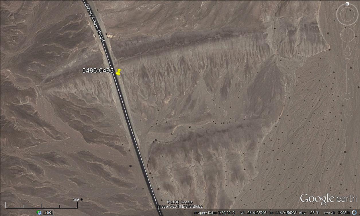 |
| Google Earth image showing two linear ridges (Google Maps link). The pin marks the approximate location of 3DV006-009 (the previous two photos and the next two). |
 |
| Bright desert gold (Geraea canescens) on brown, wrinkled hills of QTa (oldest alluvium). The dark hill on the right is part of the Death Valley Buttes, which is underlain by CZw, the Cambrian-Precambrian Wood Canyon Formation. |
 |
| Desert gold along one of the rills running southward off the linear ridge. |
While we were stopped at the roadcut through the liner ridge, a photographer told us we should look out for a particular desert five-spot that he had put a rock ring around, which would be up ahead near Milepost 8. Apparently the five-spot is considered one of the more beautiful of the myriad desert flowers, and it is sometimes described as rare.
We drove north up the cutoff road, diligently looking for Milepost 8. Just when we had given up on seeing any mileposts (where were they? hidden? were we distracted by wildflowers and geology??), we found MP 6. From there we counted our way slowly, and pulled over right next to MP 8. Where was the rock ring?
It wasn't far uphill from MP 8, right alongside the road.
 |
| Desert five-spot (Eremalche rotundifolium) inside a circle of rocks. |
 |
| A closeup of the same plant. |
The sun was low, we were hungry, so onward and upward we rolled, turning back to take one last photo or two looking south toward the mostly shadowed Death Valley.
 |
| Looking south toward the Death Valley playa. |
=========
This post ends the first day of our Death Valley wildflower trip, although I haven't yet posted about the Titus Canyon leg of this journey. Part 1 was here, Part 2 here. This is Part 3. There has been a geologic component to all of these posts, so far. How could there not be?I will probably now move all the way back to the beginning of our trip, which began two days earlier and miles to the north under cloudy skies. I'll work my way south to Titus Canyon, which may take more than one post. (Titus Canyon is huge, for geology!)
Greene, R.C., and Fleck, R.J., 1997, Geology of the northern Black Mountains, Death Valley, California: U.S. Geological Survey Open-File Report 97-79, 110p.
Hunt, C.B., and Mabey, D.R., 1966, Stratigraphy and structure, Death Valley, California [pdf]: U.S. Geological Survey Professional Paper 494-A, , 162 p.
Lengner, K.E., 2009, A trip through Death Valley's geologic past: Deep Enough Press, 66 p.
Lengner, K., and Troxel, B.W., 2008, Death Valley's Titus Canyon & Leadfield ghost town: Deep Enough Press, 175 p.
Miller, M.G., and Pavlis, T.L, 2005, The Black Mountains turtlebacks: Rosetta stones of Death Valley Tectonics [pdf]: Earth Science Reviews, v.73, p. 115-138.
Troxel, B.W., and Wright, L.A., eds., 1976, Geologic features, Death Valley, California [pdf]: California Division of Mines and Geology Special Report 106 [several articles].
Troxel, B.W., and Wright, L.A., 1987, Tertiary extensional features, Death Valley region, eastern California [pdf]: in Hill, M.L., ed., DNAG Centennial Field Guide v. 1, Cordilleran Section: Geological Society of America, Boulder, p. 121-132.
Workman, J.B., Menges, C.M., Page, W.R., Taylor, E.M., Ekren, E. B., Rowley, P.D., Dixon, G.L., Thompson, RRA., and Wright, L.A., 2002, Geologic map of the Death Valley ground-water model area, Nevada and California: U.S. Geological Survey Miscellaneous Field Studies Map MF-2381-A, Pamphlet text, Sheet 1, Sheet 2.
Wright, L.A., Otton, J.K., Troxel, B.W., 1974. Turtleback surfaces of Death Valley viewed as phenomena of extensional tectonics [abs.]: Geology v. 2, p. 53-54.
Bonus Photos:
 |
| The crinkly, wrinkled hills in a wider view. |
 |
| A zoomed view of desert gold and the Panamint Range, with Telescope Peak a little more apparent than in the earlier, wide-angle view. |
 |
| A wide-angle view from the linear ridge. |
All photos in this post were taken on Leap Day, 29Feb2016.
2 comments:
Hi! I just wanted to you to know I enjoy your blog. I am not sure how I found it but it was quite a few years ago now. I came to Nevada in 1991 running EM/Mag/VLF heli-borne surveys out of Tonopah and ended up surveying a good chunk of the I80 corridor from Winnemucca to Wendover and down to Eureka over the course of 2 years. I got out of the exploration game in the late nineties and actually ended up moving back to N. Nevada for a while. We plan to one day be back but your blog serves as a good road map to places never seen and old haunts that need to be revisited. Thanks and keep up the good work!
Thanks for reading, wayno, and for commenting! :-)
Post a Comment