 In continuing to clear out drafts and finish incomplete series or road trips, I'll take a leap back to October, 2009, when I was driving back from the annual GSA meeting in Portland. Last you knew, I was somewhere in northeastern Oregon, a mystery location replete with tipi, yurt, basalt, and larch.
From there, I took I-84 east to Twin Falls, Idaho, then went south on Highway 93 toward Jackpot, Nevada, with the full intention of making it in and out of Jarbidge, Nevada, in one day. With Jarbidge being a long way from everywhere, I didn't make it. Instead, I made it part way in, turned around, stayed in Jackpot (which I don't recommend unless you love stateline casinos, bring your own food, or both), then went in the next day. Both times, I turned off Highway 93 at Rogerson, Idaho, and went west toward the Jarbidge River across the east part of the Owyhee Plateau, south of the west-central Snake River Plain.
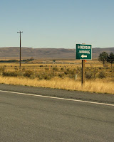
 On the way in—the first afternoon and then the next morning—I crossed over a narrow dam located here on the 3 Creek or Jarbidge Road. This is what the area looks like, from Rogerson to the drop-off into the East Fork of the Jarbidge River: generally flat with lots of basalt.
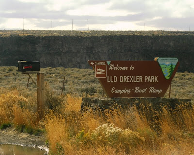
 After a slight turn in the road (previous photo), I came to the sign for Lud Drexler Park, which appears right before the one-lane passage across Salmon Falls Dam.
 This is a view to the south taken from the center of Salmon Falls Dam on Salmon Falls Creek. The dam was built across Salmon Falls Creek in 1908 to 1912 (history), creating Salmon Falls Creek Reservoir. Because of my convoluted way of approaching Jarbidge, I crossed over this dam three times. Had I known conditions in Jarbidge—they have year-round food, lodging, and gas, although calling ahead wouldn't hurt—I could have stayed there the first night.
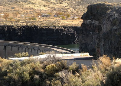
 Looking north from the center of the dam, one sees this canyon wall made of basalt. The basalt is probably Pliocene, has been mapped as part of the Banbury Basalt, a name which is not in use everywhere. Extending units mapped in quads to the north near Twin Falls, we could be looking at either the Pliocene basalt of Hub Butte or the Pliocene basalt of Burger Butte—or some other basalt entirely.
 Unfortunately, the one-lane road over the dam is not a good place to stop and look at rocks!
 I got a good view of Salmon Falls Creek Reservoir, which can be seen south of the highway, after driving west of the dam.
 On the second day, I stopped just beyond the dam, parked, and took a closer look.
 This is the one-lane road as seen from the west side—one has to stop when crossing from either direction and carefully look for oncoming traffic.
 The entire dam, as seen from the west on the second day.
 A close-up shot of water seeping out between basalt layers just below the dam.
 The shadows on the dam were great as I drove back towards Rogerson on the first day.
Some References: Digital Map of Twin Falls County, Idaho (click on Twin Falls): Digital Atlas of Idaho.
Kauffman, J. D, Othberg, K. L., Virginia S. Gillerman, and Garwood, D. L., 2005, Geologic Map of the Twin Falls 30 X 60 Minute Quadrangle, Idaho: Idaho Geological Survey, Map DWM-43, 1:100,000.
Lewis, R.E., and Young, H.W., 1989, The hydrothermal system in central Twin Falls County, Idaho: USGS Water-Resources Investigations Report 88-4152, 44p.
Othberg, K. L., Kauffman, J. D, and Virginia S. Gillerman, 2005, Geologic Map of the Twin Falls Quadrangle, Jerome and Twin Falls Counties, Idaho: Idaho Geological Survey, Map DWM-52, 1:24,000.
13 comments:
Wow. I suppose "leaks" like these might explain why the maintenance crew of the Teton Dam were insufficiently alarmed in early June, 1976.
The place seems so remote and tranquil! (sans the trailers parked in the background)
Ron, at least the dam doesn't look wet - I think the Teton Dam actually showed leaks or damp areas in the dam prior to collapse. Also, it was an earthen dam, probably some different considerations apply. Not sure what to think about the water coming out the basalt below the Salmon Falls Dam - looks like it's been seeping for quite some time, but I wouldn't want a house in the canyon below (which probably isn't possible, anyway).
JCC, the trailers are at the little park, maybe there for fishing and boating. The area is fairly remote and quiet, but the road shows signs of daily (or weekly?) rush-hour traffic in the afternoon at least.
The Jarbridge Mountains always intrigued me when I looked at the maps of NV in my UNR days, but I never made it out there. Thanks for the pictures! I was going to comment on Teton Dam and the leaky basalt, but Ron beat me to it (as usual).
Can't see them thar mountains in these photos!
That water seepage is pretty alarming! After seeing that it just makes you wonder if they are making sure it's safe to drive over.
I wanted to tell you that the picture titled "approach" is stunning! While all the pictures are beautiful, I just really liked that one in particular. I don't have an eye for photography, so even when I had a good camera my pictures still were pretty poor. Now I don't even bother and just use the iphone. (I notice no difference in quality with ME as the user..lol:)
The water seepage around the dam looks like it could cause some of those pillar-like basalt forms to collapse sometime in the future. I've been on bridges that I thought were in more danger of washing away while I was on them, e.g. during floods. Hopefully the local traffic and blm are keeping an eye on it.
Thanks for the photo compliment, CPanda (or should I just call you Cannibal for short - seems too much like Hannibal Lecter, though ;) ). Those little labels I attach to some photos (visible only when hovering w/ a mouse) are mostly so I can remember where to put the photos when I move them around! :)
I was brought up through the years with a couple of camera buffs and picked up a few design and shooting basics.
You're a brave one, being on a bridge you thought may wash out. I used to be terrified of bridges and tunnels years ago, but a stint of living in Virginia Beach cured that right up. :)
You can call me whatever is easiest for you- CP, Panda, Cpanda.. I'll figure out you're referring to me (eventually:) The name is a bit of a family joke, most likely only humorous to us, so I have never bothered to tell it's origins. I tried to come up with something more witty, but just ended up falling back on an old standby.
It's a gaming name I've used for years, and it was always available. It must be getting around though, as someone else has claimed a blog under my dear pseudonuym, making me put a number to the end of mine, to my utter chagrin. That's what I get for taking too long in starting a blog. ;)
The dam was built in 1910 by a local irrigation company that is still in existence and probably is the owner of the dam. BLM signs are all over the place but BLM's role is limited to the recreation facilities. The main goal of the owners is a cheap source of irrigation water and as a consequence are probably not interested in costly rehab work. The leaks around the right abutment have probably been there for decades and not perceived as a threat to the structure. The seeps appear to be clear indicating that there is no piping or other erosion. However, a field inspection by an engineering geologist might reveal more danger than your pic shows. A grouting program in the foundation rock of the right abutment might be appropriate. It would be important to know if the flow in the seep has increased in the last decade.
CP - I'll probably call you CP, not to be confused with CPP who doesn't comment here, or Cpanda, which is very unique. :)
Alaska Al, thanks for looking into this. I think your suggestion that we go on a grouting expedition is a good one. All we need is a couple drillers, a drill rig, some money, and one or two geologists. Know any? ;)
I might update information on this dam in a later blog post. (And now I know what a gravity dam is! I assumed it was an arch dam.)
The Salmon Falls Creek Dam has been leaking like that for more than 30 years. I don't think it is going to fall down. There is a major wind energy project proposed right up the road from the dam.
Anon, thanks for the info - we'd tentatively come to that conclusion, but as you can see, had a great discussion anyway. :)
Post a Comment