Friday, August 6, 2010

Oregon Trip Day 3: Hoodoos, a Snake, more Rhyolite, and Another Brewery

Continuing on toward central Oregon [this leg of the journey goes from Jarbidge, Nevada, to Baker City, Oregon, through the Snake River Plain], we awoke early in Jarbidge (NOT!), and took our leave of the town. Before leaving, though, we got a tour of the Red Dog Saloon, which is only open in winter.
Bar and cafe operations in Jarbidge, NV, are divided between the Outdoor Inn in summer and the Red Dog Saloon in winter. The reason for switching from one venue to the other is that the Red Dog is smaller and is therefore easier to heat during the cold, snowy winter months.

Here are a few other Red Dogs I've been to: Red Dog Saloon, Juneau, AK; Red Dog Saloon, Virginia City, NV; Red Dog Depot, Redmond, OR; and it seems like I'm missing one somewhere.

UPDATE 8Dec2013: Finally found the other Red Dog Saloon I've been to, located as always in Needles, CA. And here's one I've not visited.
Besides a few scattered Mormon crickets — which for some unknown reason were located mostly on the Idaho side of the road from Jarbidge to the Jarbidge Forks — we came across this rattlesnake hiding in the shade, looking to get run over. We promptly swerved while skidding to a halt.
I shot a few pictures of the snake coiling and poised to strike, but most of them came out blurry. The reason it was taking such a striking attitude? MOH was pushing it off the road with a stick, so it might not get run over or shot by anyone.
It finally did make it into the rocks by the roadside; we figured it might just come back out onto the nice, flat road where it would be in danger again, but don't know what went down after we left.
These are steep, roadside cliffs in the Cougar Point Tuff about half way between Jarbidge and the Jarbidge Forks (cliff location Google Maps), still south of the Idaho border in Nevada.

Photo: Cliff in the rhyolitic Cougar Point Tuff.

You can read a little about the Cougar Point Tuff here (Bonnichsen, 1991), and also in the my Day 2 trip report, where I show a couple close-up photos.
We had a hard time getting through this part of the canyon. Hoodoos kept popping up, especially above (and also below) a relatively thin and crudely columnar-jointed unit in the Cougar Point Tuff. We pulled into this pullout and to take pictures of these hoodoos...
...hoodoos that include this natural arch.

Photo: The Jarbidge Forks.

We finally made it, slowly but surely, to the Jarbidge Forks, which is in Idaho. The East Fork of the Jarbidge River, center and foreground of the photo, comes into the Jarbidge River, left part of the photo, and they both continue downstream to the right (north) as the Jarbidge River. We had been driving downstream along the Jarbidge River; now, for a relatively short distance, we would follow the East Fork upstream to Murphy's Hot Springs.

Photo: Some wild jointing and fracturing in the Dorsey Creek Rhyolite.

This is the Dorsey Creek Rhyolite at the Jarbidge Forks. It falls into the voluminous silicic lava flow category and erupted about 8 million years ago from sources within the Bruneau-Jarbidge eruptive center, which was centered downstream (north) of this Jarbidge Forks location. According to Bonnichsen, 1991, the Dorsey Creek Rhyolite is more than 650 feet thick in Jarbidge Canyon.
In this photo, also taken from the Jarbidge Forks, you can see some nice flow folding in the Dorsey Creek Rhyolite. Some of the flow foliation or folding in this large-volume rhyolite flow is similar to compaction or flow foliation present in densely welded to rheomorphic parts of the Cougar Point Tuff (photos in the Day 2 trip report). Distinguishing large-volume rhyolite flows from rheomorphic tuffs can be difficult.
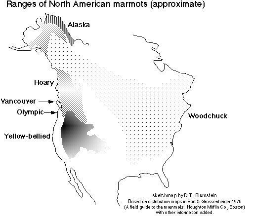
While driving through Murphy's Hot Springs, ID, we spotted this marmot, likely to be a yellow-bellied marmot, Marmota flaviventris, according to this distribution map.
And then we took the grade out of the canyon of the East Fork of the Jarbidge River, getting a nice view of the canyon with the Jarbidge Mountains in the background. That's all Cougar Point Tuff in the canyon walls (Bonnichsen, 1991).
The rest of our trip on the third day was fairly uneventful saving one more crossing of Salmon Falls Creek at across the one-lane Salmon Falls Dam...
...and a nice view of the Thousand Springs area near Wendell, Idaho, just before we crossed the Snake River on old Highway 30 (MSRMaps).

According to this sign, a lava flow — or more than one? — changed the "geologic structure" of the area, resulting in formation of the many springs.

"Over thousands of years, volcanic activity repeatedly spread lava over the Snake River Plain, slowly forcing the river southward in a great curve. Successive channels of the river and its tributaries were filled with spongy lava, and became both reservoirs and underground conduits, gathering water from far to the northeast. Torrents from one or more of these buried channels burst forth on the opposite canyon wall."
I can't vouch for this description, but it sounds plausible, if somewhat general.
Many hours passed as we drove west to northwest on I-84; we finally came to Baker City, Oregon, and settled into a motel. We then immediately walked over to Barley Brown's Brew Pub. We both had the WFO IPA (Wide *Freaking* Open) and had a taste of the Hot Blonde, which is brewed with jalapeƱo peppers and went well with the south-of-the-border–style Ceasar salad I had. Highly recommened! Their beers as of more than a year ago.

Trip report to be continued...

Some References:
Bonnichsen, Bill, 1982, The Bruneau-Jarbidge Eruptive Center, Southwestern Idaho, in Bill Bonnichsen, and Roy M. Breckenridge, eds, Cenozoic Geology of Idaho: Idaho Geological Survey Bulletin B-26. p. 237-254.

Bonnichsen, Bill, 1991, Geology of Scenic Jarbidge Canyon Near Murphy Hot Springs, Idaho: Idaho Geological Survey, GeoNote 16, 2 pp.

Bonnichsen, Bill and Jenks, M.D., 1990, Geologic map of the Jarbidge River Wilderness Study Area, Owyhee County, Idaho: U.S. Geological Survey, Map MF-2127, scale 1:50000.

Cathey, Henrietta E, and Nash, Barbara P., 2004, The Cougar Point Tuff: Implications for Thermochemical Zonation and Longevity of High-Temperature, Large-Volume Silicic Magmas of the Miocene Yellowstone Hotspot: Journal of Petrology, v. 45, no. 1, p. 27-58.

Henry, C. D., and Wolff, J. A., 1992, Distinguishing strongly rheomorphic tuffs from extensive silicic lavas: Bulletin of Volcanology, v. 54, no. 3, p. 171-186 (links to abstract).

Starkel, W. A., Bonnichsen, B., Godchaux, M., Boroughs, S., and Wolff, J., 2006,
Far-Travelled High-Grade Ignimbrites or Widespread Generation of Low-d18O Magma? The Problem of the West Bennett Hills, Snake River Plain, ID: American Geophysical Union, Fall Meeting 2006, abstract #V51D-1704.

Wednesday, August 4, 2010

Oregon Trip Day 2: A Hike near Jarbidge across Two Rhyolites

Photo: Jarbidge mine dumps and fireweed.

On our long trip to and from Oregon, we dedicated our only full day in Jarbidge to hiking, although we also walked around town and up canyon in the evening. Overall, it was a good day, with clouds providing some relief from the hot sun, while also contributing to an unusual dampish humidity.
The steepness and plant overgrowth at the base of the hillslopes in the canyon of the Jarbidge River forced us onto a road — the road shown as a jeep trail on this map. We hiked from the base of Moore Gulch, past Cottonwood Spring, to the saddle overlooking Jenny Creek. The road was steep and rocky, especially over the first mile, and partly followed an old powerline.
Photo: Jarbidge Rhyolite in the the road.

The layering in the slabby bedrock sticking out of the road is probably flow layering; the rock is the Jarbidge Rhyolite — a crystal-rich rhyolite, often hydrothermally altered, which hosts the gold-bearing quartz-adularia veins of the Jarbidge mining district. The Jarbidge Rhyolite is about 15.5 to 17 Ma (from two dates by Coats, 1987, from elsewhere in northeastern Nevada).

Notice the rocks scattered over the road. The rhyolite weathers to a coarse grus-like material that made going uphill interesting and going back downhill downright slippery.
Photo: Hand sample of the Jarbidge Rhyolite.

This is the culprit! The yellow-brown to reddish-orange to brownish weathering, pink and white, crystal-rich rock weathers into sub-rounded chunks, creating a road surface remindful of a bunch of ball bearings.
We stopped for many breathers, especially after surmounting the lower, scrabbly part of the road. This view, across the canyon of the Jarbidge River toward the west, looks along an old, defunct powerline.
Oh, even more steep and rocky clambering. Is that shade up ahead?
About an hour into the hike, we came to a patch of aspens and other trees. The road flattened out a little, and the rocky ball-bearings disappeared.
The linear groves of aspens, sub-alpine fir, limber pine, whitebark pine, and possibly white fir (a second, unidentified fir-like tree downhill from us, not reported online as part of the Jarbidge flora) were just rich with wildflowers.
Needless to say, we took some time walking through this green, shady scene.
Mariposa lily, possibly Calochortus bruneaunis AKA Bruneau mariposa lily.
Unknown, but seen especially on the lower slopes.
Beyond the trees, we go ever upward, but at a more leisurely pace.
Wildrye, what I used to know as Elymus, probably now Leymus cinereus or Basin wildrye.
Photo: Partly devitrified, flow- or compaction-foliated rhyolite.

As we approached the saddle, the soil became dark, apparently from weathering of a dark gray to brown, glassy, flow-banded rhyolite, the Cougar Point Tuff, which is about 10.5 to 13 Ma. The strongly flow-banded rhyolite was variably devitrified, locally forming gray, subrounded balls similar to Apache tears, but dull and much less glassy in character. The banding or foliation could be the result of compaction or flow or both.
Photo: Folded flow-foliation in the Cougar Point Tuff near the top of the saddle.
Photo: Flow lineations in the flow-banded rhyolite.

Flow lineations can be seen above my boot and below the whitish-looking lichen. This kind of flow foliation in extremely welded or high grade ash-flow tuff is common in high-silica to peraluminous welded tuff formations, making it difficult to distinguish these types of tuffs from rhyolite flows in the field.
Photo: Brownish outcrop of Cougar Point Tuff.

After walking to the saddle, in hopes of seeing a grand view to the north or west but instead finding only another canyon, we sat down and rested against some brown-weathering flow-banded rhyolite.
We took in the view looking southwest toward Jarbidge, and then walked down. You can see a couple of the linear, downhill-oriented patches of evergreen trees. Surprisingly (at least to me), a few of the subalpine fir make it almost all the way down to the canyon floor.

Elevation gain: about 850 feet. Distance total: about 5 miles. Time from start to finish: about 3 hours. Both gain and distance include walking to and from the motel. Other plants found besides those mentioned: sagebrush, Woods' rose, antelope bitterbrush, alder or water birch., and many, many unidentified or unmentioned others.

Trip report to be continued...

Some References:
Bonnichsen, Bill, 1991, Geology of Scenic Jarbidge Canyon Near Murphy Hot Springs, Idaho: Idaho Geological Survey, GeoNote 16, 2 p.

Cathey, Henrietta E, and Nash, Barbara P., 2004, The Cougar Point Tuff: Implications for Thermochemical Zonation and Longevity of High-Temperature, Large-Volume Silicic Magmas of the Miocene Yellowstone Hotspot: Journal of Petrology, v. 45, no. 1, p. 27-58.

Coats, R. R., 1987, Geology of Elko County, Nevada: Nevada Bur. Mines and Geology, Bulletin 101, 112 pp (links to sales info).

Jewell, P. W., Rahn, T. A., and Bowman, J. R., 1994, Hydrology and Chemistry of Thermal Waters Near Wells, Nevada: Ground Water, v. 32, no. 4, p. 657 - 665 (links to abstract).

Flow banding and rheomorphic deformation at Magma Cum Laude, January, 2011.

Monday, August 2, 2010

Oregon Trip Day 1: A Brewery, Some Geology, Wildlife, and Other Stuff

I just returned from a mega-trip with MOH into central Oregon, where I met with family at an annual reunion-type affair on a basalt-capped bluff overlooking a small Oregon town. We spent four days getting there, spent three days there, and rushed back in two days.

Our first stop was the Ruby Mountain Brewing Company at Angel Creek Ranch, which is a little south of Wells, Nevada.
The brewery is a small affair on an operating ranch along the eastern range front of the East Humboldt Range. We had a taste of two brews, then purchased a couple cases, which we took with us for delivery to the reunion, keeping it cold in a large ice chest in the back of the Prius.

We like the Angel Creek Amber Ale and the Buckaroo Brew Pale Ale. The pale ale, which isn't listed on their website, was originally made for the Western Folklife Center and the National Cowboy Poetry Gathering in Elko.

Be sure to call ahead if you plan to visit this brewery, otherwise they might be out dealing with cows, horses, hay and the like.
Photo: Leaving the Great Basin; Mesas are capped by welded tuff.

After driving north on Highway 93, we crossed the California Trail and then left the Great Basin by dropping into the Snake River drainage region. The photo looks a little north of northwest from Highway 93 near Henry (Google Maps Street View). The mesa on the very left is Big Devils Table, the mountain on the right is Ellen D Mountain, and the main drainage cutting the mesas a little right of center is Salmon Falls Creek (MSRMaps). According to this map, the dark brown mesas are capped by Tts, which includes ignimbrites and tuffs of the Idavada Formation and may include the rhyolitic Cougar Point Tuff (Tcp). Sediments mapped as Ts3 underlie the capping rhyolitic tuffs. The dark-brown mesas look like basalts from a distance but aren't.
Photo: Dipping beds and granodiorite.

After making a turn to the northeast, the road goes toward the siding of Contact and passes by China Mountain, where you can see some sedimentary layers (center and right) dipping moderately to steeply to the south, away from a granitic pluton (left). The plutonic rocks are mapped as Jgd (Jurassic granodiorite) on the same geologic map; the seds are mapped as PMl (Upper Mississippian to Lower Permian limestone, along with shale, chert, orthoquartzite, and siltite). The intrusive contact between the sedimentary and plutonic rocks might be what the siding of Contact is named for; it also might be named for the contact-metamorphic mineral deposits and prospects of the Contact mining district. This aerial photo shows the beds and contact fairly well.
Photo: A closer view of the intrusive contact.

Highway 93 then cuts through the Jurassic granodiorite for at least a few miles, providing ample opportunity for closer viewing at roadcuts.
We drove by an old hot springs south of the NV-ID border and wondered about its status, but didn't check it out. It's not listed in my hot springs books, and not shown on the topo maps (building is in the upper center of this air photo).
We crossed Salmon Falls Creek not once or twice (above), but three times, the third being a crossing at Salmon Falls Dam.
After what seemed like a long trek on the Jarbidge Road across variably flat to hilly country with the occasional canyon, we dropped into the canyon of the East Fork of the Jarbidge River heading for the Jarbidge Forks. In my two drives down and one drive up this part of the road, I was too busy looking at the canyon to notice this man-made rock wall.
A view of the rock wall looking straight up: the wall is on the left, it then meanders over to the center where it joins a horizontal flow basalt capping the ridge.
We took a quick drive through Murphy's Hot Springs, which doesn't have an active commercial operation at the moment — but maybe it's for sale! Murphy's Hot Springs is mostly a small, private settlement, with at least one road crossing the East Fork of the Jarbidge River.
We arrived in Jarbidge after very slow driving on the narrow, one-laned road (read more about the road in here). We checked in, checked the place out, and went for a walk around town, where we flushed out a deer or two.
We didn't see any dingoes.
There are a lot of old pieces of this and that kind of equipment and relics around town, including a photogenic old CAT from an unknown era.
Finally, we stopped in at the Outdoor Inn, whose sign boasts "Booze, Grub, Rooms."
This is the current beer selection. MGD? Or a Ruby Mountain ale?

Trip report to be continued...

Some References:
Bonnichsen, Bill, 1991, Geology of Scenic Jarbidge Canyon Near Murphy Hot Springs, Idaho: Idaho Geological Survey, GeoNote 16, 2 p.

Hope, R.A. and Coats, R.R., 1976, Preliminary geologic map of Elko County, Nevada: U.S. Geological Survey, Open-File Report OF-76-779, 1:100,000.