Thursday, January 10, 2013

Kitty Ice Prints...

...or icy kitty prints?

I'm not much of a cat blogger, but I saw paw prints in the making the day before yesterday, when a couple kitties jumped up on the jeep right after it had been washed, leaving dusty prints all over the hood! The kitties were, apparently, interested in drinking water from the bowl-like indentations where the windshield wipers swivel, because all other water that afternoon was in the form of snow and ice.

The next morning, after an ice fog had partly lifted, the hood of my jeep looked like this:
Frozen cat prints on jeep hood.
Enlarged prints.
More prints.
More enlarged prints.
Little ice crystals comprise the frozen prints.
As Jim Lehane recently noted, ice is the solid, crystalline form of water. Ice crystals are hexagonal; the ones on my jeep were too small to examine without my hand lens — and I didn't stay outside long enough in the icy morning air for that!

Ice at Mindat.org
Ice at Webmineral.com
Is Water a Mineral? -- Is Ice a Mineral?

Monday, January 7, 2013

Deskcrop: Dumortierite and Dumortierite-Sericite Schist

These various rocks had been lying around on my kitchen table for weeks when I decided to photograph them together, along with a Bailey's glass filled with wine and an empty Alaska cup. Clockwise from the Bailey's glass: dumortierite-sericite schist with rose-colored dumortierite, greenish dacite porphyry from the Osgood Mountains, reddish volcanic rock from the Midas area, and lavender dumortierite schist.

The dumortierite-sericite schist is a from the Champion Mine area, located in the Rochester mining district of the Humboldt Mountains, Pershing County, Nevada.

Dumortierite-sericite schist, composed mostly of dumortierite, sericite (AKA fine-grained muscovite), quartz, and possibly andalusite.
Sheen from the fine-grained, clear to white sericite (muscovite) on foliation planes and disseminated in the schist.
Lavender dumortierite schist.
I found this one piece of lavender dumortierite schist on the ground below the chute of the ore bin between the upper and lower Champion Mine workings.

Dumortierite has been mined for use in making refractory ceramics such as those used in spark plugs. It is sometimes used as a gemstone (or rock), and the blue varieties have sometimes been used to make fake lapis lazuli.

By the way, these rocks are currently unlabeled. Andrew Alden has a good post up recommending that everyone label their rocks and minerals (with name and location or provenance). I will be able to label precisely all but the reddish volcanic rock.

Related Posts:
Friday Photo: Dumortierite
The Road to the Champion Mine
Rock Walls at the Champion Mine Lower Workings
Dumortierite at the Champion Mine, Nevada
Upper Champion Mine Workings

Selected Reference:
Mackay School of Mines staff, 1928, A bulletin by the Mackay School of Mines staff on the mineral dumortierite, University of Nevada Bulletin, vol. 22, no. 2: Nevada Bureau of Mines and Geology Bulletin 8, 47 p., including 1 oversized page.

Sunday, January 6, 2013

Notes from the North: Birch and Spruce Falling on Snow

About two days after our first hike while we were up in the northlands, a Chinook wind came up, blowing from the southeast across the Kenai and Chugach Mountains toward town. Temperatures rapidly went from the mid-teens to about 35 to 45°F. The main roads became icy, then slushy, then dry, with back streets turning into solid glare ice for several days. I prefer temperatures to be at 20°F or lower when driving on icy roads.

Tree stump with layered corn snow.
On our hike that first Chinook day, snow in the area was melting, turning from a dry, powdery snow to an icy corn snow. We could see layers in the snow, counting eight on one flat surface. Tree litter, dominantly from black spruce but also from birch, lay all over a snow surface pockmarked by rain drops and drips from tree limbs and branches.

Spruce twig and cone on pockmarked snow.
Dried birch leaf and other litter on snow.
Dried Devil's club branch or flower on snow.
We hiked on the trail with metal chains on our boots. The chains iced up frequently, making walking awkward. Overall, it was quite a different scene than the hike two days prior.

An aside: Wind directions recorded by the Weather Underground don't make any sense to me, unless they show the direction the wind is blowing toward, opposite from standard protocol. Their recordings indicate winds shifting from being generally easterly to being variable and generally westerly to northerly.

Wednesday, January 2, 2013

Great Basin Dotmap

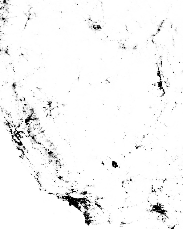
I thought I'd have a little more fun with the Census Dotmap I posted about a couple days ago, by conjuring up a shot of the Great Basin:

Screenshot from Census dotmap by @ewedistrict and @kieran.
The dotmap highlights the lack of people living inside the Great Basin. Instead, the bulk of the population is outside, or is located around the edges (Salt Lake City, Las Vegas, Reno). The northern boundary of the Great Basin is vague in the dotmap view, but the Snake River Plain to the north of the Great Basin's northern edge is easily identified. The northwest and southwest boundaries, near Goose Lake and Death Valley respectively, are also somewhat vague on the dotmap.

Two more views of the Great Basin:
Greatbasinmap by Kmusser [CC-BY-SA-3.0], via Wikimedia Commons.
Great Basin in magenta, from National Park Service.

Tuesday, January 1, 2013

2012 Top 10 Posts at LFD...

...and a few more.

Because of the vagaries of stat reporting (in this case, by Google Analytics), I'm listing the both the top ten posts for the year (in large font, with respective Top Ten number), and the top two posts for every month (non-ten-rated posts are in a smaller font). One reason for going on to listing the top two posts per month (or four posts in one particularly popular month, February), is that post ratings for the last few months of every year, as indicated by stats, are not as reliable as post ratings for earlier in the year (ratings are not static and change as time goes on).

As usual, the year started out with a bang. Some of the tapering of top posts (and certainly all of the tapering of my number of posts per month) resulted from me not having as much time to blog starting in mid-March or so; some of the apparent tapering of top posts is a result of the way stats accrue per post, with the last three months of 2012 garnering zero Top Ten posts so far, but maybe one or two of those posts will actually make it into the Top Ten by the middle of next year. Also, FWIW, I have noticed quite a drop in blog hits over the last two months, starting with NaNoWriMo, when presumably everyone was writing, and perhaps fewer people were reading.

And so, here are the Top Ten posts, with a few extras so that each month shows at least the top two posts for that month, giving us a total of 26 posts.

January
A Soak at Spencer Hot Springs #5
Stop Censorship Header | Stop SOPA Links #7

February
De Re Metallica #1
South of Center: Potts Ranch #3
Top Ten Reasons I love detachment faults / core complexes #4
ENE of Center: Breccia at Devils Gate #8

March
Goodbye... #10
Backroads: Too Cold to Change a Flat, and other Considerations

April
SW to SWxS of Center: West Northumberland Canyon
Views from Winnemucca Mountain

May
Wedge #45: Geological Pilgrimage
Busy Days!

June
American 101 Geo-Sites Meme #9
Field Book Scribbles

July
Geo-beers: Gimme an Icky #2
Two Spots on the Humboldt River

August
Smoke in the Black Rock & Smoke Creek Deserts
Pinnacles above Midas

September
Mud Pot at Sulphur Works #6
Views of Lassen

October
Geologic Map Day
Accretionary Wedge #50: The Fire at Field Camp

November
V is for Vein
Friday Photo: Dumortierite

December
Rock Walls at the Champion Mine Lower Workings
Dumortierite at the Champion Mine, Nevada