
 |
| A Google Earth view of The Crater and associated basalt flow rock. |
 |
| The cone is right beside S.R. 265, just north of Milepost 4, between Silver Peak and Blair Junction (see the map below). |
 |
| Click to enlarge this location map, the spliced and labeled Tonopah and Silver Peak 30x60 sheets, courtesy USGS. |
 |
| The Crater, looking southeast from its northwestern flank. |
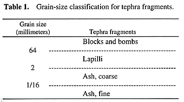 |
| A basic grain-size classification scheme for tephra, pyroclastic fragments that were thrown out of volcanoes, courtesy USGS. |
All the other references I found state that the cone is about 390,000 years old without providing credit to an original source.“...the basalt has been K/Ar-dated at ~400,000 years (J. Witter, pers. comm., 2008), but this age is at odds with the cone’s barely-disturbed morphology. Accordingly, Witter has submitted a sample of basalt flow rock, clearly sourced from the cinder-cone vent (Figure 3B) for more reliable 40Ar/39Ar age-dating.”
After parking and getting out of the truck, I walked around for a little while, trying to find some good examples of volcanic bombs. Rather than collecting any hand samples, I took a few photos.
 |
| Vesicular basalt. |
 |
| Volcanic bomb with a ropy or fluted texture. |
 |
| This could be a bit of flow or cooling texture in a basalt lapilli, but I'm not sure. |
 |
| A large block of basalt with ropy and vesicular texture. |
 |
| And here's a closer shot. |
 |
| Here's a bomb with fluted texture, approaching spindly. |
 |
| A spiny bush and a prickly pear cactus growing on a desert pavement of basalt lapilli, small blocks, and bombs. |
 |
| We can see the Weepah Hills and bluish Lone Mountain off to the northeast, beyond the dark, lower slopes of The Crater. |
Selected References:
Albers, J.P., and Stewart, J.H, 1972, Geology and mineral deposits of Esmeralda County, Nevada [available for sale only]: NBMG Bulletin 78, 80 p.
Hulen, J.B., 2008, Geology and Conceptual Modeling of theSilver Peak Geothermal Prospect,Esmeralda County, Nevada: unpublished report for Sierra Geothermal Power Corporation, 23p.
Price, J.G., and Price, E.M., no date, Cinder cone in Clayton Valley, Esmeralda County, Nevada: NBMG, Nevada EarthCaches webpage (with .kmz downloads available), accessed 18Feb2016.
Spurr, J.E., 1906, Ore Deposits of the Silver Peak Quadrangle, Nevada: U.S. Geological Survey Professional Paper 55, 174 p.
Related Posts:
Thesis: Finding an Area
Finding a Thesis: Battle Mountain to Austin to Gabbs
Finding a Thesis: Pole Line Road
Finding a Thesis: Pole Line to Belmont
Finding a Thesis: Klondyke District
Finding a Thesis: A Joshua Tree Aside
Finding a Thesis: Into the Palmetto Mountains
Finding a Thesis: Farther into the Palmetto Mountains
Finding a Thesis: A Bit O' Geology in the Palmetto Mountains
Finding a Thesis: Future Stories from the Palmetto Mountains
Lida Summit Roadcut
Finding a Thesis: Next Stop, Silver Peak!
Finding a Thesis: Coming into Clayton Valley
Finding a Thesis: On the Southern Route to Mineral Ridge
Finding a Thesis: The Northern Route onto Mineral Ridge and a Little Geology
Finding a Thesis: Up to the Millsite and Back
Finding a Thesis: Views and Geography and ... Oh, What's That?
No comments:
Post a Comment