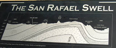
The first photo above was taken from I-70 looking south, from an overlook or viewpoint located near the center of the San Rafael Swell. The location is identified as the "you are here" position on the second photo. The white sandstone layers in the foreground of this first photo probably consist of the Jurassic Navajo Sandstone. Some stratigraphic information can be found at here, and the third photo above (from this website) shows some of the stratigraphy for the San Rafael Swell, with the San Rafael monocline or "reef" on the east side of the cross-section.
Above, the fourth photo looks northward from I-70 and shows the white upper part of the Navajo Sandstone cliff and the reddish lower part of the Navajo Sandstone cliff in the middle foreground, with the reddish ledge and slope-former below the sandstone cliffs possibly consisting of the Kayenta Formation - but it's possible the the sandstone cliffs include the Navajo Sandstone, the Kayenta Formation, and the underlying Wingate Formation sandstone, with the reddish slope-former then being part of the Chinle Formation. The Book Cliffs of Mancos Shale are the lower cliffs in the background, and the Roan Cliffs (the Green River Formation?) behind them. The brownish to golden slopes below the Navajo Sandstone may be part of the Chinle or Moenkopi Formations - but maybe not. This fourth photo shows the rock formations in the eastern part of the San Rafael Swell, just as one is about to drop over the edge and drive across the monocline or reef.
Above, the Navajo Sandstone and underlying Kayenta Formation (?) show an abrupt change in dip as beds steepen in approach to the San Rafael Reef or monocline.
I-70 is about to drop precipitously over the edge of the monocline.
The last photo, above, looks southward from a rest stop on the east side of the monocline. The steep rock formations of east side of the anticline (San Rafael Swell) can be seen on the right side of the photo - Kim at All of My Faults are Stress-Related, has a much better photo of the San Rafael monocline or "reef" on the east side of the Swell; she also explains the structure and formation of the San Rafael Swell and monocline.
Other links worth checking out:
Castle Country has some photos, information, and links.
More links and photos at sanrafaelswell.org
A Guide to I-70 through Southeastern Utah
The geology of central and southeastern Utah: Itinerary for a one-day field trip
The blog Running Away has some great photos of the Swell.


3 comments:
Those are some gorgeous landscape fotos!
I think the Swell is one of my favorite place out that-a-ways.
Nice photos!
Thanks for the nice comments. I have now edited this post and put the photos in the right order! What wonders a cursor can do!
(Original comment was: Wed May 14, 05:50:00 AM PDT)
Post a Comment