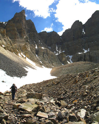
 So, we kept on hiking up the rock glacier because, after all, that's what hiking trails are for. There's MOH, hiking on the trail. Do you recognize the trail? It's the slight indentation in the generally rocky field of the rock glacier. We're still on its lower part (trust me on this one!).
 The lighting was dramatic at times, due to some puffy cumulus clouds that developed in the afternoon. I took a few pictures as the lighting changed, first some shadows here, then there, shadows moving all around. In the photo above, you can see the rock piles of the lower part of the rock glacier in the foreground, with the cirque headwall of Wheeler Peak (that's the peak!) in the background.
 Here's a close-up view of the snow/ice chutes feeding the small glacier hidden behind the upper part of the rock glacier. The bergschrund seen by Osborne and Bevis (2001) was just below the kind of triangular rock exposure in the center of the lower part of the ice/snow chute. The bergschrund, if present, can't be seen from this angle. So we'll have to climb higher! I hope you're not becoming affected by the altitude: we're at about 11,320 feet or about 3450 meters, depending on exactly where we are located.
 Above, more of the interesting lighting, showing the ice/snow chutes above the glacier.
 Oh hey, we came upon this neat little glacial lake (or pond), just before starting the climb to the upper part of the rock glacier. The water and melting ice or snow fills some small, irregular depressions in the lumpy rock glacier.
Reference:
Osborn, G. and Bevis, K., 2001, Glaciation in the Great Basin of the Western United States: Quaternary Science Reviews 20, 1377-1410.
Wheeler Peak is inside Great Basin National Park
6 comments:
Those images are so cool! Me is so jealous! ;-)
hmm...does it qualify?? I wonder. Beautiful pix.
Wayfarer, so many questions about this rock glacier, I think.
Lost,thanks for enjoying the pictures.
Well, this is what I did my dissertation on... LOL So I can answer some of your questions, but not at 11pm at night. :) I'll try to post something in response this week. I really miss that part of the world!!!
John, would love to hear what you know about the geology of the area. Looking forward to your post!
John, I just updated references on my Near the Top post to include your dissertation and links to your webpage.
Post a Comment