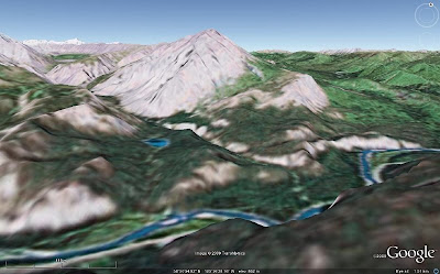
 Just pretend that you are still on the Alcan, in that in-between place between Toad River and Muncho Lake in northern British Columbia, Canada. You've just driven to the famed Folded Mountain turnout, pulled out to read the sign, and are now looking at Folded Mountain. If you look to the north, you'll see views like the two I've so cleverly created from Google Earth: the first one, above, looking north from about 450 m above the ground; the second one, below, looking north from just as close to ground level as I could get Google Earth to go, 60 m above the ground.
 I don't usually have a hovercraft with me while driving the Alcan, so I usually look at things from ground level, having never spent enough time on the highway to do any hiking around. A hovercraft could, however, be a useful thing to have on this supposedly paved highway: it always seems like major - I mean major - road construction is in progress somewhere along the way. Too bad I don't have photos of some of the boulder fields I've driven through on the supposedly paved highway.
 Suprisingly, a 1993 photo taken from or near the Folded Mountain turnout looks very similar to the second Google Earth image, but in the photo you can actually see some of the folds. And someone has drawn on the photo, approximately outlining some of the folds. Please ignore the pen lines on the upper part of the mountain - that part is too obscure for drawing to be of any use whatsoever - without having the actual mountain handy (which it's not).
Soon, we'll move just a little farther along the road to Muncho Lake, but first I must take a break. Farther up the road, my drawings will become a little more sophisticated. (But not because of the break!)
1 comment:
loved the quote on detachment
god bless
Post a Comment