 We arrived
 at
Summit Lake Lodge, which is for sale in case you are interested, in time for a slightly late lunch.

A friendly bear greeted us...

...so we went on in, found a place, and sat down. Summit Lake Lodge has good food, good beer, a good atmosphere, and a good view.

Sometimes it's worth stopping at the gift shop at the south end of the parking lot - to get milkshakes, espresso, T-shirts, or other gift-type items.


After lunch, we headed south on Alaska Route 1 to Tern Lake, where the Seward Highway continues south to Seward as Route 9, and the Sterling Highway continues west towards Sterling, Soldotna, Kenai, and Homer as Route 1.
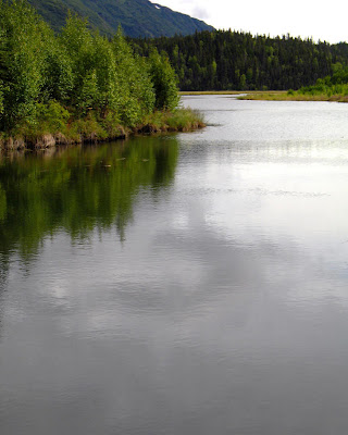
Tern Lake is a great place to stop to see wildlife, to stretch your legs, and to get a good view of more mountains and another great U-shaped glacial valley, seen above looking southeast towards Moose Pass.

As you drive away from Tern Lake, to the west and back toward the Sterling Highway, you'll have ample opportunities to stop and examine several metagrawacke roadcuts like the one above, which is cut by a network of quartz veins. In fact, you can't miss seeing the slaty graywacke, even if you don't stop at Tern Lake - there are several good collecting places here and there near the triangular junction of the Sterling and Seward highways.

Suddenly, the parental driver (my dad) took a sharp left turn, and we headed into the woods toward the Tern Lake campground.

A short walk from a little pullout on the dirt road before the camp will take you to Dave's Creek, a good place to view spawned out red salmon.

The red salmon, or sockeyes, are still hanging around, some going barely going upstream, most barely holding their own against the current.
Above, the photo looks back toward Tern Lake at the head of Dave's Creek. Downstream and to the west, Dave's Creek joins Quartz Creek and empties into
Kenai Lake near Cooper Landing. It's amazing: all these lakes have creeks and rivers going into them and out of them, and
all of them eventually empty into the ocean! (Well, maybe I've been in the Great Basin too long - actually thinking that lakes and oceanward drainage are amazing.)

The road goes on, pointing more-or-less toward
Redoubt Volcano, which can't be seen through the clouds on this particular day.

Finally, then, we found the right turn-off from the Sterling Highway, and we made our way on pavement and the dirt to the cabin - seen above in an earlier rendition before it was lifted off the ground after the September 1995 flood, which occurred not long after the painting of this strange picture.

 We arrived at Summit Lake Lodge, which is for sale in case you are interested, in time for a slightly late lunch.
 A friendly bear greeted us...
 ...so we went on in, found a place, and sat down. Summit Lake Lodge has good food, good beer, a good atmosphere, and a good view.
 Sometimes it's worth stopping at the gift shop at the south end of the parking lot - to get milkshakes, espresso, T-shirts, or other gift-type items.
 After lunch, we headed south on Alaska Route 1 to Tern Lake, where the Seward Highway continues south to Seward as Route 9, and the Sterling Highway continues west towards Sterling, Soldotna, Kenai, and Homer as Route 1. Tern Lake is a great place to stop to see wildlife, to stretch your legs, and to get a good view of more mountains and another great U-shaped glacial valley, seen above looking southeast towards Moose Pass.
 As you drive away from Tern Lake, to the west and back toward the Sterling Highway, you'll have ample opportunities to stop and examine several metagrawacke roadcuts like the one above, which is cut by a network of quartz veins. In fact, you can't miss seeing the slaty graywacke, even if you don't stop at Tern Lake - there are several good collecting places here and there near the triangular junction of the Sterling and Seward highways.
 Suddenly, the parental driver (my dad) took a sharp left turn, and we headed into the woods toward the Tern Lake campground.
  A short walk from a little pullout on the dirt road before the camp will take you to Dave's Creek, a good place to view spawned out red salmon.
 The red salmon, or sockeyes, are still hanging around, some going barely going upstream, most barely holding their own against the current.
 Above, the photo looks back toward Tern Lake at the head of Dave's Creek. Downstream and to the west, Dave's Creek joins Quartz Creek and empties into Kenai Lake near Cooper Landing. It's amazing: all these lakes have creeks and rivers going into them and out of them, and all of them eventually empty into the ocean! (Well, maybe I've been in the Great Basin too long - actually thinking that lakes and oceanward drainage are amazing.)
 The road goes on, pointing more-or-less toward Redoubt Volcano, which can't be seen through the clouds on this particular day.
 Finally, then, we found the right turn-off from the Sterling Highway, and we made our way on pavement and the dirt to the cabin - seen above in an earlier rendition before it was lifted off the ground after the September 1995 flood, which occurred not long after the painting of this strange picture.
5 comments:
Hey S.F., there's a post over in LOLscience I'd like to get out into the geoblogosphere- hope you can help. Here's the link. It's a bunch of great anthropogenic construction on tectonically active constructions... with captions! Enjoy!
Hey Lockwood, you have a bit of geology on your blog along with other things, and so I just added you to my GeoBlogoSphere links. So put the LOLthingstuff on *your* blog!
Thanks! The GBS seemed pretty focused on geology, and I don't really want to restrict myself. I know my geo pretty well, but haven't been very confident of my fit with this community. I appreciate the shout-out! I'll post it myself.
This was an especially beautiful series of pics. I really like the road one.
Thanks, EGF, appreciate the comment!
Post a Comment