 It started out as an average, desert day in Fernley - a bit windy, but average.
 By the time we reached Hazen, things were looking just a little dusty, and flags were standing completely sideways, the wind from the west.
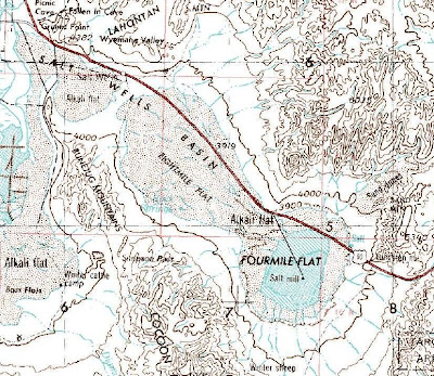
 MOH, ahead of me, swings into the turn just beyond Grimes Point. We will now traverse the entire length of Salt Wells Basin, which includes Eightmile Flat and Fourmile Flat, two usually dry playas, formerly part of Pleistocene Lake Lahontan.

 As we approach Sand Mountain - shown as "Sand dunes" north of Highway 50 on the above topo map - the blowing sand has completely enveloped what is often a large RV city on the east flank of the dune (right side of the photo).
 And then we pass straight into the path of the dust and fine sand as it crosses the road just before the turnoff to Sand Mountain.
 Ah, but the trip isn't over: we've now gone over Sand Springs Pass, and will cross LaBou Flat in Fairview Valley. Thermal updrafts below the overhead cumulus clouds are drawing dust off the valley floor, but not causing the rotation that creates true dust devils.

 The above three photos show the dust in Fairview Valley, the first two looking to the east, the third looking southward from about the center of the valley, near the old site of Frenchman.
 Finally, we have crossed Fairview Valley, have crossed Stingaree Valley, and are entering the notch in the western part of the Clan Alpine Mountains, which is called West Gate.
 As we arrive at Middlegate Junction - an old stage station between West Gate and Middlegate, the first two of three geographic notches that old Highway 50 passes through - we see that dust is still blowing. [The current path of Highway 50 makes it through only West Gate and Middlegate, missing Eastgate by a short few miles.]
More on Dust
Wind and Deserts

No comments:
Post a Comment