Friday, May 30, 2008
Fossil Friday
Some fossils of probable Devonian age for your Friday enjoyment. These are tiny little things next to small, daisy-like flowers, with the small gastropod-like fossil in the first photo being about 1/2 inch across.
Some fossils in this general section look like gastropods, possible fusulinids, possible corals, brachiopods, clam-like things, and maybe some crinoids. The formation is mapped in one fossiliferous location as the Devonian Simonson Dolomite, and in another fossil-rich location it seems to be mapped as the Devonian Guilmette Limestone -- although rocks and fossils look the same to me. I haven't seen much of the Simonson, but I could easily be convinced that it's the Guilmette. Sorry -- I haven't tried fizzing any of these yet!
If you know the real names of any of these fossils, let me know!
Thursday, May 29, 2008
Libations
I took coconino's recent advice and went out for some libations, this time going to a fairly new (or newly reopened) restaurant. I'm not sure these are the kinds of libations she was thinking of - first some iced tea with lunch...
... then a nice, thick, chocolaty milkshake done the old-fashioned way.
I decided this add for gold in the TV screen might qualify this as a geological post, but maybe not.
After that -- to continue on with the day, which has involved errands, and now a little more computer nonsense, and will shortly have me packing for another road trip -- I was inspired by the coffee mentioned recently at Geology Happens and Dynamic Earth, and so I made a very strong brew, back at our little house. And the day goes on...New Computer
... I've been doing this, and I'll be doing it for a while:
In fact, that was so much fun, that after taking a break to see the local sights...
... I came back and did it some more:
I was in chat rooms for setup information 3 times -- and non-information 66.67% of those times. Well, 1 chat was successful, 1 chat was a complete waste of time with non-information and outright errors, and 1 chat was particularly annoying because although maybe one thing was accomplished, and my other questions answered, the one thing that was accomplished didn't need to be, and my questions were answered in a particularly long and annoying fashion by remote control of my new computer. I was so annoyed after what seemed like forever, that instead of grabbing the cursor away from the person "helping," I used my recently found, non-cursor shortcut controls and shut down IE7 while the chatting person watched, hopefully in horror. The questions could have been answered in two sentences or less, rather than taking up my time staring at cursors moving around the screen by remote control.
Anyway - here's my first post with the new computer!
Tuesday, May 27, 2008
Geology on the Road: Highway 50 #3
The fault and fold exposures described earlier, are right at Milepost 62, on the east side of Highway 50, just south of Keystone Junction.
The geology of the region is complex, and origin of these outcrop-scale folds are not understood by myself at present. Low-angle faults in the region are often taken to be low-angle normal faults, especially in the Egan Range north and south of Highway 50, and also especially to the east in the northern Snake Range (I'm skipping the intervening Schell Creek Range, here, which also has many low-angle faults).
The regional map of the area - in NBMG Bulletin 85, Geology and mineral resources of White Pine County, Nevada, Part I: Hose, Blake, and Smith (1976) - shows all low-angle faults as "low-angle faults," not distinguishing between reverse or normal faults. A more local map of the area -USGS Quadrangle Map GQ-1085, Geologic map of the Ruth quadrangle, White Pine County, Nevada: Brokaw, A.L., Bauer, H.L., and Breitrick, R.A. (1973) - shows the faults near Keystone Junction as "thrust faults." Both maps were published prior to general acceptance that many of the low-angle faults in the region are extensional in origin or detachment-related.
In the above portion of the Ruth Geological Quadrangle Map, the bright pink "Try" is described as middle Tertiary rhyolite flow and intrusive rock , the red "Km" is described as Cretaceous intrusive rock of 103 to 123 Ma. The purple "MPe" is the Ely Limestone, of mostly Pennsylvanian age.
I don't really know about these particular faults, and I don't really know about the folds, either! The authors below describe and discuss the extension in the region and in the immediate area.
Gans, et al
Gans
Seedorf and Maher
many others
I have not found much in the accessible online literature pertaining to thrust faults in the eastern Nevada region, although the older literature refers to all low-angle faults in the area as thrust faults. Peter Misch was key in recognizing or describing many of the low-angle faults of the region - some of the history of his work is described here. This eastern Nevada area generally lies between the Central Nevada Thrust Belt (of Paleozoic age) and the Sevier Fold and Thrust Belt (of mostly late Mesozoic age). Here is some info about thrust faults, including a diagram showing the location of the Sevier Thrust Belt; another diagram here gives a more generous width to the thrust belt.
And then there's the Jurassic "Elko Orogeny"...
Sunday, May 25, 2008
Highway8A Theme Song
Hotel California1
On a dark desert highway, cool wind in my hair
Warm smell of colitas rising up through the air
Up ahead in the distance, I saw a shimmering light
My head grew heavy and my sight grew dim
I had to stop for the night
There she stood in the doorway;
I heard the mission bell
And I was thinking to myself,
‘This could be Heaven or this could be Hell’
Then she lit up a candle and she showed me the way
There were voices down the corridor,
I thought I heard them say...
Welcome to the Hotel California
Such a lovely place (such a lovely face)
Plenty of room at the Hotel California
Any time of year, you can find her here
Her mind is Tiffany-twisted, she got the Mercedes bends
She got a lot of pretty, pretty boys, that she calls friends
How they dance in the courtyard, sweet summer sweat.
Some dance to remember, some dance to forget
So I called up the Captain,
‘Please bring me my wine’
He said, ‘We haven’t had that spirit here since nineteen sixty nine’
And still those voices are calling from far away,
Wake you up in the middles of the night
Just to hear them say...
Welcome to the Hotel California
Such a lovely place (such a lovely face)
They livin’ it up at the Hotel California
What a nice surprise, bring your alibis
[I used to think it said "when you’re out of ice"]
Mirrors on the ceiling,
The pink champagne on ice
And she said, ‘We are all just prisoners here, of our own device’
And in the master’s chambers,
They gathered for the feast
They stab it with their steely knives,
But they just can’t kill the beast
Last thing I remember, I was
Running for the door
I had to find the passage back
To the place I was before
‘Relax,’ said the night man,
‘We are programmed to receive.
You can check out any time you like,
but you can never leave.'
[Emphasis mine.]
Eagles: Hotel California (lyrics)
Album: Hotel California, 1977
1. Felder, Don, Henley, Don, and Frey, Glen. "Hotel California" (lyrics) perf. by the Eagles. Hotel California (album), Asylum Records, 1976.↩
Saturday, May 24, 2008
Snow in Spring
A low, spreading growth of Purshia tridentata, AKA bitterbrush or buckbrush - in the afternoon.
The Schell Creek Range - in the late afternoon, with a lot of snow on the high peaks.
Just another day in the life: springtime in Nevada - reminds me of the 1970's.
Friday, May 23, 2008
Friday Fault Photos
This fault can be easily accessed from Highway 50 less than 1 mile east of Keystone Junction (the turnoff to the small town of Ruth) and about 6 miles west of Ely, Nevada. Just park on the northeast side of the highway at Milepost 62 and look up (or walk up). The fault is a low-angle fault, striking about NS and dipping 30 degrees to the east, with N70E slickensides. The fault surface appears to be undulating in its overall geometry. It has Ely Limestone in the hangingwall, and possibly has Ely Limestone in the footwall - although the thin-bedded, cherty limestone in the footwall could conceivably be a different formation. As far as I know, this fault is not mapped on any major maps; I'm not sure about any thesis maps done in the area.
The first photo shows the general setting of the fault, looking to the northeast. The second photo shows a closeup of the fault, looking southward.
As seen in the third photo, the fault often has folds in the footwall. It was a little difficult to get any measurements on fold axes due to the steep nature of the cliffs. One that I did measure trended about N60W, with overturned beds dipping steeply to the northeast on the northeast limb, and beds apparently dipping rather shallowly southward on the southwest limb of the fold - but that part of the fold didn't outcrop well, and I may have been measuring the regional strike and dip of beds and not anything related to the fold itself.
Also, there may be other faults in the hangingwall, and hints of these possible structures can be seen in photos 1 and 3.
A major fault is exposed at the base of the cliff in a few places, below the fault described above. That fault shows up on local and regional maps as a thrust fault, and may be of greater offset than the one I've shown pictures of above. (The amount of offset has not been documented on either fault, as far as I know.) Exposures of that lower fault are harder to reach at the base of the limestone cliffs, and are most visible above steep, roadcut faces that can't be climbed. Standing above these steep faces requires nerves of steel. The intrusive rock that forms the footwall of the lower fault can be seen most easily by walking carefully along the highway to the north of the fault exposure seen above in photo one (that is, just off the left side of photo one).
One question I have: can the folds below the fault, as shown above, form by extension, or are they more likely to have formed by compression?
View Larger Map
Wow! Cursor is Back
Geology Position in South Carolina
HAILE GOLD MINE, INC.
Seeking Project Geologist
The Haile Gold Mine, owned by Romarco Minerals and located near Kershaw, South Carolina, is seeking a project geologist to assist with bringing the Haile Mine back into production.
This position is responsible for:
• Oversight and monitoring of drilling activities at the mine site.
• Drill hole logging, interpretation, and planning.
• Compiling and interpreting geological data and information.
• Constructing and testing geologic models to assist with resource characterization and target generation.
• Oversight of the sampling process.
• Offering technical expertise to the engineering, environmental, and production teams.
The successful candidate must have a bachelor's degree in geology. The candidate must have sound mineralogy, petrology, and structural geology skills. Mineral resource experience is preferred but not required.
Romarco Minerals offers an attractive compensation and benefits package. Please respond with a cover letter and resume to:
Haile Gold Mine
Attn: Human Resources
P.O. Box 128
Kershaw, SC 29067
(803) 475-1220
Check out Romarco's website before applying for the job.
Thursday, May 22, 2008
Long Day: TGITh (Thursday?)
I'm on the downswing of many days in the field - so it's Thursday for me (after Wednesday hump day whenever that was) and Thursday for real.
It seems like it's been a rough day at work, although most of the day really was fairly routine and not so unusual. I think the roughness has had to do with the fact that 1) it's probably my 17th day here at work and 2) I seemed to be rather sound sensitive most of the day, which is usually related to an oncoming migraine. And then, 3) at the end of the day, some disagreements arose, more or less from another part of our little world - and it all seemed either 1) a little overdone or 2) a little over-dramatic. But then, I was probably 3) a little over-sensitive.
One thing became clear from this discussion: as a geologist, one interpretation I make routinely is the rock type! You'd think that rock type would be a factual piece of information, but it's actually an interpretation, especially before geochemistry or whole rock chemistry has been done, and especially before any petrography (microscopic thin-section work) has been done. For example, if I say a rock is a limestone or a shale, that's actually my best interpretation of what I'm looking at. If I, on the other hand, say this rock is a very fine-grained, light gray rock that fizzes "like crazy" (or maybe I add that it's made of 100% calcite) - that's a description. The rock might not be a limestone. It could be a strongly carbonate-altered sandstone! Or something else entirely!
Another interpretation, one that is highly suspect in the particular area I work in (and in or near many mines and old mining districts), is the rock formation. Is this the Navajo Sandstone or the Redwall Limestone? Now, you would think that I should be able to tell those two formations apart (for example), but in this area they are both at least a little hydrothermally altered, if not strongly altered. The only outcrops of these formations are unaltered versions of the supposedly same highly altered formations as intercepted at depth in drill holes. So, both rock type and rock formation are interpretations! I suppose this really doesn't or shouldn't come as a surprise, but today the concept really sank in.
As for the migraine, I think I feel better having typed all this stuff out [and also for now - later - having edited most of it away!].
Wednesday, May 21, 2008
Brrr... It's "Indian" Winter
Above: clouds and showers over the Duck Creek and Schell Creek Ranges, and evidence of a little rain in the night.
After a few days of warm, summery weather, the clouds, sprinkles, and chilling winds are back. The sprinkles, so far, have mostly amounted to a kind of mud storm, where little spots of mud were left on my truck window overnight. In a few small places the ground actually got wet. Right now the temperatures are in the mid to low forties (F) at the airport, which is at about 6250 feet in elevation. It's probably a bit cooler up where I work, with the office being at 7000+ feet.
UPDATE: Through the day, it became apparent that there has indeed been a light snowfall on the high mountains, probably mostly above 10,000 feet.
Tuesday, May 20, 2008
Accretionary Wedge #9: Geology Shapes a Life
This month's Accretionary Wedge is all about what was the most significant geologic event - in my life, no matter how small or large, no matter when it happened. This Wedge is hosted by Julian at Harmonic Tremors, who will be posting results after May 21st. As Geotripper and The Lost Geologist have both already pointed out, there are numerous geologic events that could qualify as major or significant (ooh, "significant" - one of those wiggle words!), even if one restricts oneself to merely the Mesozoic and Cenozoic eras of geologic time. If one digs deeper? What about the formation of the earth itself? What about the advent of life sometime in the Precambrian or the first fossil preserved in the geologic record? (Our knowledge of that first keeps changing.) What about the cooling of the hot, molten earth after it formed? What about the largest ever mass extinction at the end of the Permian? What about...? Obviously the list could go on and on and on. I can think of two fairly significant geologic or geological events that have affected my life considerably. The first would be the postulation and then discovery of low-grade, disseminated, "no-seeum" gold in what would come to be known as the Carlin-type deposits. The history of that event and process is quite interesting, and had I known about the future of the Carlin Trend when I was five, perhaps I could have, in 1958 while passing through the Carlin area, invested all of my hard-earned and diligently saved money from my allowance (about $5.00 total saved at the time?) in buying some ranch land somewhere near Carlin north of the future site of I-80 - then Highway 40! Maybe I could have staked one claim! Well, that's just an old fantasy of mine - if I only had known.
I think that really, the combined geologic events that have most affected my life were the various plate tectonic settings that shaped the western U.S. into its present configuration of accreted and obducted terranes, with the Sierra Nevada batholith intruding beneath volcanoes in the Mesozoic and then rising to its present height from the Miocene until to today (10 to 0 Ma), the San Andreas and related faults slicing through part of California from the Tertiary onward to today (34 to 0 Ma), and the almost world-wide unique formation of the Basin and Range starting in the middle Tertiary and continuing until today (17 to 0 Ma). The Basin and Range is at its most elevated height in the Nevada region and is widest in Arizona(or Mexico?). The many tectonic events that formed the overall geology of the Basin and Range of Nevada began prior to the onset of Roberts Mountains thrusting in Devonian and Mississippian time, continued with flat subduction during the Laramide orogeny in late Mesozoic and early Tertiary time, became quite prominent with the onset of strike-slip faulting along the western margin of California in middle Tertiary time, and continue with ongoing Basin-and-Range faulting and earthquakes to this very day. These many interconnected geologic events have structured my life ever since I moved here to go to graduate school in 1975. What really got all this going, however, was more of a geological event (the USGS 1958, 1978, and 1991 Suggestions to Authors make the distinction between using the adjective "geologic" for naturally occurring events or items and "geological" for man-made events or items -- the former would include "geologic history" and "geologic process," and the latter would include a U.S. "geological survey" and a "geological society"). What I'm really saying is that the existence of the geologic process of plate tectonics goes on and has gone on without man's recognition of it. So it is really the geological event of the discovery of and then final acceptance of the whole of plate tectonics that has really had a significant impact on my life. Where I went to undergrad school on the east coast, my major professor, Dr. W. G. Lowry, a very good structural geologist, was an "old school" hardliner who had refused to accept plate tectonics as a theory -- and so I didn't hear much about it in my early undergrad years, except for a couple occasional rants against it (certain fossils on South America and Africa supposedly didn't fit the theory, and matching the structural geology of the northeastern U.S. and eastern Canada across the Atlantic with the structural geology of the British Isles supposedly didn't work). Later, when I took stratigraphy while still an undergrad at the same school, I was able to see a little farther into the realm of plate tectonics and active margins in particular, because our stratigrapher-paleontologist, Dr. C. G. Tillman, did accept plate tectonics as a viable and useful theory. And so, during my last year there, I learned a bit about subduction and Accretionary Wedges (although I'm not sure that last term was in use at the time). It all came together for me while working at the USGS in Reston, VA, for a short stint prior to going to grad school in the west. Dewey and Pitman came and gave a several-day lecture series on plate tectonics, and even the "junior geologists" like myself were allowed to attend. They presented all the ideas and information known at the time, and I kept my notes from their lecture series for many, many years. Moving to Nevada later that year to go to grad school finally settled me in to a countryside of western-style, well-exposed geology in an obviously still active geologic setting. (See this post for one comparison of west v. east.) Accretionary Wedge #9: Significant Geologic Events
Monday, May 19, 2008
2008: No Heat Records Here So Far
In other weather news, snow is predicted for Wednesday.
NOTE: This post refers to weather, which is not the same as climate.
Sunday, May 18, 2008
Saturday, May 17, 2008
Close Encounters
The first close encounter occurred on the east side of Shadow Mountain, a small group of low hills in northeastern San Bernardino County, north of I-15. Go to Baker, CA, the southern "Gateway to Death Valley," take I-15 east toward Vegas, go up the steep hill - on which many vehicles overheat and then have to be towed back into Baker, which makes a living by towing overheated vehicles - and then turn north at the Cima Road and Kingston-Excelsior-Mine-Road exit, which is where the old Stuckey's used to be. Then drive about 6.5 miles north on the Kingston Road, turn left on a major dirt road that parallels the Powerline Road, about 0.3 miles south of the powerline, and turn right after about 3.5 miles onto the Shadow Mountain Road, which is unmarked (I think). The first Google Earth image above shows Shadow Mountain, I-15, and the Mountain Pass Mine, a major producer of rare earth elements. The second image shows a view of Shadow Mountain from the south looking to the north, with the Kingston Range to the northwest and the Spring Mountains in the distance to the north.
Anyway, I was walking along an old road that was then inaccessible to 4WD traffic due to washouts. As I walked along, probably talking to myself about the middle Precambrian quartzite I was mapping, I approached an adit - an old tunnel driven westward into the side of the hill by oldtimer miners, possibly in the 1930's when a lot of prospectors and would-be prospectors took to the hills in southern California because there wasn't any work to be had. When I got to within about 50 feet of the adit, I heard a sudden rustling sound. I looked up, and a dark-colored, spotted-looking cat the size of a mountain lion rushed out of the tunnel, turned to look at me, and startled at least as much as I was, immediately ran down the road ahead of me as fast as possible.
Needless to say, I had some misgivings about continuing down the road. I finally walked down the road a ways, but then circled back away from the adit the cat had been sleeping in. Upon arriving back home after the 10-day trip was done, I looked up some types of cats, and came to the conclusion that the cat was either a young, spotted mountain lion (puma), or that it was possibly a jaguar from Mexico that was quite a ways north of its then known range. I didn't have a camera with me, and wouldn't have had time to take a picture if I had. The third Google image above, shows Shadow Mountain as viewed from the east, pointing out the adit in question. The Avawatz Range can be seen in the far distance to the west.
The second close encounter occurred in the Coast Ranges of California east of Hollister, in the Stayton mining district, an old mercury district with some minor gold showings. The main workings of the district are all on private land behind locked gates. It was early spring and the grass was green, though not all the trees had leafed out. I had been mapping up above where I'd parked my truck, and the other geologists were off running some other traverses farther away from the truck. As I walked down the hill, I approached a road that went left toward my truck. Just below, I saw a strange-looking animal, which I first took to be a large Russian boar - they run wild in the Coast Ranges. I stopped walking and stood very still. I examined the nearby smallish trees as possible routes of escape in case the boar wanted to charge uphill.
The animal then came to a very small stream of water that was crossing the road. It stopped, batted at the water the way a cat will bat at a mouse, kind of playfully, and also distastefully because cats don't like water. At that moment, I realized the strange-looking animal was a cat - a funny looking one, but a cat nonetheless. I remained very still, hoping that it wouldn't see me. (All I had for defense was my rock hammer, which at the tine I didn't consider much of a defense - and I realized that the trees, if I had time to climb one, would be of no use to me whatsoever.) After batting at the water a couple times, the cat crossed the narrow streamlet and headed down the road, straight for the brushy, covered area where I'd parked the truck.
I stood there for awhile, not sure what to do, because the truck was my best defense, and the cat had just headed straight for it! After waiting awhile, I decided to go to the truck, essentially taking my chances. When I got there, I quickly threw my pack full of rock samples in the front, and climbed in as fast as possible. I backed out of there and drove up to meet the others. Later, when we left at the end of the day, we saw what may have been the same cat up in a tree, looking down on a bunch of deer.
I'm not sure why the cat looked so strange to me. It's possible it was a bobcat, but if so, it was probably a relatively large one. There really wasn't much in the area for size reference (for scale) except the width of the dirt road the cat was walking on. Maybe it was just walking strangely, maybe it's because I thought it was a boar to begin with. The cat we saw later in the tree was a full-sized mountain lion, with a definite tail.
Close enough for me!
Friday, May 16, 2008
Friday Fault Photo #2
For some great photos of slickensides, go to to Andrew's recent post at About.com:Geology. Some of his photos are of huge outcrops of slickensides.
Thursday, May 15, 2008
Firsts
Photo from Talking Proud.
A meme of sorts has been started: What was your first geology field trip - by Geology News, and What was your first geology tool, by the Lost Geologist.
On the first subject: I took many field trips at very young ages to places like Yosemite, Lake Tahoe, and Crater Lake, and also traveled across the country at the age of 5 collecting rocks from roadcuts (I may still have a few of those rocks). My first formal geology field trips took place during my third quarter of college (1971) and in the years immediately following. Many of the field trips were short affairs, going to roadcuts to draw the structure, seeking out stream bottoms to find outcrops of mostly Ordovician strata and finding occasional trilobites while doing so, and traveling across the wide, green countryside looking for thrust fault erratics. One trip that stands out particularly in my mind was a trip taken during an Economic Geology class to a kyanite mine. Perhaps this trip stands out because not only was the kyanite fun to collect, it was probably my first tour through a mine and mill. I don't have any pictures from that trip as far as I know. The photo above is a picture of the largest producing kyanite mine in the world at Willis Mountain, Virginia; it is probably the mine we went to on the field trip. More photos of the kyanite mine and the countryside surrounding it can be found at Talking Proud.
The company mining the kyanite, Kyanite Mining Corporation, is the same company that was producing in the 1970's. Their history, more photos, and a bit about how kyanite is now processed can be found through links on their home page.
On the second subject: the first geology tool that I remember thoroughly was my dad's Brunton compass (I probably had a rock hammer and hand lens prior to field camp; those are long gone). I first had use of that compass when I went to field camp in 1973; I kept the Brunton and used it for work for a very long time, into the 1980's, when I was finally given a company compass to use. Sometime after that, I reluctantly returned the old Brunton compass to my dad; he presumably has been using it to carefully measure strikes and dips up and down all of Alaska's many paved roads, and possibly up and down the Alcan. Now, if he will submit a photo of the compass to this blog, I will duly post it. (The posting of that photo might have to wait until I get a new computer; I have only limited means when editing these posts, and adding photos after posting is something I don't think is possible under current operating conditions - no cursor movement!)
UPDATE: Kyanite Mining at Willis Mountain, Virginia - field trip at NOVA Geoblog.Media Tool
Above is a photo of a device that some of you might want to use. Although it is designed specifically to correct incorrect quotes made by the media, I suspect it could also be used to correct any media mistakes including the use of bad information, incorrect or bad interpretations, and outrageous or overstated titles and press releases (see Clastic Detritus and James' Empty Blog).
Disclaimer 1: The photo of this device has not been approved by the device owner, who was not contacted prior to publication of this post.
Disclaimer 2: The use of this device could result in bodily harm (primarily to the recipient of the device but possibly also to the device wielder), and could conceivably result in the unwanted involvement of lawyer types and/or law enforcement types.
Disclaimer 3: The designer or engineer of this device (an Alaskan or former Alaskan) was also not contacted prior to publication of this post. The device is presumably not patented.
Disclaimer 4: The owner of this device emphatically does not endorse the use of improper words and phrases such as "and/or" - being a consummate editor. In the future, please use either "and" or "or" depending on the circumstances. Also, please watch your commas.
Wednesday, May 14, 2008
Tuesday, May 13, 2008
San Rafael Swell: Some Swell Photos and Links
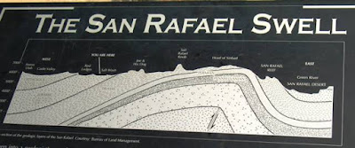
The first photo above was taken from I-70 looking south, from an overlook or viewpoint located near the center of the San Rafael Swell. The location is identified as the "you are here" position on the second photo. The white sandstone layers in the foreground of this first photo probably consist of the Jurassic Navajo Sandstone. Some stratigraphic information can be found at here, and the third photo above (from this website) shows some of the stratigraphy for the San Rafael Swell, with the San Rafael monocline or "reef" on the east side of the cross-section.
Above, the fourth photo looks northward from I-70 and shows the white upper part of the Navajo Sandstone cliff and the reddish lower part of the Navajo Sandstone cliff in the middle foreground, with the reddish ledge and slope-former below the sandstone cliffs possibly consisting of the Kayenta Formation - but it's possible the the sandstone cliffs include the Navajo Sandstone, the Kayenta Formation, and the underlying Wingate Formation sandstone, with the reddish slope-former then being part of the Chinle Formation. The Book Cliffs of Mancos Shale are the lower cliffs in the background, and the Roan Cliffs (the Green River Formation?) behind them. The brownish to golden slopes below the Navajo Sandstone may be part of the Chinle or Moenkopi Formations - but maybe not. This fourth photo shows the rock formations in the eastern part of the San Rafael Swell, just as one is about to drop over the edge and drive across the monocline or reef.
Above, the Navajo Sandstone and underlying Kayenta Formation (?) show an abrupt change in dip as beds steepen in approach to the San Rafael Reef or monocline.
I-70 is about to drop precipitously over the edge of the monocline.
The last photo, above, looks southward from a rest stop on the east side of the monocline. The steep rock formations of east side of the anticline (San Rafael Swell) can be seen on the right side of the photo - Kim at All of My Faults are Stress-Related, has a much better photo of the San Rafael monocline or "reef" on the east side of the Swell; she also explains the structure and formation of the San Rafael Swell and monocline.
Other links worth checking out:
Castle Country has some photos, information, and links.
More links and photos at sanrafaelswell.org
A Guide to I-70 through Southeastern Utah
The geology of central and southeastern Utah: Itinerary for a one-day field trip
The blog Running Away has some great photos of the Swell.