Saturday, October 31, 2009

Highlights of Travel Day Three #1

I'm back to the intermittent series I started more than a week ago, which shows photos and geology from my travels to the GSA Annual Meeting - and back again, as soon as I get that far. Last you saw of this series, I had just arrived in Klamath Falls, Oregon, and was enjoying an IPA at a local pub. The morning of the third day dawned cloudy, with very nice lighting. I enjoyed the chill air, and walked around downtown KFalls while drinking coffee from a tiny styrofoam cup provided by the motel office. After several cupfuls, I finally got underway and headed north on Highway 97, which is now being called The Dalles-California Highway. I've always called Highway 97 in Oregon "The Bend Highway" - because it goes through Bend - and personally think that any highway running through Oregon should not be allowed to have the word "California" attached to it. I say this as a bred (barely) and born Oregonian.
Along the road, just barely north of town, you will come to a roadcut with some bright, white rocks (Google Maps location). I remember this roadcut from a very long time ago, when I was a young girl growing up in California (yes, the ignominy of it all). We traveled to Oregon at least yearly, often on this highway. A diatomite mine, now inactive, sits along the side of the highway just south of this roadcut - if I remember right. I didn't find an online reference to the old mine.
This is one of my favorite roadcuts. When I first drove the highway myself in 1975, I remembered the rocks from decades past. The white, diatomaceous lake sediments or mudstones of late Miocene to Pliocene age are overlain by a basalt flow (geologic map). You can see the upright columnar jointing in the flow.

Somewhere, in a box in some garage in Alaska, there might be a very old hand sample from this roadcut. Maybe.
Just around the corner to the north, Highway 97 goes into a straight stretch, pointing straight at several exposures of young-looking fault scarps belonging to the East Klamath Lake Fault Zone. The zone is seismically active. This article makes it look like there was a 1947 earthquake along or just north of the mapped zone, and this CVO page discusses the West and East Klamath Fault Zones in relation to Crater Lake and historic earthquakes. The fault can be seen in the large cinder/gravel mine to the right of the highway - which is accessible when it isn't active - and it can be seen in a very good and accessible exposure on the same hillside, just left of where the highway is pointing in the above photo.
To get to the best exposure I've seen, turn right on this paved road, then immediately turn left into the gravel ramp and old road seen in the center of the photo beyond the paved road. You can park somewhere along the old road, and then walk to the scarp.
This exposure of the fault scarp (Google Maps location) is accessible with some hiking up the steep slope. I didn't hike up this time, but have on previous occasions. I've also poked around the cinder/gravel mine, a few years back when it was closed. The fault places bedrock of basaltic cinders and possible flows against somewhat reddish older alluvium. It looked to me like younger, lighter brown talus was not offset by the fault. The fault surface is smooth, grooved, and slickensided, and compares favorably to the Genoa fault scarp south of Carson City for a great fault exposure.

I have some old non-digital photos of this Klamath Basin fault surface, and will surely scan them someday.
Fault surfaces are visible along the highway for several miles, mostly in areas where rocks are kept behind barriers and metal screens. The road is narrow, often with curves, and it cuts into a steep, talus-ridden hillside. Traffic is often incessant. There are a few small pullouts on the southbound side of the road - these are hard to stop in because they are so short. They also precipitously overhang the railroad, which is below the highway closer to the lake. I've stopped at one or two of these pullouts; they don't really provide very good access to the roadcuts.
At this pullout on the east side of Highway 97, you can look across Upper Klamath Lake and see several volcanoes. It was a bit cloudy, so I got decent photos of only two, Mount Harriman, above, and Pelican Butte, below. Mount Harriman is one of four (or more?) shield volcanoes inside the Mountain Lakes Wilderness. Pelican Butte is a shield volcano just northeast of Mount McLoughlin.

Just up the road apiece, I saw these signs, and made a sudden, unplanned side trip... to Crater Lake.

A Reference:
Priest, G. R., Hladky, F. R., and Murray, R. B., 2008, Geologic Map of the Klamath Falls area, Klamath County, Oregon: State of Oregon Dept. of Geol. and Mineral Resources, Map GMS-118.

Wednesday, October 28, 2009

Hanging Around

...at the GSA meeting. And what better place to do it than with a bunch of other geobloggers and geotweeters in a friendly pub? I didn't take many photos during our meetup-tweetup, but got this one of Callan Bentley - who said, at the time, that it was a "great" photo. Callan has a photo of 18 of the 19 bloggers right here. He and several others have written more extensively about the pub, the beer, and the bloggers. (Well, no one wrote much about the beer - I thought it was just great, but don't remember anything specific.) If I missed any writeups, go ahead and let me know!
Like I said, I really didn't take many photos in the pub, instead, I took some pics while a few of us were taking the train back across the river to the convention center area. Above: Jessica Ball of Magma Cum Laude and Ron Schott of Ron Schott's Geology Home Companion Blog.
More: Brian Romans of Clastic Detritus, Jim Lehane of Dino Jim's Musings, and Callan Bentley of NOVA Geoblog.
Here's Callan with Kyle House of Geologic Frothings and Fresh Geologic Froth, with Kim Hannula and All My Faults Are Stress Related looking on.
Anne Jefferson of Highly Allochthonous has been hanging on all this time, and is now conversing with Kim.

It was a great night, I enjoyed meeting so many geobloggers, and look forward to doing this again sometime! A full list of the blogger and tweeter attendees can be found at NOVA Geoblog.

Tuesday, October 27, 2009

Getting Back from GSA

I got back from the Portland GSA meeting yesterday, arriving beneath partly cloudy skies with scattered wave clouds like the ones above. I'm not sure I feel like I'm back, however - I have a huge number of things to do, including possibly driving back across the state again because of miscellaneous appointments. As far as blogging goes, in the next several days I'll be getting around to a few more travel and meeting highlights - from both before and after the meeting - but these updates may come along gradually as I try to settle in to some kind of post-travel schedule, while also working on laundry and other mundane things. I also want to review contacts I made at the meeting, update my resume more completely, and plan a bit for the next meeting - Northwest Mining in Reno in December.

Wednesday, October 21, 2009

GSA Report #2

It's Wednesday morning and raining steadily, unlike this shot from Monday morning. GSA Annual meeting events at the Oregon Convention Center are winding down somewhat: many geologists leave Tuesday night or Wednesday morning, though talks and posters continue through the day, and post-meeting field trips and short courses are still to come.
The exhibit hall, combined with the poster hall and graduate school recruiting booths, is huge - none of the pictures I've taken really show the size - I'd need to stitch together a full-circle panorama, but maybe you can get an idea from this picture showing a portion of half of the exhibits. Photos aren't allowed in the poster area behind me.
Geologists, guests, and exhibitors walk down the "Geoscience Highway" - this is the center area of the exhibit hall, with the photo looking from one end to the other. About half the exhibits are on each side of this central dividing area. This year, the GSA has internet cafes of ready-to-use computers scattered through the meeting halls, including one inside the exhibits. Wifi is available everywhere that I've tried connecting, for those who've brought their own computers or smartphones.
One of the reasons I've always liked coming to annual and sectional GSA meetings is to cruise the rock and mineral booths. This year, there are many; they offer rocks, minerals, fossils, jewelry, and other items made from polished rock and stone.

And now for a summary of where I've been and what I've done. Yesterday, I spent a good portion of the morning and afternoon in the SEG sessions on Magmas and Volatiles: Linking Granites, Volcanoes, Geothermal Systems, and Mineral Deposits I & II (158 and 204). These sessions covered a wide range of topics from porphyry copper deposits to Carlin-type gold deposits, from zircons to fluid inclusions, and from subduction to low-angle normal faulting.

In the afternoon, I also bounced around the convention center, going to talks by various individuals including one by my first employer and mentor, a talk by geoblogger Brian Romans (200-8), and a talk by geoblogger Kim Hannula (200-12).

For the evening, I was invited to the QG&G awards meeting by Bud Burke, an old friend of mine from ties that go back as far as early grad school. I saw several old friends there, reconnected with people I hadn't expected to see, and actually managed to conduct some business relating to a Pleistocene lake in central Nevada. A paper about the lake will finally be published; I'll be a co-author when it comes out, probably because I provided the initial information about the area and was there when the first work was done, and because I tried to get the ball rolling on the article way back in the early 1990's. I'll say more about that when the paper is published.

Today I plan to be in the SEG sessions most of the day: morning and afternoon.

Be the way, summary posts about the GSA meetings by various geobloggers can be found at this GSA page: From the Blogosphere. I don't think the list is complete.

Monday, October 19, 2009

GSA Meeting Report 1

I arrived in Portland Friday night, which was a bit early, so I spent most of Saturday getting ready for the meeting: picking up my badge and free drink tokes for Sunday through Wednesday receptions, setting up my approximate meeting schedule, meeting and socializing with Kim Hannula and others near one of the Starbucks, and going to the GSA Awards reception, which had free wine, beer, and food after a series of great and moving awards.

Sunday was a day of many talks. The annual GSA meeting is a large meeting if you measure by the number of scientific talks given. On Sunday morning, 24 sessions of about 14 talks each were running simultaneously in 24 separate meeting rooms. That many sessions run simultaneously every morning and every afternoon (about 48 sessions per day not counting posters which change daily) for 4 days in a row. This gives me ample opportunity to want to be in more than two places at once, besides trying to squeeze in going to poster sessions and the exhibit hall. Sunday morning, I spent some time at the SEG talks on porphyry copper deposits and gold and copper transport in crustal fluids (1), and finding those somewhat dry, I bounced over to the detachment session (12), which was on the opposite side of the large Oregon Convention Center. There I learned about such things as 'mini-detachments' and graded sandy layers in fault zones. Then I bounced back to find out how soil samples reflect the West and East Pebble deposit at depth (well and hardly at all, respectively).

That was Sunday morning. For the afternoon, I decided to attend only one session, so stayed in the Google Earth to Geoblogs session (53), where several fellow geobloggers - and others - gave excellent and inspiring talks and demonstrations. I met several bloggers I hadn't met before, including Ron Schott, Jim Repka, Callan Bentley, and Lee Allison. I expect to meet several more, along with #geotweeters, tonight at a planned get-together.

Today, the morning seems slow to me as far as talks go. Yes, there are 24 sessions going on right now, and some very interesting talks scattered here and there through the convention center. I'm attending the exhibit hall and blogging, rather than going to morning talks. This afternoon, I get to choose between Volcanism, Impact, and Mass Extinctions (133), Geology in the National Parks (136), LIPs (138), and Virtual Globes to Geoblogs (144). I haven't yet decided!

The best part of meetings, though, is meeting people, which for me often involves seeing people I haven't seen in 10 to 20 years. If you stay in the talks all day long, you don't see anyone - wandering around the exhibits and posters and going to the evening socializing events is something I highly recommend.

I thought I'd show you a couple photos - of the convention center and exhibit hall - but I left my camera downloading cord over in the hotel.

I'll try to have another meeting update, but don't promise anything.

Saturday, October 17, 2009

Highlights of the Day: Travel Day Two

I'm already at the national GSA Meeting in Portland, but I took my time getting here, four days to be precise. Here are a few highlights from travel day two.
The lighting was great between Susanville and Klamath Falls. Here, I'm dropping into a Basin and Range valley, the valley that's home to Eagle Lake (MSRMaps link). Eagle Lake, which is reported to be a closed basin with no hydrologic outlet, is shown as being either in or out of the Great Basin, depending on whose map you use. Eagle Lake was not connected to Pleistocene Lake Lahontan.
Eagle Lake (Google Maps link), looking almost west, from Highway 139.
This is a basalt dike on the east side of Highway 139, just south of Lassen County Milepost 52 (Google Maps location), and just before you get to the Willow Creek Campground if you're driving north.
The columnar jointing in the dike is nearly horizontal, making the rock look like a bunch of stacked logs.
Looking end-on at the pile of stacked logs, the cross-section through the stacked columns shows the typical though irregular polygonal shapes common to basalt columns. Kim posted about another dike with horizontal columnar joints earlier this year, and Andrew's article on basalt columns has a great photo of a piece of basalt with an almost perfect hexagonal shape. It seems like I've seen another post more recently on columnar jointing, but I'm not finding it right now.
Closer to my KFalls destination, it started raining, but without the intensity of the previous day.
And then there was the IPA awaiting me at The Creamery Brew Pub & Grill . . .

Thursday, October 15, 2009

Mid-Monthly Art: Mojave Hilton

This brightly painted version of The Mojave Hilton is based on an old, now faded photograph of the miner's shack or hunting cabin known as the Mojave Hilton, which is located in the Vontrigger Hills of California. I'm not going to give the precise location, because the shack has seen some ill use in the past few years or decades. The area is inside the East Mojave National Preserve (1994), formerly known as the East Mojave Scenic Area (1980).
hilton 1985 This photo, now part of a cut-to-pieces collage, was taken in 1985 by the second geologist in the picture - that's right, the one that isn't me! I don't know how my 1981 field partner and I missed this cabin - we probably drove right by while focusing on volcanic rocks of the nearby Castle Mountains and the even closer Hackberry Mountain.sign

Back in '85, a sign over the door said "something Hilton," although all I can read now is the "Hilton" part, even on the original print.

The Mojave Hilton was used by hunters when we visited in 1985. The front steps were almost new. Although I never met anyone while stopping by, a sign-in book and wall sign-in lists made it clear that the place was used on a fairly regular basis.
hilton 2009 This is the way the Mojave Hilton looked in early May, 2009: a little bit worse for wear, but still hanging in there.
door1 These newer photos show that the sign over the door is gone.
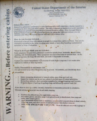
door2 Instead, the door has a hantavirus warning, which was plastered on by DOI.
warning "DO NOT SWEEP OR VACUUM." Thanks. I wasn't planning on it!
1983 sign I did go in, though - it's an irresistable pastime of exploration geologists: examine every shack or cabin you find in the field, providing that the interior is sound. The note above was written in June, 1983. It names the cabin as "THE MOJAVE HILTON" and mentions the new front steps and other improvements.
wall Typical sign-ins on the wall. I don't remember for sure if there was a sign-in book or not. For sure there was one in either this cabin OR another semi-nearby, well-kept cabin, but I'm not sure which one had the book.
stove The stove that was new in 1983.
kitchen The kitchen area.
bedroom The bedroom area. Here's where you can see the disorder that the cabin has come to. To clean up, you'd need serious dust protection. The business cards overhead are another way of signing in. (I didn't leave one!)
The Mojave Hilton from the rear, showing the classic western way of holding the roof on by adding rocks - protection against windstorms.
The Mojave Hilton, as seen from the old mine shaft that the cabin was originally built to service, with the volcanic rocks of Hackberry Mountain in the background.
This is the main shaft (or decline) where someone went after whatever they thought was minable on this property. The mine dump shows signs of quartz and minor sulfides. The dump is small, though - either the mine didn't go deep, or some rock was hauled to an unknown mill.
A closer look, which I took by holding my camera at the proper angle and rotating the screen, not by actually getting closer. The timbers look a little rotten in places. The country rock, gneiss or granite, is shot with narrow stockworky veins of unknown type.
And looking farther down the decline - hey, I'm not going in there, you shouldn't either! Especially don't trust that rickety-looking ladder.
It would be a nice place to live, don't you think?

Copyright © 2009 Looking for Detachment.
Original watercolor Copyright © 2002.
All Rights Reserved.


Wednesday, October 14, 2009

Through the Rain

Yesterday, my travels toward the GSA meeting in Portland, Oregon, took me across Nevada into the face of the oncoming storm.
cloud Lenticular cloud in eastern Nevada.

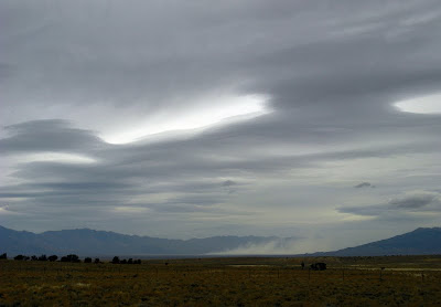
dust Dust storm, with overhead mass of lenticulars, while approaching Eureka.
rain Serious rain started as I crossed Big Smoky Valley and drove toward the Toiyabe Range. I couldn't hardly see the mountains until I got into them, and Big Smoky Valley to the south was a near whiteout (gray-out?) from the rain and low clouds.
mountains Looking south toward the west side of the Toiyabe Range from the center of Reese River Valley: clouds roil over the back side of the mountain near Big Creek.

A relatively dry spell ensued, until somewhere east of Fallon.
windmill Good news! The windmill is back up and running at West Gate. A lot of happy cows were lying down in the nearby field. Happy cows are ones that are lying down, rather than having to stand up and spend their entire time eating. Cows aren't usually that "happy" in the desert and steppe rangelands of Nevada and southern California (the Mojave Desert).

Driving from Fallon onward included barely being able to see with windshield wipers going full blast from the intensity of the rain and from semis splashing water all over while passing me in the canyon of the Truckee River east of Reno. There was enough standing water on the roads to cause unexpected hydroplaning in places - and the winds were blasting sideways across the water-sheeted concrete highway between Fallon and Fernley, strong enough locally to push my truck sideways.

Oh, and how much gas did I have? Usually that isn't a problem for me, but I didn't want to stop and risk getting completely drenched, didn't want to stop and risk driving over the mountain pass in the coming darkness. My odometer seemed to be telling me I had been getting 20 mpg or more for the last 400 to 500+ miles. Since I couldn't believe that, I chose to think I had not reset the odometer, and must not have traveled as far as it said, thus giving me enough gas to get to my destination without refilling. About 40 miles from the next gas station, I did the math and realized that with less than a quarter of a 30 gallon tank, I had really gone 560+ miles, another 40 would make that 600 miles, a precise 20 mpg. I usually fill up at 500 miles, and although I probably had enough gas to make it 40 miles - probably, maybe - I turned around and drove back less than a quarter mile to the last gas station, getting a little damp for the trouble. I'm packed for wet and cold weather, but was only dressed for cold.
sun Finally, after driving through the most consistently intense rainstorm I've seen in Nevada for a long time - over a broad area from east of Fallon to beyond Reno - I spotted this bit of clearing on Highway 395 south of the Honey Lake rest stop.